|
|
 |
|

|
|
|
Spatial delineation methods of urban areas |
WU Jiang1( ), LIU Chun2(), YING Shen3, YU Ting4 ), LIU Chun2(), YING Shen3, YU Ting4 |
1. College of Architecture and Urban Planning, Tongji University, Shanghai 200092, China
2. College of Surveying and Geo-Informatics, Tongji University, Shanghai 200092, China
3. School of Resource and Environmental Sciences, Wuhan University, Wuhan 430072, China
4. Urban Mobility Institute, Tongji University, Shanghai 200092, China |
|
|
|
|
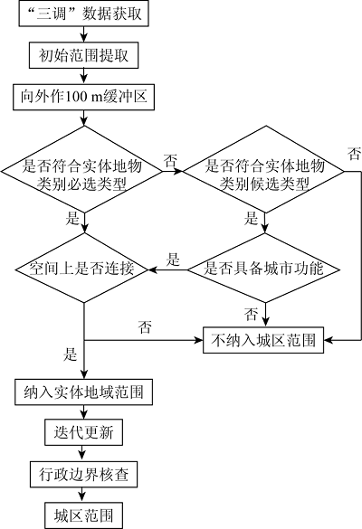
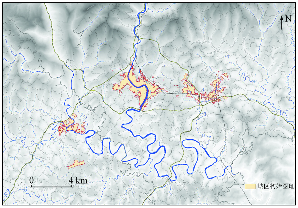
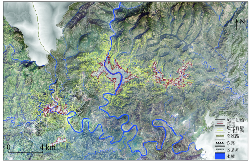
Abstract The scientific and reasonable delineation of an urban area serves as an important basis for making urban and rural statistics, formulating urban and rural policies, and implementing land space planning. At present, a unified concept system and unified delimitation methods of urban areas are yet to be established, which brings a lot of uncertainty to the formulation and implementation of land space planning. Therefore, aiming at the problems of the fuzzy concept, inconsistent demarcation methods, unclear spatial boundaries, this paper defined the spatial connotation of urban areas based on extensive research and proposed the spatial delimitation method of urban areas using surveying and mapping geographic information and the techniques such as remote sensing. Based on the data of the Third National Land Survey, this study determined the surface features incorporated into urban areas according to urban land use characteristics and spatial connection successively, in order to extract the spatial scopes of urban areas. Finally, taking Bazhong City as a case study, the rationality and feasibility of the process were verified, indicating that the method can be used in the extraction of the spatial scopes of urban areas and has the value of widespread applications.
|
| Keywords
urban area
spatial delineation
Third National Land Survey
urban land use characteristics
spatial connection
|
|
|
|
Corresponding Authors:
LIU Chun
E-mail: wujiang@tongji.edu.cn;liuchun@tongji.edu.cn
|
|
Issue Date: 23 December 2021
|
|
|
| [1] |
张良悦. 中国城镇化进程中农地非农化的偏离与矫正[J]. 区域经济评论, 2020(3):79-89.
|
| [1] |
Zhang L Y. The Deviation and adjustments of farmland conversion in the process of urbanization in China[J]. Regional Economic Review, 2020(3):79-89.
|
| [2] |
张立. 城镇化新形势下的城乡(人口)划分标准讨论[J]. 城市规划学刊, 2011(2):77-85.
|
| [2] |
Zhang L. A discussion on the definition of urban/rural population in the Chinese urbanization process[J]. Urban Planning Forum, 2011(2):77-85.
|
| [3] |
周一星. 城市规划寻路[M]. 北京: 商务印书馆, 2013.
|
| [3] |
Zhou Y X. Urban planning pathfinding[M]. Beijing: the Commercial Press, 2013.
|
| [4] |
黄中, 钱亚畅. 城乡划分标准的变迁[J]. 中国统计, 2004(2):6-7.
|
| [4] |
Huang Z, Qian Y C. The vicissitudes of urban and rural division standard[J]. China Statistical, 2004(2):6-7.
|
| [5] |
戚伟, 王开泳. 中国城市行政地域与实体地域的空间差异及优化整合[J]. 地理研究, 2019,38(2):207-220.
doi: 10.11821/dlyj020180881
|
| [5] |
Qi W, Wang K Y. City administrative area and physical area in China:Spatial differences and integration strategies[J]. Geographical Research, 2019,38(2):207-220.
|
| [6] |
国家统计局设管司. 统计上划分城乡的规定[EB/OL]. http://www.stats.gov.cn/tjsj/tjbz/200610/t20061018_8666.html.
url: http://www.stats.gov.cn/tjsj/tjbz/200610/t20061018_8666.html
|
| [6] |
State Statistics Bureau. Provisions for the statistical division of urban and rural areas[EB/OL]. http://www.stats.gov.cn/tjsj/tjbz/200610/t20061018_8666.html.
url: http://www.stats.gov.cn/tjsj/tjbz/200610/t20061018_8666.html
|
| [7] |
汪阳. 我国城乡划分标准研究[D]. 成都:西南交通大学, 2012.
|
| [7] |
Wang Y. Research on the standards of urban and rural division in China[D]. Chengdu:Southwest Jiaotong University, 2012.
|
| [8] |
冯健. 城乡划分与监测[M]. 北京: 科学出版社, 2012.
|
| [8] |
Feng J. Urban and rural division and monitoring[M]. Beijing: Science Press, 2012.
|
| [9] |
徐强, 华晨. 城市建成区面积统计口径亟待统一——以杭州中心城区为例[J]. 规划师, 2005(4):88-91.
|
| [9] |
Xu Q, Hua C. Establishing a uniform standard for calculation of urban built-up area:With Hangzhou central city zone as an example[J]. Planners, 2005(4):88-91.
|
| [10] |
华晨, 洪祎丹, 王颖芳, 等. 城镇建成区概念与界定方法体系研究——以浙江德清市武康镇为例[J]. 城市规划学刊, 2013(2):57-62.
|
| [10] |
Hua C, Hong Y D, Wang Y F, et al. The concept and definition of urban built-up area:A case of Wukang Town in Zhejiang Province[J]. Urban Planning Forum, 2013(2):57-62.
|
| [11] |
沈洁, 罗翔. 英国城乡地域的划分:标准、方法与历程[J]. 规划师, 2015,31(8):139-144.
|
| [11] |
Shen J, Luo X. British urban and rural areas division:Standard,approach,and process[J]. Planners, 2015,31(8):139-144.
|
| [12] |
国务院发展研究中心“中国特色城镇化的战略和政策研究”课题组, 侯云春, 韩俊, 沈洁, 等. 城乡空间边界划分的国际经验及启示[J]. 中国发展观察, 2010(7):54-57.
|
| [12] |
Research group of “Strategy and Policy Research on Urbanization with Chinese Characteristics”,Development Research Center of the State Council, Hou Y C, Han J, et al. International experience and enlightenment on the division of urban and rural spatial boundaries[J]. China Development Observation, 2010(7):54-57.
|
| [13] |
周一星, 史育龙. 建立中国城市的实体地域概念[J]. 地理学报, 1995(4):289-301.
doi: 10.11821/xb199504001
|
| [13] |
Zhou Y X, Shi Y L. Toward establishing the concept of physical urban area in China[J]. Acta Geographica Sinica, 1995(4):289-301.
|
| [14] |
惠彦, 金志丰, 陈雯. 城乡地域划分和城镇人口核定研究——以常熟市为例[J]. 地域研究与开发, 2009,28(1):42-46.
|
| [14] |
Hui Y, Jin Z F, Chen W. Study on urban-rural Area division and urban population counting——The case of Changshu City[J]. Areal Research and Development, 2009,28(1):42-46.
|
| [15] |
宋小冬, 柳朴, 周一星. 上海市城乡实体地域的划分[J]. 地理学报, 2006(8):787-797.
|
| [15] |
Song X D, Liu P, Zhou Y X. The division of urban and rural entities in Shanghai[J]. Acta Geographica Sinica, 2006(8):787-797.
|
| [16] |
Friedl M A, Mciver D K, Hodges J, et al. Global land cover mapping from MODIS:Algorithms and early results[J]. Remote Sensing of Environment, 2002,83(1-2):287-302.
doi: 10.1016/S0034-4257(02)00078-0
url: https://linkinghub.elsevier.com/retrieve/pii/S0034425702000780
|
| [17] |
Gao F, Colstoun E D, Ma R, et al. Mapping impervious surface expansion using medium-resolution satellite image time series:A case study in the Yangtze River Delta,China[J]. International Journal of Remote Sensing, 2012,33(24):7609-7628.
doi: 10.1080/01431161.2012.700424
url: https://www.tandfonline.com/doi/full/10.1080/01431161.2012.700424
|
| [18] |
Wang H, Ning X, Zhang H, et al. Urban boundary extraction and urban sprawl measurement using high-resolution remote sensing images:A case study of China’s provincial capital[C]//International Archives of the Photogrammetry,Remote Sensing and Spatial Information Sciences, 2018
|
| [19] |
陆张维, 徐丽华, 吴次芳, 等. 基于凸壳原理的杭州城市扩展形态演化分析[J]. 地理科学, 2015,35(12):42-50.
|
| [19] |
Zhang L W, Xu L H, Wu C F, et al. The evolution of urban expansion morphology in Hangzhou based on principle of convex hull[J]. Scientia Geographica Sinica, 2015,35(12):42-50.
|
| [20] |
邓书斌, 武红敢, 江涛. 基于PCA/NDVI的森林覆盖遥感信息提取方法研究[J]. 国土资源遥感, 2007(2):82-85.doi: 10.6046/gtzyyg.2007.02.21.
doi: 10.6046/gtzyyg.2007.02.21
|
| [20] |
Deng S B, Wu H G, Jiang T. An approach to the extraction of remotely-sensed information of forest coverage based on PCA/NDVI[J]. Remote Sensing for Land and Resources, 2007(2):82-85.doi: 10.6046/gtzyyg.2007.02.21.
doi: 10.6046/gtzyyg.2007.02.21
|
| [21] |
孙宇翼, 赵军利, 王苗苗, 等. 基于J48决策树的面向对象方法的土地覆被信息提取[J]. 国土资源遥感, 2016(4):156-163.doi: 10.6046/gtzyyg.2016.04.24.
doi: 10.6046/gtzyyg.2016.04.24
|
| [21] |
Sun Y Y, Zhao J L, Wang M M, et al. Land cover information extraction from remote sensing images using object-based image analysis method integrated with decision tree[J]. Remote Sensing for Land and Resources, 2016(4):156-163.doi: 10.6046/gtzyyg.2016.04.24.
doi: 10.6046/gtzyyg.2016.04.24
|
| [22] |
Yin C L, Meng F, Guo L, et al. Extraction and evolution analysis of urban built-up areas in Beijing,1984—2018[J]. Applied Spatial Analysis and Policy, 2021,14:731-753.
doi: 10.1007/s12061-021-09374-7
url: https://doi.org/10.1007/s12061-021-09374-7
|
| [23] |
胡忆东, 吴志华, 熊伟, 等. 城市建成区界定方法研究——以武汉市为例[J]. 城市规划, 2008(4):88-91,96.
|
| [23] |
Hu Y D, Wu Z H, Xiong W, et al. Research on the method of defining urban built-up area:A case study of Wuhan city[J]. City Planning Review, 2008(4):88-91,96.
|
| [24] |
刘钊, 廖斐凡, 赵桐. 基于PSPNet的遥感影像城市建成区提取及其优化方法[J]. 国土资源遥感, 2020,32(4):87-92.doi: 10.6046/gtzyyg.2020.04.12.
doi: 10.6046/gtzyyg.2020.04.12
|
| [24] |
Liu Z, Liao F F, Zhao T. Remote sensing image urban bulit-up area extraction and optimization method based on PSPNet[J]. Remote Sensing for Land and Resources, 2020,32(4):87-92.doi: 10.6046/gtzyyg.2020.04.12.
doi: 10.6046/gtzyyg.2020.04.12
|
| [25] |
许泽宁, 高晓路. 基于电子地图兴趣点的城市建成区边界识别方法[J]. 地理学报, 2016,71(6):928-939.
doi: 10.11821/dlxb201606003
|
| [25] |
Xu Z N, Gao X L. A novel method for identifying the boundary of urban built-up areas with POI data[J]. Acta Geographica Sinica, 2016,71(6):928-939.
|
| [26] |
中国国土勘测规划院, 自然资源部自然资源调查监测司. TD/T 1055—2019第三次全国国土调查技术规程[S]. 北京: 地质出版社, 2019.
|
| [26] |
Chinese Land Surveying and Planning Institute,Division of Natural Resources Survey and Monitoring,Ministry of Natural Resources. TD/T 1055—2019 Technical regulations for the third national land survey[S]. Beijing: Geological Publishing House, 2019.
|
| [27] |
国务院. 国务院关于调整城市规模划分标准的通知[EB/OL]. http://www.gov.cn/zhengce/content/2014-11/20/content_9225.htm.
url: http://www.gov.cn/zhengce/content/2014-11/20/content_9225.htm
|
| [27] |
The State Council. Notice of the State Council on readjustment of the standards for the division of urban dimensions[EB/OL]. http://www.gov.cn/zhengce/content/2014-11/20/content_9225.htm.
url: http://www.gov.cn/zhengce/content/2014-11/20/content_9225.htm
|
| [28] |
中国建筑工业出版社. GB/T 50280—98城市规划基本术语标准[S]. 北京: 中国建筑工业出版社, 1999.
|
| [28] |
China Architecture Publishing. GB/T 50280—98 Standard for basic terminology of urban planning[S]. Beijing: China Architecture Publishing, 1999.
|
| [29] |
王浩, 刘娅菲, 宁晓刚, 等. 城区边界遥感提取研究进展[J]. 测绘科学, 2019,44(6):159-165.
|
| [29] |
Wang H, Liu Y F, Ning X G, et al. Review on remote sensing extraction of urban boundary[J]. Science of Surveying and Mapping, 2019,44(6):159-165.
|
| [30] |
闫小培, 魏立华, 周锐波. 快速城市化地区城乡关系协调研究——以广州市“城中村”改造为例[J]. 城市规划, 2004(3):30-38.
|
| [30] |
Yan X P, Wei L H, Zhou R B. Research on the coordination be-tween urban and rural area in the rapid urbanization with the redevelopment of Guangzhou village-amid-the-city as a case[J]. City Planning Review, 2004(3):30-38.
|
| [31] |
张雪峰, 杨晏立, 何政伟, 等. 苏、锡、常建成区遥感方法提取及城市扩展分析[J]. 测绘科学, 2011,36(2):113-115.
|
| [31] |
Zhang X F, Yang Y L, He Z W, et al. Built-up area extraction by RS and urban expansion analysis of Suzhou,Wuxi and Changzhou[J]. Science of Surveying and Mapping, 2011,36(2):113-115.
|
| [32] |
国务院第三次全国国土调查领导小组办公室. 国务院第三次全国国土调查领导小组办公室关于印发《第三次全国国土调查实施方案》的通知[EB/OL]. http://gi.mnr.gov.cn/201811/t20181120_2367135.html.
url: http://gi.mnr.gov.cn/201811/t20181120_2367135.html
|
| [32] |
Office of the Third National Land Survey. Notice of the office of the third national land survey on the issuance of the implementation plan for the third national land survey[EB/OL]. http://gi.mnr.gov.cn/201811/t20181120_2367135.html.
url: http://gi.mnr.gov.cn/201811/t20181120_2367135.html
|
| [33] |
周晶. 从国际比较和历史演变看我国城镇化统计标准[J]. 中国统计, 2013(7):60-61.
|
| [33] |
Zhou J. The statistical standard of China’s urbanization from the perspective of international comparison and historical evolution[J]. China Statistics, 2013(7):60-61.
|
|
Viewed |
|
|
|
Full text
|
|
|
|
|
Abstract
|
|
|
|
|
Cited |
|
|
|
|
| |
Shared |
|
|
|
|
| |
Discussed |
|
|
|
|
 2021,
Vol. 33
2021,
Vol. 33