|
|
 |
|

|
|
|
Detection and assessment of the physical state of offshore artificial reefs |
LI Dong1,2,3( ), TANG Cheng1,2,3, ZOU Tao2, HOU Xiyong1,2,3() ), TANG Cheng1,2,3, ZOU Tao2, HOU Xiyong1,2,3() |
1. Key Laboratory of Coastal Zone Environmental Processes and Ecological Remediation, Chinese Academy of Sciences Yantai Institute of Coastal Zone Research, Chinese Academy of Sciences, Yantai 264003, China
2. Yantai Institute of Coastal Zone Research, Chinese Academy of Sciences, Yantai 264003, China
3. Ocean Mega-Science Center, Chinese Academy of Sciences, Qingdao 266071, China |
|
|
|
|
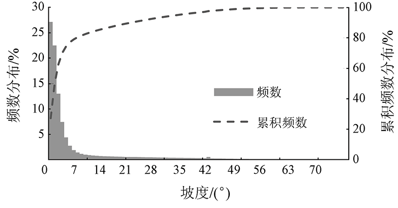
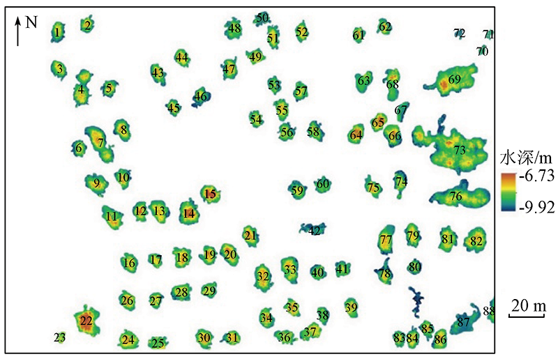
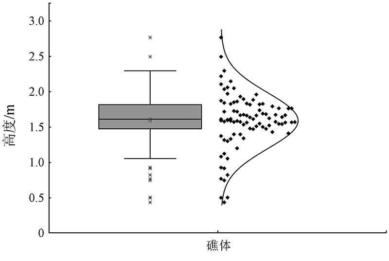
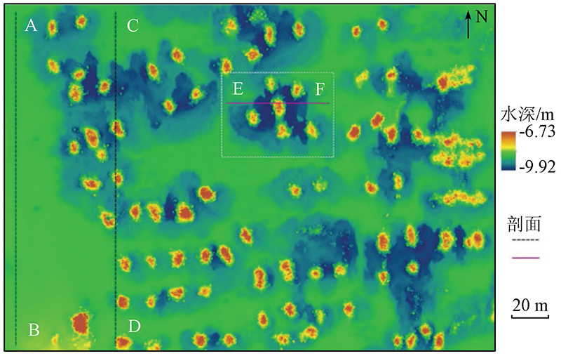
Abstract Mastering the subaqueous physical state of artificial reefs (ARs) is critical for assessing the benefits of ARs. Tradition survey methods suffer shortcomings such as low efficiency and incomplete information and cannot meet the requirements for the precise monitoring of ARs. This study established a high-precision DEM (digital elevation model) of ARs using a multibeam sonar system. Meanwhile, this study conducted a quantitative analysis of the distribution, height, volume, and complex topographic features of ARs using the GIS (geographic information system) spatial analysis method. The high-precision DEM was tested in an offshore AR area in Shandong Province, obtaining the following results. The AR area has a water depth of -9.92~-6.73 m. The ARs in the area are stacked in piles with different distances, with a total reef volume of 5 458.49 m3. Meanwhile, 50% of the ARs have a height of 1.48~1.82 m. The terrain characteristic variables such as slope, curvature, rugosity, and topographic relief intensively show high values in the reef distribution area. Affected by their own gravity and local hydrodynamic force, the ARs have a subsidence depth of about 0.5 m, leading to the formation of the special erosion and silting terrain around the ARs. This study can provide technical and data support for the monitoring and assessing the physical stability of ARs and thus is practically significant.
|
| Keywords
artificial reef (AR)
physical stability
multibeam sonar
GIS spatial analysis
|
|
|
|
Corresponding Authors:
HOU Xiyong
E-mail: dli@yic.ac.cn;xyhou@yic.ac.cn
|
|
Issue Date: 14 March 2022
|
|
|
| [1] |
Seaman W. Artificial habitats and the restoration of degraded marine ecosystems and fisheries[J]. Hydrobiologia, 2007, 580(1):143-155.
doi: 10.1007/s10750-006-0457-9
url: http://link.springer.com/10.1007/s10750-006-0457-9
|
| [2] |
杨红生, 许帅, 林承刚, 等. 典型海域生境修复与生物资源养护研究进展与展望[J]. 海洋与湖沼, 2020, 51(4):809-820.
|
| [2] |
Yang H S, Xu S, Lin C G, et al. Research progress and prospects of restoration and resource conservation in typical sea areas[J]. Oceanologia et Limnologia Sinica, 2020, 51(4):809-820.
|
| [3] |
林军, 章守宇. 人工鱼礁物理稳定性及其生态效应的研究进展[J]. 海洋渔业, 2006, 28(3):257-262.
|
| [3] |
Lin J, Zhang S Y. Research advances on physical stability and ecological effects of artificial reef[J]. Marine Fisheries, 2006, 28(3):257-262.
|
| [4] |
Tynyakov J, Rousseau M, Chen M, et al. Artificial reefs as a means of spreading diving pressure in a coral reef environment[J]. Ocean and Coastal Management, 2017, 149:159-164.
doi: 10.1016/j.ocecoaman.2017.10.008
url: https://linkinghub.elsevier.com/retrieve/pii/S0964569117305537
|
| [5] |
张立斌, 杨红生. 海洋生境修复和生物资源养护原理与技术研究进展及展望[J]. 生命科学, 2012, 24(9):1062-1069.
|
| [5] |
Zhang L B, Yang H S. Advances in principles and techniques of marine habitat restoration and biological resource conservation[J]. Chinese Bulletin of Life Science, 2012, 24(9):1062-1069.
|
| [6] |
唐衍力, 龙翔宇, 王欣欣, 等. 中国常用人工鱼礁流场效应的比较分析[J]. 农业工程学报, 2017, 33(8):97-103.
|
| [6] |
Tang Y L, Long X Y, Wang X X, et al. Comparative analysis on flow field effect of general artificial reefs in China[J]. Transactions of the Chinese Society of Agricultural Engineering, 2017, 33(8):97-103.
|
| [7] |
Schygulla C, Peine F. Nienhagen reef:Abiotic boundary conditions at a large brackish water artificial reef in the Baltic Sea[J]. Journal of Coastal Research, 2013, 29(2):478-486.
|
| [8] |
刘鸿雁, 杨超杰, 张沛东, 等. 基于Ecopath模型的崂山湾人工鱼礁区生态系统结构和功能研究[J]. 生态学报, 2019, 39(11):3926-3936.
|
| [8] |
Liu H Y, Yang C J, Zhang P D, et al. An Ecopath evaluation of system structure and function for the Laoshan Bay artificial reef zone ecosystem[J]. Acta Ecologica Sinica, 2019, 39(11):3926-3936.
|
| [9] |
Jiang Z, Liang Z, Zhu L, et al. Numerical simulation of effect of guide plate on flow field of artificial reef[J]. Ocean Engineering, 2016, 116:236-241.
doi: 10.1016/j.oceaneng.2016.03.005
url: https://linkinghub.elsevier.com/retrieve/pii/S0029801816001128
|
| [10] |
沈蔚, 张守宇, 李勇攀, 等. C3D测深侧扫声呐系统在人工鱼礁建设中的应用[J]. 上海海洋大学学报, 2013, 22(3):404-409.
|
| [10] |
Shen W, Zhang S Y, Li Y P, et al. The application of C3D bathymetry side scan sonar system in artificial reef construction[J]. Journal of Shanghai Ocean University, 2013, 22(3):404-409.
|
| [11] |
Hou Z, Chen Z, Wang J, et al. Acoustic impedance properties of seafloor sediments off the coast of Southeastern Hainan,South China Sea[J]. Journal of Asian Earth Sciences, 2018, 154:1-7.
doi: 10.1016/j.jseaes.2017.12.003
url: https://linkinghub.elsevier.com/retrieve/pii/S1367912017306788
|
| [12] |
Li D, Tang C, Xia C, et al. Acoustic mapping and classification of benthic habitat using unsupervised learning in artificial reef water[J]. Estuarine,Coastal and Shelf Science, 2017, 185:11-21.
doi: 10.1016/j.ecss.2016.12.001
url: https://linkinghub.elsevier.com/retrieve/pii/S0272771416307156
|
| [13] |
刘永虎, 刘敏, 田涛, 等. 侧扫声纳系统在石料人工鱼礁堆体积估算中的应用[J]. 水产学报, 2017, 41(7):1158-1167.
|
| [13] |
Liu Y H, Liu M, Tian T, et al. The application of side scan sonar system in volume estimation of stone artificial reef[J]. Journal of Fisheries of China, 2017, 41(7):1158-1167.
|
| [14] |
沈天跃, 章守宇, 沈蔚, 等. 现场海域人工鱼礁分布状态聚类分析[J]. 水产学报, 2015, 39(9):1350-1358.
|
| [14] |
Shen T Y, Zhang S Y, Shen W, et al. Cluster analysis on distribution status of artificial reefs in field sea area[J]. Journal of Fisheries of China, 2015, 39(9):1350-1358.
|
| [15] |
郭栋, 董婧, 付杰, 等. 基于双频识别声呐的东港大鹿岛人工鱼礁调查研究[J]. 海洋湖沼通报, 2018(2):41-48.
|
| [15] |
Guo D, Dong J, Fu J, et al. Artificial reef and fisheries estimation in Dalu Island based on dual frequency sonar[J]. Transactions of Oceanology and Limnology, 2018(2):41-48.
|
| [16] |
Yoon H S, Kim D, Na W B. Estimation of effective usable and burial volumes of artificial reefs and the prediction of cost-effective management[J]. Ocean and Coastal Management, 2016, 120:135-147.
doi: 10.1016/j.ocecoaman.2015.12.007
url: https://linkinghub.elsevier.com/retrieve/pii/S096456911530082X
|
| [17] |
李东, 唐诚, 邹涛, 等. 基于多波束声呐的人工鱼礁区地形特征分析[J]. 海洋科学, 2017, 41(5):127-133.
|
| [17] |
Li D, Tang C, Zou T, et al. Terrain character analysis of artificial reefs area based on multibeam echo sounder[J]. Marine Sciences, 2017, 41(5):127-133.
|
| [18] |
Lurton X. Swath bathymetry using phase difference:Theoretical analysis of acoustical measurement precision[J]. IEEE Journal of Oceanic Engineering, 2000, 25(3):351-363.
doi: 10.1109/48.855385
url: http://ieeexplore.ieee.org/document/855385/
|
| [19] |
徐志敏, 林志勇, 李雯静, 等. 基于填挖方分析的DEM精度评价模型[J]. 武汉大学学报(信息科学版), 2017, 42(8):1167-1171.
|
| [19] |
Xu Z M, Lin Z Y, Li W J, et al. DEM accuracy evaluation model based on cut fill method[J]. Geomatics and Information Science of Wuhan University, 2017, 42(8):1167-1171.
|
| [20] |
徐国强, 杜军, 田梓文, 等. 近海海底不规则堆积体体积高精度量算技术与应用[J]. 海岸工程, 2017, 36(4):30-36.
|
| [20] |
Xu G Q, Du J, Tian Z W, et al. High precision measurement technology for the volume of submarine irregular accumulations in coastal waters and its application[J]. Coastal Engineering, 2017, 36(4):30-36.
|
| [21] |
Yun D H, Kim Y T. Experimental study on settlement and scour characteristics of artificial reef with different reinforcement type and soil type[J]. Geotextiles and Geomembranes, 2018, 46(4):448-454.
doi: 10.1016/j.geotexmem.2018.04.005
url: https://linkinghub.elsevier.com/retrieve/pii/S026611441830027X
|
| [22] |
王佳美, 唐振朝, 丁玲, 等. 基于水槽模型试验的人工鱼礁局部冲淤研究[J]. 南方水产科学, 2020, 16(6):32-38.
|
| [22] |
Wang J M, Tang Z Z, Ding L, et al. Study on local scour of artificial reef based on flume test[J]. South China Fisheries Science, 2020, 16(6):32-38.
|
| [23] |
邹涛, 张立斌, 张华, 等. 基于长期定点观测资料的莱州湾人工鱼礁建设区局地水动力特征[J]. 海洋与湖沼, 2018, 49(2):280-289.
|
| [23] |
Zou T, Zhang L B, Zhang H, et al. Hydrodynamic characteristics in the artificial reefing construction area in Laizhou Bay:Based on a continuous long-term observation[J]. Oceanologia et Limnologia Sinica, 2018, 49(2):280-289.
|
| [24] |
Ha H K, Maa P Y, Holland C W. Acoustic density measurements of consolidating cohesive sediment beds by means of a non-intrusive “Micro-Chirp” acoustic system[J]. Geo-Marine Letters, 2010, 30(6):585-593.
doi: 10.1007/s00367-010-0206-y
url: http://link.springer.com/10.1007/s00367-010-0206-y
|
|
Viewed |
|
|
|
Full text
|
|
|
|
|
Abstract
|
|
|
|
|
Cited |
|
|
|
|
| |
Shared |
|
|
|
|
| |
Discussed |
|
|
|
|
 2022,
Vol. 34
2022,
Vol. 34