|
|
|
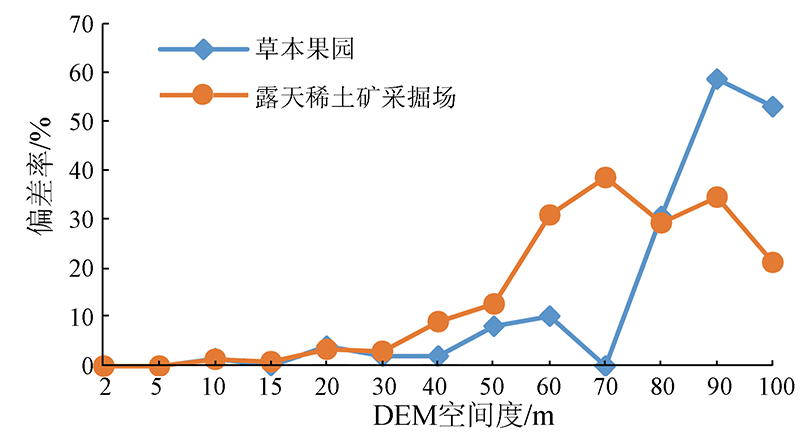
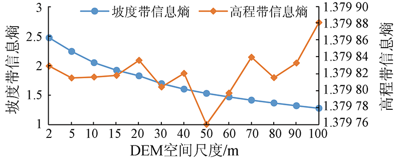
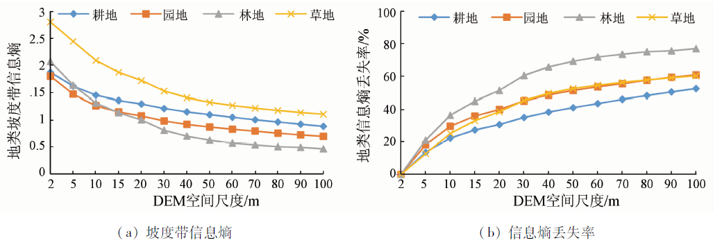
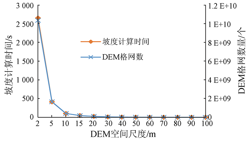
Abstract Accurate, detailed, and three-dimensional land type statistical data with an appropriate resolution is greatly significant for the natural resources monitoring, supervision, and ecological protection in coastal zones. A land type statistical model needs the support of DEM. However, there is little studies on the adaptability between the DEM resolution and the statistical model. Given this, this study proposed an optimization method of DEM resolution for land type statistical model of coastal zones. Specifically, this study systematically explored the impacts of DEM resolution on land type statistical model, selected indices and constructed an assessment model from four aspects, namely statistical accuracy, generality, information amount, and calculation efficiency. Then, this study determined the index weight using the entropy weight method and obtained the optimal DEM resolution through weighted calculation. The results are as follows. ①An increase in the DEM resolution led to the increasingly apparent negative impacts on the statistical accuracy and information amount and the increasingly significant positive effects on the generalization of the model. ②To meet the requirements of statistical accuracy, the DEM resolution should not exceed 30 m. Meanwhile, as required by the landform generalization, the DEM resolution should not be less than 10 m. ③There is a linear positive correlation between the calculation time of spatial operations and the number of DEM grids. ④Based on the comprehensive assessment using the weights calculated by the entropy weight method, the optimal DEM resolution was 10 m. The method of DEM resolution developed in this paper is universal and can be expanded in the natural resource statistics of coastal zones and in the land type statistics of other surveys and monitoring.
|
| Keywords
coastal zone
land type statistics
DEM resolution
information entropy
entropy weight method
|
|
|
|
Corresponding Authors:
CHEN Chao
E-mail: jiangna123321@163.com;chenchao@zjou.edu.cn
|
|
Issue Date: 14 March 2022
|
|
|
| [1] |
李清泉, 卢艺, 胡水波, 等. 海岸带地理环境遥感监测综述[J]. 遥感学报, 2016, 20(5):1216-1229.
|
| [1] |
Li Q Q, Lu Y, Hu S B, et al. Review of remotely sensed geo-environmental monitoring of coastal zones[J]. Journal of Remote Sensing, 2016, 20(5):1216-1229.
|
| [2] |
陈超, 陈慧欣, 陈东, 等. 舟山群岛海岸线遥感信息提取及时空演变分析[J]. 自然资源遥感, 2021, 33(2):141-152.doi: 10.6046/gtzyyg.2020248.
doi: 10.6046/gtzyyg.2020248
|
| [2] |
Chen C, Chen H X, Chen D, et al. Coastline extraction and spatial-temporal variations using remote sensing technology in Zhoushan islands[J]. Remote Sensing for Land and Resources, 2021, 33(2):141-152.doi: 10.6046/gtzyyg.2020248.
doi: 10.6046/gtzyyg.2020248
|
| [3] |
杨长坤, 刘召芹, 王崇倡, 等. 2001—2013年辽东湾海岸带空间变化分析[J]. 自然资源遥感, 2015, 27(4):150-157.doi: 10.6046/gtzyyg.2015.04.23.
doi: 10.6046/gtzyyg.2015.04.23
|
| [3] |
Yang C K, Liu Z Q, Wang C C, et al. Spatial change analysis of the coastal zone of Liaodong Bay from 2001 to 2013[J]. Remote Sensing for Land and Resources, 2015, 27(4):150-157.doi: 10.6046/gtzyyg.2015.04.23.
doi: 10.6046/gtzyyg.2015.04.23
|
| [4] |
李秀梅, 袁承志, 李月洋. 渤海湾海岸带遥感监测及时空变化[J]. 自然资源遥感, 2013, 25(2):156-163.doi: 10.6046 /gtzyyg.2013.02.26.
doi: 10.6046 /gtzyyg.2013.02.26
|
| [4] |
Li X M, Yuan C Z, Li Y Y. Remote sensing monitoring and spatial-temporal variation of Bohai Bay coastal zone[J]. Remote Sensing for Land and Resources, 2013, 25(2):156-163.doi: 10.6046 /gtzyyg.2013.02.26.
doi: 10.6046 /gtzyyg.2013.02.26
|
| [5] |
董春, 张继贤, 刘纪平, 等. 高精度地理数据空间统计分析模型与方法[J]. 遥感信息, 2016, 31(1):13-19.
|
| [5] |
Dong C, Zhang J X, Liu J P, et al. Models and methods of spatial statistics and analysis based on high-precision data[J]. Remote Sensing Information, 2016, 31(1):13-19.
|
| [6] |
秦承志, 呼雪梅. 栅格数字地形分析中的尺度问题研究方法[J]. 地理研究, 2014, 33(2):270-283.
doi: 10.11821/dlyj201402007
|
| [6] |
Qin C Z, Hu X M. Review on scale-related researches in grid-based digital terrain analysis[J]. Geographical Research, 2014, 33(2):270-283.
|
| [7] |
陈楠, 林宗坚, 李成名, 等. 1:10 000及1:50 000比例尺DEM信息容量的比较——以陕北韭园沟流域为例[J]. 测绘科学, 2004, 29(3):39-41.
|
| [7] |
Chen N, Lin Z J, Li C M, et al. A comparison on DEM of different scale in loess hill and gully area[J]. Science of Surveying and Mapping, 2004, 29(3):39-41.
|
| [8] |
邓仕虎, 杨勤科. DEM采样间隔对地形描述精度的影响研究[J]. 地理与地理信息科学, 2010, 26(2):23-26.
|
| [8] |
Deng S H, Yang Q K. Study on the influence of sampling interval on DEM representation accuracy[J]. Geography and Geo-Information Science, 2010, 26(2):23-26.
|
| [9] |
汤国安, 刘学军, 房亮, 等. DEM及数字地形分析中尺度问题研究综述[J]. 武汉大学学报(信息科学版), 2006, 31(12):1059-1066.
|
| [9] |
Tang G A, Liu X J, Fang L, et al. A review on the scale issue in DEMs and digital terrain analysis[J]. Geomatics and Information Science of Wuhan University, 2006, 31(12):1059-1066.
|
| [10] |
李发源, 汤国安, 贾旖旎, 等. 坡谱信息熵尺度效应及空间分异[J]. 地球信息科学, 2007, 9(4):13-18.
|
| [10] |
Li F Y, Tang G A, Jia Y N, et al. Scale effect and spatial distribution of slope spectrum’s information entropy[J]. Geo-Information Science, 2007, 9(4):13-18.
|
| [11] |
潘换换, 吴树荣, 姬倩倩, 等. 山西煤田生态系统服务时空格局及驱动力[J]. 应用生态学报, 2021, 32(11):3923-3932.
|
| [11] |
Pan H H, Wu S R, Ji Q Q, et al. Spatio-temporal pattern and driving forces of ecosystem services in coalfields of Shanxi Province,China[J]. Chinese Journal of Applied Ecology, 2021, 32(11):3923-3932.
|
| [12] |
毋亭, 吴启航, 曹文琦, 等. DEM分辨率对苏北地区耕地土壤有机碳制图精度的影响研究[J/OL]. 中国农业资源与区划,(2021-0901)[2021-11-28].http://kns.cnki.net/kcms/detail/11.3513.S.20210831.1715.016.html.
url: http://kns.cnki.net/kcms/detail/11.3513.S.20210831.1715.016.html.
|
| [12] |
Wu T, Wu Q H, Cao W Q, et al. Research about what effect DEM resolution has on the digital soil organic carbon mapping for cultivated area in the north of Jiangsu Province[J/OL]. Chinese Journal of Agricultural Resources and Regional Planning,(2021 -09-01)[2021-11-28].https://kns.cnki.net/kcms/detail/11.3513.S.20210831.1715.016.html.
url: https://kns.cnki.net/kcms/detail/11.3513.S.20210831.1715.016.html.
|
| [13] |
郭春香, 梁音, 曹龙熹. 基于四种分辨率DEM的侵蚀模型地形因子差异分析[J]. 土壤学报, 2014, 51(3):482-489.
|
| [13] |
Guo C X, Liang Y, Cao L X. Geomorphic factors in DEM-based soil erosion models as affected by resolution[J]. Acta Pedologica Sinica, 2014, 51(3):482-489.
|
| [14] |
高玉芳, 陈耀登, 蒋义芳, 等. DEM 数据源及分辨率对HEC-HMS水文模拟的影响[J]. 水科学进展, 2015, 26(5):624-630.
|
| [14] |
Gao Y F, Chen Y D, Jiang Y F, et al. Effects of DEM source and resolution on the HEC-HMS hydrological simulation[J]. Advances in Water Science, 2015, 26(5):624-630.
|
| [15] |
沈定涛, 王结臣, 张煜, 等. 一种面向海量数字高程模型数据的洪水淹没区快速生成算法[J]. 测绘学报, 2014, 43(6):645-652.
|
| [15] |
Shen D T, Wang J C, Zhang Y, et al. A quick flood inundation algorithm based on massive DEM data[J]. Acta Geodaetica et Cartographica Sinica, 2014, 43(6):645-652.
|
| [16] |
王婷, 潘军, 蒋立军, 等. 基于DEM的地形因子分析与岩性分类[J]. 自然资源遥感, 2018, 30(2):231-237.doi: 10.6046/gtzyyg.2018.02.31.
doi: 10.6046/gtzyyg.2018.02.31
|
| [16] |
Wang T, Pan J, Jiang L J, et al. Topographic variable analysis and lithologic classification based on DEM[J]. Remote Sensing for Land and Resources, 2018, 30(2):231-237.doi: 10.6046/gtzyyg.2018.02.31.
doi: 10.6046/gtzyyg.2018.02.31
|
| [17] |
杨荣凤, 杨昆, 洪亮, 等. 基于不同空间分辨率DEM的地形因子分析比较[J]. 云南师范大学学报(自然科学版), 2018, 38(5):75-78.
|
| [17] |
Yang R F, Yang K, Hong L, et al. Comparison of terrain factor analysis based on DEM with different spatial resolution[J]. Journal of Yunnan Normal University(Natural Science Edition), 2018, 38(5):75-78.
|
| [18] |
国务院第一次全国地理国情普查领导小组办公室编著. 地理国情普查基本统计[M]. 北京: 测绘出版社, 2013:3-8.
|
| [18] |
Office of the Leading Group for the First National Geographic Survey of China. Basic statistics of the National Geographic Survey[M]. Beijing: Surveying and Mapping Press, 2013:3-8.
|
| [19] |
国家测绘局测绘标准化研究所. CH/T 9009.2—2010 基础地理信息数字成果1:5 000, 1:10 000,1:25 000,1:50 000,1:100 000数字高程模型[S]. 北京: 测绘出版社, 2010.
|
| [19] |
Institute of Surveying and Mapping Standardization of the State Bureau of Surveying and Mapping. CH/T 9009.2—2010 Digital products of fundamental geographic information 1:5 000,1:10 000,1:25 000,1:50 000,1:100 000 digital elevation models[S]. Beijing: Surveying and Mapping Press, 2010.
|
| [20] |
袁卫平. 地理统计空间计算效率优化模型研究[D]. 阜新:辽宁工程技术大学, 2015.
|
| [20] |
Yuan W P. Research on the optimization model of the spatial computation of geographical statistics[D]. Fuxin:Liaoning University of Engineering and Technology, 2015.
|
| [21] |
江娜. 山东省地理国情信息综合统计分析技术与实现[J]. 山东国土资源, 2018, 34(6):65-69.
|
| [21] |
Jiang N. Technology and realization of comprehensive statistical analysis of China geography information in Shandong Province[J]. Shandong Land and Resources, 2018, 34(6):65-69.
|
| [22] |
朱伟, 王东华, 周晓光. 基于信息熵的DEM最佳分辨率确定方法研究[J]. 遥感信息, 2008(5):79-82.
|
| [22] |
Zhu W, Wang D H, Zhou X G. The research of optimizing DEM resolution based on information entropy[J]. Remote Sensing Information, 2008(5):79-82.
|
| [23] |
陶旸, 汤国安, 王春, 等. DEM地形信息量计算的不确定性研究[J]. 地理科学, 2010, 30(3):398-402.
|
| [23] |
Tao Y, Tang G A, Wang C, et al. Uncertainty of terrain information content based on grid DEM[J]. Scientia Geographica Sinica, 2010, 30(3):398-402.
|
| [24] |
陈楠, 林宗坚, 汤国安, 等. 数字高程模型的空间信息不确定性分析[J]. 测绘通报, 2005(11):14-17.
|
| [24] |
Chen N, Lin Z J, Tang G A, et al. Analysis of spatial information uncertainty from DEM[J]. Bulletin of Surveying and Mapping, 2005(11):14-17.
|
| [25] |
周程明. 基于熵权TOPSIS法的城市旅游高质量发展评价研究——以广东省21个城市为例[J]. 西南师范大学学报(自然科学版), 2021, 46(7):58-66.
|
| [25] |
Zhou C M. Evaluation of high quality development of urban tourism based on entropy weight and TOPSIS method:A case study of 21 cities in Guangdong Province[J]. Journal of Southwest China Normal University(Natural Science Edition), 2021, 46(7):58-66.
|
| [26] |
倪九派, 李萍, 魏朝富, 等. 基于AHP和熵权法赋权的区域土地开发整理潜力评价[J]. 农业工程学报, 2009, 25(5):202-209.
|
| [26] |
Ni J P, Li P, Wei C F, et al. Potentialities evaluation of regional land consolidation based on AHP and entropy weight method[J]. Transactions of the CSAE, 2009, 25(5):202-209.
|
| [27] |
祁于娜, 王磊. 层次分析-熵值定权法应用于山区城镇地质灾害易发性评价[J]. 测绘通报, 2021(6):112-116.
|
| [27] |
Qi Y N, Wang L. Application of AHP-entropy weight method in hazards susceptibility assessment in mountain town[J]. Bulletin of Surveying and Mapping, 2021(6):112-116.
|
|
Viewed |
|
|
|
Full text
|
|
|
|
|
Abstract
|
|
|
|
|
Cited |
|
|
|
|
| |
Shared |
|
|
|
|
| |
Discussed |
|
|
|
|
 2022,
Vol. 34
2022,
Vol. 34
 ), CHEN Chao2(