|
|
 |
|

|
|
|
A method for soil roughness measurement based on UAV point cloud data |
ZHANG Tian1,2,3( ), ZHOU Zhongfa1,2,3(), WANG Lingyu1,2,3, ZHAO Xin1,2,3, ZHANG Wenhui1,2,3, ZHANG Shu1,2,3, WANG Yu1,2,3 ), ZHOU Zhongfa1,2,3(), WANG Lingyu1,2,3, ZHAO Xin1,2,3, ZHANG Wenhui1,2,3, ZHANG Shu1,2,3, WANG Yu1,2,3 |
1. School of Geography and Environmental Science, Institute of Karst Science, Guizhou Normal University, Guiyang 550001,China
2. State Key Laboratory Incubation Base for Mountain Ecology Environment of Guizhou Province, Guiyang 550001,China
3. State Engineering Technology Institute for Karst Desertification Control, Guiyang 550001, China |
|
|
|
|
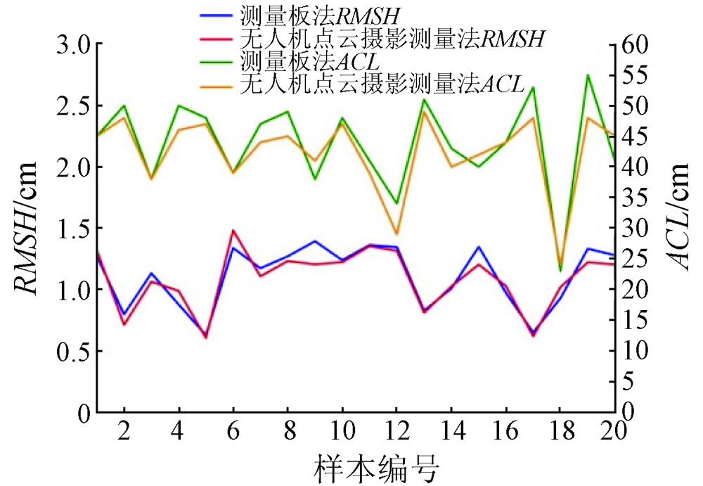
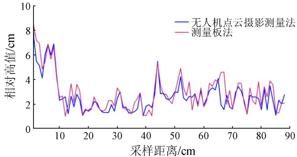
Abstract The soil roughness of cultivated land is an important element affecting the monitoring of agricultural information, such as soil moisture, microwave remote sensing observation, and plant growth. Soil roughness is generally interpreted according to field photos. However, such interpretation suffers some shortcomings such as low efficiency and anthropogenic effects on processing results. UAV low-altitude remote sensing is sensitive to surface relief. To explore the precision of the soil roughness determined using UAV data, this study employed UAV photogrammetry to photograph the surface and then compared the photogrammetry results with the data obtained using a gauging plate for soil roughness. The results show that the close-range photogrammetry had mean absolute errors of mainly 0.4~1.2 cm, a mean relative error of 6.16%, and a root mean square error of 0.40 cm. Therefore, UAV-based point cloud photogrammetry could be effectively applied to the measurement of surface roughness, and a smaller sampling area is associated with more accurate soil roughness.
|
| Keywords
soil roughness
point cloud data
close-range photogrammetry
three-dimensional modeling
|
|
|
|
Issue Date: 20 March 2023
|
|
|
| [1] |
徐元柳. 基于裸露地表辐射传输模型的粗糙度反演与地形校正[D]. 北京: 中国地质大学(北京), 2009:45-53.
|
| [1] |
Xu Y L. Roughness retrieval and topographic correction based on bare surface radiative transfer model[D]. Beijing: China University of Geosciences(Beijing), 2009:45-53.
|
| [2] |
江冲亚, 方红亮, 魏珊珊. 地表粗糙度参数化研究综述[J]. 地球科学进展, 2012, 27(3):292-303.
|
| [2] |
Jiang C Y, Fang H L, Wei S S. Review of land surface roughness parameterization study[J]. Advances in Earth Science, 2012, 27(3):292-303.
|
| [3] |
姜灵海. 基于哨兵数据的土壤水分反演算法研究[D]. 成都: 电子科技大学, 2020.
|
| [3] |
Jiang L H. Research on soil moisture retreval based on Sentinel data[D]. Chengdu: University of Electronic Science and Technology of China, 2020.
|
| [4] |
梁勇, 杨磊, 吴秋兰, 等. 地表粗糙度影响下的GNSS-R土壤湿度反演仿真分析[J]. 武汉大学学报(信息科学版), 2018, 43(10):1546-1552.
|
| [4] |
Liang Y, Yang L, Wu Q L, et al. Simulation of soil roughness impact in GNSS-R soil moisture retrieval[J]. Geomatics and Information Science of Wuhan University, 2018, 43(10):1546-1552.
|
| [5] |
Alvarez-Mozos J, Verhoest N E, Larranaga A, et al. Influence of surface roughness spatial variability and temporal dynamics on the retrieval of soil moisture from SAR observations[J]. Sensors (Basel), 2009, 9(1):463-489.
doi: 10.3390/s90100463
url: http://www.mdpi.com/1424-8220/9/1/463
|
| [6] |
陈世超, 林剑辉, 孙宇瑞, 等. 基于土壤表面粗糙度预测降雨影响下的表层土壤孔隙度[J]. 北京林业大学学报, 2013, 35(2):69-74.
|
| [6] |
Chen S C, Lin J H, Sun Y R, et al. Predicting topsoil porosity using soil surface roughness under rainfall influence[J]. Journal of Beijing Forestry University, 2013, 35(2):69-74.
|
| [7] |
Darboux F, Gascuelodoux C, Davy P. Effects of surface water storage by soil roughness on overland-flow generation[J]. Earth Surface Processes and Landforms, 2010, 27(3):223-233.
doi: 10.1002/esp.v27:3
url: http://doi.wiley.com/10.1002/esp.v27%3A3
|
| [8] |
García Moreno R, et al.Díaz Álvarez M C,Saa Requejo A, Multifractal analysis of soil surface roughness[J]. Vadose Zone Journal, 2008, 7(2):512-520.
doi: 10.2136/vzj2007.0016
url: http://doi.wiley.com/10.2136/vzj2007.0016
|
| [9] |
Thomsen L M, Baartman J E M, Barneveld R J, et al. Soil surface roughness:Comparing old and new measuring methods and application in a soil erosion model[J]. Soil, 2015, 1(1):399-400.
doi: 10.5194/soil-1-399-2015
url: https://soil.copernicus.org/articles/1/399/2015/
|
| [10] |
Riegler-Nurscher P, Moitzi G, Prankl J, et al. Machine vision for soil roughness measurement and control of tillage machines during seedbed preparation[J]. Soil and Tillage Research, 2020, 196:104351.
doi: 10.1016/j.still.2019.104351
url: https://linkinghub.elsevier.com/retrieve/pii/S0167198719300613
|
| [11] |
Robichaud P R, Molnau M. Measuring soil roughness changes with an ultrasonic profiler[J]. Transactions of the ASAE, 1990, 33(6):1851-1858.
doi: 10.13031/2013.31549
url: http://elibrary.asabe.org/abstract.asp??JID=3&AID=31549&CID=t1990&v=33&i=6&T=1
|
| [12] |
陶浩然, 陈权, 李震, 等. 近景摄影测量提高裸露地表粗糙度测量精度[J]. 农业工程学报, 2017, 33(15):162-167.
|
| [12] |
Tao H R, Chen Q, Li Z, et al. Improvement of soil surface roughness measurement accuracy by close-range photogrammetry[J]. Transactions of the Chinese Society of Agricultural Engineering, 2017, 33(15):162-167.
|
| [13] |
蔡祥, 孙宇瑞, 林剑辉, 等. 基于激光反射的土壤表面粗糙度测量装置设计与试验[J]. 农业机械学报, 2010, 41(1):68-69.
|
| [13] |
Cai X, Sun Y R, Lin J H, et al. Design of a laser scanner for characterizing soil surface roughness[J]. Transactions of the Chinese Society for Agricultural Machinery, 2010, 41(1):68-69.
|
| [14] |
王章琼, 白俊龙, 张明. 数码摄影测量及三维建模在岩体结构面粗糙度教学中的应用[J]. 实验技术与管理, 2020, 37(3):45-47.
|
| [14] |
Wang Z Q, Bai J L, Zhang M. Application of digital photogrammetry and 3D modeling in teaching of rock discontinuity surface roughness[J]. Experimental Technology and Management, 2020, 37(3):45-47.
|
| [15] |
王洪晓, 张光辉, 朱平宗, 等. 3种地表随机糙率测量方法比较[J]. 水土保持研究, 2020, 27(4):72-76.
|
| [15] |
Wang H X, Zhang G H, Zhu P Z, et al. Comparison of three metho-ds to measure surface random roughness[J]. Journal of Soil and Water Conservation, 2020, 27(4):72-76.
|
| [16] |
张胜宾, 黄培奎, 赵祚喜. 土壤表面粗糙度检测方法研究[J]. 农机化研究, 2016, 38(11):257-262.
|
| [16] |
Zhang S B, Huang P K, Zhao Z X. A research on soil surface roughness measurement methods[J]. Journal of Agricultural Mechanization Research, 2016, 38(11):257-262.
|
| [17] |
李红阳. 基于无人机摄影测量技术的土地调查方法研究[D]. 唐山: 华北理工大学, 2018.
|
| [17] |
Li H Y. The research method of land survey based on UAV photogrammetry techology[D]. Tangshan: North China University of Science and Technology, 2018.
|
| [18] |
李德仁, 李明. 无人机遥感系统的研究进展与应用前景[J]. 武汉大学学报(信息科学版), 2014, 39(5):505-512.
|
| [18] |
Li D R, Li M. Research progress and application prospect of UAV remote sensing system[J]. Geomatics and Information Science of Wuhan University, 2014, 39(5):505-512.
|
| [19] |
Warner W S. Mapping a three-dimensional soil surface with hand-held 35 mm photography[J]. Soil and Tillage Research, 1995, 34(3):187-197.
doi: 10.1016/0167-1987(95)00462-2
url: https://linkinghub.elsevier.com/retrieve/pii/0167198795004622
|
| [20] |
许元红. 低空无人机技术在贵州山区大比例尺DLG制作中的应用研究[D]. 贵阳: 贵州师范大学, 2018:1-8.
|
| [20] |
Xu Y H. The application of low-altitude drone thchnology in the production of large scale DLG in Guizhou mountain area[D]. Guiyang: Guizhou Normal University, 2018:1-8.
|
| [21] |
胡玉祥, 张洪德, 熊文辉, 等. 基于三维激光点云的地表竣工规划验收测绘级工程应用[J]. 测绘通报, 2020(s1):53-58.
|
| [21] |
Hu Y X, Zhang H D, Xiong W H, et al. Survey and engineering application of metro completion plan acceptance based on 3D laser point cloud[J]. Bulletin of Surveying and Mapping, 2020(s1):53-58.
|
| [22] |
尹林江, 周忠发, 李韶慧, 等. 基于无人机可见光影像对喀斯特地区植被信息提取与覆盖度研究[J]. 草地学报, 2020, 28(6):1664-1672.
doi: 10.11733/j.issn.1007-0435.2020.06.021
|
| [22] |
Yin L J, Zhou Z F, Li S H, et al. Research on vegetation extraction and fractional vegetation cover of Karst area based on visible light image of UAV[J]. Acta Agrestia Sinica, 2020, 28(6):1664-1672.
|
| [23] |
冯静静. 基于LiDAR点云数据与高分辨率影像的单木参数提取[D]. 北京: 北京林业大学, 2017:1-5.
|
| [23] |
Feng J J. Single tree parameter extraction based on LiDAR point cloud data and high resolution image[D]. Beijing: Beijing Forestry University, 2017:1-5.
|
| [24] |
赵勋, 岳彩荣, 李春干, 等. 基于机载LiDAR点云数据森林郁闭度估测[J]. 遥感技术与应用, 2020, 35(5):1136-1145.
|
| [24] |
Zhao X, Yue C R, Li C G, et al. Canopy density estimation based on airborne LiDAR point cloud data[J]. Remote Sensing Technolo-gy and Application, 2020, 35(5):1136-1145.
|
| [25] |
姜云, 王军, 陈方圆. 黑土区大田尺度下LiDAR点云数据农作物种植区提取[J]. 测绘工程, 2020, 29(4):32-37.
|
| [25] |
Jiang Y, Wang J, Chen F Y. Extraction of paddy planting area based on LiDAR point cloud data at field-scale in black soil area[J]. Engineering of Surveying and Mapping, 2020, 29(4):32-37.
|
| [26] |
段平, 李佳, 李海坤, 等. 无人机影像点云与地面激光点云匹配的三维建模方法[J]. 测绘工程, 2020, 29(4):44-47.
|
| [26] |
Duan P, Li J, Li H K, et al. 3D modeling method of UAV image point cloud matching with ground laser point cloud[J]. Engineering of Surveying and Mapping, 2020, 29(4):44-47.
|
| [27] |
刘洁, 杨晓菊, 廖宜涛, 等. 基于线结构激光传感器的土壤表面粗糙度测量方法研究[J]. 农业工程学报, 2019, 35(3):134-138.
|
| [27] |
Liu J, Yang X J, Liao Y T, et al. Study on soil surface roughness measurement method based on linear laser sensor[J]. Transactions of the Chinese Society of Agricultural Engineering, 2019, 35(3):134-138.
|
| [28] |
罗达, 林杭生, 金钊, 等. 无人机数字摄影测量与激光雷达在地形地貌与地表覆盖研究中的应用及比较[J]. 地球环境学报, 2018, 10(3):215-222.
|
| [28] |
Luo D, Lin H S, Jin Z, et al. Application and comparison of UAV digital photogrammetry and LiDAR in topography and land cover research[J]. Journal of Earth Environment, 2018, 10(3):215-222.
|
| [29] |
Verhoeven G. Taking computer vision aloft-archaeological three-dimensional reconstructions from aerial photographs with PhotoScan[J]. Archaeological Prospection, 2011, 18(1):67-73.
doi: 10.1002/arp.v18.1
url: http://doi.wiley.com/10.1002/arp.v18.1
|
| [30] |
Remondino F, El-Hakim S. Image-based 3D modelling:A review[J]. Photogrammetric Record, 2010, 21(115):269-291.
doi: 10.1111/(ISSN)1477-9730
url: http://doi.wiley.com/10.1111/%28ISSN%291477-9730
|
| [31] |
Tavani S, Granado P, Corradetti A, et al. Building a virtual outcrop,extracting geological information from it,and sharing the results in Google Earth via OpenPlot and Photoscan:An example from the Khaviz Anticline (Iran)[J]. Computers and Geosciences, 2014, 63:44-53.
doi: 10.1016/j.cageo.2013.10.013
url: https://linkinghub.elsevier.com/retrieve/pii/S009830041300277X
|
| [32] |
柴子为, 康峻, 王力, 等. 基于无人机影像的山地人工林景观DEM构建[J]. 遥感技术与应用, 2015, 30(3):504-509.
|
| [32] |
Cai Z W, Kang J, Wang L, et al. Construction of mountain plantation landscape DEM based on UAV image[J]. Remote Sensing Technology and Application, 2015, 30(3):504-509.
|
| [33] |
行敏锋, 黄方, 官雨薇. 基于图像处理的土壤表面粗糙度测量实验研究[J]. 实验科学与技术, 2019, 17(6):1-3.
|
| [33] |
Xing M F, Huang F, Guan Y W. Experimental study on measurement of soil surface roughness based on image processing[J]. Experiment Science and Technology, 2019, 17(6):1-3.
|
| [34] |
刘立超, 魏国梁, 张青松, 等. 基于激光雷达的农业耕作微地貌测量装置设计与实验[J]. 农业机械学报, 2019, 50(7):85-91.
|
| [34] |
Liu L C, Wei G L, Zhang Q S, et al. Design and experiment of agricultural microgeomorphology measuring device based on LiDAR[J]. Transactions of the Chinese Society for Agricultural Machinery, 2019, 50(7):85-91.
|
| [35] |
雷志斌. 基于高分三号雷达数据的作物覆盖区土壤水分反演研究[D]. 北京. 中国地质大学(北京), 2020:18-20.
|
| [35] |
Lei Z B. Research on soil moisture retrieval of crop covering area based on GaoFen3 Radar data[D]. Beijing: China University of Geosciences(Beijing), 2020:18-20.
|
| [36] |
李俐, 王荻, 潘彩霞, 等. 基于神经网络与决策树的土壤粗糙度测量[J]. 农业工程学报, 2015, 31(14):132-138.
|
| [36] |
Li L, Wang D, Pan C X, et al. Soil surface roughness measuring method based on neural network and decision tree[J]. Transactions of the Chinese Society of Agricultural Engineering, 2015, 31(14):132-138.
|
| [37] |
张恒瑞, 段喜明, 魏征, 等. 基于无人机多光谱遥感的华北地区夏玉米LAI监测[J]. 山西农业科学, 2021, 49(5):608-614.
|
| [37] |
Zhang H R, Duan X M, Wei Z, et al. LAI monitoring of summer maize in North China based on UAV multi-spectral remote sensing[J]. Journal of Shanxi Agricultural Sciences, 2021, 49(5):608-614.
|
| [38] |
郑兴明, 赵凯, 李晓洁. 农田表面粗糙度参数的测量与精度分析[J]. 地球信息科学学报, 2013, 15(5):753-755.
|
| [38] |
Zheng X M, Zhao K, Li X J. Accuracy analysis of agriculture soil surface roughness parameter[J]. Journal of Geo-Information Science, 2013, 15(5):753-755.
|
| [39] |
Kim S B, Moghaddam M, Tsang L, et al. Models of L-band Radar backscattering coefficients over global rain for soil moisture retrieval[J]. IEEE Transactions on Geoscience and Remote Sensing, 2014, 52(2):1381-1396.
doi: 10.1109/TGRS.2013.2250980
url: http://ieeexplore.ieee.org/document/6515383/
|
|
Viewed |
|
|
|
Full text
|
|
|
|
|
Abstract
|
|
|
|
|
Cited |
|
|
|
|
| |
Shared |
|
|
|
|
| |
Discussed |
|
|
|
|
 2023,
Vol. 35
2023,
Vol. 35