|
|
 |
|

|
|
|
Extracting granite pegmatite information based on GF-2 images and the random forest algorithm |
DU Xiaochuan1,2( ), LOU Debo2(), XU Lingang1, FAN Yinglin1,2, ZHANG Lin1, LI Wanyue1,2 ), LOU Debo2(), XU Lingang1, FAN Yinglin1,2, ZHANG Lin1, LI Wanyue1,2 |
1. School of Earth Sciences and Resources, China University of Geosciences (Beijing), Beijing 100083, China
2. MNR Key Laboratory of Metallogeny and Mineral Assessment, Institute of Mineral Resources, Chinese Academy of Geological Sciences, Beijing 100037, China |
|
|
|
|
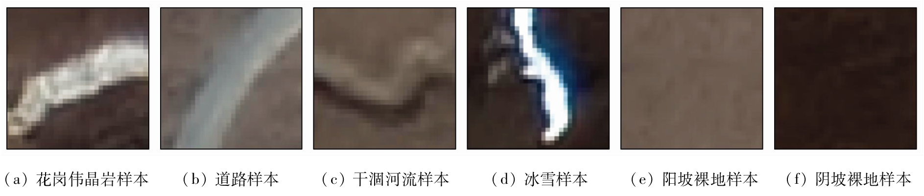
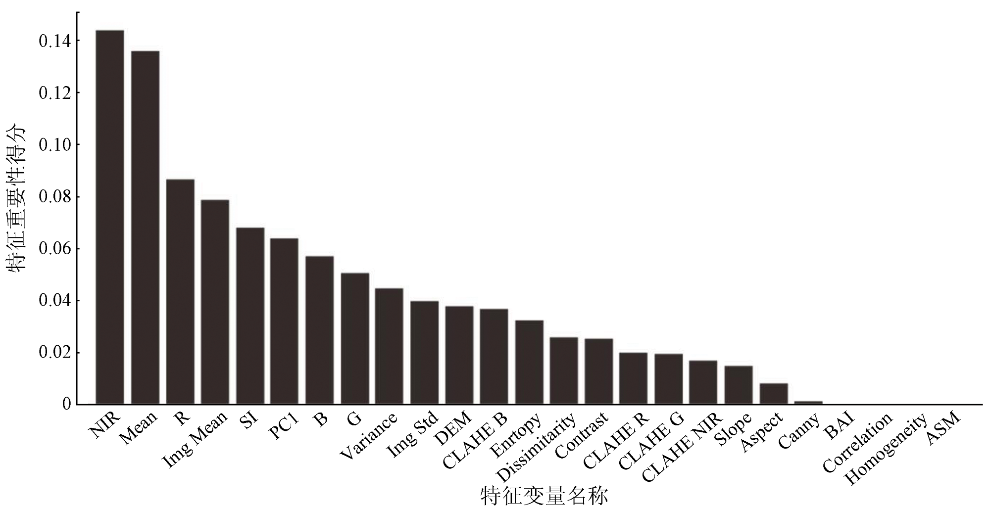
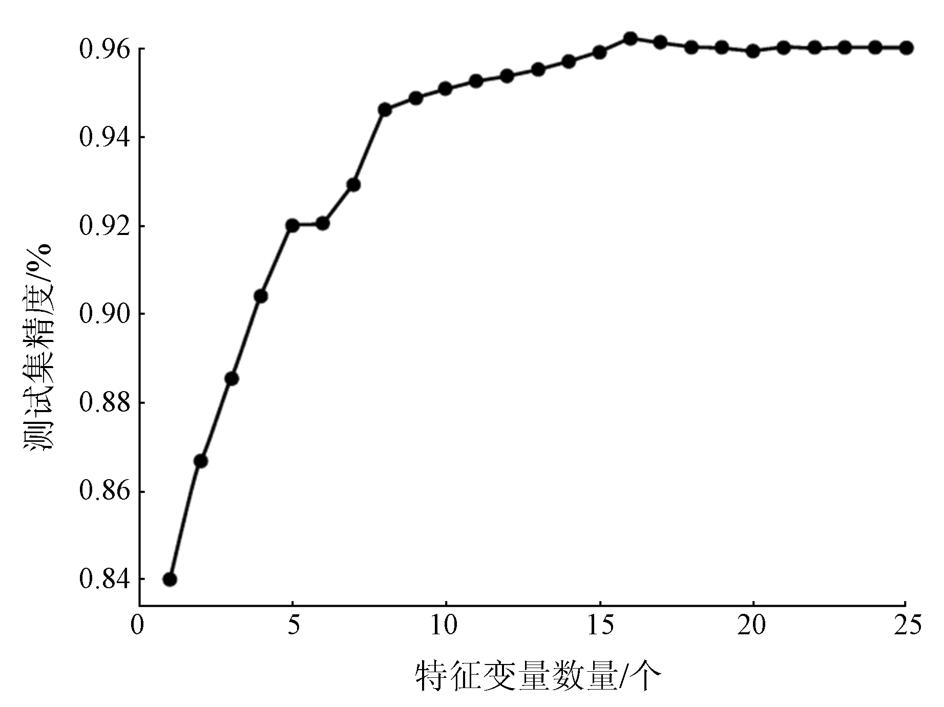
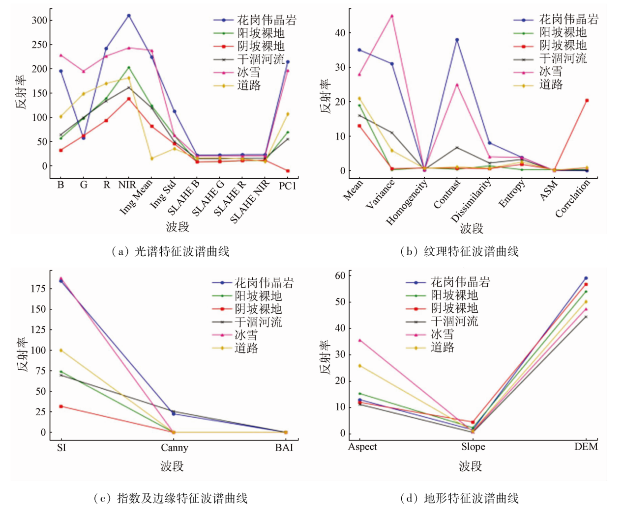
Abstract Granite pegmatites serve as a significant carrier and prospecting marker of granite pegmatite-type lithium deposits. The southeastern Zhaka area in Tianjun County, Qinghai Province demonstrates considerable prospecting potential for lithium deposits. Nevertheless, its high altitudes and deep cross-cutting characteristics pose challenges in surface surveys. Hence, this study extracted the granite pegmatite information within the study area from remote sensing images using the random forest algorithm. With high-spatial-resolution GF-2 remote sensing images as the primary data source, it extracted the spectral, texture, exponential, topographic, and edge features from various ground objects within the study area. These features, together with the newly introduced contrast limited adaptive histogram equalization (CLAHE) features, constituted 25 feature variables, forming a feature subset. Then, feature variables in the subset were evaluated for their feature importance, and their importance scores were used for feature selection, determining the optimal feature combination for extracting granite pegmatite information. Ultimately, 16 feature variables were chosen for random forest classification, with the accuracy of the classification results assessed. The study indicates that: ①The CLAHE feature variables emphasize the tonal variations among ground objects, thereby enhancing the classification accuracy, with the overall accuracy increased by 2.7 percentage points and the Kappa coefficient increased by 0.035; ②The classification results for granite pegmatites based on GF-2 images and the random forest algorithm exhibited overall accuracy of 93.1%, with a Kappa coefficient of 0.902, user accuracy of 94.24%, and producer accuracy of 98.00%, confirming the effectiveness of the method used in this study. Moreover, this study provides reliable data for future research in the study area.
|
| Keywords
granite pegmatite
random forest algorithm
CLAHE
feature importance
Qinghai Province
|
|
|
|
Issue Date: 21 December 2023
|
|
|
| [1] |
王登红. 关键矿产的研究意义、矿种厘定、资源属性、找矿进展、存在问题及主攻方向[J]. 地质学报, 2019, 93(6):1189-1209.
|
| [1] |
Wang D H. Study on critical mineral resources:Signficance of research,determiniation of types,attributes of resources,progress of prospecting,problems of utilization,and direction of exploitation[J]. Acta Geologica Sinica, 2019, 93(6):1189-1209.
|
| [2] |
王学求, 刘汉粮, 王玮, 等. 中国锂矿地球化学背景与空间分布:远景区预测[J]. 地球学报, 2020, 41(6):797-806.
|
| [2] |
Wang X Q, Liu H L, Wang W, et al. Geochemical abundance and spatial distribution of lithium in China:Implications for potential prospects[J]. Acta Geoscientica Sinica, 2020, 41(6):797-806.
|
| [3] |
唐军. 浅析典型伟晶岩型锂矿床成矿地质特征[J]. 世界有色金属, 2020(14):143-144.
|
| [3] |
Tang J. A brief analysis of metallogenic characteristics of typical pegmatite type lithium deposits[J]. World Nonferrous Metals, 2020(14):143-144.
|
| [4] |
姚佛军, 徐兴旺, 杨建民, 等. 戈壁浅覆盖区花岗岩中锂铍伟晶岩的ASTER遥感识别技术——以新疆镜儿泉地区为例[J]. 矿床地质, 2020, 39(4):686-696.
|
| [4] |
Yao F J, Xu X W, Yang J M, et al. A technology for identifying Li-Be pegmatite using ASTER remote sensing data in granite of Gobi shallow-covered area:A case study of recognition and prediction of Li-Be pegmatite in Jingerquan,Xinjiang[J]. Mineral Deposits, 2020, 39(4):686-696.
|
| [5] |
代晶晶, 王登红, 代鸿章, 等. 遥感技术在川西甲基卡大型锂矿基地找矿填图中的应用[J]. 中国地质, 2017, 44(2):389-398.
|
| [5] |
Dai J J, Wang D H, Dai H Z, et al. Geological mapping and ore-prospecting study using remote sensing technology in Jiajika area of Western Sichuan Province[J]. Geology in China, 2017, 44(2):389-398.
|
| [6] |
代晶晶, 王登红, 代鸿章, 等. 川西甲基卡锂矿基地典型岩石及矿物反射波谱特征研究[J]. 岩矿测试, 2018, 37(5):507-517.
|
| [6] |
Dai J J, Wang D H, Dai H Z, et al. Reflectance spectral characteristics of rocks and minerals in Jiajika lithium deposits in West Sichuan[J]. Rock and Mineral Analysis, 2018, 37(5):507-517.
|
| [7] |
Cardoso-Fernandes J, Teodoro A C, Lima A. Remote sensing data in lithium (Li) exploration:A new approach for the detection of Li-bearing pegmatites[J]. International Journal of Applied Earth Observation and Geoinformation, 2019, 76:10-25.
doi: 10.1016/j.jag.2018.11.001
url: https://linkinghub.elsevier.com/retrieve/pii/S0303243418309474
|
| [8] |
王海宇. 基于深度语义分割的遥感影像伟晶岩脉信息提取研究[D]. 北京: 中国地质大学(北京), 2021.
|
| [8] |
Wang H Y. Research on extracting pegmatite dike information of remote sensing image based on depth semantic segmentation[D]. Beijing: China University of Geosciences(Beijing), 2021.
|
| [9] |
Verikas A, Gelzinis A, Bacauskiene M. Mining data with random forests:A survey and results of new tests[J]. Pattern Recognition, 2011, 44(2):330-349.
doi: 10.1016/j.patcog.2010.08.011
url: https://linkinghub.elsevier.com/retrieve/pii/S0031320310003973
|
| [10] |
王书玉, 张羽威, 于振华. 基于随机森林的洪河湿地遥感影像分类研究[J]. 测绘与空间地理信息, 2014, 37(4):83-85,93.
|
| [10] |
Wang S Y, Zhang Y W, Yu Z H. Classification of Honghe wetland remote sensing image based on random forests[J]. Geomatics & Spatial Information Technology, 2014, 37(4):83-85,93.
|
| [11] |
Dronova I. Object-based image analysis in wetland research:A review[J]. Remote Sensing, 2015, 7(5):6380-6413.
doi: 10.3390/rs70506380
url: http://www.mdpi.com/2072-4292/7/5/6380
|
| [12] |
陈海洋, 孟令奎, 周元. 基于随机森林的遥感影像雪冰云信息检测方法[J]. 测绘地理信息, 2022, 47(2):105-110.
|
| [12] |
Chen H Y, Meng L K, Zhou Y. Ice snow and cloud detection in remote sensing images based on random forest[J]. Journal of Geomatics, 2022, 47(2):105-110.
|
| [13] |
Feng Q, Liu J, Gong J. UAV remote sensing for urban vegetation mapping using random forest and texture analysis[J]. Remote Sensing, 2015, 7(1):1074-1094.
doi: 10.3390/rs70101074
url: http://www.mdpi.com/2072-4292/7/1/1074
|
| [14] |
Dell'Acqua F, Gamba P. Texture-based characterization of urban environments on satellite SAR images[J]. IEEE Transactions on Geoscience and Remote Sensing, 2003, 41(1):153-159.
doi: 10.1109/TGRS.2002.807754
url: http://ieeexplore.ieee.org/document/1183703/
|
| [15] |
Stasolla M, Gamba P. Spatial indexes for the extraction of formal and informal human settlements from high-resolution SAR images[J]. IEEE Journal of Selected Topics in Applied Earth Observations and Remote Sensing, 2008, 1(2):98-106.
doi: 10.1109/JSTARS.4609443
url: https://ieeexplore.ieee.org/xpl/RecentIssue.jsp?punumber=4609443
|
| [16] |
Feng Q, Gong J, Liu J, et al. Flood mapping based on multiple endmember spectral mixture analysis and random forest classifier:The case of Yuyao,China[J]. Remote Sensing, 2018, 7(9):12539-12562.
doi: 10.3390/rs70912539
url: http://www.mdpi.com/2072-4292/7/9/12539
|
| [17] |
Ali A, Pour A. Lithological mapping and hydrothermal alteration using Landsat 8 data:A case study in ariab mining district,red sea hills,Sudan[J]. International Journal of Sciences Basic and Applied Sciences, 2014, 3(3):199-208.
|
| [18] |
郭霞. 基于Landsat-8 OLI遥感数据的随机森林分类优化研究[D]. 秦皇岛: 燕山大学, 2021.
|
| [18] |
Guo X. Optimization research of random forest classification based on Landsat-8 OLI remote sensing images[D]. Qinghuangdao: Yanshan University, 2021.
|
| [19] |
刘念. 基于坎尼边缘检测算法的遥感影像自动绘图研究[J]. 测绘地理信息, 2016, 41(6):75-78.
|
| [19] |
Liu N. Automatic mapdrawing of remote sensing images based on Canny edge detection algorithm[J]. Journal of Geomatics, 2016, 41(6):75-78.
|
| [20] |
Breiman L. Random forests[J]. Machine Learning, 2001, 45(1):5-32.
doi: 10.1023/A:1010933404324
url: http://link.springer.com/10.1023/A:1010933404324
|
| [21] |
张佳华, 姚宜斌, 曹娜. 基于决策树对有无降水进行预测[J]. 测绘地理信息, 2017, 42(5):107-109.
|
| [21] |
Zhang J H, Yao Y B, Cao N. Prediction of whether precipitation based on decision tree[J]. Journal of Geomatics, 2017, 42(5):107-109.
|
| [22] |
Lerman P M. Fitting segmented regression models by grid search[J]. Journal of the Royal Statistical Society:Series C(Applied Statistics), 1980, 29(1):77-84.
|
| [23] |
陈红星. 基于多源数据和随机森林算法的建筑物尺度人口估算[D]. 上海: 华东师范大学, 2021.
|
| [23] |
Chen H X. Population estimation at the building level based on multi-source data and random forest algorithm[D]. Shanghai: East China Normal University, 2021.
|
| [24] |
黄东山. 特征选择及半监督分类方法研究[D]. 武汉: 华中科技大学, 2011.
|
| [24] |
Huang D S. Research on feature selection and semi-supervised classification[D]. Wuhan: Huazhong University of Science and Technology, 2011.
|
| [25] |
袁帅, 杨宏晖, 申昇. 基于互信息的顺序向前特征选择算法[J]. 声学技术, 2014, 33(4):359-362.
|
| [25] |
Yuan S, Yang H H, Shen S. Forward order feature selection algorithm based on mutual information[J]. Technical Acoustics, 2014, 33(4):359-362.
|
|
Viewed |
|
|
|
Full text
|
|
|
|
|
Abstract
|
|
|
|
|
Cited |
|
|
|
|
| |
Shared |
|
|
|
|
| |
Discussed |
|
|
|
|
 2023,
Vol. 35
2023,
Vol. 35