|
|
 |
|

|
|
|
Application and analysis of ZY1-02D hyperspectral data in geological and mineral survey |
LI Genjun1,2( ), YANG Xuesong1,2(), ZHANG Xing1,2, LI Xiaomin1,2, LI Delin1,2, DU Cheng1,2 ), YANG Xuesong1,2(), ZHANG Xing1,2, LI Xiaomin1,2, LI Delin1,2, DU Cheng1,2 |
1. Key Laboratory of Geological Processes and Mineral Resources of the Northern Qinghai-Tibet Plateau in Qinghai Province, Xining 810012, China
2. Qinghai Geological Survey, Xining 810012, China |
|
|
|
|
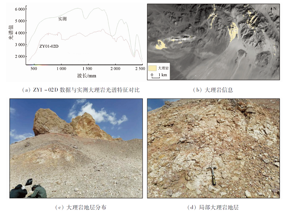
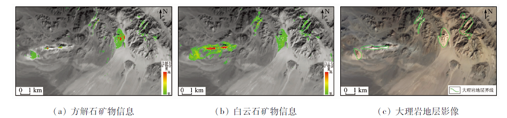
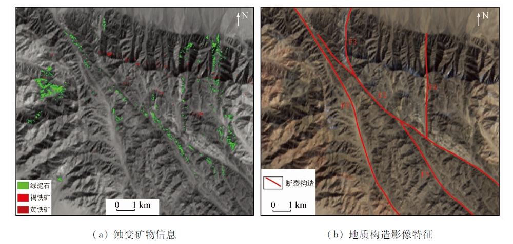
Abstract The ZY1-02D satellite is the first hyperspectral operational satellite in China. To test the application ability of ZY1-02D hyperspectral loading data in geological and mineral survey, the authors identified lithologic and mineral information on the basis of data pre-processing, and the results were compared with GF-5 data. The application ability of the data was analyzed effectively in combination with the results of field survey. The results are as follows: the coincidence degree of ZY1-02D hyperspectral data reflectivity spectrum curve and geological body spectrum curve is high in shape, which can meet the requirements of rock and mineral information identification; through the identification of rock and mineral information in combination with the geological and mineral data of the study area, it is shown that the lithological information of marble, monzogranite, calcite and dolomite and alteration mineral information of chlorite and limonite are consistent with the measured results. The results show that the data has good recognition effect on the information of rocks and minerals, and can provide data guarantee for the application of hyperspectral technology in the field of geology and mineral exploration.
|
| Keywords
spectral characteristic
geological and mineral survey
application analysis
ZY1-02D data
east area of Lenghu Town in Qinghai Province
|
|
|
|
Corresponding Authors:
YANG Xuesong
E-mail: ligenjun2008@163.com;455132796@qq.com
|
|
Issue Date: 21 July 2021
|
|
|
| [1] |
方洪宾, 刘顺喜, 杨清华, 等. CBERS-02B星在轨测试数据国土资源应用评价[J]. 国土资源遥感, 2009, 21(1):33-47.doi: 10.6046/gtzyyg.2009.01.09.
doi: 10.6046/gtzyyg.2009.01.09
|
| [1] |
Fang H B, Liu S X, Yang Q H, et al. An application evaluation of the CBERS-02B satellite on orbit image data for land and resources[J]. Remote Sensing for Land and Resources, 2009, 21(1):33-47.doi: 10.6046/gtzyyg.2009.01.09.
doi: 10.6046/gtzyyg.2009.01.09
|
| [2] |
马熹肇. 资源一号“02C”卫星数据在轨测试分析[D]. 长春:吉林大学, 2012.
|
| [2] |
Ma X Z. Data analysis on in-orbit testing of Ziyuan 1-02C Satellite[D]. Changchun:Jilin University, 2012.
|
| [3] |
璀璨. 基于对比分析的国产卫星影像质量评价[D]. 长春:吉林大学, 2014.
|
| [3] |
Cui C. The quality assessment of domestic satellite images based on contrestive analysis[D]. Changchun:Jilin University, 2014.
|
| [4] |
朱裕生, 肖克炎, 宋国耀, 等. 中国主要成矿区(带)成矿地质特征及矿床成矿谱系[M]. 北京: 地质出版社, 2007.
|
| [4] |
Zhu Y S, Xiao K Y, Song G Y, et al. Geological feature and metallogedigree of ore deposits in the major metallogenic regions(belts)in China[M]. Beijing: Geological Publishing House, 2007.
|
| [5] |
王茂之. 高光谱遥感影像处理与地质应用若干关键问题研究[D]. 成都:成都理工大学, 2014.
|
| [5] |
Wang M Z. Researches on several critical problems of hyperspectral remote sensing image processing and geologic application[D]. Chengdu:Chengdu University of Technology, 2014.
|
| [6] |
郭帮杰. 准噶尔盆地东缘铀及多金属勘查高光谱遥感应用研究[D]. 北京:核工业北京地质研究院, 2016.
|
| [6] |
Guo B J. Hyperspectral remote sensing applications for uranium and polymetallic exploration in the eastern margin of the Dzungar basin[D]. Beijing:Beijing Research Institute of Uranium Geology, 2016.
|
| [7] |
芶盛. 高光谱遥感图像光谱特征提取与匹配技术研究[D]. 成都:成都理工大学, 2011.
|
| [7] |
Gou S. Spectral feature extraction and matching research on hyper-spectral remote sensing image[D]. Chengdu:Chengdu University of Technology, 2011.
|
| [8] |
甘甫平, 董新丰, 闫柏琨, 等. 光谱地质遥感研究进展[J]. 南京信息工程大学学报(自然科学版), 2018, 10(1):44-62.
|
| [8] |
Gan F P, Dong X F, Yan B K, et al. Research progress of spectrometry geological remote sensing[J]. Journal of Nanjing University of Information Science Technology(Natural Science Edition), 2018, 10(1):44-62.
|
| [9] |
童庆禧, 张兵, 张立福. 中国高光谱遥感的前沿进展[J]. 遥感学报, 2016, 20(5):689-707.
|
| [9] |
Tong Q X, Zhang B, Zhang L F. Current progress of hyperspectral remote sensing in China[J]. Journal of Remote Sensing, 2016, 20(5):689-707.
|
| [10] |
梁树能, 甘甫平, 闫柏琨, 等. 白云母矿物成分与光谱特征的关系研究[J]. 国土资源遥感, 2012, 24(3):111-115.doi: 10.6046/gtzyyg.2012.03.20.
doi: 10.6046/gtzyyg.2012.03.20
|
| [10] |
Liang S N, Gan F P, Yan B K, et al. Relationship between composition and spectral feature of muscovite[J]. Remote Sensing for Land and Resources, 2012, 24(3):111-115.doi: 10.6046/gtzyyg.2012.03.20.
doi: 10.6046/gtzyyg.2012.03.20
|
| [11] |
梁树能, 甘甫平, 闫柏琨, 等. 绿泥石矿物成分与光谱特征的关系研究[J]. 光谱学与光谱分析, 2014(7):1763-1768.
|
| [11] |
Liang S N, Gan F P, Yan B K, et al. A study on the relationship between the composition and spectral feature parameters in chlorite[J]. Spectroscopy and Spectral Analysis, 2014(7):1763-1768.
|
| [12] |
樊磊. 基于对应分析的变质岩地区高光谱遥感岩性分类[D]. 北京:首都师范大学, 2013.
|
| [12] |
Fan L. Classification of metamorphic rocks by hyperspectral remote sensing based on correspondence analysis[D]. Beijing:Capital Normal University, 2013.
|
| [13] |
肖滋泽. 新疆雅满苏地区高光谱遥感地质解译及找矿预测研究[D]. 昆明:昆明理工大学, 2015.
|
| [13] |
Xiao Z Z. Study on geological interpretation of hyperspectral remote sensing and prospecting prediction in Yamansu area in Xinjiang[D]. Kunming:Kunming University of Science and Technology, 2015.
|
| [14] |
张国亮. 新疆北山地区与云南普朗铜矿高光谱岩矿信息提取研究[D]. 长春:吉林大学, 2017.
|
| [14] |
Zhang G L. Research on extraction of rocks and minerals information from hyperspectral data in Beishan area of Xinjiang and Pulang copper deposit of Yunnan[D]. Changchun:Jilin University, 2017.
|
| [15] |
徐清俊. 新疆白杨河铀矿床高光谱遥感蚀变特征研究[D]. 北京:核工业北京地质研究院, 2016.
|
| [15] |
Xu Q J. Study on hyperspectral remote sensing alteration characteristics of Baiyanghe uranium deposit in Xinjiang[D]. Beijing:Beijing Research Institute of Uranium Geology, 2016.
|
| [16] |
徐元进. 面向找矿的高光谱遥感岩矿信息提取方法研究[D]. 武汉:中国地质大学, 2009.
|
| [16] |
Xu Y J. Research of prospecting-oriented approachesto information extraetionof rocksand minerals using hyperspectral remote sensing data[D]. Wuhan:China University of Geoscienees, 2009.
|
|
Viewed |
|
|
|
Full text
|
|
|
|
|
Abstract
|
|
|
|
|
Cited |
|
|
|
|
| |
Shared |
|
|
|
|
| |
Discussed |
|
|
|
|
 2021,
Vol. 33
2021,
Vol. 33