|
|
|
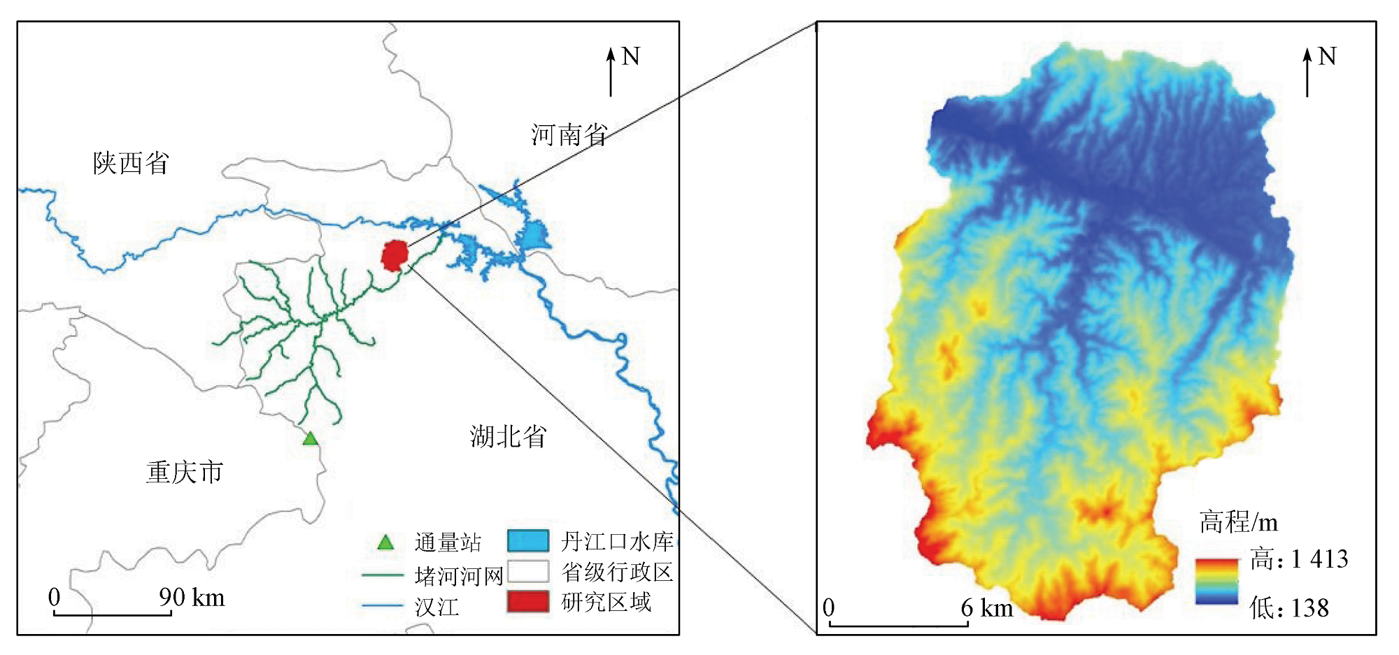
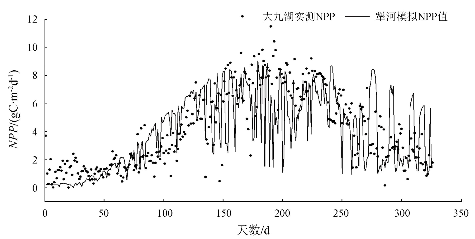
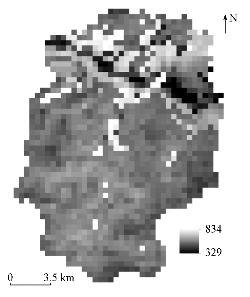
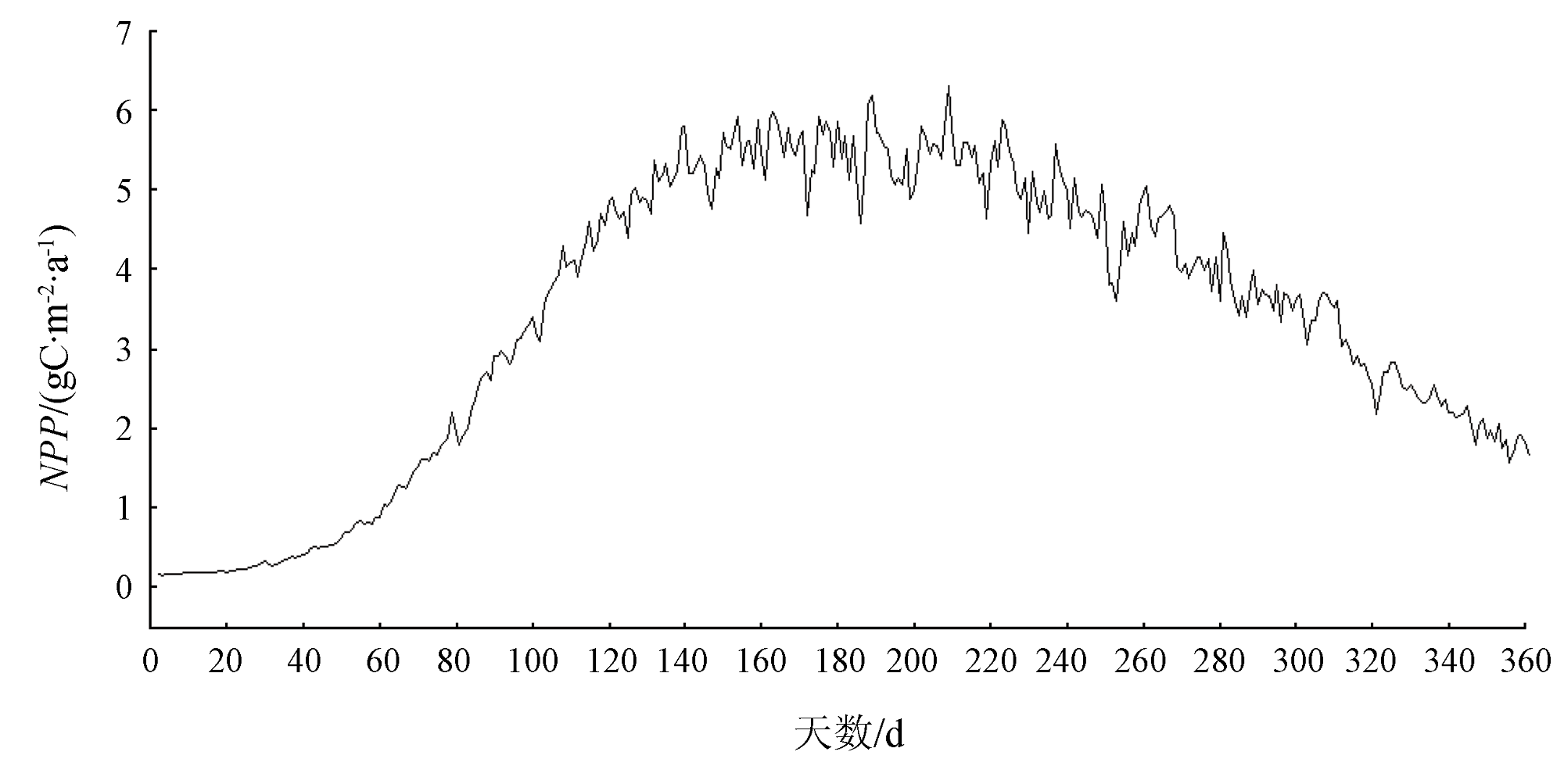
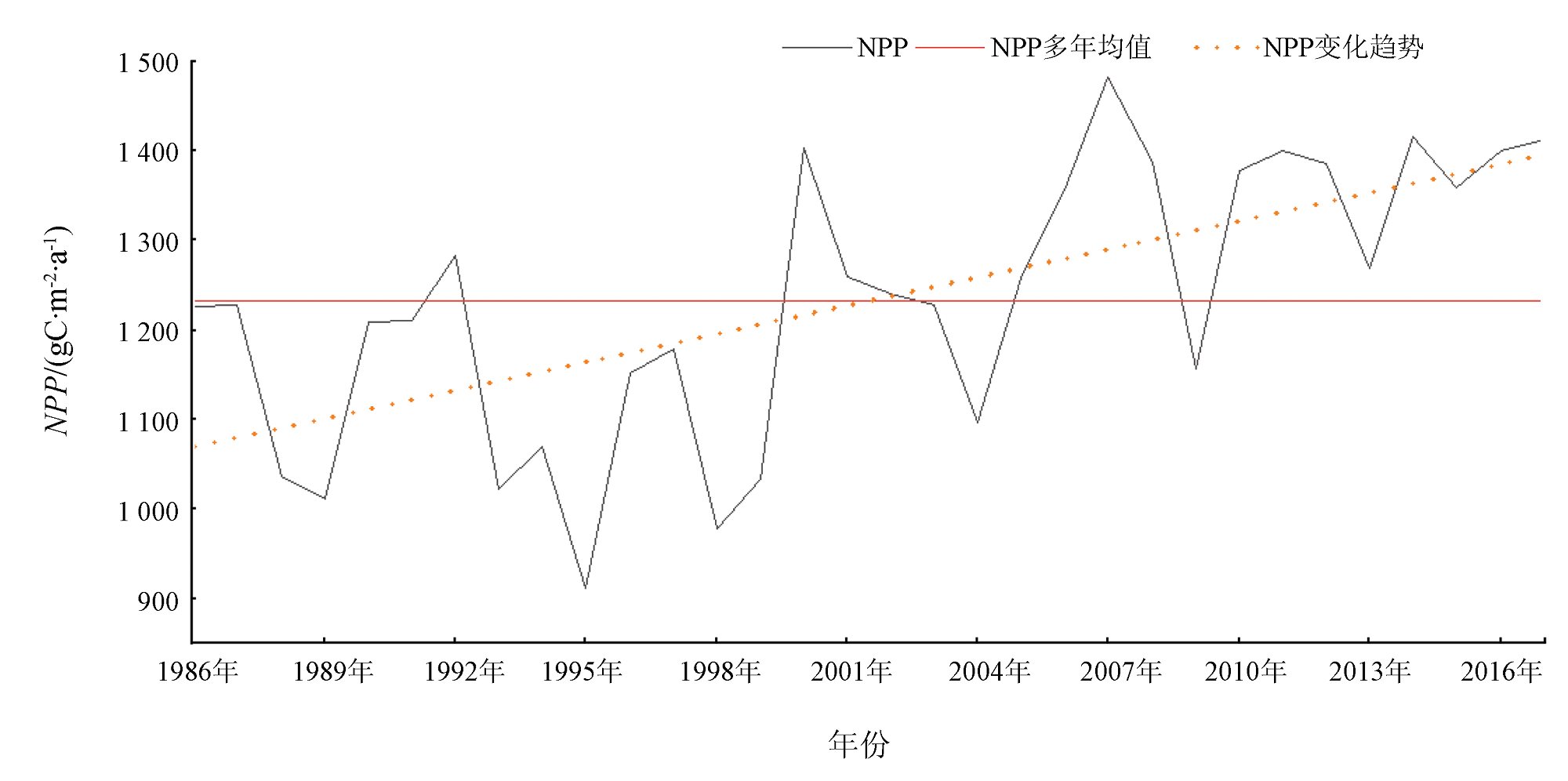
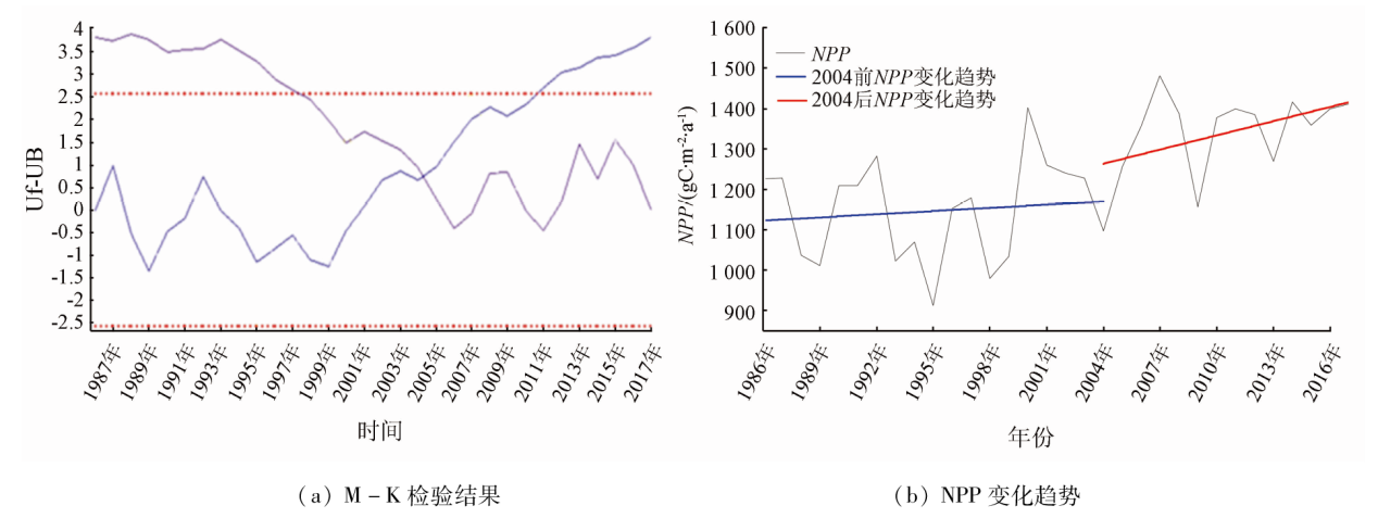
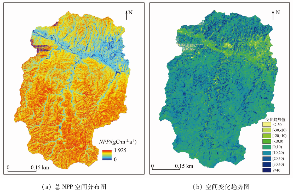
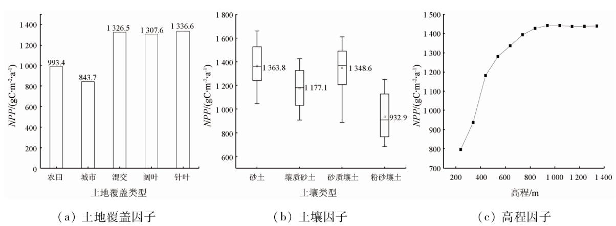
Abstract The simulation-based estimation and spatio-temporal variations of the net primary productivity (NPP) of regional vegetation hold critical significance for analyzing regional vegetation quality and carbon balance. This study investigated the Jianghe River basin in western Hubei Province. First, it pre-processed the input data, including land cover, topography, soil, meteorology, and vegetation indices. Based on this, it estimated the NPP of vegetation in the Jianghe River basin from 1986 to 2017 using the BEPS-TerrainlabV2.0 model, with the model's simulation accuracy evaluated. Moreover, this study explored the spatio-temporal variations of the NPP and its response to environmental changes. The results are as follows: ① The NPP of vegetation in the Jianghe River basin exhibited a unimodal distribution, with higher values in summer and lower values in winter, on an intra-annual scale, and a fluctuating rising trend on an inter-annual scale; ② The spatial distribution of the NPP manifested higher values in the north and lower values in the south; ③ The NPP values of different land cover types followed the sequence below: broad-leaved forests > mixed forests > coniferous forests > farmland > urban areas. The NPP rose with an increase in elevation. The NPP values of different soil textures rank below: sandy soil > sandy loam > loamy sand > silty loam; ④ Radiation and temperature manifested the strongest impact on NPP on a daily basis, and the leaf area index (LAI) exhibited the most significant influence on NPP on an annual basis, both passing the 0.01 significance test.
|
| Keywords
BEPS-TerrainlabV2.0 model
net primary productivity
spatio-temporal variation
environmental impact
|
|
|
|
Issue Date: 21 December 2023
|
|
|
| [1] |
Field C B, Behrenfeld M J, Randerson J T, et al. Primary production of the biosphere:Integrating terrestrial and oceanic components[J]. Science, 1998, 281(5374):237-240.
doi: 10.1126/science.281.5374.237
pmid: 9657713
|
| [2] |
方精云, 柯金虎, 唐志尧, 等. 生物生产力的“4P”概念、估算及其相互关系[J]. 植物生态学报, 2001, 25(4):414-419.
|
| [2] |
Fang J Y, Ke J H, Tang Z Y, et al. Implications and estimations of four terrestrial productivity parameters[J]. Acta Phytoecologica Sinica, 2001, 25(4):414-419.
|
| [3] |
Steffen W, Noble I, M Apps, et al. The terrestrial carbon cycle:Implications for the Kyoto Protocol[J]. Science, 1998, 280(5368):1393-1394.
doi: 10.1126/science.280.5368.1393
url: https://www.science.org/doi/10.1126/science.280.5368.1393
|
| [4] |
Govind A, Chen J M, Margolis H, et al. A spatially explicit hydro-ecological modeling framework (BEPS-TerrainLab V2.0):Model description and test in a boreal ecosystem in Eastern North America[J]. Journal of Hydrology, 2009, 367(3/4):200-216.
doi: 10.1016/j.jhydrol.2009.01.006
url: https://linkinghub.elsevier.com/retrieve/pii/S0022169409000109
|
| [5] |
赵少华, 邱国玉, 杨永辉, 等. 遥感水文耦合模型的研究进展[J]. 生态环境, 2006, 15(6):1391-1396.
|
| [5] |
Zhao S H, Qiu G Y, Yang Y H, et al. Advances in the coupled model of remote sensing and hydrology[J]. Ecology and Environment, 2006, 15(6):1391-1396.
|
| [6] |
Azhdari Z, Rafeie Sardooi E, Bazrafshan O, et al. Impact of climate change on net primary production (NPP) in south Iran[J]. Environ Monit Assess, 2020, 192(6):409.
doi: 10.1007/s10661-020-08389-w
pmid: 32488356
|
| [7] |
Liu J, Chen J M, Cihlar J, et al. Net primary productivity distribution in the BOREAS region from a process model using satellite and surface data[J]. Journal of Geophysical Research:Atmospheres, 1999, 104(D22):27735-27754.
doi: 10.1029/1999JD900768
url: https://agupubs.onlinelibrary.wiley.com/doi/10.1029/1999JD900768
|
| [8] |
Chen J M., Chen X Y, Ju W M, et al. Distributed hydrological model for mapping evapotranspiration using remote sensing inputs[J]. Journal of Hydrology, 2005, 305(1/2/3/4):15-39.
doi: 10.1016/j.jhydrol.2004.08.029
url: https://linkinghub.elsevier.com/retrieve/pii/S0022169404004068
|
| [9] |
Sonnentag O, Chen J M, Roulet N T, et al. Spatially explicit simulation of peatland hydrology and carbon dioxide exchange:Influence of mesoscale topography[J]. Journal of Geophysical Research:Biogeosciences, 2008, 113(G2):477-481.
|
| [10] |
陈镜明, 居为民, 刘荣高, 等. 全球陆地碳汇的遥感和优化计算方法[M]. 北京: 科学出版社, 2015.
|
| [10] |
Chen J M, Ju W M, Liu R G, et al. Remote sensing and optimization calculation method of global terrestrial carbon sink[M]. Beijing: Science Press, 2015.
|
| [11] |
张方敏, 居为民, 陈镜明, 等. 基于BEPS生态模型对亚洲东部地区蒸散量的模拟[J]. 自然资源学报, 2010, 25(9):1596-606.
doi: 10.11849/zrzyxb.2010.09.019
|
| [11] |
Zhang F M, Ju W M, Chen J M, et al. Studyon evapotranspiration in east Asia using the BEPS ecological model[J]. Journal of Natural Resources, 2010, 25(9):1596-606.
|
| [12] |
王修信, 孙涛, 朱启疆, 等. 利用BEPS模型估算城区植被净初级生产力的时空变化[J]. 干旱区资源与环境, 2014, 28(11):1-5.
|
| [12] |
Wang X X, Sun T, Zhu Q J, et al. Spatio-temporal variation of net primary productivity estimated with BEPS model in the urban area[J]. Journal of Arid Land Resources and Environment, 2014, 28(11):1-5.
|
| [13] |
田永生, 郭阳耀, 张培栋, 等. 区域净初级生产力动态及其与气象因子的关系[J]. 草业科学, 2010, 27(2):8-17.
|
| [13] |
Tian Y S, Guo Y Y, Zhang P D, et al. Relationship of regional net primary productivity and related meteorological factors[J]. Pratacultural Science, 2010, 27(2):8-17.
|
| [14] |
刘琦, 孙冰心. M-K和滑动T确定穆棱河流域径流变化突变时间[J]. 黑龙江水利, 2015, 1(7):35-37.
|
| [14] |
Liu Q, Sun B X. Ensure the abrupt runoff change time in Muling river by M-K and sliding T method[J]. Heilongjiang Water Resources, 2015, 1(7):35-37.
|
| [15] |
Wu Z F, Zhang L H, Liu D D, et al. Simulation of Evapotranspiration Based on BEPS-TerrainLab V2.0 from 1990 to 2018 in the Dajiuhu Basin[J]. Chinese Geographical Science, 2020, 30(6):1095-1110.
doi: 10.1007/s11769-020-1160-x
|
| [16] |
刘世荣, 王兵, 郭泉水. 大气CO2浓度增加对生物组织结构与功能的可能影响Ⅱ植物种群、群落、生态系统结构和生产力对大气CO2浓度增加的响应[J]. 地理学报, 1996(s1):141-150.
doi: 10.11821/xb1996S1015
|
| [16] |
Liu S R, Wang B, Guo Q S. Likely Impacts of Rising Atmospheric CO2 Concentration on Plants and Ecosystems Ⅱ.Responses of Plant Population,Community and Forest Ecosystem to Atmospheric CO2 Enrichment[J]. Acta Geographical Sinica, 1996(s1):141-150.
|
| [17] |
朱文泉, 潘耀忠, 张锦水. 中国陆地植被净初级生产力遥感估算[J]. 植物生态学报, 2007, 31(3):413-424.
doi: 10.17521/cjpe.2007.0050
|
| [17] |
Zhu W Q, Pan Y Z, Zhang J S. Estimation of net primary productivity of Chinese terrestrial vegetation based on remote sensing[J]. Journal of Plant Ecology, 2007, 31(3):413-424.
|
| [18] |
刘明亮. 中国土地利用/土地覆盖变化与陆地生态系统植被碳库和生产力研究[D]. 北京: 中国科学院遥感应用技术研究所, 2001.
|
| [18] |
Liu M L. Landuse/landcover change and terrestrial ecosystem phytomass carbon pool and production in China[D]. Beijing: Institute of Remote Sensing Applications, Chinese Academy of Sciences, 2001.
|
| [19] |
薛梅, 陈芸芝, 闫敏, 等. 中国东北地区植被NPP模拟与时空变化分析[J]. 福州大学学报(自然科学版), 2018, 46(6):821-830.
|
| [19] |
Xue M, Chen Y Z, Yan M, et al. Simulation and spatio-temporal variation analysis of net primary productivity in Northeast China[J]. Journal of Fuzhou University( Natural Science Edition), 2018, 46(6):821-830.
|
|
Viewed |
|
|
|
Full text
|
|
|
|
|
Abstract
|
|
|
|
|
Cited |
|
|
|
|
| |
Shared |
|
|
|
|
| |
Discussed |
|
|
|
|
 2023,
Vol. 35
2023,
Vol. 35
 ), ZHANG Lihua(