|
|
 |
|

|
|
|
Impacts of floating solar parks on spatial pattern of land surface temperature |
BO Yingjie1,2( ), ZENG Yelong3, LI Guoqing1(), CAO Xingwen4, YAO Qingxiu2 ), ZENG Yelong3, LI Guoqing1(), CAO Xingwen4, YAO Qingxiu2 |
1. School of Resources and Environmental Engineering, Ludong University, Yantai 264025, China
2. School of Ocean Sciences, China University of Geosciences(Beijing), Beijing 100083, China
3. State Key Laboratory of Remote Sensing Science, Aerospace Information Research Institute, Chinese Academy of Sciences, Beijing 100101, China
4. State Key Laboratory of Desert and Oasis Ecology, Xinjiang Institute of Ecology and Geography, Chinese Academy of Sciences, Urumqi 830011, China |
|
|
|
|
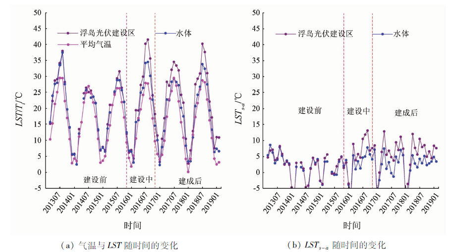
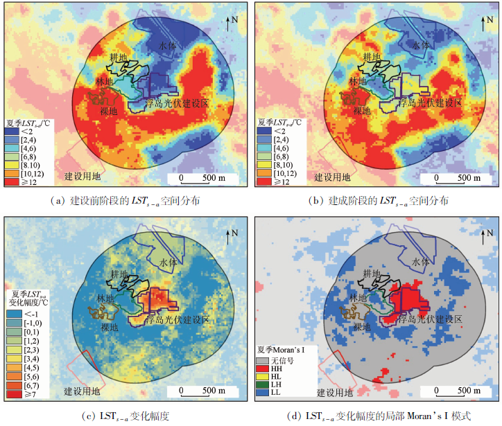
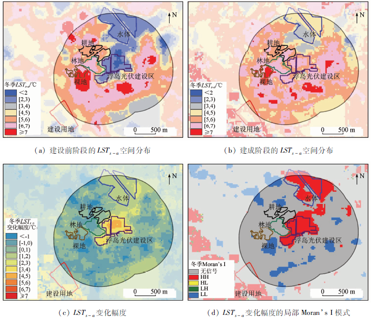
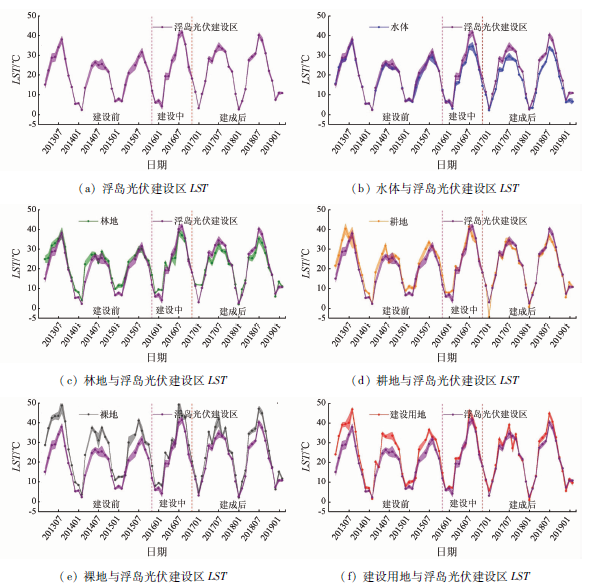
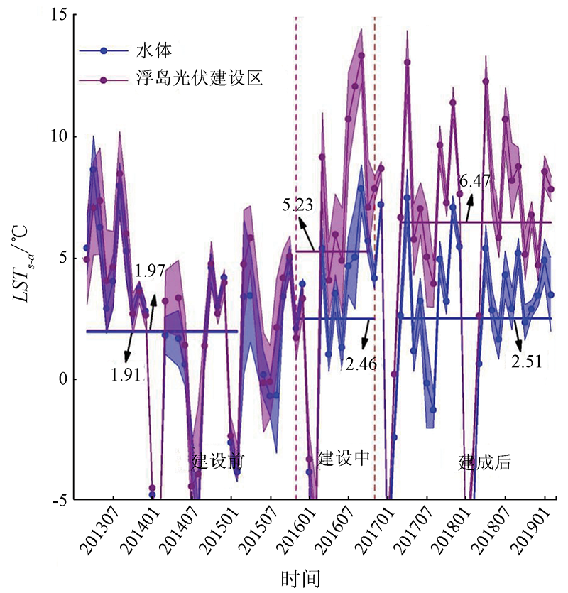
Abstract With the rapid development of China’s photovoltaic industry in recent years, the assessment of the impacts of the large-scale solar parks on the environment is greatly significant for guiding the healthy development of the photovoltaic industry. The changes in the local thermal environment induced by solar parks have attracted the attention of researchers at home and abroad. Floating solar parks (also known as floating-on-water solar parks) serve as a new development mode of photovoltaic power generation in recent years. However, their impacts on the spatial pattern of land surface temperature(LST) are currently unclear. Using the single-channel algorithm, this study extracted the LST dataset of the floating solar park in Huainan City and its adjacent areas from Landsat8 time-series remote sensing data. Then, this study determined the differences between monthly LST and air temperature of the corresponding month (LSTs-a) and analyzed the influencing mode and scopes of floating solar parks on the spatial pattern of LST, as well as their seasonal differences. Finally, this study ascertained the influencing degrees of different construction stages on LST in the construction area. The results are as follows. ① The construction of the floating solar park significantly changed the thermal environment of the construction area, and warming effect occurred during both summer and winter when the temperature changes the most appearantly. Moreover, the warming effect mainly concentrated with 200 m of the construction area, while being very weak in typical surrounding land cover. ② During the construction and the completion phases of the floating solar park, the average monthly LST in the construction area was generally higher than that of the water body and was close to that in the forest. The average annual LST increased by 3.26 ℃ and 4.50 ℃, respectively in the construction and the completion phases. ③ This study can serve as a reference for the related research on assessing the impacts of the floating solar parks on the local environment. The authors recommended conducting an in-depth study from the aspects of the construction of cloudless time-series LST datasets, the separation of the increased/decreased amplitude of the temperature induced by floating solar parks, and the influencing scope and degrees and the genesis analysis of the distribution pattern of LST on the different types of land cover in a floating solar park and its adjacent areas.
|
| Keywords
environmental impact assessment
land surface temperature (LST)
solar photovoltaic power generation
Landsat
|
|
|
|
Corresponding Authors:
LI Guoqing
E-mail: yingjiebo@foxmail.com;ligqing@foxmail.com
|
|
Issue Date: 14 March 2022
|
|
|
| [1] |
Parida B, Iniyan S, Goic R. A review of solar photovoltaic technologies[J]. Renewable and Sustainable Energy Reviews, 2011, 15(3):1625-1636.
doi: 10.1016/j.rser.2010.11.032
url: https://linkinghub.elsevier.com/retrieve/pii/S1364032110004016
|
| [2] |
International Energy Agency. Global gaps in clean energy Rd and D:Update and recommendations[M]. Paris:International Energy Agency, 2010:1-35.
|
| [3] |
Itrpv I. International technology roadmap for photovoltaic results 2017[M]. Frankfurt:VDMA Photovoltaic Equipment, 2020:1-72.
|
| [4] |
Schmela M, Masson G, Mai N N T.Global market outlook for solar power 2016—2020[M]. Belgium:Solar Power Europe, 2016:1-38.
|
| [5] |
International Energy Agency. Renewables 2019[M]. Paris:International Energy Agency, 2019:1-106.
|
| [6] |
Li L, Chi T, Zhang M, et al. Multi-layered capital subsidy policy for the Pv industry in China considering regional differences[J]. Sustainability, 2016, 8:45.
doi: 10.3390/su8010045
url: http://www.mdpi.com/2071-1050/8/1/45
|
| [7] |
朱向东, 贺灿飞, 毛熙彦, 等. 贸易保护背景下中国光伏产业空间格局及其影响因素[J]. 经济地理, 2018, 38(3):98-105.
|
| [7] |
Zhu X D, He C F, Mao X Y, et al. The spatial pattern of China Pv industry under the background of trade protectionism[J]. Economic Geography, 2018, 38(3):98-105.
|
| [8] |
Shuang L, Weigand J, Ganguly S. The potential for climate impacts from widespread deployment of utility-scale solar energy installations:An environmental remote sensing perspective[J]. Journal of Remote Sensing and GIS, 2017, 6(1):1000190.
|
| [9] |
王祯仪, 汪季, 高永, 等. 光伏电站建设对沙区生态环境的影响[J]. 水土保持通报, 2019, 39(1):191-196.
|
| [9] |
Wang Z Y, Wang J, Gao Y, et al. Impacts of photovoltaic power station construction on ecology environment in sandy area[J]. Bulletin of Soil and Water Conservation, 2019, 39(1):191-196.
|
| [10] |
吴菲. 光伏发电站环境影响评价技术规范研究[D]. 南京:南京信息工程大学, 2012.
|
| [10] |
Wu F. Study on technical specifications for environmental impact assessment of photovoltaic power station[D]. Nanjing:Nanjing University of Information Science and Technology, 2012.
|
| [11] |
周茂荣, 王喜君. 光伏电站工程对土壤与植被的影响——以甘肃河西走廊荒漠戈壁区为例[J]. 中国水土保持科学, 2019, 17(2):132-138.
|
| [11] |
Zhou M R, Wang X J. Influence of photovoltaic power station engineering on soil and vegetation:Taking the Gobi desert area in the Hexi corridor of Gansu as an example[J]. Science of Soil and Water Conservation, 2019, 17(2):132-138.
|
| [12] |
郭丹. 光伏发电现状及其环境效应分析[D]. 保定:华北电力大学, 2016.
|
| [12] |
Guo D. Photovoltaic power generation and its environmental effects analysis[D]. Baoding:North China Electric Power University, 2016.
|
| [13] |
李芬, 杨勇, 赵晋斌, 等. 光伏电站建设运行对气候环境的能量影响[J]. 气象科技进展, 2019, 9(2):71-77.
|
| [13] |
Li F, Yang Y, Zhao J B, et al. Review on energy impact of photovoltaic power station construction and operation on climate and environment[J]. Advances in Meteorological Science and Technology, 2019, 9(2):71-77.
|
| [14] |
Bayrakci M, Choi Y, Brownson J R. Temperature dependent power modeling of photovoltaics[J]. Energy Procedia, 2014, 57:745-754.
doi: 10.1016/j.egypro.2014.10.282
url: https://linkinghub.elsevier.com/retrieve/pii/S187661021401649X
|
| [15] |
Pimentel Da Silva G D, Magrini A B, David A C. A multicriteria proposal for large-scale solar photovoltaic impact assessment[J]. Impact Assessment and Project Appraisal, 2019, 38(1):3-15.
doi: 10.1080/14615517.2019.1604938
url: https://www.tandfonline.com/doi/full/10.1080/14615517.2019.1604938
|
| [16] |
Wang S M, Luo X B, Peng Y D. Spatial downscaling of MODIS land surface temperature based on geographically weighted autoregressive model[J]. IEEE Journal of Selected Topics in Applied Earth Observations and Remote Sensing, 2020, 13:2532-2546.
doi: 10.1109/JSTARS.4609443
url: https://ieeexplore.ieee.org/xpl/RecentIssue.jsp?punumber=4609443
|
| [17] |
Liou Y A, Nguyen A K, Li M H. Assessing spatiotemporal eco-environmental vulnerability by Landsat data[J]. Ecological Indicators, 2017, 80:52-65.
doi: 10.1016/j.ecolind.2017.04.055
url: https://linkinghub.elsevier.com/retrieve/pii/S1470160X17302431
|
| [18] |
李彦甫. 基于高分辨率影像的光伏电场信息提取鲁棒性分析及其热环境效应研究[D]. 兰州:兰州大学, 2016.
|
| [18] |
Li Y F. Robustness of photovoltaic electric field information extraction based on high-resolution image and its thermal environment effect[D]. Lanzhou:Lanzhou University, 2016.
|
| [19] |
杨丽薇, 高晓清, 吕芳, 等. 光伏电站对格尔木荒漠地区太阳辐射场的影响研究[J]. 太阳能学报, 2015, 36(9):2160-2166.
|
| [19] |
Yang L W, Gao X Q, Lyu F, et al. Study on the impact of large solar farm on radiation field in desert areas of Golmud[J]. Acta Energiae Solaris Sinica, 2015, 36(9):2160-2166.
|
| [20] |
刘哲, 杨华, 陈星宇, 等. 光伏电场对地表温度的影响分析[J]. 地理空间信息, 2019, 17(10):20-23,10.
|
| [20] |
Liu Z, Yang H, Chen X Y, et al. Impact analysis of solar park on land surface temperature[J]. Geospatial Information, 2019, 17(10):20-23,10.
|
| [21] |
李国庆, Armstrong Alona, 刘哲.光伏电场对地表温度的影响研究[J]. 太阳能学报, 2020, 41(12):117-123.
|
| [21] |
Li G Q, Armstrong A, Liu Z. Effect of solar power plants on land surface temperature[J]. Acta Energiae Solaris Sinica, 2020, 41(12):117-123.
|
| [22] |
Pouran H M. From collapsed coal mines to floating solar farms,why China’s new power stations matter[J]. Energy Policy, 2018, 123:414-420.
doi: 10.1016/j.enpol.2018.09.010
url: https://linkinghub.elsevier.com/retrieve/pii/S0301421518306153
|
| [23] |
Cook M, Schott J R, Mandel J, et al. Development of an operational calibration methodology for the Landsat thermal data archive and initial testing of the atmospheric compensation component of a land surface temperature (LST) product from the archive[J]. Remote Sensing, 2014, 6(11):11244-11266.
doi: 10.3390/rs61111244
url: http://www.mdpi.com/2072-4292/6/11/11244
|
| [24] |
Jiménez-Muñoz J C, Sobrino J A. A generalized single-channel method for retrieving land surface temperature from remote sensing data[J]. Journal of Geophysical Research:Atmospheres, 2003, 108:D22.
|
| [25] |
Jiménez-Muñoz J C, Sobrino J A, Skokovi c ' D, et al. Land surface temperature retrieval methods from Landsat8 thermal infrared sensor data[J]. IEEE Geoscience and Remote Sensing Letters, 2014, 11(10):1840-1843.
doi: 10.1109/LGRS.2014.2312032
url: http://ieeexplore.ieee.org/document/6784508/
|
| [26] |
Eldesoky A H M, Gil J, Pont M B. The suitability of the urban local climate zone classification scheme for surface temperature studies in distinct macroclimate regions[J]. Urban Climate, 2021(37):100823.
|
| [27] |
Wang Y, Ni Z, Hu M, et al. A practical approach of urban green infrastructure planning to mitigate urban overheating:A case study of Guangzhou[J]. Journal of Cleaner Production, 2021(287):124995.
|
| [28] |
Firozjaei M K, Sedighi A, Firozjaei H K, et al. A historical and future impact assessment of mining activities on surface biophysical characteristics change:A remote sensing-based approach[J]. Eco-logical Indicators, 2021(122):107264.
|
| [29] |
Barsi J, Schott J, Palluconi F, et al. Validation of a web-based atmospheric correction tool for single thermal band instruments[M]. SPIE, 2005.
|
| [30] |
Barsi J A, Barker J L, Schott J R. An atmospheric correction parameter calculator for a single thermal band earth-sensing instrument[C]// IEEE International Geoscience and Remote Sensing Symposium, 2003.
|
| [31] |
Sobrino J A, Jiménez-Muñoz J C, Sòria G, et al. Land surface emissivity retrieval from different VNIR and TIR sensors[J]. IEEE transactions on Geoscience and Remote Sensing, 2008, 46(2):316-327.
doi: 10.1109/TGRS.36
url: https://ieeexplore.ieee.org/xpl/RecentIssue.jsp?punumber=36
|
| [32] |
Vancutsem C, Ceccato P, Dinku T, et al. Evaluation of MODIS land surface temperature data to estimate air temperature in different ecosystems over Africa[J]. Remote Sensing of Environment, 2010, 114(2):449-465.
doi: 10.1016/j.rse.2009.10.002
url: https://linkinghub.elsevier.com/retrieve/pii/S0034425709003113
|
| [33] |
韩秀珍, 李三妹, 窦芳丽. 气象卫星遥感地表温度推算近地表气温方法研究[J]. 气象学报, 2012, 70(5):1107-1118.
|
| [33] |
Han X Z, Li S M, Dou F L. Study of obtaining high resolution near-surface atmosphere temperature by using the land surface temperature from meteorological satellite data[J]. Acta Meteorologica Sinica, 2012, 70(5):1107-1118.
|
| [34] |
姚永慧, 张百平, 韩芳. 基于MODIS地表温度的横断山区气温估算及其时空规律分析[J]. 地理学报, 2011, 66(7):917-927.
|
| [34] |
Yao Y H, Zhang B P, Han F. MODIS-based air temperature estimation in the Hengduan Mountains and its spatio-temporal analysis[J]. Acta Geographica Sinica, 2011, 66(7):917-927.
|
| [35] |
Anselin L. Local indicators of spatial association—Lisa[J]. Geographical Analysis, 1995, 27(2):93-115.
doi: 10.1111/gean.1995.27.issue-2
url: http://doi.wiley.com/10.1111/gean.1995.27.issue-2
|
| [36] |
Kan A K, Li G Q, Yang X, et al. Ecological vulnerability analysis of Tibetan towns with tourism-based economy:A case study of the Bayi District[J]. Journal of Mountain Science, 2018, 15(5):1101-1114.
doi: 10.1007/s11629-017-4789-x
url: http://link.springer.com/10.1007/s11629-017-4789-x
|
| [37] |
孟丹, 王明玉, 李小娟, 等. 京沪穗三地近十年夜间热力景观格局演变对比研究[J]. 生态学报, 2013, 33(5):1545-1558.
|
| [37] |
Meng D, Wang M Y, Li X J, et al. The dynamic change of the thermal environment landscape patterns in Beijing,Shanghai and Guangzhou in the recent past decade[J]. Acta Ecologica Sinica, 2013, 33(5):1545-1558.
doi: 10.5846/stxb
url: http://www.ecologica.cn/
|
| [38] |
Bartesaghi-Koc C, Osmond P, Peters A. Spatio-temporal patterns in green infrastructure as driver of land surface temperature variability:The case of Sydney[J]. International Journal of Applied Earth Observation and Geoinformation, 2019, 83:101903.
doi: 10.1016/j.jag.2019.101903
url: https://linkinghub.elsevier.com/retrieve/pii/S0303243419302661
|
| [39] |
Fan C, Wang Z. Spatiotemporal characterization of land cover impacts on urban warming:A spatial autocorrelation approach[J]. Remote Sensing, 2020, 12(10):1631.
doi: 10.3390/rs12101631
url: https://www.mdpi.com/2072-4292/12/10/1631
|
| [40] |
吴迪, 陈健, 石满, 等. 基于Savitzky-Golay滤波算法的FY-2F地表温度产品时间序列重建[J]. 自然资源遥感, 2019, 31(2):59-65.doi: 10.6046/gtzyyg.2019.02.09.
doi: 10.6046/gtzyyg.2019.02.09
|
| [40] |
Wu D, Chen J, Shi M, et al. Reconstruction of land surface temperature time-series datasets of FY-2F based on Savitzky-Golay filter[J]. Remote Sensing for Land and Resources, 2019, 31(2):59-65.doi: 10.6046/gtzyyg.2019.02.09.
doi: 10.6046/gtzyyg.2019.02.09
|
| [41] |
徐永明, 覃志豪, 沈艳. 长江三角洲地区地表温度年内变化规律与气候因子的关系分析[J]. 自然资源遥感, 2010(1):60-64.doi: 10.6046/gtzyyg.2010.01.10.
doi: 10.6046/gtzyyg.2010.01.10
|
| [41] |
Xu Y M, Qin Z H, Shen Y. The relationship between inter-annual variations of land surfacetemperature and climate factors in the Yangtze River Delta[J]. Remote Sensing for Land and Resources, 2010, 22(1):60-64.doi: 10.6046/gtzyyg.2010.01.10.
doi: 10.6046/gtzyyg.2010.01.10
|
| [42] |
Chang R, Shen Y B, Luo Y, et al. Observed surface radiation and temperature impacts from the large-scale deployment of photovoltaics in the Barren area of Gonghe,China[J]. Renewable Energy, 2018, 118:131-137.
doi: 10.1016/j.renene.2017.11.007
url: https://linkinghub.elsevier.com/retrieve/pii/S0960148117311084
|
| [43] |
殷代英, 马鹿, 屈建军, 等. 大型光伏电站对共和盆地荒漠区微气候的影响[J]. 水土保持通报, 2017, 37(3):15-21.
|
| [43] |
Yin D Y, Ma L, Qu J J, et al. Effect of large photovoltaic power station on microclimate of desert region in Gonghe Basin[J]. Bulletin of Soil and Water Conservation, 2017, 37(3):15-21.
|
|
Viewed |
|
|
|
Full text
|
|
|
|
|
Abstract
|
|
|
|
|
Cited |
|
|
|
|
| |
Shared |
|
|
|
|
| |
Discussed |
|
|
|
|
 2022,
Vol. 34
2022,
Vol. 34