|
|
|
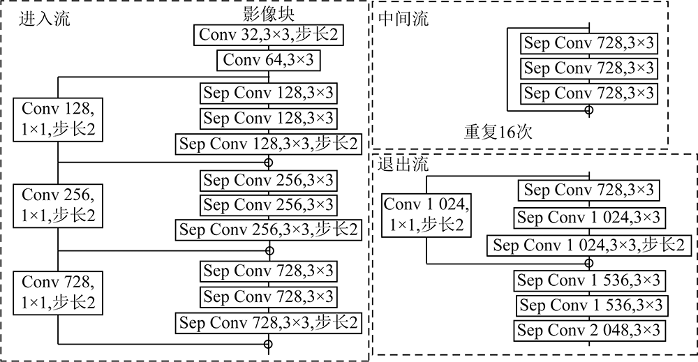
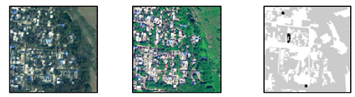
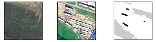
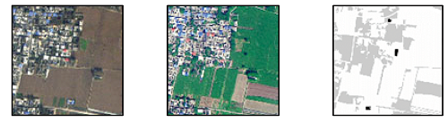
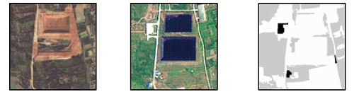
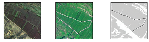
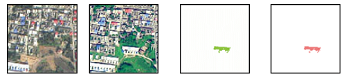
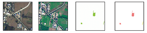
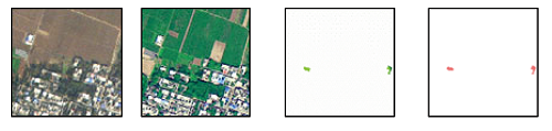
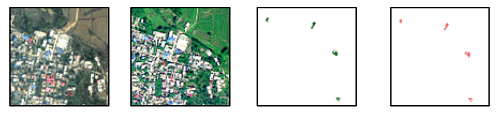
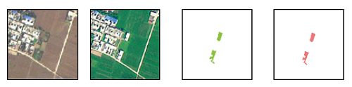
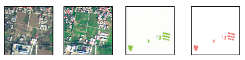
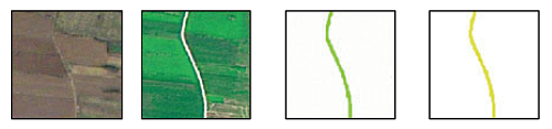
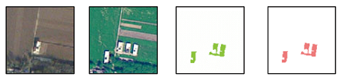
Abstract The accurate acquisition of land cover/use changes and their types is critical to territorial space planning, ecological environment monitoring, and disaster assessment. However, most current studies on the change detection focus on binary change detection. This study proposed a multi-class change detection method using a multi-task Siamese network of remote sensing images. First, an object-oriented unsupervised change detection method was employed to select areas that were most/least prone to change in the new and old temporal images. These areas were used as samples for the multi-task Siamese network. Subsequently, the multi-task Siamese network model was used to learn and predict the new and old temporal land-use maps and binary change maps. Finally, the final multi-class change detection results were derived from these maps. The multi-task Siamese network was tested based on the images from the Third National Land Survey and corresponding land-use maps. The results demonstrate that the method proposed in this study is applicable to the change detection cases where changed and unchanged samples lack but there are available historical thematic maps.
|
| Keywords
multi-task learning
Siamese network
multi-class change detection
the third national land resource survey
|
|
|
|
Issue Date: 13 March 2024
|
|
|
| [1] |
史文中, 张鹏林. 光学遥感影像变化检测研究的回顾与展望[J]. 武汉大学学报(信息科学版), 2018, 43(12):1832-1837.
|
| [1] |
Shi W Z, Zhang P L. State-of-the-art remotely sensed images-based change detection methods[J]. Geomatics and Information Science of Wuhan University, 2018, 43(12):1832-1837.
|
| [2] |
李德仁. 利用遥感影像进行变化检测[J]. 武汉大学学报(信息科学版), 2003, 28(s1):7-12.
|
| [2] |
Li D R. Change detection from remote sensing images[J]. Geomatics and Information Science of Wuhan University, 2003, 28(s1):7-12.
|
| [3] |
任秋如, 杨文忠, 汪传建, 等. 遥感影像变化检测综述[J]. 计算机应用, 2021, 41(8):2294-2305.
doi: 10.11772/j.issn.1001-9081.2020101632
|
| [3] |
Ren Q R, Yang W Z, Wang C J, et al. Review of remote sensing image change detection[J]. Journal of Computer Applications, 2021, 41(8):2294-2305.
doi: 10.11772/j.issn.1001-9081.2020101632
|
| [4] |
杨存建, 欧晓昆, 党承林, 等. 森林植被动态变化信息的遥感检测[J]. 地球信息科学, 2000, 2(4):71-74.
|
| [4] |
Yang C J, Ou X K, Dang C L, et al. Detecting the change information of forest vegetation in Lushui County of Yunnan Province[J]. Geo-Information Science, 2000, 2(4):71-74.
|
| [5] |
Li P J, Xu H Q. Land-cover change detection using one-class support vector machine[J]. Photogrammetric Engineering and Remote Sensing, 2010, 76(3):255-263.
doi: 10.14358/PERS.76.3.255
url: http://openurl.ingenta.com/content/xref?genre=article&issn=0099-1112&volume=76&issue=3&spage=255
|
| [6] |
Cao G, Li Y P, Liu Y Z, et al. Automatic change detection in high-resolution remote-sensing images by means of level set evolution and support vector machine classification[J]. International Journal of Remote Sensing, 2014, 35(16):6255-6270.
doi: 10.1080/01431161.2014.951740
url: https://www.tandfonline.com/doi/full/10.1080/01431161.2014.951740
|
| [7] |
Zhang Z J, Li A N, Lei G B, et al. Change detection of remote sensing images based on multiscale segmentation and decision tree algorithm over mountainous area:A case study in Panxi region,Sichuan Province[J]. Acta Ecologica Sinica, 2014, 34(24):7222-7232.
|
| [8] |
黄晓君, 颉耀文, 卫娇娇, 等. 基于变化检测-CART决策树模式自动识别沙漠化信息[J]. 灾害学, 2017, 32(1):36-42.
|
| [8] |
Huang X J, Xie Y W, Wei J J, et al. Automatic recognition of desertification information based on the pattern of change detection-CART decision tree[J]. Journal of Catastrophology, 2017, 32(1):36-42.
|
| [9] |
Seo D K, Kim Y H, Eo Y D, et al. Generation of radiometric,phenological normalized image based on random forest regression for change detection[J]. Remote Sensing, 2017, 9(11):1163.
doi: 10.3390/rs9111163
url: http://www.mdpi.com/2072-4292/9/11/1163
|
| [10] |
冯文卿, 眭海刚, 涂继辉, 等. 高分辨率遥感影像的随机森林变化检测方法[J]. 测绘学报, 2017, 46(11):1880-1890.
doi: 10.11947/j.AGCS.2017.20170074
|
| [10] |
Feng W Q, Sui H G, Tu J H, et al. Change detection method for high resolution remote sensing images using random forest[J]. Acta Geodaetica et Cartographica Sinica, 2017, 46(11):1880-1890.
doi: 10.11947/j.AGCS.2017.20170074
|
| [11] |
Wang Q M, Shi W Z, Atkinson P M, et al. Land cover change detection at subpixel resolution with a hopfield neural network[J]. IEEE Journal of Selected Topics in Applied Earth Observations and Remote Sensing, 2015, 8(3):1339-1352.
doi: 10.1109/JSTARS.4609443
url: https://ieeexplore.ieee.org/xpl/RecentIssue.jsp?punumber=4609443
|
| [12] |
Cao G, Liu Y Z, Shang Y F. Automatic change detection in remote sensing images using level set method with neighborhood constraints[J]. Journal of Applied Remote Sensing, 2014, 8(1):083678.
doi: 10.1117/1.JRS.8.083678
url: http://remotesensing.spiedigitallibrary.org/article.aspx?doi=10.1117/1.JRS.8.083678
|
| [13] |
严明, 曹国, 夏梦. 基于水平集演化和支持向量机分类的高分辨率遥感图像自动变化检测[J]. 哈尔滨理工大学学报, 2019, 24(1):78-84.
|
| [13] |
Yan M, Cao G, Xia M. Automatic change detection of high resolution remote sensing images based on level set evolution and support vector machine classification[J]. Journal of Harbin University of Science and Technology, 2019, 24(1):78-84.
|
| [14] |
Bruzzone L, Prieto D F. Automatic analysis of the difference image for unsupervised change detection[J]. IEEE Transactions on Geoscience and Remote Sensing, 2000, 38(3):1171-1182.
doi: 10.1109/36.843009
url: http://ieeexplore.ieee.org/document/843009/
|
| [15] |
Zhou L C, Cao G, Li Y P, et al. Change detection based on conditional random field with region connection constraints in high-resolution remote sensing images[J]. IEEE Journal of Selected Topics in Applied Earth Observations and Remote Sensing, 2016, 9(8):3478-3488.
doi: 10.1109/JSTARS.4609443
url: https://ieeexplore.ieee.org/xpl/RecentIssue.jsp?punumber=4609443
|
| [16] |
魏立飞, 牟紫微, 王晓燕, 等. 基于CRF模型的高分辨率遥感影像变化检测[J]. 测绘通报, 2017, 9:28-31.
|
| [16] |
Wei L F, Mou Z W, Wang X Y, et al. Change detection of high resolution remote sensing image based on CRF model[J]. Bulletin of Surveying and Mapping, 2017, 9:28-31.
|
| [17] |
Weismiller R A, Kristof S J, Scholz D K, et al. Change detection in coastal zone environments[J]. Photogrammetric Engineering and Remote Sensing, 1977, 42(12):1533-1539.
|
| [18] |
Malila W A. Change vector analysis:An approach for detecting forest changes with Landsat[J]. Proceedings of the Society of Photo-Optical Instrumentation Engineers, 1980:326-336.
|
| [19] |
Jensen J R, Toll D L. Detecting residential land use development at the urban fringe[J]. Photogrammetric Engineering and Remote Sensing, 1982, 48:629-643.
|
| [20] |
Byrne G F, Crapper P F, Mayo K K. Monitoring land cover change by principal component analysis of multitemporal Landsat data[J]. Remote Sensing of Environment, 1980, 10(3):175-184.
doi: 10.1016/0034-4257(80)90021-8
url: https://linkinghub.elsevier.com/retrieve/pii/0034425780900218
|
| [21] |
Ingebritsen S E, Lyon R J P. Principal components analysis of multitemporal image pairs[J]. International Journal of Remote Sensing, 1985, 6(5):687-696.
doi: 10.1080/01431168508948491
url: https://www.tandfonline.com/doi/full/10.1080/01431168508948491
|
| [22] |
吴海平, 温礼, 邓凯, 等. 基于深度学习的高分辨率遥感影像自动变化检测[J]. 测绘与空间地理信息, 2021, 44(7):102-106.
|
| [22] |
Wu H P, Wen L, Deng K, et al. Deep learning based change detection for high-resolution remote sensing images[J]. Geomatics & Spatial Information Technology, 2021, 44(7):102-106.
|
| [23] |
Su L Z, Gong M G, Zhang P Z, et al. Deep learning and mapping based ternary change detection for information unbalanced images[J]. Pattern Recognition, 2017, 66:213-228.
doi: 10.1016/j.patcog.2017.01.002
url: https://linkinghub.elsevier.com/retrieve/pii/S003132031730002X
|
| [24] |
Gong M G, Zhan T, Zhang P Z, et al. Superpixel-based difference representation learning for change detection in multispectral remote sensing images[J]. IEEE Transactions on Geoscience and Remote Sensing, 2017, 55(5):2658-2673.
doi: 10.1109/TGRS.2017.2650198
url: http://ieeexplore.ieee.org/document/7839934/
|
| [25] |
Zhang H, Gong M G, Zhang P Z, et al. Feature-level change detection using deep representation and feature change analysis for multispectral imagery[J]. IEEE Geoscience and Remote Sensing Letters, 2016, 13(11):1666-1670.
doi: 10.1109/LGRS.2016.2601930
url: http://ieeexplore.ieee.org/document/7559716/
|
| [26] |
Mou L C, Bruzzone L, Zhu X X. Learning spectral-spatial-temporal features via a recurrent convolutional neural network for change detection in multispectral imagery[J]. IEEE Transactions on Geoscience and Remote Sensing, 2019, 57(2):924-935.
doi: 10.1109/TGRS.2018.2863224
url: https://ieeexplore.ieee.org/document/8541102/
|
| [27] |
Li S C, Han P C, Bu S H, et al. Change detection in images using shape-aware Siamese convolutional network[J]. Engineering Applications of Artificial Intelligence, 2020, 94:103819.
doi: 10.1016/j.engappai.2020.103819
url: https://linkinghub.elsevier.com/retrieve/pii/S0952197620301950
|
| [28] |
Chen H R X, Wu C, Du B, et al. Change detection in multisource VHR images via deep Siamese convolutional multiple-layers recurrent neural network[J]. IEEE Transactions on Geoscience and Remote Sensing, 2020, 58(4):2848-2864.
doi: 10.1109/TGRS.36
url: https://ieeexplore.ieee.org/xpl/RecentIssue.jsp?punumber=36
|
| [29] |
Gong M G, Niu X D, Zhang P Z, et al. Generative adversarial networks for change detection in multispectral imagery[J]. IEEE Geoscience and Remote Sensing Letters, 2017, 14(12):2310-2314.
doi: 10.1109/LGRS.2017.2762694
url: http://ieeexplore.ieee.org/document/8094357/
|
| [30] |
Li B L, Zhou Q M. Accuracy assessment on multi-temporal land-cover change detection using a trajectory error matrix[J]. International Journal of Remote Sensing, 2009, 30(5):1283-1296.
doi: 10.1080/01431160802474022
url: https://www.tandfonline.com/doi/full/10.1080/01431160802474022
|
|
Viewed |
|
|
|
Full text
|
|
|
|
|
Abstract
|
|
|
|
|
Cited |
|
|
|
|
| |
Shared |
|
|
|
|
| |
Discussed |
|
|
|
|
 2024,
Vol. 36
2024,
Vol. 36
 ), LIU Bo2(