|
|
 |
|

|
|
|
Monitoring a landslide with a multi-deformation magnitude based on the phase and amplitude information of SAR images: A case study of the Baige landslide in Jinsha River |
YANG Fan1( ), MA Zhigang2, WEN Yan2, Dong Jie3(), JIANG Qinghui4 ), MA Zhigang2, WEN Yan2, Dong Jie3(), JIANG Qinghui4 |
1. State Key Laboratory of Surveying, Mapping and Remote Sensing Information Engineering, Wuhan University, Wuhan 430079, China
2. Sichuan Institute of Territorial Space Ecological Restoration and Geological Disaster Prevention and Control, Chengdu 610084, China
3. School of Remote Sensing Information Engineering, Wuhan University, Wuhan 430079, China
4. School of Civil Engineering, Wuhan University, Wuhan 430079, China |
|
|
|
|
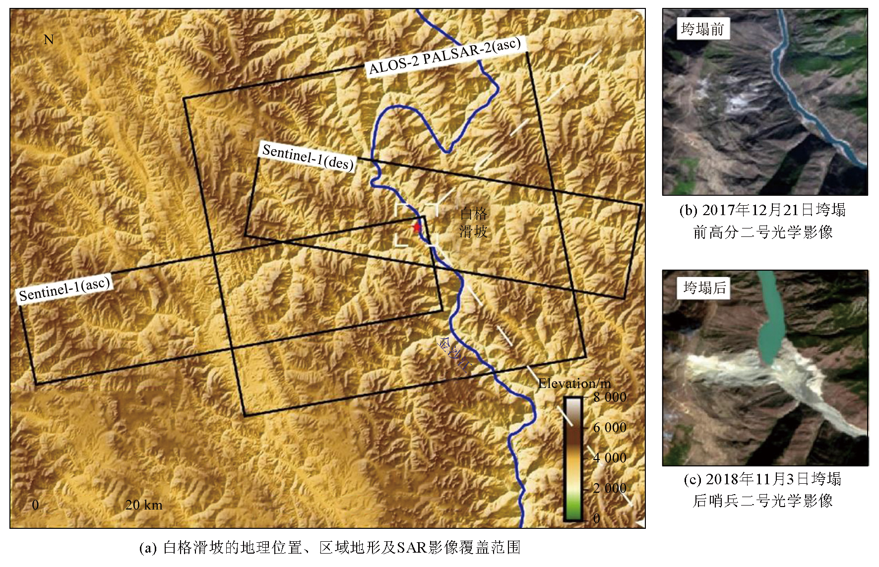
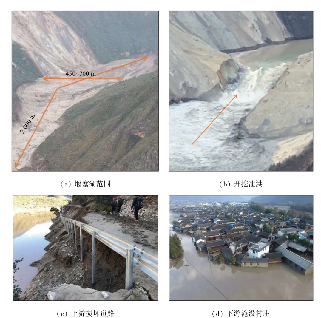
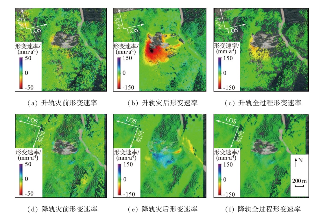
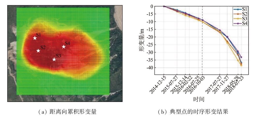
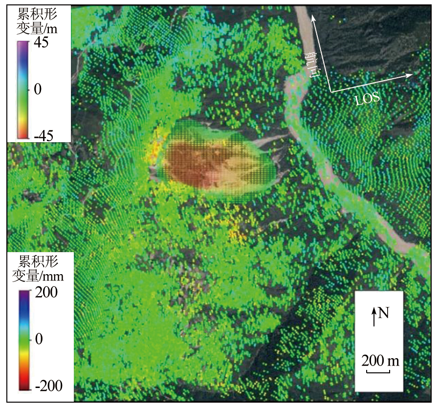
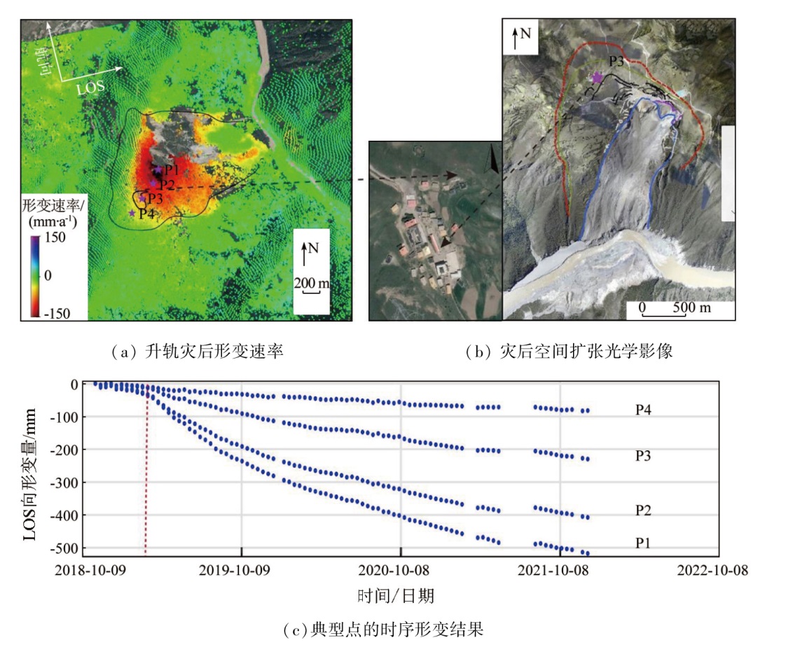
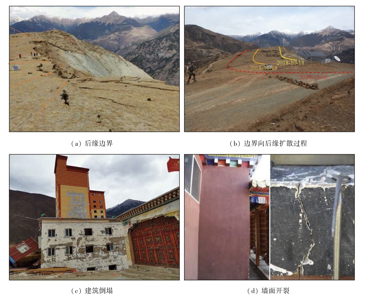
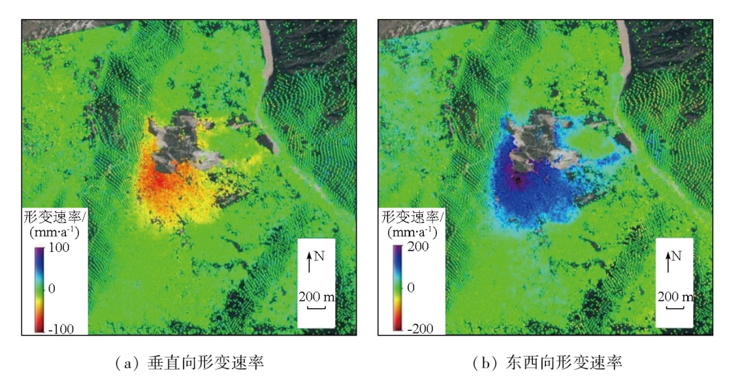
Abstract In recent years, radar remote sensing has been extensively applied to extract high-precision deformation information of landslide surfaces. The techniques used include phase-based interferometry and amplitude-based pixel offset tracking (POT). However, large complex landslides exhibit significantly different deformation magnitudes over the spatio-temporal evolution, complicating the comprehensive monitoring of landslide deformation via single radar remote sensing. Hence, by analyzing the deformation detection capability of radar remote sensing, this study proposed monitoring the whole process of a landslide combined with the phase and amplitude information of synthetic aperture radar (SAR) images. This study investigated the Baige landslide occurring in Jinsha River in 2018 based on Sentinel-1 data from 2014 to 2021 and ALOS-2 data from 2014 to 2018. Combined with time-series interferometric SAR (InSAR) analysis and POT, this study acquired the pre- and post-disaster time-series deformations of the landslide. The results are as follows. Pre-disaster, the trailing edge of the Baige landslide exhibited an average annual rate of 20 mm/a, with deformation of the main landslide area up to about 45 m from December 2014 to July 2018. Post-disaster, the landslide gradually expanded to the trailing edge, with an average annual deformation rate reaching 200 mm/a, threatening the safety of some civilian houses. Therefore, the combined method in this study can achieve the multi-deformation magnitude extraction of large complex landslides from spatio-temporal dimensions.
|
| Keywords
interferometry
pixel offset tracking
multi-deformation magnitude
large landslide
|
|
|
|
Issue Date: 14 June 2024
|
|
|
| [1] |
黄润秋. 20世纪以来中国的大型滑坡及其发生机制[J]. 岩石力学与工程学报, 2007, 26(3):433-454.
|
| [1] |
Huang R Q. Large-scale landslides and their sliding mechanisms in China since the 20th century[J]. Chinese Journal of Rock Mechanics and Engineering, 2007, 26(3):433-454.
|
| [2] |
李振洪, 宋闯, 余琛, 等. 卫星雷达遥感在滑坡灾害探测和监测中的应用:挑战与对策[J]. 武汉大学学报(信息科学版), 2019, 44(7):967-979.
|
| [2] |
Li Z H, Song C, Yu C, et al. Application of satellite radar remote sensing to landslide detection and monitoring:Challenges and solutions[J]. Geomatics and Information Science of Wuhan University, 2019, 44(7):967-979.
|
| [3] |
许强, 汤明高, 黄润秋. 大型滑坡监测预警与应急处置[M]. 北京: 科学出版社, 2015.
|
| [3] |
Xu Q, Tang M G, Huang R Q. Monitoring, early warning and emergency disposal of large landslide[M]. Beijing: Science Press, 2015.
|
| [4] |
李德仁, 周月琴, 马洪超. 卫星雷达干涉测量原理与应用[J]. 测绘科学, 2000, 25(1):9-12.
|
| [4] |
Li D R, Zhou Y Q, Ma H C. Principle and application of interferometry SAR[J]. Science of Surveying and Mapping, 2000, 25(1):9-12.
|
| [5] |
郭华东, 邵芸, 王长林. 雷达对地观测理论与应用[M]. 北京: 科学出版社, 2000.
|
| [5] |
Guo H D, Shao Y, Wang C L. Radar for earth observation[M]. Beijing: Science Press, 2000.
|
| [6] |
廖明生, 王腾. 时间序列InSAR技术与应用[M]. 北京: 科学出版社, 2014.
|
| [6] |
Liao M S, Wang T. Time series InSAR technology and its application[M]. Beijing: Science Press, 2014.
|
| [7] |
廖明生, 林珲. 雷达干涉测量:原理与信号处理基础[M]. 北京: 测绘出版社, 2003.
|
| [7] |
Liao M S, Lin H. Synthetic aperture Radar interferometry[M]. Beijing: Sino Maps Press, 2003.
|
| [8] |
廖明生, 张路, 史绪国, 等. 滑坡变形雷达遥感监测方法与实践[M]. 北京: 科学出版社, 2017.
|
| [8] |
Liao M S, Zhang L, Shi X G, et al. Radar remote sensing monitoring method and practice of landslide deformation[M]. Beijing: Science Press, 2017.
|
| [9] |
Fruneau B, Achache J, Delacourt C. Observation and modelling of the Saint-Étienne-de-Tinée landslide using SAR interferometry[J]. Tectonophysics, 1996, 265(3/4):181-190.
|
| [10] |
Liao M, Tang J, Wang T, et al. Landslide monitoring with high-resolution SAR data in the Three Gorges region[J]. Science China Earth Sciences, 2012, 55(4):590-601.
|
| [11] |
朱建军, 李志伟, 胡俊. InSAR变形监测方法与研究进展[J]. 测绘学报, 2017, 46(10):1717-1733.
doi: 10.11947/j.AGCS.2017.20170350
|
| [11] |
Zhu J J, Li Z W, Hu J. Research progress and methods of InSAR for deformation monitoring[J]. Acta Geodaetica et Cartographica Sinica, 2017, 46(10):1717-1733.
doi: 10.11947/j.AGCS.2017.20170350
|
| [12] |
Michel R, Avouac J P, Taboury J. Measuring ground displacements from SAR amplitude images:Application to the Landers Earthquake[J]. Geophysical Research Letters, 1999, 26(7):875-878.
|
| [13] |
Manconi A, Casu F, Ardizzone F, et al. Brief communication:Rapid mapping of landslide events:The 3 December 2013 Montescaglioso landslide,Italy[J]. Natural Hazards and Earth System Sciences, 2014, 14(7):1835-1841.
|
| [14] |
Cai J, Wang C, Mao X, et al. An adaptive offset tracking method with SAR images for landslide displacement monitoring[J]. Remote Sensing, 2017, 9(8):830.
|
| [15] |
Saito M. Forecasting time of slope failure by tertiary creep[C]// Proceedings of the Seventh International Conference on Soil Mechanics and Foundation Engineering.Mexico, 1969:677-683.
|
| [16] |
许强, 郑光, 李为乐, 等. 2018年10月和11月金沙江白格两次滑坡-堰塞堵江事件分析研究[J]. 工程地质学报, 2018, 26(6):1534-1551.
|
| [16] |
Xu Q, Zheng G, Li W L, et al. Study on successive landslide damming events of Jinsha River in Baige Village on Octorber 11 and November 3,2018[J]. Journal of Engineering Geology, 2018, 26(6):1534-1551.
|
| [17] |
Fan X, Xu Q, Alonso-Rodriguez A, et al. Successive landsliding and damming of the Jinsha River in eastern Tibet,China:Prime investigation,early warning,and emergency response[J]. Landslides, 2019, 16(5):1003-1020.
|
| [18] |
Berardino P, Fornaro G, Lanari R, et al. A new algorithm for surface deformation monitoring based on small baseline differential SAR interferograms[J]. IEEE Transactions on Geoscience and Remote Sensing, 2002, 40(11):2375-2383.
|
| [19] |
Massonnet D, Feigl K L. Radar interferometry and its application to changes in the Earth’s surface[J]. Reviews of Geophysics, 1998, 36(4):441-500.
|
| [20] |
Baran I, Stewart M, Claessens S. A new functional model for determining minimum and maximum detectable deformation gradient resolved by satellite radar interferometry[J]. IEEE Transactions on Geoscience and Remote Sensing, 2005, 43(4):675-682.
|
| [21] |
Jiang M, Li Z W, Ding X L, et al. Modeling minimum and maximum detectable deformation gradients of interferometric SAR measurements[J]. International Journal of Applied Earth Observation and Geoinformation, 2011, 13(5):766-777.
|
| [22] |
Bamler R, Eineder M. Accuracy of differential shift estimation by correlation and split-bandwidth interferometry for wideband and delta-k SAR systems[J]. IEEE Geoscience and Remote Sensing Letters, 2005, 2(2):151-155.
|
| [23] |
Hanssen R F. Radar Interferometry[M]. Netherlands:Springer, 2001:172-176.
|
| [24] |
Hooper A, Zebker H, Segall P, et al. A new method for measuring deformation on volcanoes and other natural terrains using InSAR persistent scatterers[J]. Geophysical Research Letters, 2004, 31(23):L23611.
|
|
Viewed |
|
|
|
Full text
|
|
|
|
|
Abstract
|
|
|
|
|
Cited |
|
|
|
|
| |
Shared |
|
|
|
|
| |
Discussed |
|
|
|
|
 2024,
Vol. 36
2024,
Vol. 36