|
|
 |
|

|
|
|
Knowledge representation for Earth observation resources |
LIN Ming1( ), JIN Meng1, LIU Yufu1, BAI Yuqi1,2() ), JIN Meng1, LIU Yufu1, BAI Yuqi1,2() |
1. Department of Earth System Science, Ministry of Education Ecological Field Station for East Asian Migratory Birds and Their Habitatses, Institute for Global Change Studies, Tsinghua University, Beijing 100084, China
2. Tsinghua Urban Institute, Tsinghua University, Beijing 100084, China |
|
|
|
|
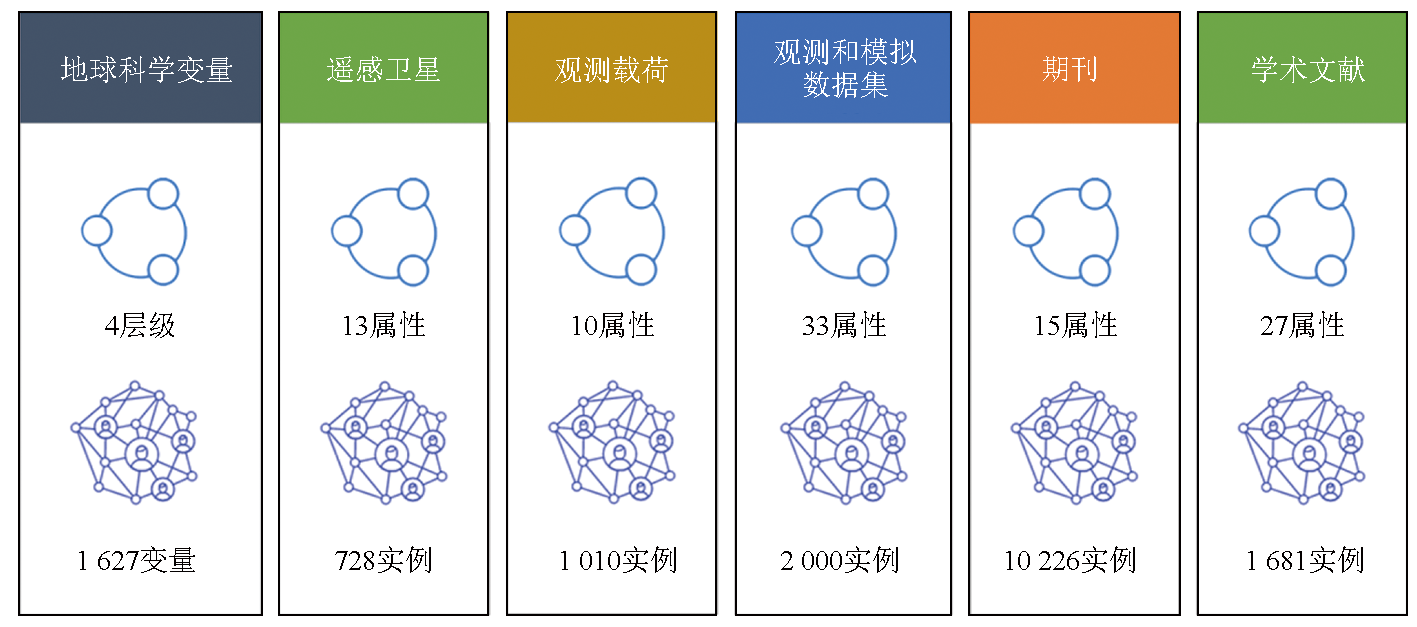
Abstract At its 16th Plenary Session and Ministerial Summit, the Group on Earth Observations (GEO) proposed a new goal to build a “digital library for Earth observation applications”, highlighting the transition from “open data” to “open science”. It aims to achieve the management and sharing of knowledge resources, including data, algorithms, literature, and cases, thereby facilitating the comprehensive application and knowledge service provision of Earth observations in fields such as global change. Under this research background, this study systematically examined Earth observation data resources, including the conceptual system of Earth science variables, Earth observation satellites and payloads, observational and simulated data products, and open knowledge bases of academic literature. Based on the theories and techniques related to the Semantic Web and Knowledge Graph, this study established the Earth observation knowledge ontology with corresponding instances, involving Earth science variables, remote sensing satellites, observation payloads, observational and simulated datasets, journals, and academic literature. The knowledge representation results of this study will contribute to the representation, management, and integration of data and knowledge in the field of Earth observation applications. Moreover, they facilitate the discovery of potential associations between data and knowledge, enhancing the efficiency of scientific research and advancing scientific discovery.
|
| Keywords
Earth observation
knowledge hub
knowledge representation
ontology
knowledge graph
|
|
|
|
Issue Date: 31 December 2025
|
|
|
| [1] |
Wulder M A, Coops N C. Satellites:Make Earth observations open access[J]. Nature, 2014, 513(7516):30-31.
doi: 10.1038/513030a
|
| [2] |
Nativi S, Mazzetti P, Santoro M, et al. Big data challenges in building the Global Earth Observation System of Systems[J]. Environmental Modelling & Software, 2015,68:1-26.
|
| [3] |
Zhu Z, Wulder M A, Roy D P, et al. Benefits of the free and open Landsat data policy[J]. Remote Sensing of Environment, 2019,224:382-385.
|
| [4] |
Nativi S, Santoro M, Giuliani G, et al. Towards a knowledge base to support global change policy goals[J]. International Journal of Digital Earth, 2020, 13(2):188-216.
doi: 10.1080/17538947.2018.1559367
url: https://www.tandfonline.com/doi/full/10.1080/17538947.2018.1559367
|
| [5] |
王鑫, 陈蔚雪, 杨雅君, 等. 知识图谱划分算法研究综述[J]. 计算机学报, 2021, 44(1):235-260.
|
| [5] |
Wang X, Chen W X, Yang Y J, et al. Research on knowledge graph partitioning algorithms:A survey[J]. Chinese Journal of Computers, 2021, 44(1):235-260.
|
| [6] |
田玲, 张谨川, 张晋豪, 等. 知识图谱综述——表示、构建、推理与知识超图理论[J]. 计算机应用, 2021, 41(8):2161-2186.
doi: 10.11772/j.issn.1001-9081.2021040662
|
| [6] |
Tian L, Zhang J C, Zhang J H, et al. Knowledge graph survey:Representation,construction,reasoning and knowledge hypergraph theory[J]. Journal of Computer Applications, 2021, 41(8):2161-2186.
|
| [7] |
封皓君, 段立, 张碧莹. 面向知识图谱的知识推理综述[J]. 计算机系统应用, 2021, 30(10):21-30.
|
| [7] |
Feng H J, Duan L, Zhang B Y. Overview on knowledge reasoning for knowledge graph[J]. Computer Systems and Applications, 2021, 30(10):21-30.
|
| [8] |
Chen H J, Hu N, Qi G L, et al. OpenKG chain:A blockchain infrastructure for open knowledge graphs[J]. Data Intelligence, 2021, 3(2):205-227.
|
| [9] |
Li J, Liu R, Xiong R. A Chinese geographic knowledge base for GIR[C]//2017 IEEE International Conference on Computational Science and Engineering (CSE) and IEEE International Conference on Embedded and Ubiquitous Computing (EUC). IEEE, 2017:361-368.
|
| [10] |
Chen J Y, Deng S M, Chen H J. CrowdGeoKG:Crowdsourced geo-knowledge graph[C]// Knowledge Graph and Semantic Computing.Language,Knowledge,and Intelligence. Springer Singapore, 2017:165-172.
|
| [11] |
Dsouza A, Tempelmeier N, Yu R, et al. WorldKG:A world-scale geographic knowledge graph[C]// Proceedings of the 30th ACM International Conference on Information & Knowledge Management. ACM, 2021:4475-4484.
|
| [12] |
Parsons M A, Duerr R, Godøy Ø. The evolution of a geoscience standard:An instructive tale of science keyword development and adoption[J]. Geoscience Frontiers, 2023, 14(5):101400.
doi: 10.1016/j.gsf.2022.101400
url: https://linkinghub.elsevier.com/retrieve/pii/S1674987122000536
|
| [13] |
Committee on Earth Observation Satellites. The CEOS database[DB/OL] (2021-10-1)[2022-10-25].http://database.eohandbook.com/index.aspx.
url: http://database.eohandbook.com/index.aspx
|
| [14] |
Balogh W, Kurino T. The world meteorological organization and space-based observations for weather,climate,water and related environmental services[M]// Space Capacity Building in the XXI Century. Springer International Publishing, 2020:223-232.
|
| [15] |
Ramapriyan H K, Behnke J, Sofinowski E, et al. Evolution of the Earth Observing System (EOS) Data and Information System (EOSDIS)[M].Springer Berlin Heidelberg, 2010.
|
| [16] |
Gorelick N, Hancher M, Dixon M, et al. Google Earth Engine:Planetary-scale geospatial analysis for everyone[J]. Remote Sensing of Environment, 2017,202:18-27.
|
| [17] |
Petrie R, Denvil S, Ames S, et al. Coordinating an operational data distribution network for CMIP6 data[J]. Geoscientific Model Development, 2021, 14(1):629-644.
doi: 10.5194/gmd-14-629-2021
|
| [18] |
Hendricks G, Tkaczyk D, Lin J, et al. Crossref:The sustainable source of community-owned scholarly metadata[J]. Quantitative Science Studies, 2020, 1(1):414-427.
doi: 10.1162/qss_a_00022
url: https://direct.mit.edu/qss/article/1/1/414-427/15577
|
| [19] |
Wang K S, Shen Z H, Huang C Y, et al. Microsoft academic graph:When experts are not enough[J]. Quantitative Science Studies, 2020, 1(1):396-413.
doi: 10.1162/qss_a_00021
url: https://direct.mit.edu/qss/article/1/1/396-413/15572
|
| [20] |
Sinha A, Shen Z H, Song Y, et al. An overview of Microsoft Academic Service (MAS) and applications[C]// Proceedings of the 24th International Conference on World Wide Web.ACM, 2015:243-246.
|
| [21] |
Priem J, Piwowar H, Orr R. OpenAlex:A fully-open index of scholarly works,authors,venues,institutions,and concepts[J/OL]. arXiv, 2022(2022-05-04).https://arxiv.org/abs/2205.01833.
url: https://arxiv.org/abs/2205.01833
|
|
Viewed |
|
|
|
Full text
|
|
|
|
|
Abstract
|
|
|
|
|
Cited |
|
|
|
|
| |
Shared |
|
|
|
|
| |
Discussed |
|
|
|
|
 2025,
Vol. 37
2025,
Vol. 37