|
|
 |
|

|
|
|
Application of remote sensing geology in mineral prospecting in the Ke’eryin rare metal ore concentration area in the western Sichuan Basin |
SHI Junbo1( ), ZHANG Jie1(), HOU Na2, ZHANG Huishan3, DING Xiaoping1, DU Jianjun1, ZHU Haiyang1 ), ZHANG Jie1(), HOU Na2, ZHANG Huishan3, DING Xiaoping1, DU Jianjun1, ZHU Haiyang1 |
1. The 9th Geological Brigade of Sichuan Province, Deyang 618000, China
2. Gansu Corps of China Construction Materials Industry Geological Survey Center, Tianshui 741000, China
3. Xi’an Center of Geological Survey, China Geological Survey, Xi’an 710054, China |
|
|
|
|
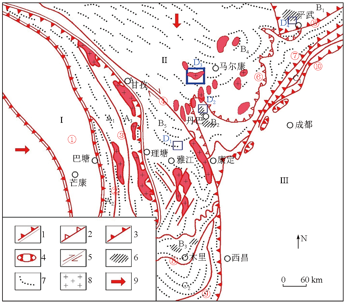
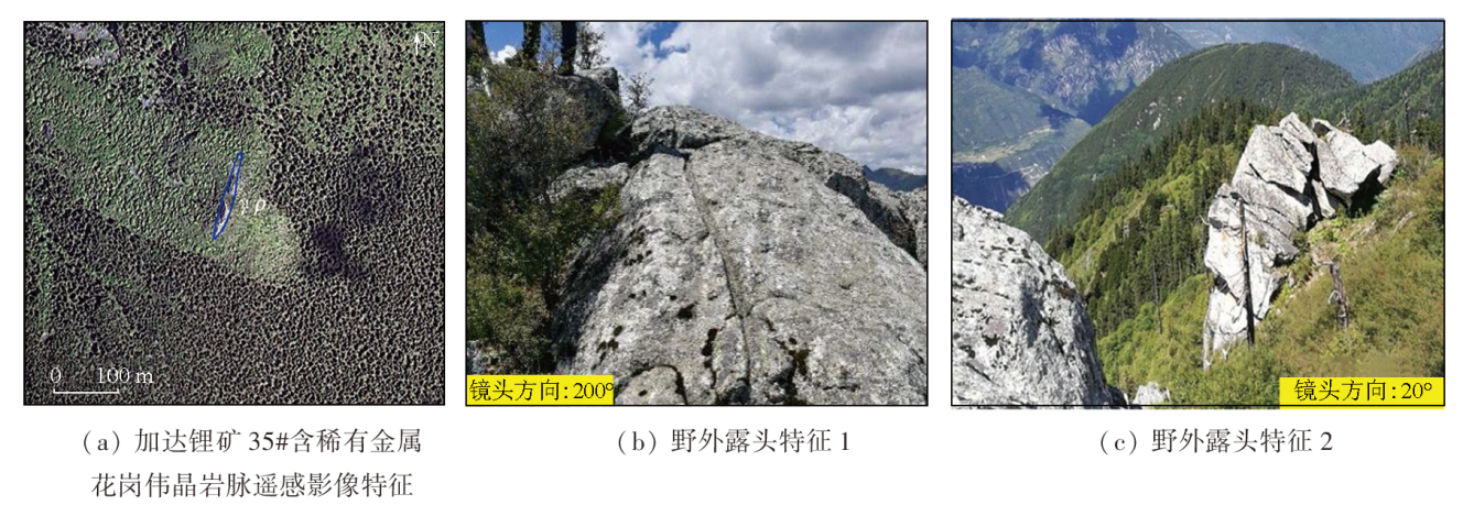
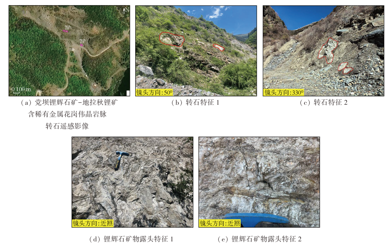
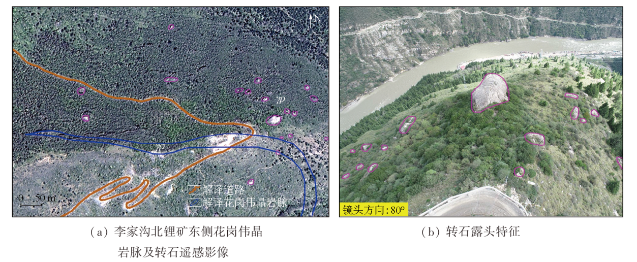
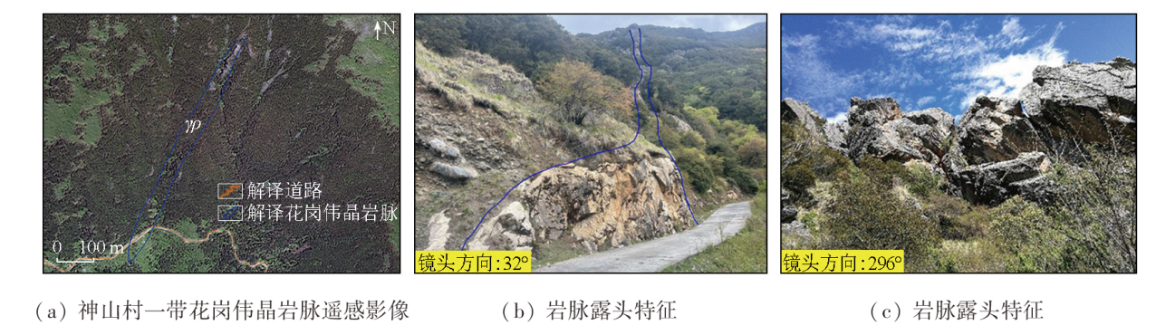
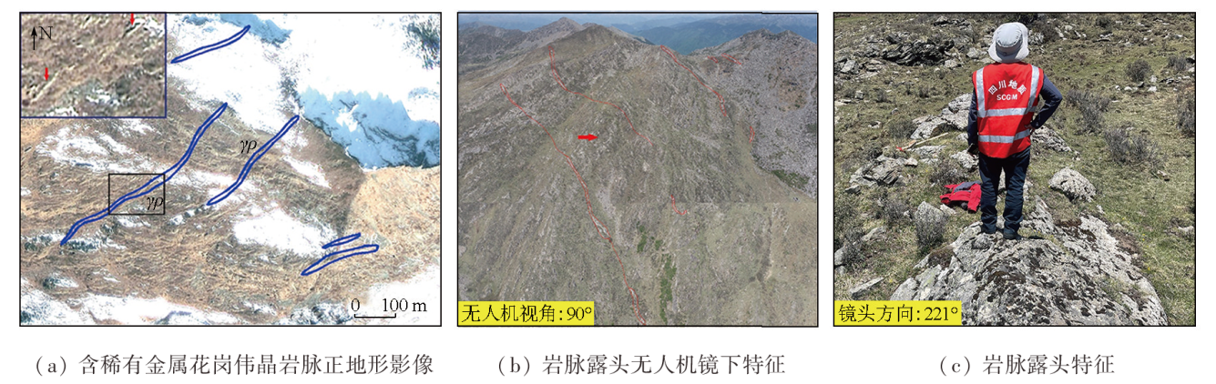
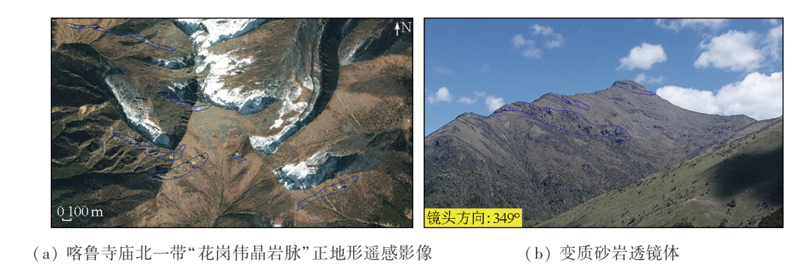
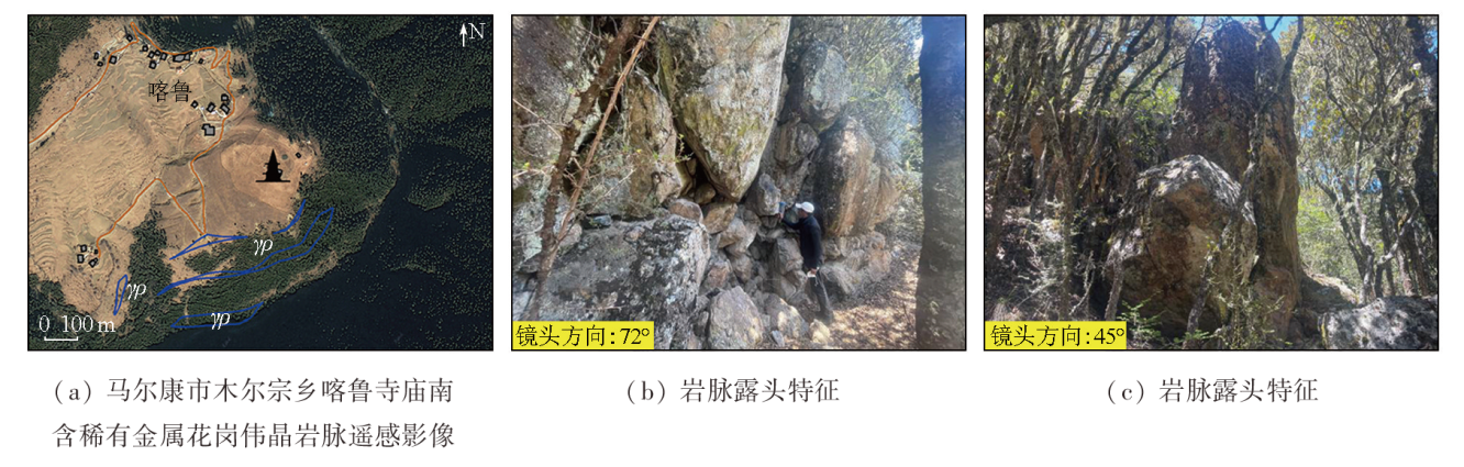
Abstract The Ke’eryin rare metal ore concentration area in the western Sichuan Basin (also referred to as the Ke’eryin ore concentration area), located in the eastern segment of the Songpan-Ganzi metallogenic belt, boasts abundant granitic pegmatite-hosted rare metal resources like lithium, niobium, beryllium, and tantalum. It stands as one of the most concentrated areas for hard-rock rare metal deposits in China, following the granitic pegmatite-type rare metal ore concentration areas in the Koktokay area in Altay in Xinjiang, and the Jiajika and Jiulong areas in the western Sichuan Basin. The Ke’eryin ore concentration area is characterized by tectonic denudation and deeply cut high mountains, resulting in inconvenient transportation, dense vegetation, and steep terrains. Consequently, most parts of the area are inaccessible to humans, hindering the implementation of traditional geological surveys. Based on the features and interpretation keys of high-resolution remote sensing images for ore-bearing granitic pegmatite veins in known deposits within the Ke’eryin ore concentration area, this study performed laboratory interpretation and partial field verification of these veins, revealing the distribution patterns and characteristics of granitic pegmatite veins in the area. Rare metal deposits hosted by granitic pegmatite veins intruded into weak structures such as fault zones and surrounding rock fractures within a range of 0 km to 5 km on the margin of the Ke’eryin complex rock mass. The exposed granitic pegmatite veins and boulders were identified as the most direct indicators for locating rare metal deposits. A prospecting method based on remote sensing geology was developed for highly vegetation-covered areas in the Ke’eryin ore concentration area, effectively addressing the limitations of traditional geological prospecting methods. Using the developed method, this study determined three critical prospecting areas in the northern and northwestern portions of the Ke’eryin complex rock mass, establishing them as the targets for subsequent strategic prospecting breakthroughs.
|
| Keywords
Ke’eryin rock mass
rare metal ore concentration area
remote sensing geology
granitic pegmatite vein
|
|
|
|
Issue Date: 09 May 2025
|
|
|
| [1] |
李建康. 川西典型伟晶岩型矿床的形成机理及其大陆动力学背景[D]. 北京: 中国地质大学(北京), 2006.
|
| [1] |
Li J K. Mineralizing mechanism and continental geodynamics of typical pegmatite deposits in western Sichuan,China[D]. Beijing: China University of Geosciences(Beijing), 2006.
|
| [2] |
岳相元, 张贻, 周雄, 等. 川西可尔因矿集区稀有金属矿床成矿规律与找矿方向[J]. 矿床地质, 2019, 38(4):867-876.
|
| [2] |
Yue X Y, Zhang Y, Zhou X, et al. Metallogenic regularity and prospecting direction of rare metal deposits in Keeryin ore concentration area,western Sichuan[J]. Mineral Deposits, 2019, 38(4):867-876.
|
| [3] |
王子平, 刘善宝, 马圣钞, 等. 四川阿坝州党坝超大型锂辉石矿床成矿规律及深部和外围找矿方向[J]. 地球科学, 2018, 43(6):2029-2041.
|
| [3] |
Wang Z P, Liu S B, Ma S C, et al. Metallogenic regularity,deep and periphery prospecting of dangba superlarge spodumene deposit in Aba,Sichuan Province[J]. Earth Science, 2018, 43(6):2029-2041.
|
| [4] |
郑艺龙, 许志琴, 高文琦, 等. 川西马尔康片麻岩穹隆与伟晶岩型锂矿的构造成因[J]. 地质学报, 2021, 95(10):3069-3084.
|
| [4] |
Zheng Y L, Xu Z Q, Gao W Q, et al. Tectonic genesis of the Markam gneiss dome and pegmatitic lithium deposits in western Sichuan Province[J]. Acta Geologica Sinica, 2021, 95(10):3069-3084.
|
| [5] |
王登红, 刘丽君, 侯江龙, 等. 初论甲基卡式稀有金属矿床“五层楼+地下室”勘查模型[J]. 地学前缘, 2017, 24(5):1-7.
doi: 10.13745/j.esf.yx.2017-1-1
|
| [5] |
Wang D H, Liu L J, Hou J L, et al. A preliminary review of the application of “Five levels+Basement” model for Jiajika-style rare metal deposits[J]. Earth Science Frontiers, 2017, 24(5):1-7.
|
| [6] |
刘善宝, 王成辉, 王登红, 等. 四川甲基卡锂矿伟晶岩转石分布区“3定2参”大比例尺填图法及其在青藏高原应用的意义[J]. 地质学报, 2020, 94(1):326-332.
|
| [6] |
Liu S B, Wang C H, Wang D H, et al. The “3D2R-BP” large scale mapping method for blocks of pegmatite in the Jajika deposit,western Sichuan,and significance of its application in the Qinghai-Tibet Plateau[J]. Acta Geologica Sinica, 2020, 94(1):326-332.
|
| [7] |
唐文周. 我国遥感地质工作的现状和近期展望[J]. 国土资源遥感, 1998, 10(2):24-32.doi:10.6046/gtzyyg.1998.02.04.
|
| [7] |
Tang W Z. Present situation and recent prospect of remote sensing geological work in China[J]. Remote Sensing for Land and Resources, 1998, 10(2):24-32.doi:10.6046/gtzyyg.1998.02.04.
|
| [8] |
熊盛青. 国土资源遥感技术应用现状与发展趋势[J]. 国土资源遥感, 2002, 14(1):1-5.doi:10.6046/gtzyyg.2002.01.01.
|
| [8] |
Xiong S Q. The application status and development trend of remote sensing technology in national land and resources[J]. Remote Sensing for Land and Resources, 2002, 14(1):1-5.doi:10.6046/gtzyyg.2002.01.01.
|
| [9] |
范玉海, 王辉, 杨兴科, 等. 基于高分辨率遥感数据的稀有金属矿化带勘查[J]. 国土资源遥感, 2018, 30(1):128-134.doi:10.6046/gtzyyg.2018.01.18.
|
| [9] |
Fan Y H, Wang H, Yang X K, et al. Application of high-resolution remote sensing technology to the prospecting for rare metal mineralization belt[J]. Remote Sensing for Land and Resources, 2018, 30(1):128-134.doi:10.6046/gtzyyg.2018.01.18.
|
| [10] |
张微, 金谋顺, 张少鹏, 等. 高分遥感卫星数据在东昆仑成矿带找矿预测中的应用[J]. 国土资源遥感, 2016, 28(2):112-119.doi:10.6046/gtzyyg.2016.02.18.
|
| [10] |
Zhang W, Jin M S, Zhang S P, et al. Application of high resolution remote sensing data to ore-prospecting prediction in East Kunlun metallogenic belt[J]. Remote Sensing for Land and Resources, 2016, 28(2):112-119.doi:10.6046/gtzyyg.2016.02.18.
|
| [11] |
姜琪, 代晶晶, 王登红, 等. 光学遥感在识别花岗伟晶岩型锂矿床中的应用[J]. 矿床地质, 2021, 40(4):793-804.
|
| [11] |
Jiang Q, Dai J J, Wang D H, et al. Application of optical remote sensing to identifying granite pegmatite lithium deposits[J]. Mineral Deposits, 2021, 40(4):793-804.
|
| [12] |
潘桂堂, 肖庆辉. 中国大地构造图(1∶2500000)[M]. 北京: 地质出版社, 2015.
|
| [12] |
Pan G T, Xiao Q H. Tectonic map of China(1∶2500000)[M]. Beijing: Geology Press, 2015.
|
| [13] |
许志琴, 侯立玮, 王宗秀. 中国松潘-甘孜造山带的造山过程[M]. 北京: 地质出版社, 1992.
|
| [13] |
Xu Z Q, Hou L W, Wang Z X. The Orogenic Process of the Songpan-Ganzi Belt in China[M]. Beijing: Geology Press, 1992.
|
| [14] |
许志琴, 王汝成, 赵中宝, 等. 试论中国大陆“硬岩型”大型锂矿带的构造背景[J]. 地质学报, 2018, 92(6):1091-1106.
|
| [14] |
Xu Z Q, Wang R C, Zhao Z B, et al. On the structural backgrounds of the large-scale “hard-rock type” lithium ore belts in China[J]. Acta Geologica Sinica, 2018, 92(6):1091-1106.
|
| [15] |
Deschamps F, Duchêne S, de Sigoyer J, et al. Coeval mantle-derived and crust-derived magmas forming two neighbouring plutons in the Songpan ganze accretionary orogenic wedge(SW China)[J]. Journal of Petrology, 2017, 58(11):2221-2256.
|
| [16] |
de Sigoyer J, Vanderhaeghe O, Duchêne S, et al. Generation and emplacement of Triassic granitoids within the Songpan Ganze accretionary-orogenic wedge in a context of slab retreat accommodated by tear faulting,Eastern Tibetan Plateau,China[J]. Journal of Asian Earth Sciences, 2014, 88:192-216.
|
| [17] |
时章亮, 张宏飞, 蔡宏明. 松潘造山带马尔康强过铝质花岗岩的成因及其构造意义[J]. 地球科学, 2009, 34(4):569-584.
|
| [17] |
Shi Z L, Zhang H F, Cai H M. Petrogenesis of strongly peraluminous granites in Markan area,Songpan fold belt and its tectonic implication[J]. Earth Science, 2009, 34(4):569-584.
|
| [18] |
张伟, 邹林, 范映武, 等. 四川金川县热达门锂辉石矿地质特征及矿床成矿模型浅析[J]. 四川地质学报, 2019, 39(s1):55-59.
|
| [18] |
Zhang W, Zou L, Fan Y W, et al. Geological characteristics and metallogenic model of Jedaias spodumene deposit in Jinchuan County,Sichuan Province[J]. Acta Geologica Sichuan, 2019, 39(s1):55-59.
|
| [19] |
李建康, 王登红, 付小方. 川西可尔因伟晶岩型稀有金属矿床的40Ar/39Ar年代及其构造意义[J]. 地质学报, 2006, 80(6):843-848.
|
| [19] |
Li J K, Wang D H, Fu X F. 40Ar/39Ar ages of the Keeryin pegmatite type rare metal deposit,western Sichuan,and its tectonic significances[J]. Acta Geologica Sinica, 2006, 80(6):843-848.
|
| [20] |
古城会. 四川省可尔因伟晶岩田东南密集区锂辉石矿床成矿规律[J]. 地质找矿论丛, 2014, 29(1):59-65.
|
| [20] |
Gu C H. Metallogenic regularity of spodumene deposits in the closely spaced pegmatite area in the southeastern Keeryin pegmatite field,Sichuan Province[J]. Contributions to Geology and Mineral Resources Research, 2014, 29(1):59-65.
|
| [21] |
庞博, 古城会, 李良波, 等. 四川省马尔康党坝锂辉石矿床地质特征及成因研究[J]. 四川有色金属, 2015(4):31-34.
|
| [21] |
Pang B, Gu C H, Li L B, et al. Geological characteristics and genesis of the spodumene deposit in Dangba,Barkam,Sichuan Province[J]. Sichuan Nonferrous Metals, 2015,(4):31-34.
|
| [22] |
景明, 邓涛. 马尔康白湾锂矿区地质特征及找矿标志[J]. 四川地质学报, 2016, 36(2):280-283.
|
| [22] |
Jing M, Deng T. Geological features and ore criteria of the Baiwan Li deposit in Barkam[J]. Acta Geologica Sichuan, 2016, 36(2):280-283.
|
| [23] |
饶魁元. 四川马尔康地拉秋锂矿床地质特征及找矿方向[J]. 四川有色金属, 2016 (1):54-57.
|
| [23] |
Rao K Y. The geological characteristics and ore exploration targeting of Dilaqiu lithium deposit in Maerkang county,Sichuan Pro-vince[J]. Sichuan Nonferrous Metals, 2016,(1):54-57.
|
| [24] |
马圣钞, 王登红, 刘善宝, 等. 川西可尔因锂矿田云母矿物化学及稀有金属成矿和找矿指示[J]. 矿床地质, 2019, 38(4):877-897.
|
| [24] |
Ma S C, Wang D H, Liu S B, et al. Mineral chemistry of micas from Ke’eryin pegmatite type lithium orefield in western Sichuan and its indication for rare metal mineralization and prospecting[J]. Mineral Deposits, 2019, 38(4):877-897.
|
| [25] |
费光春, 方兵. 川西可尔因矿田李家沟锂辉石矿床矿石组构特征[J]. 矿物学报, 2015, 35(s1):1000.
|
| [25] |
Fei G C, Fang B. Fabric characteristics of Lijiagou spodumene deposit ore in Kerin ore field,western Sichuan[J]. Acta Mineralogica Sinica, 2015, 35(s1):1000.
|
|
Viewed |
|
|
|
Full text
|
|
|
|
|
Abstract
|
|
|
|
|
Cited |
|
|
|
|
| |
Shared |
|
|
|
|
| |
Discussed |
|
|
|
|
 2025,
Vol. 37
2025,
Vol. 37