|
|
 |
|

|
|
|
Application of the space-air-ground investigation system in the identification and monitoring of geohazards in highly vegetation-covered mountain areas: A case study of Leshan City, Sichuan Province |
ZHOU Shengsen1( ), LI Weile1(), LU Huiyan1, REN Juan2, FU Hao2, LI Xueqing1, WANG Xincheng1, LI Yusen1, WEI Chunhao1 ), LI Weile1(), LU Huiyan1, REN Juan2, FU Hao2, LI Xueqing1, WANG Xincheng1, LI Yusen1, WEI Chunhao1 |
1. State Key Laboratory Geohazard Prevention and Geoenvironment Protection, Chengdu University of Technology, Chengdu 610059, China
2. Sichuan Institute of Land and Space Ecological Restoration and Geological Hazard Prevention, Chengdu 610081, China |
|
|
|
|
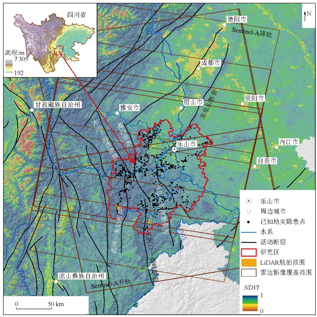
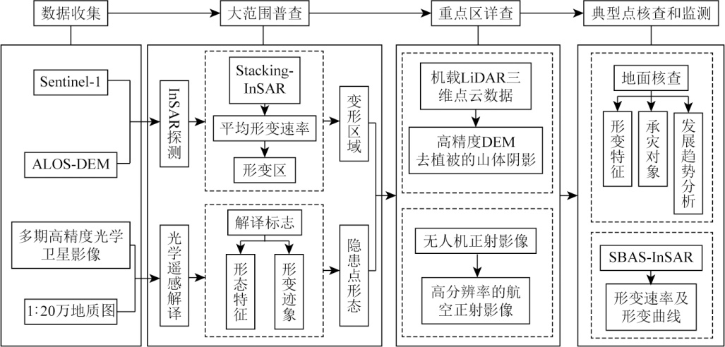
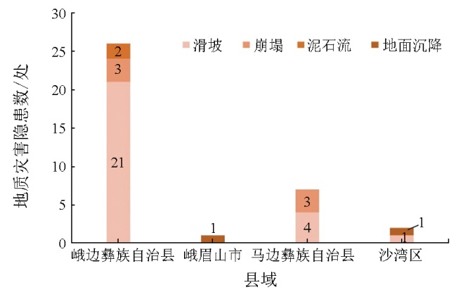
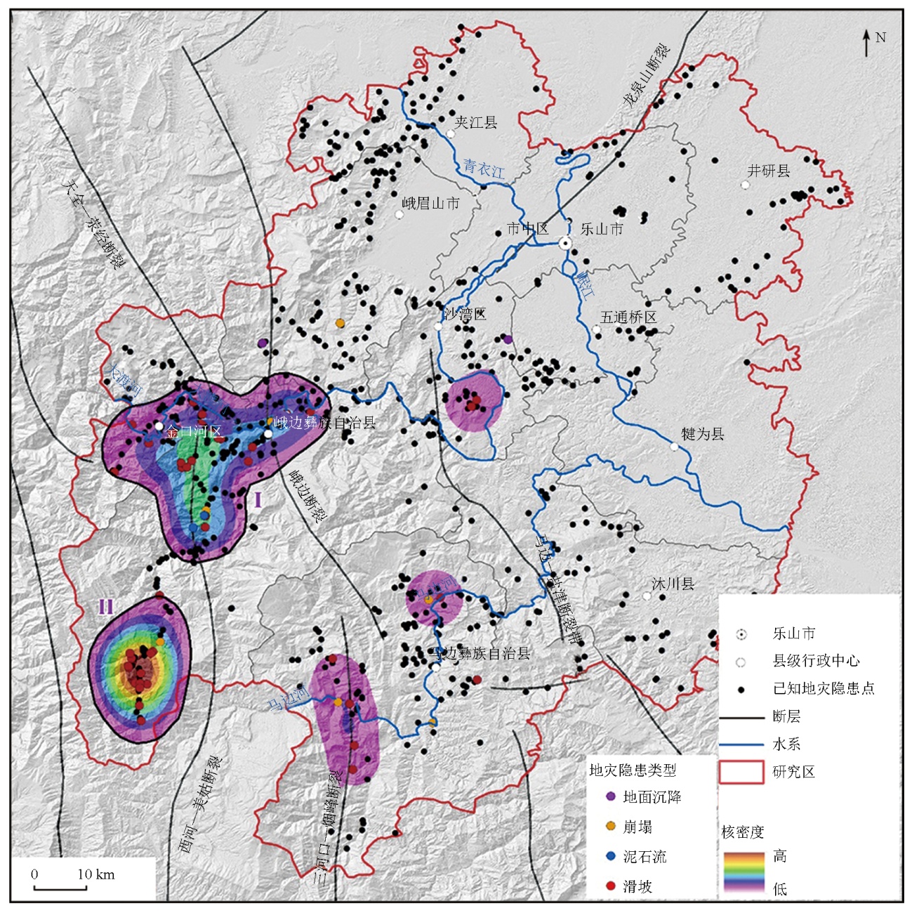
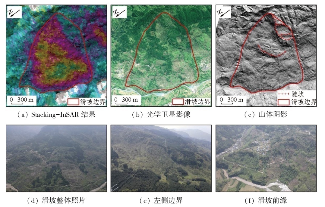
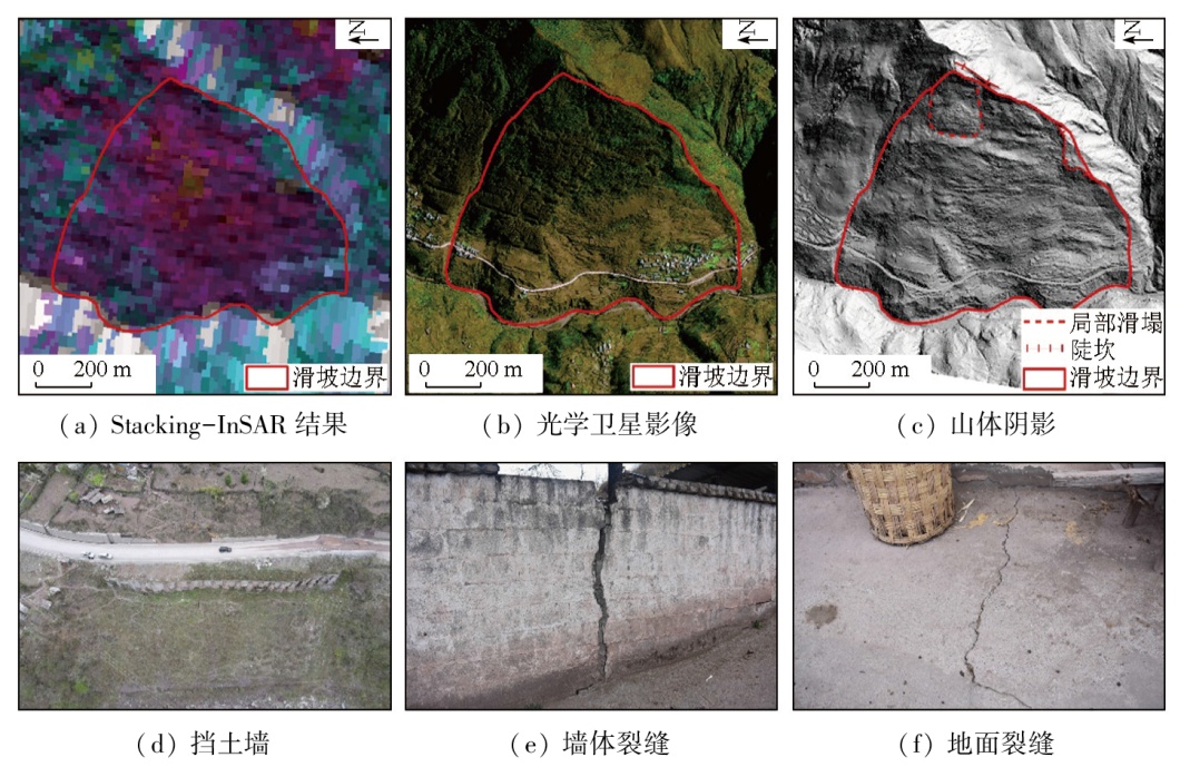
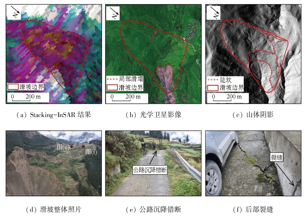
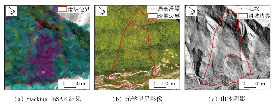
Abstract The space-air-ground investigation system has achieved remarkable results in the identification and monitoring demonstration work of geohazards. Leshan City in Sichuan Province, China, is a key zone for preventing and controlling geohazards within the demonstration area. The high vegetation cover and concentrated rainfall lead to the high concealment and sudden occurrence of geohazards in Leshan City, necessitating the identification and monitoring of geohazards in this city. Hence, under the guidance of the space-air-ground investigation system, this study explored the identification and monitoring of geohazards in the highly vegetation-covered mountain areas within Leshan City. The results indicate that 75 geohazards were identified in the study areas, with 51 confirmed through field verification, suggesting an identification accuracy rate of 68 %. Among them, 36 geohazards were newly identified. The geohazards were primarily concentrated in two areas, where 37 were identified, representing 72.5 % of the total geohazards in the study areas. Concerning techniques for identifying geohazards at different deformation stages of slopes, stacking-interferometric synthetic aperture radar (InSAR) can be employed to detect geohazards at the initial deformation stage of slopes. For slopes experiencing significant deformation within the detection range of InSAR, techniques like stacking-InSAR, high-resolution optical satellite imagery, and light detection and ranging (LiDAR) can all be used for geohazard identification. For highly vegetation-covered mountain areas, the LiDAR technique, which can be utilized to remove the effects of surface vegetation, combined with expert knowledge, can be used for geohazard identification. Additionally, remote sensing techniques face challenges in effectively identifying concealed geohazards.
|
| Keywords
geohazard
highly vegetation-covered mountain area
space-air-ground investigation system
identification and monitoring
Leshan City
|
|
|
|
Issue Date: 01 July 2025
|
|
|
| [1] |
Xu Q, Zhao B, Dai K R, et al. Remote sensing for landslide investigations:A progress report from China[J]. Engineering Geology, 2023,321:107156.
|
| [2] |
葛大庆. 地质灾害早期识别与监测预警中的综合遥感应用[J]. 城市与减灾, 2018(6):53-60.
|
| [2] |
Ge D Q. Comprehensive application of remote sensing in early identification,monitoring and early warning in geological disasters[J]. City and Disaster Reduction, 2018(6):53-60.
|
| [3] |
徐红. 地质灾害:由群防到技防——访自然资源部地质灾害防治技术指导中心首席科学家殷跃平[J]. 中国测绘, 2020(7):8-11.
|
| [3] |
Xu H. Geological disasters:From group prevention to technical prevention——Interview with Yin Yueping,chief scientist of Geological Disaster Prevention and Control Technical Guidance Center of Ministry of Natural Resources[J]. China Surveying and Mapping, 2020(7):8-11.
|
| [4] |
梁京涛, 赵聪, 马志刚. 多源遥感技术在地质灾害早期识别应用中的问题探讨——以西南山区为例[J]. 中国地质调查, 2022, 9(4):92-101.
|
| [4] |
Liang J T, Zhao C, Ma Z G. Application discussion on early identification of geohazards based on multi-source remote sensing technology:A case study on mountainous areas of southwestern China[J]. Geological Survey of China, 2022, 9(4):92-101.
|
| [5] |
陈舒. 点面双控探寻护佑生命之路[N]. 中国自然资源报,2023-05-08(003).
|
| [5] |
Chen S. The path to protecting life is explored through point-face dual control[N]. China Natural Resources News,2023-05-08(003).
|
| [6] |
许强. 对地质灾害隐患早期识别相关问题的认识与思考[J]. 武汉大学学报(信息科学版), 2020, 45(11):1651-1659.
|
| [6] |
Xu Q. Understanding and consideration of related issues in early identification of potential geohazards[J]. Geomatics and Information Science of Wuhan University, 2020, 45(11):1651-1659.
|
| [7] |
Yin Y P, Sun P, Zhang M, et al. Mechanism on apparent dip sli-ding of oblique inclined bedding rockslide at Jiweishan,Chongqing,China[J]. Landslides, 2011, 8(1):49-65.
|
| [8] |
Wu L Z, Shi J S, Xu Q. The rainfall-induced Wulipo rockslide,China:A modified model for rockslide initiation[J]. Environmental Earth Sciences, 2017, 76(14):497.
|
| [9] |
梁京涛, 成余粮, 王军, 等. 2013年7月10日四川省都江堰三溪村五里坡特大滑坡灾害遥感调查及成因机制浅析[J]. 工程地质学报, 2014, 22(6):1194-1203.
|
| [9] |
Liang J T, Cheng Y L, Wang J, et al. Remote sensing investigation and formation mechanism on Wulipo landslide of July 10,2013 in Sanxi Village,Dujiangyan,Sichuan Province[J]. Journal of Engineering Geology, 2014, 22(6):1194-1203.
|
| [10] |
Xing A G, Xu Q, Zhu Y Q, et al. 2014, The August 27,rock avalanche and related impulse water waves in Fuquan,Guizhou,China[J]. Landslides, 2016, 13(2):411-422.
|
| [11] |
Ouyang C J, Zhao W, Xu Q, et al. Failure mechanisms and characteristics of the 2016 catastrophic rockslide at Su Village,Lishui,China[J]. Landslides, 2018, 15(7):1391-1400.
|
| [12] |
刘传正. 浙江遂昌县苏村崩塌滑坡灾害[J]. 中国地质灾害与防治学报, 2016, 27(4):12.
|
| [12] |
Liu C Z. Collapse and landslide disaster in Sucun,Suichang County,Zhejiang Province[J]. The Chinese Journal of Geological Ha-zard and Control, 2016, 27(4):12.
|
| [13] |
Scaringi G, Fan X M, Xu Q, et al. Some considerations on the use of numerical methods to simulate past landslides and possible new failures:The case of the recent Xinmo landslide (Sichuan,China)[J]. Landslides, 2018, 15(7):1359-1375.
|
| [14] |
李华, 史文兵, 朱要强, 等. 贵州省水城县“7·23”灾难性滑坡形成机制研究[J]. 自然灾害学报, 2020, 29(6):188-198.
|
| [14] |
Li H, Shi W B, Zhu Y Q, et al. Study on the formation mechanism of “7·23” catastrophic landslide in Shuicheng County,Guizhou Province,China[J]. Journal of Natural Disasters, 2020, 29(6):188-198.
|
| [15] |
许强, 董秀军, 李为乐. 基于天-空-地一体化的重大地质灾害隐患早期识别与监测预警[J]. 武汉大学学报(信息科学版), 2019, 44(7):957-966.
|
| [15] |
Xu Q, Dong X J, Li W L. Integrated space-air-ground early detection,monitoring and warning system for potential catastrophic geohazards[J]. Geomatics and Information Science of Wuhan University, 2019, 44(7):957-966.
|
| [16] |
陈舒. 地灾隐患识别:寻找大地上的“潜伏者”[N]. 中国自然资源报,2021-05-10(003).
|
| [16] |
Chen S. Geohazards identification:Searching for the “lurkers” on the earth[N]. China Natural Resources News,2021-05-10(003).
|
| [17] |
李永建, 唐得胜, 马志刚. 四川省地质灾害防治形势及对策研究[J]. 四川地质学报, 2020, 40(4):676-679.
|
| [17] |
Li Y J, Tang D S, Ma Z G. A study of the situation and countermeasures of geohazard control in Sichuan Province[J]. Acta Geologica Sichuan, 2020, 40(4):676-679.
|
| [18] |
虎啸天, 娜子布林, 彭旭东, 等. 乐山市地质灾害发育特征及其防治形势分析[J]. 四川建材, 2017, 43(5):200-201.
|
| [18] |
Hu X T, Na Z, Peng X D, et al. Analysis on the characteristics of geological hazards developing and prevention situation in Leshan City[J]. Sichuan Building Materials, 2017, 43(5):200-201.
|
| [19] |
乔建平. 四川乐山地区红层滑坡特点研究[C]// 自然边坡稳定性分析暨华蓥山边坡变形趋势研讨会论文集. 重庆,1991:176-183.
|
| [19] |
Qiao J P. Characterization of red-layer landslides in the Leshan area,Sichuan[C]// Natural slope stability analysis and seminar on deformation trends of Huaying Mountain slopes.Chongqing, China,1991:176-183.
|
| [20] |
严映峰, 何朝阳, 解明礼, 等. 乐山市张村沟泥石流工程地质特征及成因机制分析[J]. 人民长江, 2021, 52(10):152-158.
|
| [20] |
Yan Y F, He C Y, Xie M L, et al. Analysis of engineering geological characteristics and formation mechanism of debris flow in Zhangcungou,Leshan City[J]. Yangtze River, 2021, 52(10):152-158.
|
| [21] |
王昌强. 乐山五通桥区滑坡破坏特征与演化机制研究[J]. 西部探矿工程, 2020, 32(12):20-23.
|
| [21] |
Wang C Q. Study on failure characteristics and evolution mechanism of Wutongqiao District landslide in Leshan[J]. West-China Exploration Engineering, 2020, 32(12):20-23.
|
| [22] |
赵娜, 钟家彬. 乐山市金口河区大渡河沿岸崩塌地质灾害发育特征[J]. 地质灾害与环境保护, 2017, 28(4):26-30.
|
| [22] |
Zhao N, Zhong J B. Development characteristics of the collapse along the banks of Dadu river at Jinkouhe area in Leshan[J]. Journal of Geological Hazards and Environment Preservation, 2017, 28(4):26-30.
|
| [23] |
张德, 钟家彬. 乐山市金口河区大渡河沿岸泥石流地质灾害发育特征[J]. 地质灾害与环境保护, 2017, 28(4):17-21.
|
| [23] |
Zhang D, Zhong J B. Development characteristics of the debris flow along the banks of Dadu river at Jinkouhe area in Leshan[J]. Journal of Geological Hazards and Environment Preservation, 2017, 28(4):17-21.
|
| [24] |
赵娜, 钟家彬, 杨东明. 乐山市金口河区大渡河沿岸滑坡地质灾害发育特征[J]. 地质灾害与环境保护, 2016, 27(2):10-14.
|
| [24] |
Zhao N, Zhong J B, Yang D M. Development characteristics of the landslide along the banks of Dadu River at Jinkouhe area in Leshan[J]. Journal of Geological Hazards and Environment Preservation, 2016, 27(2):10-14.
|
| [25] |
付豪, 李为乐, 陆会燕, 等. 基于“三查”体系的丹巴县滑坡隐患早期识别与监测[J]. 武汉大学学报(信息科学版), 2024, 49(5):734-746.
|
| [25] |
Fu H, Li W L, Lu H Y, et al. Early detection and monitoring of potential landslides in Danba County based on the space-air-ground investigation system[J]. Geomatics and Information Science of Wuhan University, 2024, 49(5):734-746.
|
| [26] |
刘国祥, 陈强, 罗小军, 等. InSAR原理与应用[M]. 北京: 科学出版社, 2019.
|
| [26] |
Liu G X, Chen Q, Luo X J, et al. Principle and application of InSAR[M]. Beijing: Science Press, 2019.
|
| [27] |
王治华. 滑坡遥感[M]. 北京: 科学出版社, 2012.
|
| [27] |
Wang Z H. Remote sensing for landslide[M]. Beijing: Science Press, 2012.
|
| [28] |
卓宝熙. 工程地质遥感判释与应用(第2版)[M]. 北京: 中国铁道出版社, 2011.
|
| [28] |
Zhuo B X.Remote sensing interpretation and application of geology engineering[M]. (2nd edition) Beijing: China Railway Publishing House, 2011.
|
| [29] |
Guo C, Xu Q, Dong X J, et al. Geohazard recognition and inventory mapping using airborne LiDAR data in complex mountainous areas[J]. Journal of Earth Science, 2021, 32(5):1079-1091.
|
| [30] |
Berardino P, Fornaro G, Lanari R, et al. A new algorithm for surface deformation monitoring based on small baseline differential SAR interferograms[J]. IEEE Transactions on Geoscience and Remote Sensing, 2002, 40(11):2375-2383.
|
|
Viewed |
|
|
|
Full text
|
|
|
|
|
Abstract
|
|
|
|
|
Cited |
|
|
|
|
| |
Shared |
|
|
|
|
| |
Discussed |
|
|
|
|
 2025,
Vol. 37
2025,
Vol. 37