|
|
|
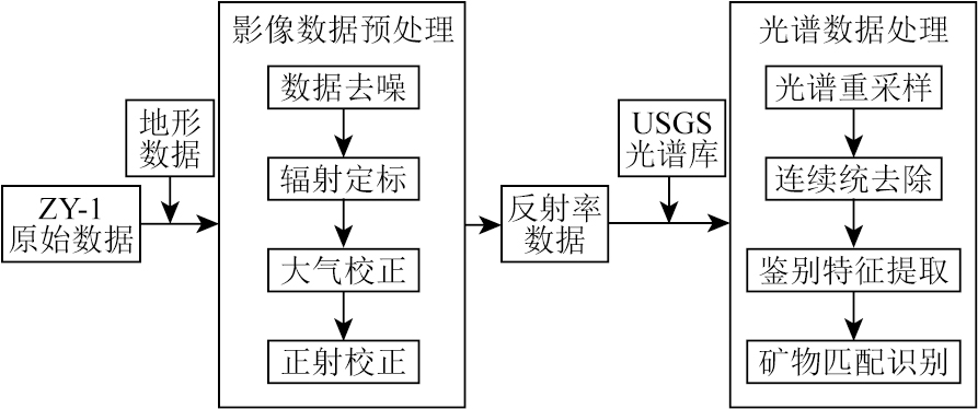
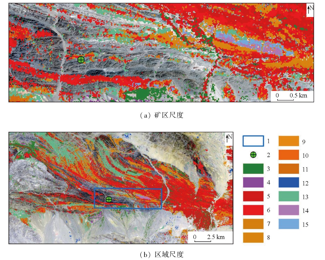
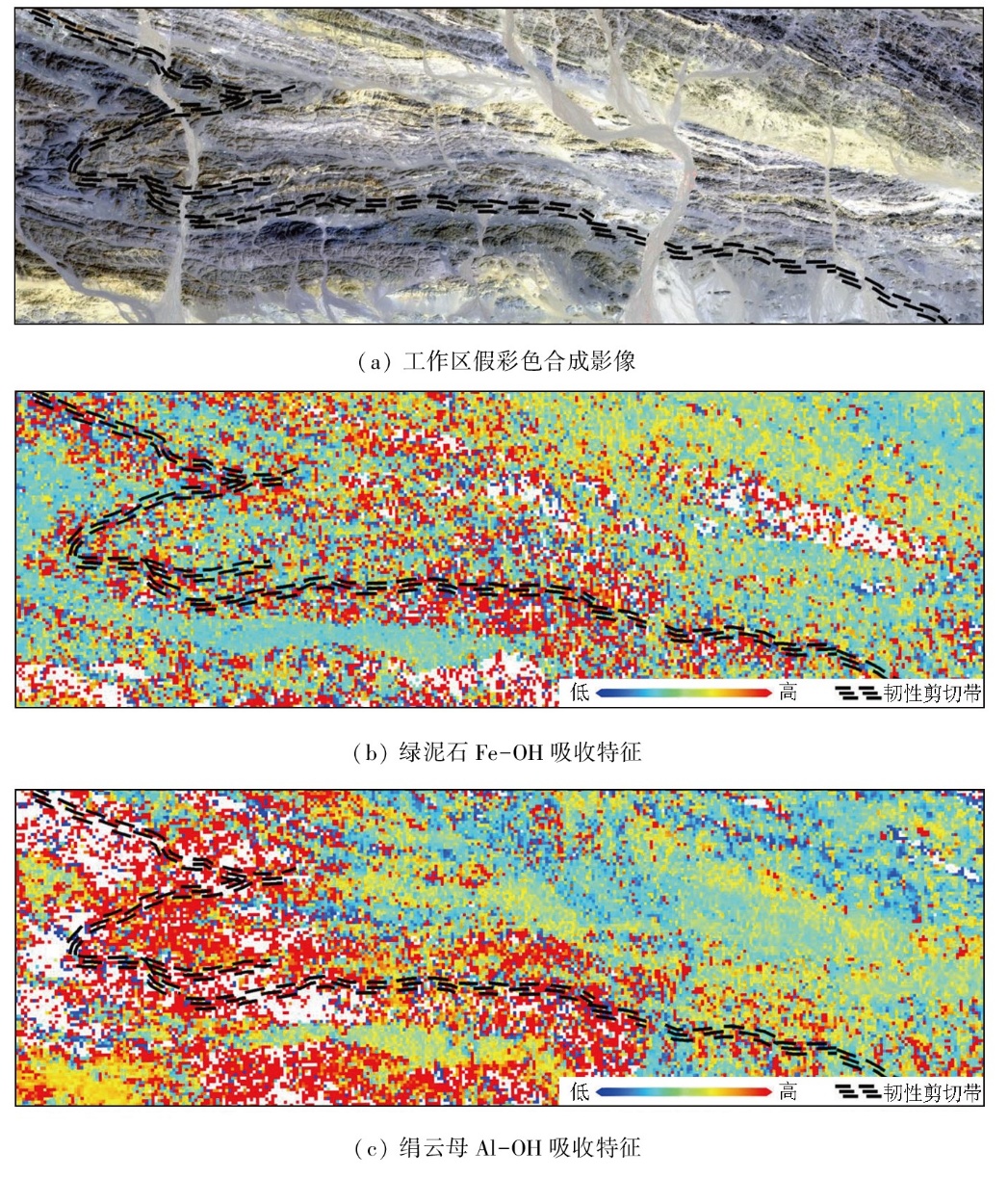
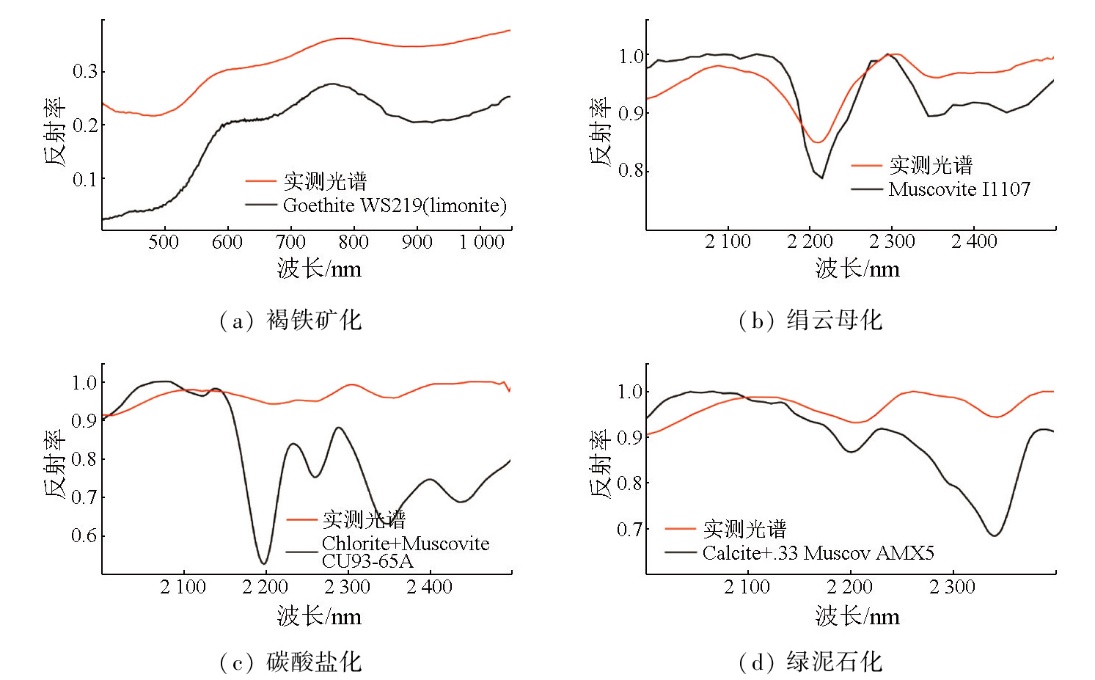
Abstract Hyperspectral remote sensing (HRS) technology,with its high spectral resolution and extensive spectral coverage,demonstrates significant potential in geological prospecting. Focusing on the Qianhongquan gold deposit in the Beishan orogenic belt,Gansu Province,this study conducted altered mineral mapping and component analysis,using HRS data from the AHSI sensor on the ZY-1 02D satellite and the self-developed hyperspectral mineral mapping technique,GeoAHSI,revealing their spatial distribution characteristics. Besides,ground-based spectral measurements were conducted on typical profiles to validate the spectral data,thereby assessing the reliability of the hyperspectral mineral mapping results. The results indicate that the primary altered minerals in the Qianhongquan gold deposit and its surrounding rocks include sericites (low-aluminum,medium-aluminum,high-aluminum,and iron-rich muscovites),calcites,dolomites,epidotes,and chlorites. Their distribution is closely related to ductile shear zones,with the distribution of sericites,chlorites,and epidotes being particularly significant within these zones. This spatial correlation provides critical indicators for regional prospecting. Additionally,it was observed that the 2 200 nm absorption feature of sericites and the 2 250 nm absorption feature of chlorites exhibit marked enrichment in silicon (Si) and iron (Fe) around ore bodies,which is closely correlated to the chemical compositions of the minerals. By enhancing the identification of weak spectral features,this study successfully applied HRS technology to mineral identification and spatial distribution analysis. These findings provide a scientific basis for further exploration of the Qianhongquan gold deposit and offer valuable references and guidance for the application of HRS in similar deposits.
|
| Keywords
hyperspectral remote sensing (HRS)
alerted mineral mapping
ZY-1 02D (Ziyuan-1 02D) satellite
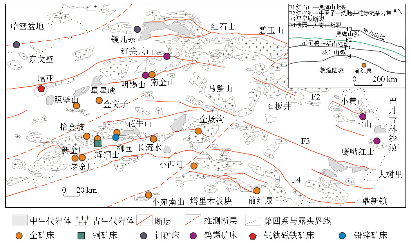
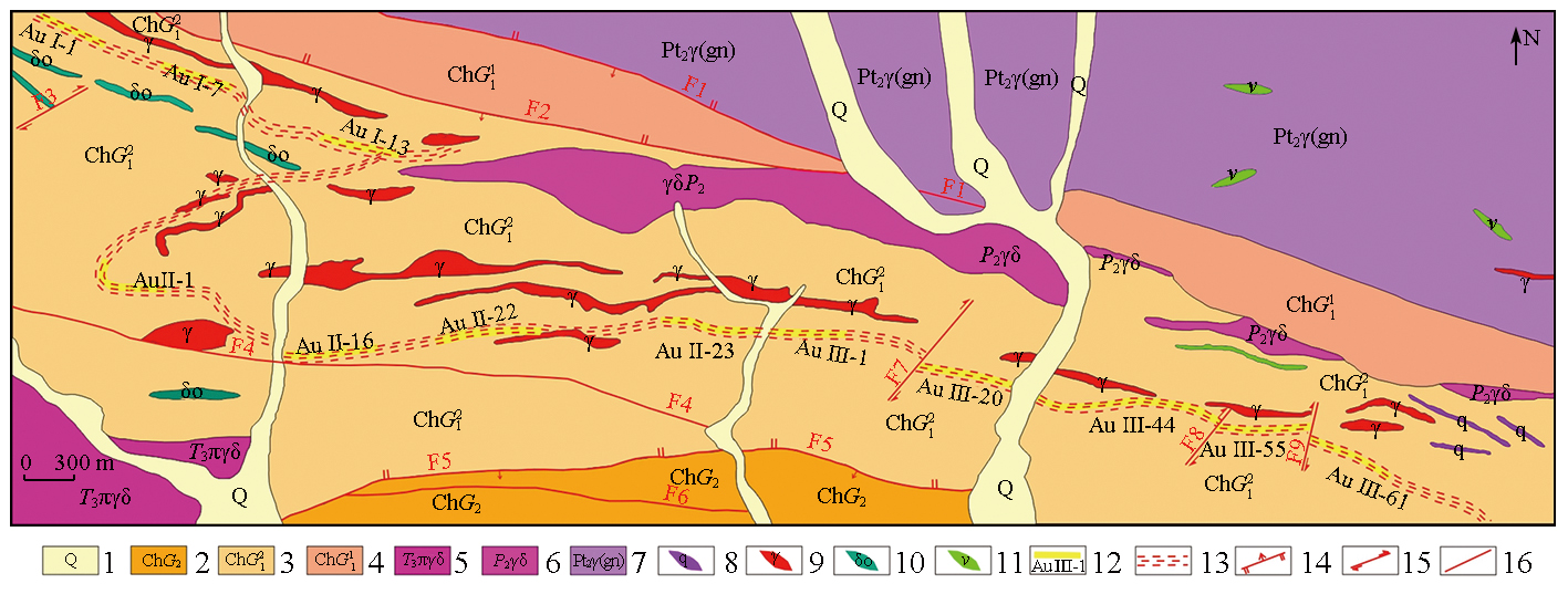
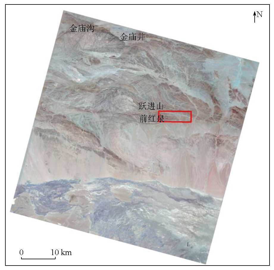
Qianhongquan gold deposit in Beishan orogenic belt
Gansu Province
|
|
|
|
Issue Date: 28 October 2025
|
|
|
| [1] |
杨国鹏, 余旭初, 冯伍法, 等. 高光谱遥感技术的发展与应用现状[J]. 测绘通报, 2008(10):1-4.
|
| [1] |
Yang G P, Yu X C, Feng W F, et al. The development and application of hyperspectral RS technology[J]. Bulletin of Surveying and Mapping, 2008(10):1-4.
|
| [2] |
甘甫平, 董新丰, 闫柏琨, 等. 光谱地质遥感研究进展[J]. 南京信息工程大学学报(自然科学版), 2018, 10(1):44-62.
|
| [2] |
Gan F P, Dong X F, Yan B K, et al. Research progress of spectro-metry geological remote sensing[J]. Journal of Nanjing University of Information Science & Technology (Natural Science Edition), 2018, 10(1):44-62.
|
| [3] |
代晶晶, 赵龙贤, 姜琪, 等. 热红外高光谱技术在地质找矿中的应用综述[J]. 地质学报, 2020, 94(8):2520-2533.
|
| [3] |
Dai J J, Zhao L X, Jiang Q, et al. Review of thermal-infrared spectroscopy applied in geological ore exploration[J]. Acta Geologica Sinica, 2020, 94(8):2520-2533.
|
| [4] |
孙雨, 赵英俊, 秦凯, 等. 基于航空成像高光谱数据的玉石矿找矿要素识别和找矿预测——以青海省纳赤台地区为例[J]. 地质论评, 2017, 63(s1):203-204.
|
| [4] |
Sun Y, Zhao Y J, Qin K, et al. Ore-forming factors and prospecting of jade ore using airborne hyperspectral data:Taken the nachitai area in Qinghai Province as an example[J]. Geological Review, 2017, 63(s1):203-204.
|
| [5] |
赵佳琪, 董新丰, 李娜, 等. 基于高光谱数据的甘肃花西山金矿蚀变特征分析与找矿预测应用[J]. 地质与勘探, 2023, 59(1):122-133.
|
| [5] |
Zhao J Q, Dong X F, Li N, et al. Alteration characteristics and prospecting prediction of the Huaxishan gold deposit in Gansu Province based on hyperspectral data[J]. Geology and Exploration, 2023, 59(1):122-133.
|
| [6] |
孙雨, 刘家军, 赵英俊, 等. 基于GF-5高光谱数据的蚀变矿物填图及地质应用——以甘肃省瓜州县花牛山地区为例[J]. 中国地质, 2022, 49(2):558-574.
|
| [6] |
Sun Y, Liu J J, Zhao Y J, et al. Alteration mineral mapping based on the GF-5 hyperspectral data and its geological application:An example of the Huaniushan area in Guazhou County of Gansu Province[J]. Geology in China, 2022, 49(2):558-574.
|
| [7] |
王聪聪, 陈川, 李云鹏, 等. 东天山帕尔岗塔格西斑岩铜矿高光谱遥感蚀变特征及其对找矿的指示意义[J]. 地质与勘探, 2023, 59(6):1171-1181.
|
| [7] |
Wang C C, Chen C, Li Y P, et al. Hyperspectral remote sensing alteration characteristics of the Paergangtagexi porphyry copper deposit in eastern Tianshan Mountains and their indicative significance for prospecting[J]. Geology and Exploration, 2023, 59(6):1171-1181.
|
| [8] |
孙雨, 刘家军, 翟德高, 等. 基于资源一号02D卫星高光谱数据的甘肃头吊泉-南大滩地区蚀变矿物填图及金矿化带识别[J]. 地质与勘探, 2022, 58(2):399-409.
|
| [8] |
Sun Y, Liu J J, Zhai D G, et al. Alteration minerals mapping and identification of gold mineralization belt based on ZY1-02D hyperspectral data in the Toudiaoquan-nandatan area,Gansu Province[J]. Geology and Exploration, 2022, 58(2):399-409.
|
| [9] |
赵志芳, 张新乐, 陈琪, 等. 普朗斑岩型铜矿区矿化蚀变特征矿物填图及找矿潜力分析:来自资源一号02D遥感卫星的证据[J]. 沉积与特提斯地质, 2022, 42(1):17-29.
|
| [9] |
Zhao Z F, Zhang X L, Chen Q, et al. Mapping of alteration minerals and prospecting potential analysis of Pulang porphyry copper deposit:Evidence from remote sensing data of Ziyuan-1 02D satellite[J]. Sedimentary Geology and Tethyan Geology, 2022, 42(1):17-29.
|
| [10] |
李根军, 杨雪松, 张兴, 等. ZY1-02D高光谱数据在地质矿产调查中的应用与分析[J]. 国土资源遥感, 2021, 33(2):134-140.doi:10.6046/gtzyyg.2020190.
|
| [10] |
Li G J, Yang X S, Zhang X, et al. Application and analysis of ZY1-02D hyperspectral data in geological and mineral survey[J]. Remote Sensing for Land and Resources, 2021, 33(2):134-140.doi:10.6046/gtzyyg.2020190.
|
| [11] |
江思宏, 聂凤军, 胡朋, 等. 北山地区岩浆活动与金矿成矿作用关系探讨[J]. 矿床地质, 2006, 25(s1):269-272.
|
| [11] |
Jiang S H, Nie F J, Hu P, et al. Discussion on the relationship of magmatism and gold metallogeny in Beishan mountain area[J]. Mineral Deposits, 2006, 25(s1):269-272.
|
| [12] |
Pan X, Liu W, Hou Z. Ore-forming fluids as sampled by sulfide- and quartz-hosted fluid inclusions in the Jinwozi lode gold deposit,eastern Tianshan Mountains of China[J]. Resource Geology, 2014, 64(3):183-208.
|
| [13] |
俞胜, 赵斌斌, 贾轩, 等. 北山造山带南缘一条山北闪长岩地球化学、年代学特征及其构造意义[J]. 西北地质, 2022, 55(4):267-279.
|
| [13] |
Yu S, Zhao B B, Jia X, et al. Geochemistry,geochronology characteristics and tectonic significance of yitiaoshan diorite in the southern margin of Beishan Orogenic Belt[J]. Northwestern Geology, 2022, 55(4):267-279.
|
| [14] |
江彪, 王登红, 马玉波, 等. 北山及其相邻地区主要矿床类型、找矿新进展及方向[J]. 地质学报, 2022, 96(6):2206-2216.
|
| [14] |
Jiang B, Wang D H, Ma Y B, et al. Main deposit types,new deve-lopments and new directions of prospecting in Beishan region and its adjacent areas[J]. Acta Geologica Sinica, 2022, 96(6):2206-2216.
|
| [15] |
袁伟恒, 顾雪祥, 章永梅, 等. 甘肃北山地区小西弓金矿床成矿流体性质及矿床成因[J]. 现代地质, 2020, 34(3):554-568.
|
| [15] |
Yuan W H, Gu X X, Zhang Y M, et al. Properties of ore-forming fluids and genesis of the xiaoxigong gold deposit in the Beishan Region,Gansu Province[J]. Geoscience, 2020, 34(3):554-568.
|
| [16] |
丁书宏. 甘肃北山前红泉金矿床绢云母40Ar-39Ar年龄及其地质意义[J]. 黄金科学技术, 2021, 29(2):173-183.
doi: 10.11872/j.issn.1005-2518.2021.02.039
|
| [16] |
Ding S H. 40Ar-39Ar age of sericite and its geological significance in Qianhongquan gold deposit,Beishan area,Gansu Province[J]. Gold Science and Technology, 2021, 29(2):173-183.
|
| [17] |
王玉玺, 马涛, 张愿宁, 等. 甘肃北山南带地质找矿新进展与找矿方向[J]. 新疆地质, 2023, 41(s1):35.
|
| [17] |
Wang Y X, Ma T, Zhang Y N, et al. New progress and prospecting direction of geological prospecting in the southern belt of Beishan,Gansu Province[J]. Xinjiang Geology, 2023, 41(s1):35.
|
| [18] |
杨镇熙, 丁书宏, 张晶, 等. 甘肃北山南带前红泉金矿的发现及其找矿意义[J]. 西北地质, 2023, 56(6):274-284.
|
| [18] |
Yang Z X, Ding S H, Zhang J, et al. The discovery and prospecting significance of the Qianhongquan gold deposit in the south Beishan Orogenic Belt,Gansu Province,China[J]. Northwestern Geology, 2023, 56(6):274-284.
|
| [19] |
张晶, 杨镇熙, 陈世明, 等. 甘肃北山南带发现前红泉大型金矿床(30.6吨)[J]. 中国地质, 2024, 51(4):1443-1444.
|
| [19] |
Zhang J, Yang Z X, Chen S M, et al. Qianhongquan large gold deposit (30.6 tons) was discovered in the southern belt of Beishan,Gansu Province[J]. China Industrial Economics, 2024, 51(4):1443-1444.
|
| [20] |
韩月, 柯樱海, 王展鹏, 等. 资源一号02D卫星高光谱数据黄河三角洲湿地景观分类[J]. 遥感学报, 2023, 27(6):1387-1399.
|
| [20] |
Han Y, Ke Y H, Wang Z P, et al. Classification of the Yellow River Delta wetland landscape based on ZY-1 02D hyperspectral imagery[J]. National Remote Sensing Bulletin, 2023, 27(6):1387-1399.
|
| [21] |
Clark R N, Swayze G A, Livo K E, et al. Imaging spectroscopy:Earth and planetary remote sensing with the USGS Tetracorder and expert systems[J]. Journal of Geophysical Research:Planets, 2003, 108(E12):5131.
|
| [22] |
Kokaly R F, King T V V, Hoefen T M. Surface mineral maps of Afghanistan derived from HyMap imaging spectrometer data,version 2[R]. New York: U. S.Geological Survey Data, 2013.
|
| [23] |
王润生, 甘甫平, 闫柏琨, 等. 高光谱矿物填图技术与应用研究[J]. 国土资源遥感, 2010, 22(1):1-13.doi:10.6046/gtzyyg.2010.01.01.
|
| [23] |
Wang R S, Gan F P, Yan B K, et al. Hyperspectral mineral mapping and its application[J]. Remote Sensing for Land and Resources, 2010, 22(1):1-13.doi:10.6046/gtzyyg.2010.01.01.
|
| [24] |
Swayze G A, Clark R N, Goetz A F H, et al. Mapping advanced argillic alteration at cuprite,Nevada,using imaging spectroscopy[J]. Economic Geology, 2014, 109(5):1179-1221.
|
| [25] |
de Caritat P, Hutcheon I, Walshe J L. Chlorite geothermometry:A review[J]. Clays and Clay Minerals, 1993, 41(2):219-239.
|
| [26] |
Chinchilla D, Ortega L, Piña R, et al. The Patricia Zn-Pb-Ag epithermal ore deposit:An uncommon type of mineralization in northeastern Chile[J]. Ore Geology Reviews, 2016, 73:104-126.
|
|
Viewed |
|
|
|
Full text
|
|
|
|
|
Abstract
|
|
|
|
|
Cited |
|
|
|
|
| |
Shared |
|
|
|
|
| |
Discussed |
|
|
|
|
 2025,
Vol. 37
2025,
Vol. 37
 ), LI Shijie1(