|
|
 |
|

|
|
|
Dynamic changes in the landscape connectivity in Shenzhen City determined based on the long time series of remote sensing data |
TANG Wenkui1,2( ), YU Lu2(), ZHOU Weiqi1, YUE Jun2, ZHOU Zheng2 ), YU Lu2(), ZHOU Weiqi1, YUE Jun2, ZHOU Zheng2 |
1. State Key Laboratory of Urban and Regional Ecology, Research Center for Eco-Environmental Sciences, Chinese Academy of Sciences, Beijing 100085, China
2. Urban Planning and Design Institute of Shenzhen, Shenzhen 518028, China |
|
|
|
|
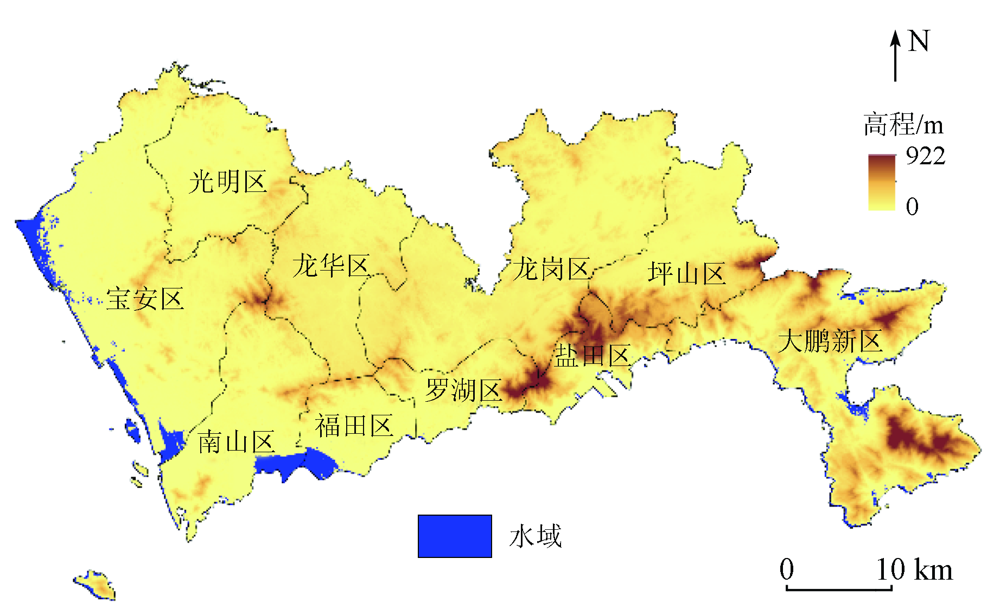
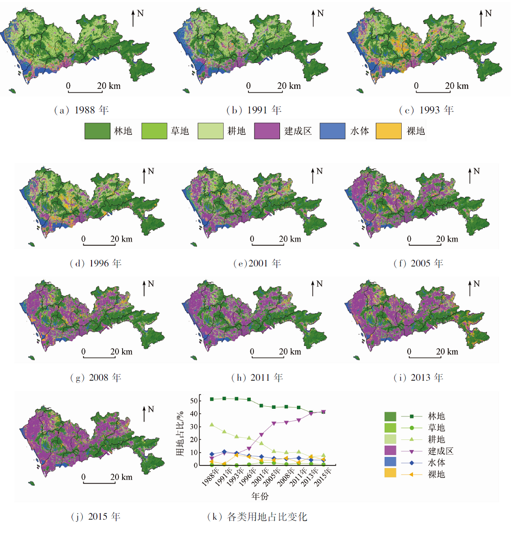
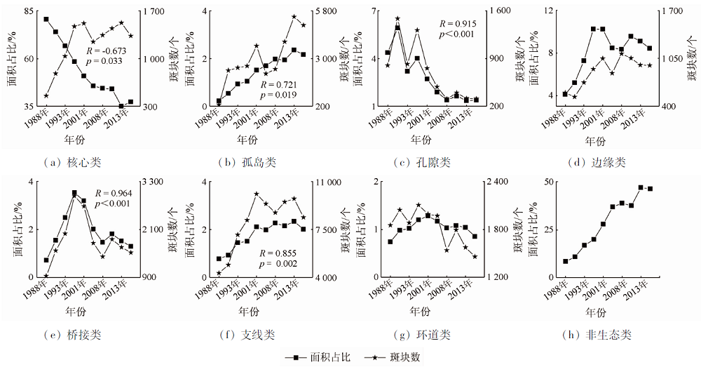
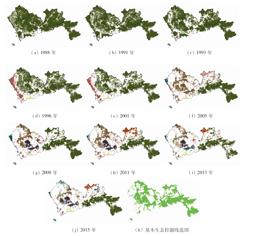
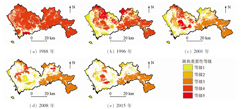
Abstract In the past 30 years, the land use in Shenzhen City has changed dramatically until it is almost saturated now. Using the morphological spatial pattern analysis (MSPA) and the graph theory, this study quantitatively analyzed the landscape connectivity of ecological land in Shenzhen based on ten phases of remote sensing images for land cover or use from 1988 to 2015. The results show that the cultivated land was the main land source in various periods of Shenzhen’s rapid urbanization, while the proportion of forest land used for urban development had risen since 2005. For Shenzhen’s landscape connectivity from 1988 to 2015, the equivalent connected area (ECA) of the ecological land decreased by 1 175.4 km2, and the degree of network connectivity (DOC) decreased by 43.51%. Since the delineation of Shenzhen’s basic ecological control boundary in 2005, the pace of urban habitat degradation has slowed down but the ECA of the ecological land had still been gradually eroded at a rate of 11.9 km2 per year. The analysis of the importance of ecological patches shows that areas like the Yangtai Mountain and Tanglang Mountain are key ecological nodes for landscape connectivity and should be protected with greater efforts.
|
| Keywords
landscape connectivity
graph theory
morphological spatial pattern analysis (MSPA)
remote sensing image of land cover or use
Shenzhen City
|
|
|
|
Corresponding Authors:
YU Lu
E-mail: tangwk@upr.cn;yul@upr.cn
|
|
Issue Date: 21 September 2022
|
|
|
| [1] |
Cotter M, Häuser I, Harich F K, et al. Biodiversity and ecosystem services:A case study for the assessment of multiple species and functional diversity levels in a cultural landscape[J]. Ecological Indicators, 2017, 75:111-117.
doi: 10.1016/j.ecolind.2016.11.038
url: https://linkinghub.elsevier.com/retrieve/pii/S1470160X16306860
|
| [2] |
Liu W, Hughes A C, Bai Y, et al. Using landscape connectivity tools to identify conservation priorities in forested areas and potential restoration priorities in rubber plantation in Xishuangbanna,Southwest China[J]. Landscape Ecology, 2020, 35(2):389-402.
doi: 10.1007/s10980-019-00952-2
url: https://doi.org/10.1007/s10980-019-00952-2
|
| [3] |
Acevedo M A, Sefair J A, Smith J C, et al. Conservation under uncertainty:Optimal network protection strategies for worst-case disturbance events[J]. Journal of Applied Ecology, 2015, 52(6):1588-1597.
doi: 10.1111/1365-2664.12532
url: https://onlinelibrary.wiley.com/doi/10.1111/1365-2664.12532
|
| [4] |
齐珂, 樊正球. 基于图论的景观连接度量化方法应用研究——以福建省闽清县自然森林为例[J]. 生态学报, 2016, 36(23):7580-7593.
|
| [4] |
Qi K, Fan Z Q. Evaluation method for landscape connectivity based on graph theory:A case study of natural forests in Minqing County,Fujian Province[J]. Acta Ecologica Sinica, 2016, 36(23):7580-7593.
|
| [5] |
Wang L, Young S S, Wang W, et al. Conservation priorities of forest ecosystems with evaluations of connectivity and future threats:Implications in the Eastern Himalaya of China[J]. Biological Conservation, 2016, 195:128-135.
doi: 10.1016/j.biocon.2015.12.044
url: https://linkinghub.elsevier.com/retrieve/pii/S0006320715302238
|
| [6] |
Shanthala D B S, Murthy M S R, Debnath B, et al. Forest patch connectivity diagnostics and prioritization using graph theory[J]. Ecological Modelling, 2013, 251:279-287.
doi: 10.1016/j.ecolmodel.2012.12.022
url: https://linkinghub.elsevier.com/retrieve/pii/S0304380013000057
|
| [7] |
Baranyi G, Saura S, Podani J, et al. Contribution of habitat patches to network connectivity:Redundancy and uniqueness of topological indices[J]. Ecological Indicators, 2011, 11(5):1301-1310.
doi: 10.1016/j.ecolind.2011.02.003
url: https://linkinghub.elsevier.com/retrieve/pii/S1470160X11000379
|
| [8] |
Saura S, Pascual-Hortal L. A new habitat availability index to integrate connectivity in landscape conservation planning:Comparison with existing indices and application to a case study[J]. Landscape and Urban Planning, 2007, 83(2):91-103.
doi: 10.1016/j.landurbplan.2007.03.005
url: https://linkinghub.elsevier.com/retrieve/pii/S0169204607000709
|
| [9] |
Saura S, Torné J. Conefor Sensinode 2.2:A software package for quantifying the importance of habitat patches for landscape connectivity[J]. Environmental Modelling and Software, 2009, 24(1):135-139.
doi: 10.1016/j.envsoft.2008.05.005
url: https://linkinghub.elsevier.com/retrieve/pii/S1364815208000959
|
| [10] |
Vogt P, Riitters K. GuidosToolbox:Universal digital image object analysis[J]. European Journal of Remote Sensing, 2017, 50(1):352-361.
doi: 10.1080/22797254.2017.1330650
url: https://www.tandfonline.com/doi/full/10.1080/22797254.2017.1330650
|
| [11] |
陈昕, 彭建, 刘焱序, 等. 基于“重要性—敏感性—连通性”框架的云浮市生态安全格局构建[J]. 地理研究, 2017, 36(3):471-484.
doi: 10.11821/dlyj201703006
|
| [11] |
Chen X, Peng J, Liu Y X, et al. Constructing ecological security patterns in Yunfu City based on the framework of importance-sensitivity-connectivity[J]. Geographical Research, 2017, 36(3):471-484.
|
| [12] |
倪庆琳, 侯湖平, 丁忠义, 等. 基于生态安全格局识别的国土空间生态修复分区——以徐州市贾汪区为例[J]. 自然资源学报, 2020, 35(1):204-216.
|
| [12] |
Ni Q L, Hou H P, Ding Z Y, et al. Ecological remediation zoning of territory based on the ecological security pattern recognition:Taking Jiawang District of Xuzhou City as an example[J]. Journal of Natural Resources, 2020, 35(1):204-216.
doi: 10.31497/zrzyxb.20200117
url: http://www.jnr.ac.cn/EN/10.31497/zrzyxb.20200117
|
| [13] |
王博娅, 刘志成. 北京市海淀区绿地结构功能性连接分析与构建策略研究[J]. 景观设计学, 2019, 7(1):34-51.
|
| [13] |
Wang B Y, Liu Z C. Functional connectivity analyses and construction strategies of the structure of green space network in Haidian District of Beijing[J]. Landscape Architecture Frontiers, 2019, 7(1):34-51.
doi: 10.15302/J-LAF-20190104
url: http://journal.hep.com.cn/laf/EN/10.15302/J-LAF-20190104
|
| [14] |
吴健生, 刘洪萌, 黄秀兰, 等. 深圳市生态用地景观连通性动态评价[J]. 应用生态学报, 2012, 23(9):2543-2549.
|
| [14] |
Wu J S, Liu H M, Huang X L, et al. Dynamic evaluation on landscape connectivity of ecological land:A case study of Shenzhen,Guangdong Province of South China[J]. Chinese Journal of Applied Ecology, 2012, 23(9):2543-2549.
|
| [15] |
曹翊坤, 付梅臣, 谢苗苗, 等. 基于LSMM与MSPA的深圳市绿色景观连通性研究[J]. 生态学报, 2015, 35(2):526-536.
|
| [15] |
Cao Y K, Fu M C, Xie M M, et al. Landscape connectivity dynamics of urban green landscape based on morphological spatial pattern analysis (MSPA) and linear spectral mixture model (LSMM) in Shenzhen[J]. Acta Ecologica Sinica, 2015, 35(2):526-536.
|
| [16] |
Dou P, Chen Y. Dynamic monitoring of land-use/land-cover change and urban expansion in Shenzhen using Landsat imagery from 1988 to 2015[J]. International Journal of Remote Sensing, 2017, 38(19):5388-5407.
doi: 10.1080/01431161.2017.1339926
url: https://www.tandfonline.com/doi/full/10.1080/01431161.2017.1339926
|
| [17] |
Velázquez J, Gutiérrez J, Hernando A, et al. Evaluating landscape connectivity in fragmented habitats:Cantabrian capercaillie (tetrao urogallus cantabricus) in Northern Spain[J]. Forest Ecology and Management, 2017, 389:59-67.
doi: 10.1016/j.foreco.2016.12.006
url: https://linkinghub.elsevier.com/retrieve/pii/S0378112716307459
|
| [18] |
Soille P, Vogt P. Morphological segmentation of binary patterns[J]. Pattern Recognition Letters, 2009, 30(4):456-459.
doi: 10.1016/j.patrec.2008.10.015
url: https://linkinghub.elsevier.com/retrieve/pii/S0167865508003267
|
| [19] |
朱强, 俞孔坚, 李迪华. 景观规划中的生态廊道宽度[J]. 生态学报, 2005, 25(9):2406-2412.
|
| [19] |
Zhu Q, Yu K J, Li D H. The width of ecological corridor in landscape planning[J]. Acta Ecologica Sinica, 2005, 25(9):2406-2412.
|
| [20] |
史芳宁, 刘世梁, 安毅, 等. 城市化背景下景观破碎化及连接度动态变化研究——以昆明市为例[J]. 生态学报, 2020, 40(10):3303-3314.
|
| [20] |
Shi F N, Liu S L, An Y, et al. Changes of landscape fragmentation and connectivity with urbanization:A case study of Kunming City[J]. Acta Ecologica Sinica, 2020, 40(10):3303-3314.
|
| [21] |
Saura S, Rubio L. A common currency for the different ways in which patches and links can contribute to habitat availability and connectivity in the landscape[J]. Ecography, 2010, 33(3):523-537.
|
| [22] |
于亚平, 尹海伟, 孔繁花, 等. 南京市绿色基础设施网络格局与连通性分析的尺度效应[J]. 应用生态学报, 2016, 27(7):2119-2127.
doi: 10.13287/j.1001-9332.201607.006
|
| [22] |
Yu Y P, Yin H W, Kong F H, et al. Scale effect of Nanjing urban green infrastructure network pattern and connectivity analysis[J]. Chinese Journal of Applied Ecology, 2016, 27(7):2119-2127.
|
| [23] |
Yin D, Leroux S J, He F. Methods and models for identifying thresholds of habitat loss[J]. Ecography, 2017, 40(1):131-143.
doi: 10.1111/ecog.02557
url: https://onlinelibrary.wiley.com/doi/10.1111/ecog.02557
|
| [24] |
邓金杰, 黄伟坚. 城市生态用地管控:问题及规划管理建议——以深圳市为例[J]. 城市观察, 2018(3):131-138.
|
| [24] |
Deng J J, Huang W J. Problems and suggestions on urban ecological land use control:A case study of Shenzhen[J]. Urban Insight, 2018(3):131-138.
|
| [25] |
张甜, 王仰麟, 刘焱序, 等. 1987—2015年深圳市主城区景观演变过程多时相识别[J]. 地理学报, 2016, 71(12):2170-2184.
doi: 10.11821/dlxb201612008
|
| [25] |
Zhang T, Wang Y L, Liu Y X, et al. Multi-temporal detection of landscape evolution in western Shenzhen City during 1987—2015[J]. Acta Geographica Sinica, 2016, 71(12):2170-2184.
|
| [26] |
吴健生, 黄乔, 曹祺文. 深圳市基本生态控制线划定对生态系统服务价值的影响[J]. 生态学报, 2018, 38(11):3756-3765.
|
| [26] |
Wu J S, Huang Q, Cao Q W. Effects of basic ecological control line policy on ecosystem services value in Shenzhen[J]. Acta Ecologica Sinica, 2018, 38(11):3756-3765.
|
|
Viewed |
|
|
|
Full text
|
|
|
|
|
Abstract
|
|
|
|
|
Cited |
|
|
|
|
| |
Shared |
|
|
|
|
| |
Discussed |
|
|
|
|
 2022,
Vol. 34
2022,
Vol. 34