|
|
|
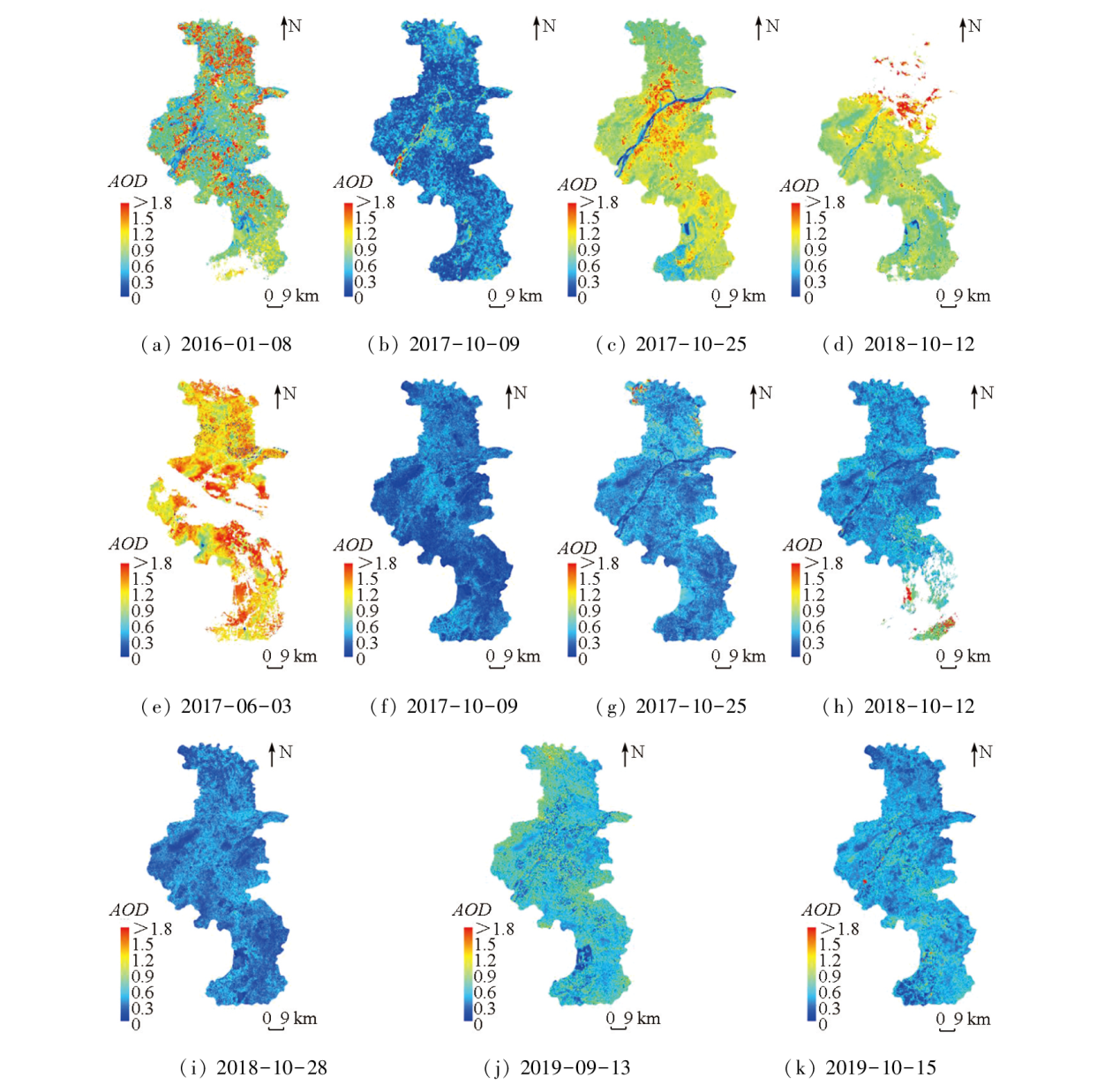
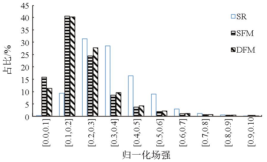
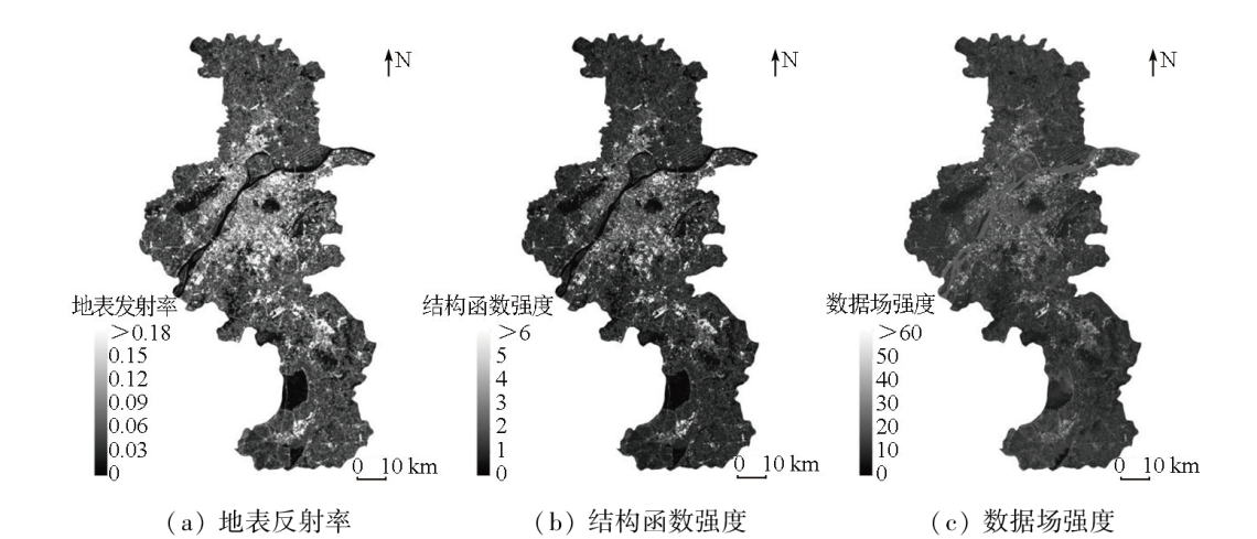
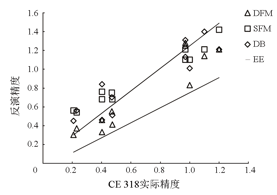
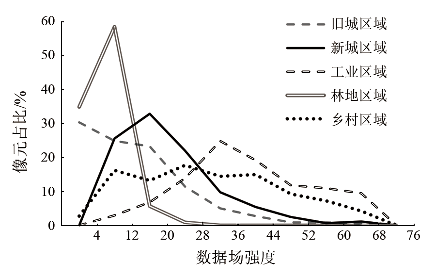
Abstract The inversion of aerosol optical depth (AOD) above the bright surface holds great significance for monitoring urban atmospheric environment and investigating urban pollution islands. This study proposed an AOD inversion method using the data field method (DFM) by incorporating both spectral and spatial characteristics of pixels. Using the Land OLI data, this study conducted AOD inversion over Nanjing and analyzed the impacts of different spatial structures, data field intensity, and underlying surface features on the DFM. This method was then compared with the traditional Deep Blue algorithm and MOD04 products through a detailed comparative analysis. The results indicate that the DFM inversion results had a correlation coefficient of 0.936 with observations obtained using aCE318 sun photometer, a root mean square error of 0.151, a mean absolute error of 0.120, an average relative error of 22.7%, a relative mean deviation of 1.139, and an error ratio of 72.7%, demonstrating high consistency with ground-based measurements. In areas with surface data field intensity exceeding 12, the DFM algorithm exhibited superior inversion performance and proved more effective in the spring and summer than in autumn and winter. Particularly, this algorithm achieved enhanced inversion results in rural and industrial areas characterized by rapid changes in their underlying surfaces.
|
| Keywords
aerosol optical depth
data field method
6S model
structure function method
|
|
|
|
Issue Date: 23 December 2024
|
|
|
| [1] |
Boiyo R, Kumar K R, Zhao T L. Spatial variations and trends in AOD climatology over East Africa during 2002-2016:A comparative study using three satellite data sets[J]. International Journal of Climatology, 2018, 38:e1221-e1240.
|
| [2] |
丁莹, 冯徽徽, 邹滨, 等. 长株潭城市群气溶胶时空分布与传输规律[J]. 中国环境科学, 2020, 40(5):1906-1914.
|
| [2] |
Ding Y, Feng H H, Zou B, et al. Spatial-temporal distribution and transport characteristic of aerosol in Changsha-Zhuzhou-Xiangtan urban agglomeration[J]. China Environmental Science, 2020, 40(5):1906-1914.
|
| [3] |
Li W, Shao L. Transmission electron microscopy study of aerosol particles from the brown hazes in Northern China[J]. Journal of Geophysical Research:Atmospheres, 2009, 114(D9):D09302.
|
| [4] |
Kaufman Y J, Sendra C. Algorithm for automatic atmospheric corrections to visible and near-IR satellite imagery[J]. International Journal of Remote Sensing, 1988, 9(8):1357-1381.
|
| [5] |
Hsu N C, Jeong M J, Bettenhausen C, et al. Enhanced deep blue aerosol retrieral algorithm: The second generation[J]. Journal of Geo physical Resrarch:Atmospheres, 2013, 118(16):9296-9315.
|
| [6] |
赵金涛. 基于Landsat-8 OLI影像的气溶胶光学厚度反演研究[D]. 银川: 宁夏大学, 2021.
|
| [6] |
Zhao J T. Research on the inversion of aerosol optical thickness based on Landsat-8 OLI image[D]. Yinchuan: Ningxia University, 2021.
|
| [7] |
朱琳, 孙林, 杨磊, 等. 结构函数法反演气溶胶光学厚度中像元的间隔设置[J]. 遥感学报, 2016, 20(4):528-539.
|
| [7] |
Zhu L, Sun L, Yang L, et al. Pixel distance settings in aerosol optical depth retrieval through the structure function method[J]. Journal of Remote Sensing, 2016, 20(4):528-539.
|
| [8] |
Liu G R, Chen A J, Lin T H, et al. Applying SPOT data to estimate the aerosol optical depth and air quality[J]. Environmental Modelling and Software, 2002, 17(1):3-9.
|
| [9] |
Zhou G, Zhang Y, Ma Z, et al. A geostatistics-based method to determine the pixel distance in a structure function model for aerosol optical depth inversion[J]. Atmosphere, 2017, 8(1):6.
|
| [10] |
Xia Z L, Li H, Chen Y H, et al. Identify and delimitate urban hotspot areas using a network-based spatiotemporal field clustering method[J]. ISPRS International Journal of Geo-Information, 2019, 8(8):344.
|
| [11] |
冯霞. 基于变异函数和数据场的高分遥感影像空间结构特征描述[D]. 武汉: 武汉大学, 2014.
|
| [11] |
Feng X. Spatial structural feature description for high resolution remote sensing images based on variogram and data field[D]. Wuhan: Wuhan University, 2014.
|
| [12] |
刘楠. 基于光谱空间数据场模型的遥感影像边缘提取[D]. 武汉: 武汉大学, 2005.
|
| [12] |
Liu N. Edge detection of remote sensing image based on data field model in spectral space[D]. Wuhan: Wuhan University, 2005.
|
| [13] |
Wang S, Wang D, Li C, et al. Clustering by fast search and find of density peaks with data field[J]. Chinese Journal of Electronics, 2016, 25(3):397-402.
|
| [14] |
Tao S Y. A review of recent research on the East Asian summer monsoon in China[J]. Monsoon Meteorology, 1987:60-92.
|
| [15] |
《中国城市统计年鉴—2018》编委会与编辑部. 陈小龙总编,中国城市统计年鉴,中国统计出版社, 2018,4-5.
|
| [15] |
Editorial Board and Editorial Department of China Urban Statistical Yearbook-2018. Chen Xiaolong as Editor-in-Chief,China Urban Statistical Yearbook published by China Statistics Press, 2018,4-5.
|
| [16] |
Gerace A, Montanaro M. Derivation and validation of the stray light correction algorithm for the thermal infrared sensor onboard Landsat8[J]. Remote Sensing of Environment, 2017, 191:246-257.
|
| [17] |
Smirnov A, Holben B N, Eck T F, et al. Cloud-screening and quality control algorithms for the AERONET database[J]. Remote Sensing of Environment, 2000, 73(3):337-349.
|
| [18] |
朱佳恒. 复杂地形与下垫面条件下的ERA5再分析地表温度降尺度研究[D]. 南京: 南京信息工程大学, 2022.
|
| [18] |
Zhu J H. Reanalysis of ERA5 under complex terrain and underlying surface conditions; Downscaling of surface temperature[D]. Nanjing: Nanjing University of Information Science and Technology, 2022.
|
| [19] |
陶建斌, 舒宁, 沈照庆. 基于数据场聚类的遥感影像分类方法研究[J]. 国土资源遥感, 2008, 20(3):20-23,26.doi:10.6046/gtzyyg.2008.03.05.
|
| [19] |
Tao J B, Shu N, Shen Z Q. A study of the method for clssification of remote sensing images based on data field cluster[J]. Remote Sensing for Land & Resources, 2008, 20(3):20-23,26.doi:10.6046/gtzyyg.2008.03.05.
|
| [20] |
徐涵秋. 利用改进的归一化差异水体指数(MNDWI)提取水体信息的研究[J]. 遥感学报, 2005, 9(5):589-595.
|
| [20] |
Xu H Q. A study on information extraction of water body with the modified normalized difference water index (MNDWI)[J]. Journal of Remote Sensing, 2005, 9(5):589-595.
|
| [21] |
李兆麟, 左洪超, 罗雯. 利用6S模型的自定义气溶胶类型反演北京地区气溶胶光学厚度[J]. 甘肃科技, 2019, 35(6):33-39.
|
| [21] |
Li Z L, Zuo H C, Luo W. Aerosol optical depth retrieval with a custom aerosol type using 6S models over Beijing area[J]. Gansu Science and Technology, 2019, 35(6):33-39.
|
| [22] |
程晨, 陈健, 李鑫慧. 基于TM图像的南京市气溶胶光学厚度反演[J]. 国土资源遥感, 2013, 25(3):90-96.doi:10.6046/gtzyyg.2013.03.16.
|
| [22] |
Cheng C, Chen J, Li X H. Retrieving aerosol optical depth over Nanjing City based on TM image[J]. Remote Sensing for Land and Resources, 2013, 25(3):90-96.doi:10.6046/gtzyyg.2013.03.16.
|
| [23] |
Layeb A. Novel feature selection algorithms based on crowding distance and Pearson correlation coefficient[J]. International Journal of Intelligent Systems and Applications, 2023, 15(2):37-42.
|
| [24] |
Hsu N C, Tsay S C, King M D, et al. Aerosol properties over bright-reflecting source regions[J]. IEEE Transactions on Geoscience and Remote Sensing, 2004, 42(3):557-569.
|
| [25] |
田信鹏, 孙林, 刘强, 等. 北京地区Landsat8 OLI高空间分辨率气溶胶光学厚度反演[J]. 遥感学报, 2018, 22(1):51-63.
|
| [25] |
Tian X P, Sun L, Liu Q, et al. Retrieval of high-resolution aerosol optical depth using Landsat8 OLI data over Beijing[J]. Journal of Remote Sensing, 2018, 22(1):51-63.
|
|
Viewed |
|
|
|
Full text
|
|
|
|
|
Abstract
|
|
|
|
|
Cited |
|
|
|
|
| |
Shared |
|
|
|
|
| |
Discussed |
|
|
|
|
 2024,
Vol. 36
2024,
Vol. 36
 ), CHEN Jian(