|
|
|
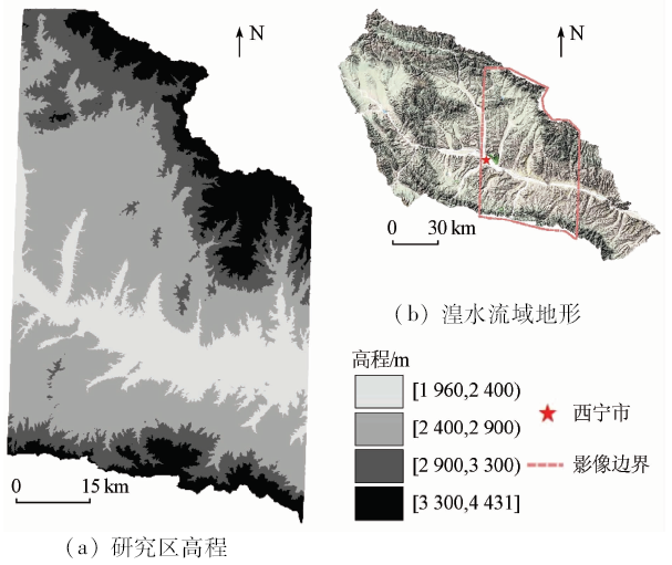
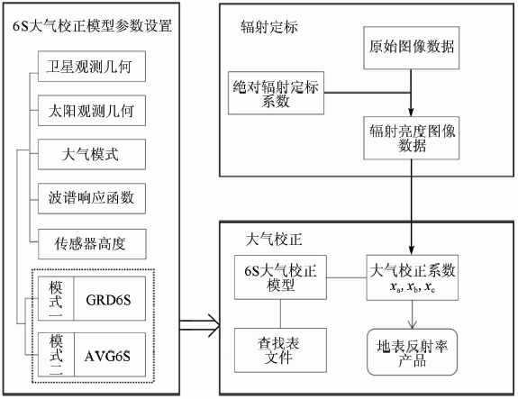
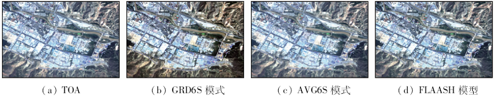
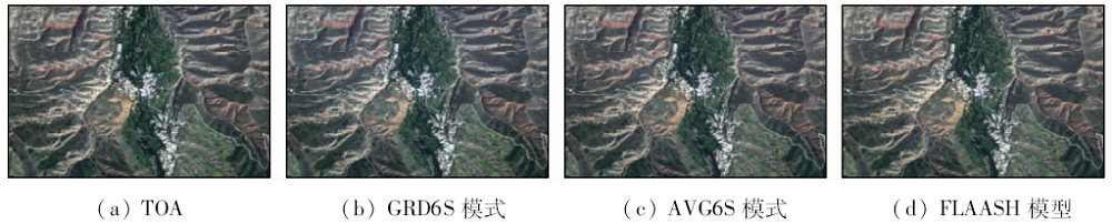
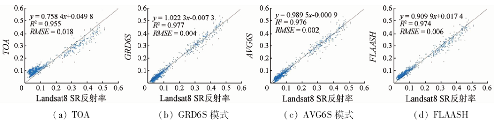
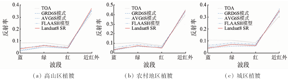
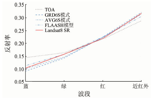
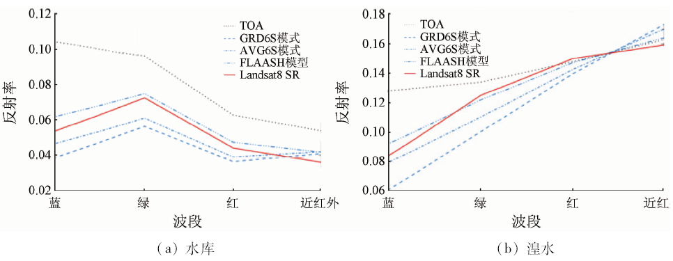
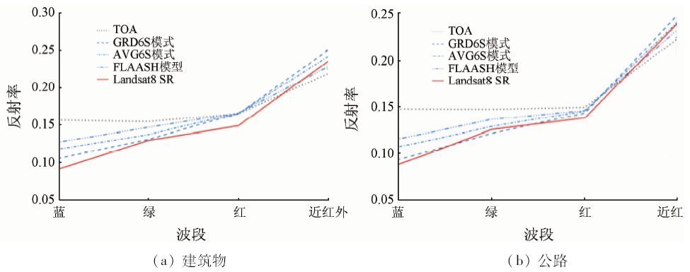
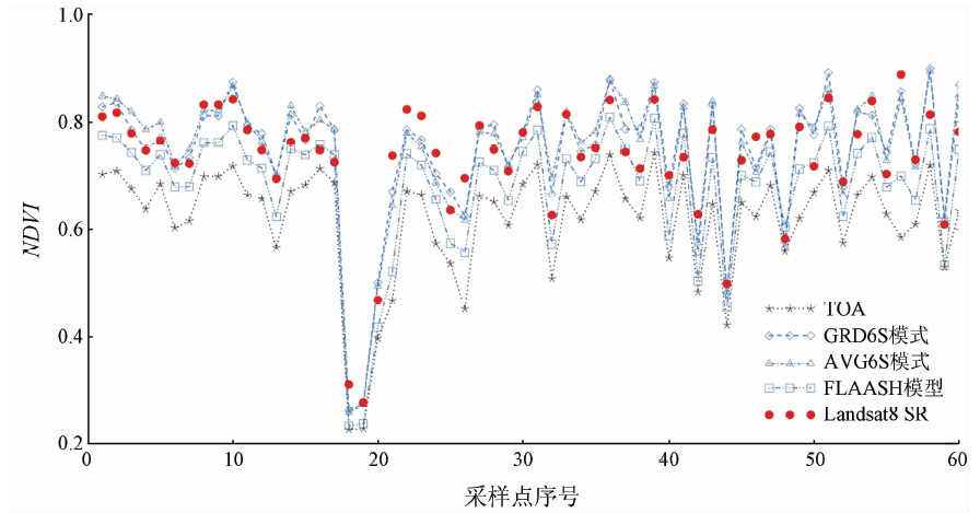
Abstract In order to obtain the best atmospheric correction method for real surface reflectance of SPOT6 images in high-altitude complex terrain areas with less research, the authors used the 6S model and FLAASH model to perform atmospheric correction for the SPOT6 image covering Huangshui River basin in eastern Tibet Plateau. For the 6S model, the images were processed by AVG6S and GRD6S according to the average aerosol optical depth (AOD), altitude parameters and gradient AOD as well as altitude parameters. The calibration results were verified with the Landsat8 SR surface reflectance product. The results show that the image quality is significantly improved after atmospheric correction, and the reflection characteristics of various ground objects are more realistically reflected. Correlation analysis and a comparison with typical ground reflection spectrum curve and normalized difference vegetation index (NDVI) show that the overall performance of AVG6S is the best, whereas GRD6S performance is more prominent in urban and high mountain areas. The calibration result of the 6S model is better than that of the FLAASH model and hence the 6S model is an atmospheric correction method more suitable for high altitude region.
|
| Keywords
atmospheric correction
SPOT6 image
6S model
FLAASH model
Huangshui River basin
|
|
|
|
Corresponding Authors:
Xiaohong GAO
E-mail: xiaohonggao226@163.com
|
|
Issue Date: 14 March 2020
|
|
|
| [1] |
徐言, 姜琦刚 . 基于6S模型的MODIS影像逐像元大气校正及其应用[J]. 吉林大学学报(地理科学版), 2015,45(5):1547-1553.
|
| [1] |
Xu Y, Jiang Q G . A pixel by pixel atmospheric correction algorithm and its application for MODIS data based on 6S model[J]. Journal of Jilin University(Earth Science Edition), 2015,45(5):1547-1553.
|
| [2] |
杜鑫, 陈雪洋, 蒙继华 , 等. 基于6S模型的环境星CCD数据大气校正[J]. 国土资源遥感, 2010,22(2):22-25.doi: 10.6046/gtzyyg.2010.02.05.
|
| [2] |
Du X, Chen X Y, Meng J H , et al. Atmospheric correction of HJ-1 CCD data based on 6S Model[J]. Remote Sensing for Land and Resource, 2010,22(2):22-25.doi: 10.6046/gtzyyg.2010.02.05.
|
| [3] |
陈静, 姚静 . Landsat-5 TM影像增益偏置值对地面反射率计算影响分析[J]. 国土资源遥感, 2010,22(2):45-54.doi: 10.6046/gtzyyg.2010.02.10.
|
| [3] |
Chen J, Yao J . The analysis of impaction in calculating surface reflectance of Landsat-5 TM caused by Gain and Bias values[J]. Remote Sensing for Land and Resource, 2010,22(2):45-54.doi: 10.6046/gtzyyg.2010.02.10.
|
| [4] |
苏伟, 张明政, 蒋坤萍 , 等. Sentinel-2卫星影像的大气校正方法[J]. 光学学报, 2018, 38(1):0128001-1-0128001-10.
|
| [4] |
Su W, Zhang M Z, Jiang K P , et al. Atmospheric correction method for Sentinel-2 satellite imagery[J]. Acta Optica Sinica, 2018, 38(1):0128001-1-0128001-10.
|
| [5] |
Yu X, Yan Q, Liu Z . Atmospheric correction of HJ-1A multi-spectral and hyper-spectral images[C]// International Congress on Image & Signal Processing.IEEE, 2010: 2125-2129.
|
| [6] |
Vermote E F, Tanre D, Deuze J L , et al. The second simulation of the satellite signal in the solar spectrum(6S)User’s Guide[Z]. France:Laboratoire d’ Optique Atmospherique, 1997.
|
| [7] |
马世斌, 杨文芳, 张焜 . SPOT6卫星图像处理关键技术研究[J]. 国土资源遥感, 2015,27(3):30-35.doi: 10.6046/gyzyyg.2015.03.06.
|
| [7] |
Ma S B, Yang W F, Zhang K . Study of key technology of SPOT6 satellite image processing[J]. Remote Sensing for Land and Resource, 2015,27(3):30-35.doi: 10.6046/gyzyyg.2015.03.06.
|
| [8] |
赵越, 曾群, 陈晓玲 . HJ-1A/1B卫星CCD影像的鄱阳湖6S大气校正研究[J]. 华中师范大学学(自然科学版), 2012,46(6):751-761.
|
| [8] |
Zhao Y, Zeng Q, Chen X L , et al. A study on the 6S model of atmospheric correction method for the HJ-1A/1B CCD image of Poyang Lake[J]. Journal of Huazhong Normal University(Natural Sciences), 2012,46(6):757-761.
|
| [9] |
Department of the Interior U.S. Geological Survey.Product Guide-Landsat8 Surface Reflectance Code (LASRC) Product[Z]. 2018.
|
| [10] |
Xue X, Meng O, Xie Y , et al. Case study of atmospheric correction on CCD data of HJ-1 satellite based on 6S model[C]// IOP Conference Series:Earth and Environmental Science, 2014,17:012215.
|
| [11] |
Wang Z, Xia J S, Wang L H , et al. Atmospheric correction methods for GF-1 WFV1 data in hazy weather[J]. Journal of the Indian Society and Remote Sensing, 2018,46(3):355-366.
|
| [12] |
Nguyen H C, Jung J, Lee J , et al. Optimal atmospheric correction for above-ground forest biomass estimation with the ETM+ remote sensor[J]. Sensors, 2015,15:18865-18886.
|
| [13] |
Zhao W J, Tamura M, Takahashi H . Atmospheric and spectral corrections for estimating surface albedo from satellite data using 6S code[J]. Remote Sensing of Environment, 2000,76:202-212.
|
| [14] |
沈强 . 基于辐射传输模型的遥感影像大气纠正[D]. 武汉:武汉大学, 2005.
|
| [14] |
Shen Q . Atmospheric of Corrections Remote Sensing Images Based on the Radiative Transfer Model[D]. Wuhan:Wuhan University, 2005.
|
| [15] |
Richter R . Correction of atmospheric and topographic effects for high spatial resolution satellite imagery[J]. International Journal of Remote Sensing, 1997,18(5):1099-1111.
|
| [16] |
杨静学, 王云鹏, 杨勇 . 基于高程或气溶胶厚度与6S模型校正参数回归方程的遥感图像大气校正模型[J]. 遥感技术与应用, 2009,24(3):331-339.
|
| [16] |
Yang J X, Wang Y P, Yang Y . Remote sensing image atmospheric correction model based on elevation or aerosol thickness and 6S model corrected parameter regression equation[J]. Remote Sensing Technology and Application, 2009,24(3):331-339.
|
| [17] |
Richter R, Daniel S, Andreas M . An automatic atmospheric correction algorithm for visible/NIR imagery[J]. International Journal of Remote Sensing, 2006,27(10):2077-2085.
|
| [18] |
穆悦, 安裕伦, 王喆 , 等. 不同地形校正模型计算地形复杂山区地表反射率的对比[J]. 山地学报, 2014,32(3):257-266.
|
| [18] |
Mu Y, An Y L, Wang Z , et al. Comparison of different topographic correction models for surface reflectance calculating in rugged terrain area[J]. Mountain Research, 2014. 32(3):257-266.
|
| [19] |
徐永明 . 遥感二次开发语言IDL[M]. 北京: 科学出版社, 2014.
|
| [19] |
Xu Y M. Remote Sensing of Secondary Development Language IDL[M]. BeiJing: Science Press, 2014.
|
| [20] |
董彦卿 . IDL程序设计—数据可视化与ENVI二次开发[M]. 北京: 高等教育出版社, 2012.
|
| [20] |
Dong Y Q. IDL Programming:Data Visualization and ENVI Secondary Development[M]. Beijing: High Education Press, 2012.
|
| [21] |
赵英时 . 遥感应用分析原理与方法[M]. 北京: 科学出版社, 2003: 20-34.
|
| [21] |
Zhao Y S. The Principle and Method of Remote Sending Application Analysis[M]. Beijing: Science Press, 2003: 20-34.
|
| [22] |
梅安新, 彭望琭, 秦其明 , 等. 遥感导论[M]. 北京: 高等教育出版社, 2001: 56-80.
|
| [22] |
Mei A X, Peng W L, Qin Q M , et al. Introduction to Remote Sensing[M]. Beijing: High Education Press, 2001: 56-80.
|
| [23] |
姚薇, 李志军, 姚珙 , 等. Landsat卫星遥感影像的大气校正方法研究[J]. 大气科学学报, 2011,34(2):251-256.
|
| [23] |
Yao W, Li Z J, Yao G , et al. Atmospheric correction model for Landsat images[J]. Transactions of Atmospheric Sciences, 2011,34(2):251-256.
|
| [24] |
甘文霞, 沈焕锋, 张良培 , 等. 采用6S模型的多时相MODIS植被指数NDVI归一化方法[J]. 武汉大学学报(信息科学版), 2014,39(3):300-304.
|
| [24] |
Gan W X, Shen H F, Zhang L P , et al. Multi-temporal MODIS vegetation index NDVI normalization method using 6S model[J]. Geomatics and Information Scienc of Wuhan Univeristy, 2014,39(3):300-304.
|
|
Viewed |
|
|
|
Full text
|
|
|
|
|
Abstract
|
|
|
|
|
Cited |
|
|
|
|
| |
Shared |
|
|
|
|
| |
Discussed |
|
|
|
|
 2020,
Vol. 32
2020,
Vol. 32
 ), Min TANG