|
|
|

|
|
|
Progress in the information-based construction of marine geology |
SUN Jihong1( ), WEI Helong1, SU Guohui1(), CHEN Hongwen2, LIU Jingpeng1, LIN Wenrong1, WANG Zhao1, ZHANG Zhaodai1 ), WEI Helong1, SU Guohui1(), CHEN Hongwen2, LIU Jingpeng1, LIN Wenrong1, WANG Zhao1, ZHANG Zhaodai1 |
1. Qingdao Institute of Marine Geology, Qingdao 266701, China
2. Guangzhou Marine Geological Survey, Guangzhou 510760, China |
|
|
|
|
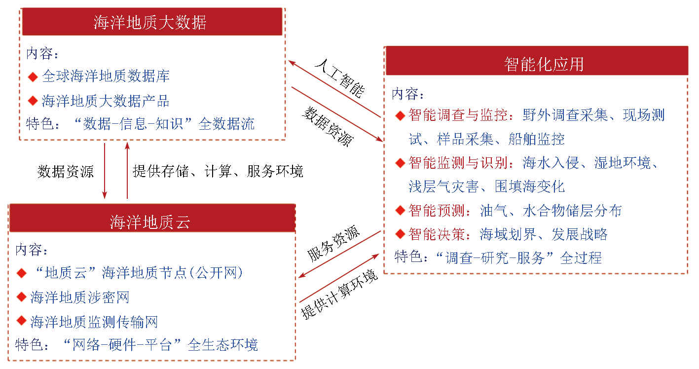
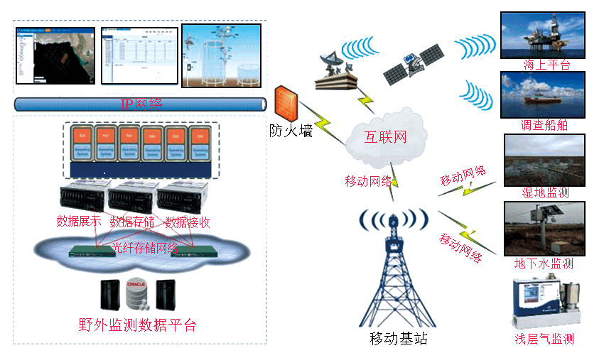
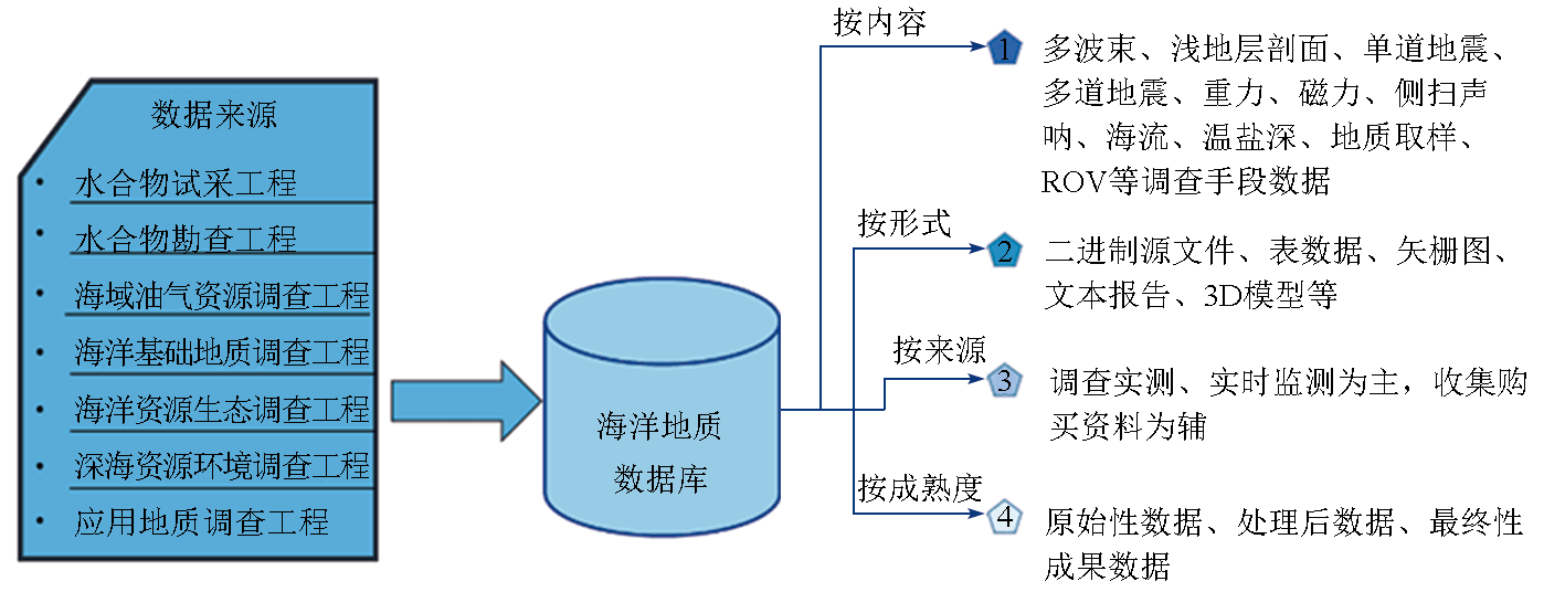
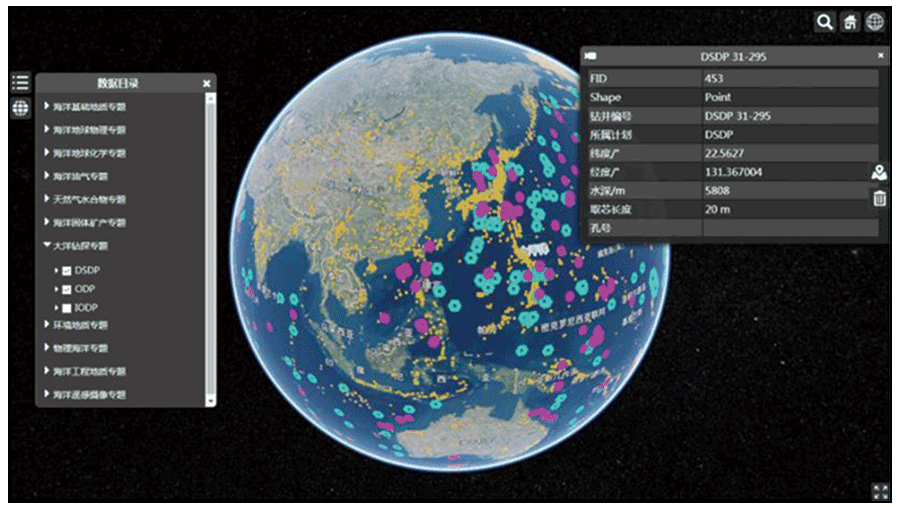
Abstract As marine geological surveys continue to deepen, there is an urgent need to develop new-generation information technologies to accelerate the transformation of marine geological survey pattern. In recent years, the digital marine geological project has developed a comprehensive framework of trinity that integrates geological cloud, big data, and intellectualization based on the practical needs of marine geological surveys. Furthermore, the planning of three major systems, i.e., the support, core, and key systems, has been proposed for marine geological informatization. These suggest significant progress in the construction of marine geological cloud platform, marine geological big data infrastructure, and intelligent applications in marine geology. The progress also includes the building of professional marine geological nodes and network systems, the formation of a national marine geological data resource system, and the advancement in the intelligent application of marine geological operations. Information-based construction have played a full role in promoting the transformation and upgrading of geological surveys, while also serving natural resources management.
|
| Keywords
marine geology
informatization
big data
intelligence
|
|
|
|
Issue Date: 17 February 2025
|
|
|
| [1] |
魏合龙, 孙记红, 苏国辉, 等. 数字海洋地质工程建设进展[J]. 海洋地质前沿, 2018, 34(3): 1-7.
|
| [1] |
Wei H L, Sun J H, Su G H, et al. Construction progress of digital marine geological project[J]. Marine Geology Frontiers, 2018, 34(3): 1-7.
|
| [2] |
青岛海洋地质研究所. 数字海洋地质工程2021年度进展报告[R]. 青岛: 青岛海洋地质研究所, 2021.
|
| [2] |
Qingdao Institute of Marine Geology. Progress report of digital marine geology(2021)[R]. Qingdao: Qingdao Institute of Marine Geology, 2021.
|
| [3] |
戴勤奋, 魏合龙, 苏国辉, 等. 海洋地质大数据信息服务体系建设[J]. 海洋地质前沿, 2017, 33(11): 67-70.
|
| [3] |
Dai Q F, Wei H L, Su G H, et al. Construction of informatization service system for marine geological big data[J]. Marine Geology Frontiers, 2017, 33(11): 67-70.
|
| [4] |
李超岭, 李丰丹, 李健强, 等. 智能地质调查体系与架构[J]. 中国地质, 2015, 42(4): 828-838.
|
| [4] |
Li C L, Li F D, Li J Q, et al. Smart geological survey architecture[J]. Geology in China, 2015, 42(4): 828-838.
|
| [5] |
孙记红, 苏国辉, 林峰, 等. 海洋地质信息服务系统建设[J]. 中国地质调查成果快讯, 2019, 5(1): 18-22.
|
| [5] |
Sun J H, Su G H, Lin F, et al. Construction of marine geological information service system[J]. China Geological Survey Results News, 2019, 5(1): 18-22.
|
| [6] |
戴勤奋. 海洋地质数据库内容与结构[R]. 北京: 中国地质调查局, 2021.
|
| [6] |
Dai Q F. Content and structure of marine geological database[R]. Beijing: China geology survey, 2021.
|
| [7] |
Sun J H, Wei H L. Construction method of marine geological data service platform based on object-oriented approach[J]. ICIC Express Letters,Part B: Applications, 2015, 6(8): 2047-2052.
|
| [8] |
孙记红, 何书锋, 魏合龙, 等. 海洋地质数据库应用模型构建方法[J]. 计算机技术与发展, 2013, 23(12): 194-198.
|
| [8] |
Sun J H, He S F, Wei H L, et al. Structure method of marine geological database application model[J]. Computer Technology and Development, 2013, 23(12): 194-198.
|
| [9] |
宋怀荣, 林峰, 苏国辉, 等. 海洋地质调查数据库数据录入方法[J]. 海洋地质前沿, 2016, 32(2): 66-70.
|
| [9] |
Song H R, Lin F, Su G H, et al. Improvement of data entry system for marine geological survey database[J]. Marine Geology Frontiers, 2016, 32(2): 66-70.
|
| [10] |
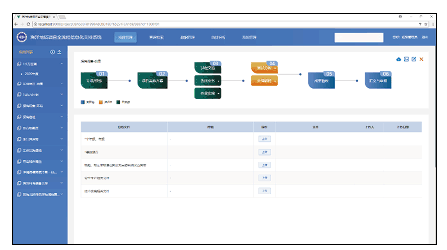
孙记红, 魏合龙, 林文荣, 等. 海洋地质调查全流程信息化支持系统的设计与实现[J]. 海洋地质前沿, 2023, 39(2): 49-55.
|
| [10] |
Sun J H, Wei H L, Lin W R, et al. Design and running of supporting system to the whole-process informatization of marine geological survey[J]. Marine Geology Frontiers, 2023, 39(2): 49-55.
|
| [11] |
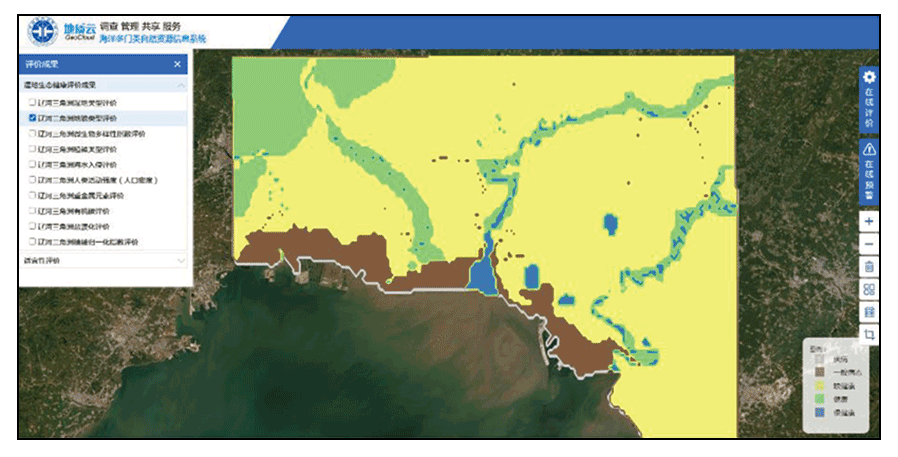
陈琦, 苏国辉, 魏合龙, 等. 江苏盐城滨海湿地净生态系统碳交换量模拟参数选择[J]. 海洋地质前沿, 2023, 39(2): 56-65.
|
| [11] |
Chen Q, Su G H, Wei H L, et al. Selection of parameters for simulation of net ecosystem carbon flux in Yancheng coastal wetland, Jiangsu[J]. Marine Geology Frontiers, 2023, 39(2): 56-65.
|
| [12] |
Sheng J, Sun J H, Bai Y L, et al. Evaluation of hydrocarbon potential using fuzzy AHP-based grey relational analysis:A case study in the Laoshan Uplift, South Yellow Sea, China[J]. Journal of Geophysics and Engineering, 2020, 17 (1): 189-202.
doi: 10.1093/jge/gxz107
|
| [13] |
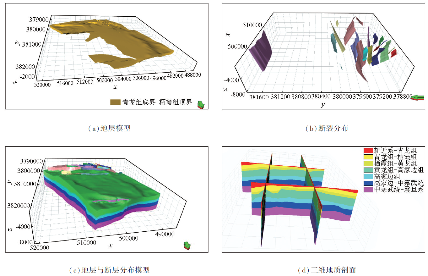
孙记红, 魏合龙, 王诏, 等. 基于Open Inventor的重点海域地质体三维模型构建[J]. 海洋地质前沿, 2018, 34(3): 39-45.
|
| [13] |
Sun J H, Wei H L, Wang Z, et al. 3D model construction of geological bodies in key marine areas based on Open Inventor[J]. Marine Geology Frontiers, 2018, 34(3): 39-45.
|
|
Viewed |
|
|
|
Full text
|
|
|
|
|
Abstract
|
|
|
|
|
Cited |
|
|
|
|
| |
Shared |
|
|
|
|
| |
Discussed |
|
|
|
|
 2025,
Vol. 37
2025,
Vol. 37