|
|
 |
|

|
|
|
Remote sensing-based monitoring and identification mechanisms of the spatiotemporal dynamics of Suaeda salsa in the Liaohe estuary, China |
LI Yubin1,2( ), WANG Zongming2, ZHAO Chuanpeng2(), JIA Mingming2, REN Chunying2, MAO Dehua2, YU Hao1 ), WANG Zongming2, ZHAO Chuanpeng2(), JIA Mingming2, REN Chunying2, MAO Dehua2, YU Hao1 |
1. School of Surveying, Mapping and Exploration Engineering, Jilin Jianzhu University, Changchun 130118, China
2. Key Laboratory of Wetland Ecology and Environment, Northeast Institute of Geography and Agroecology, Chinese Academy of Sciences, Changchun 130102, China |
|
|
|
|
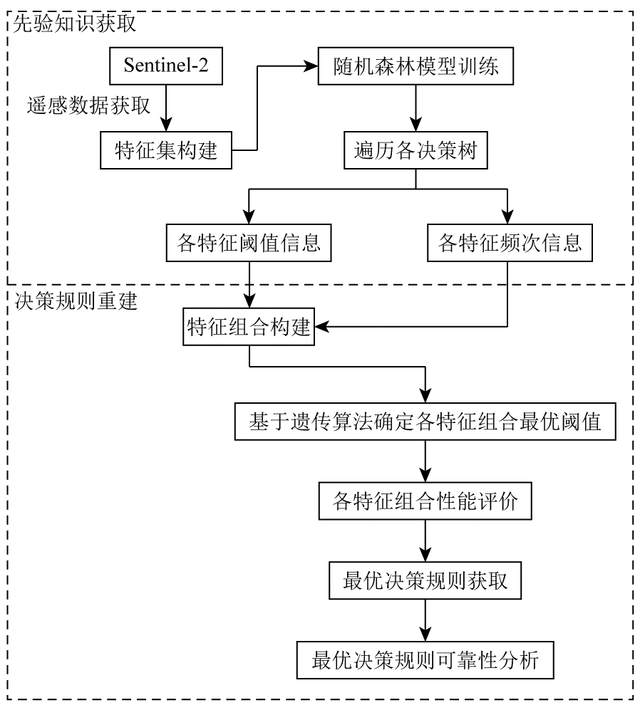
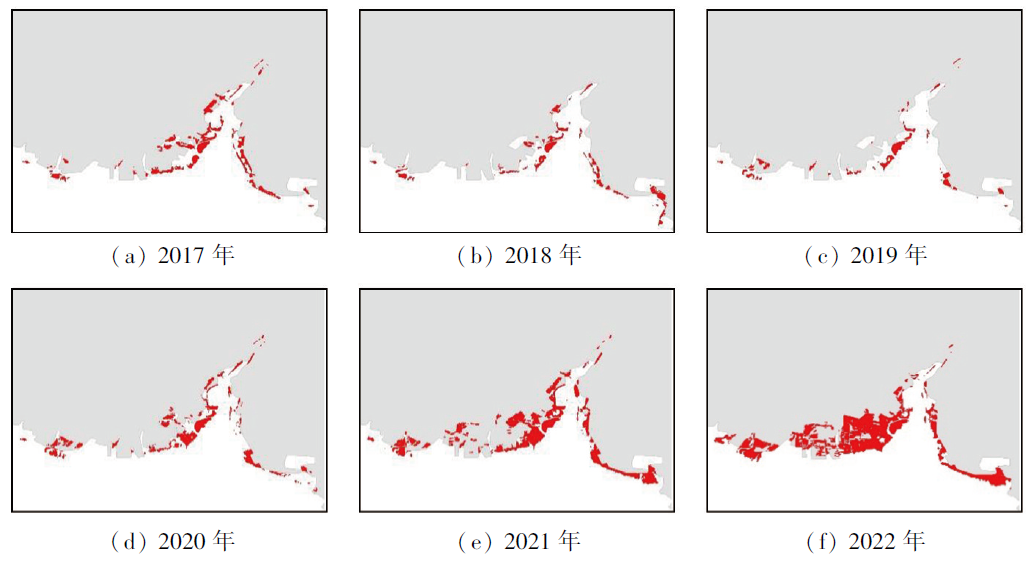
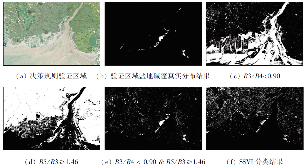
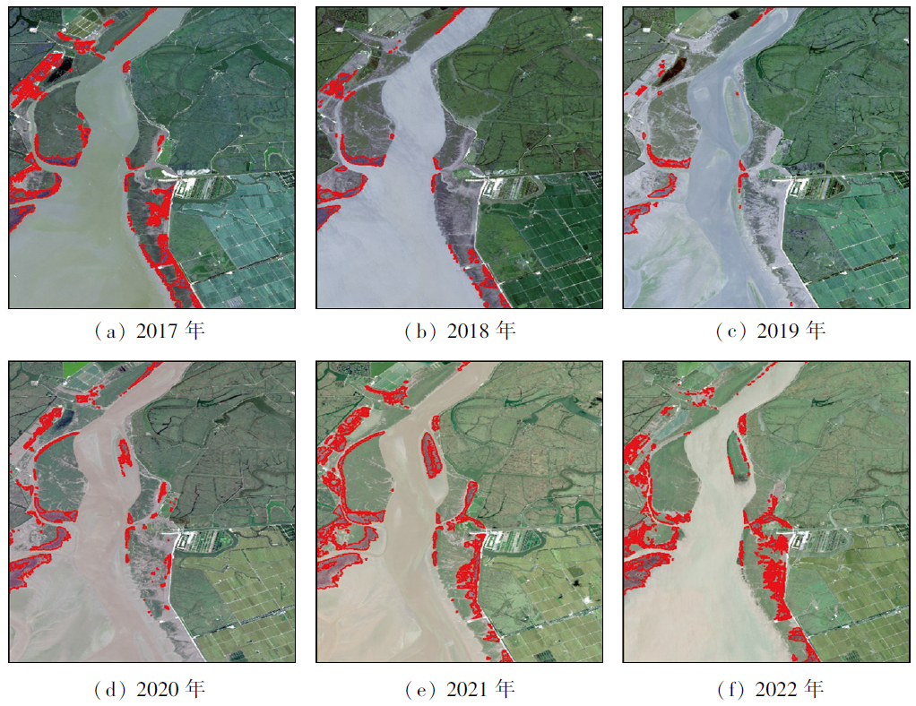
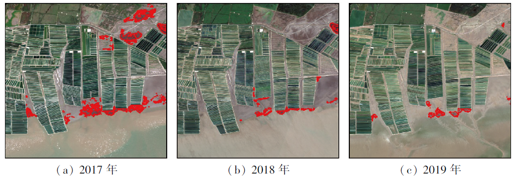
Abstract The Liaohe estuary of China boasts the largest red beach landscape in the world. Monitoring the spatiotemporal dynamics of Suaeda salsa in this region is of great significance for revealing the performance of conservation measures such as returning aquaculture to wetlands. Currently, satellite remote sensing technology has been widely applied to the mapping and identification of coastal vegetation including Suaeda salsa. However, existing classification methods rely on black-box models, which are difficult to interpret, while overlooking exploring identification mechanisms. This has hindered the improvement and development of related methods. Fortunately, the advancement in explainable artificial intelligence (XAI) has provided new directions for analyzing the black-box models. Considering that the decision rules in random forests are interpretable, this study developed a new method to extract the optimal decision rules from trained random forest models. Using this method, this study ultimately reconstructed the optimal decision rules used to identify Suaeda salsa, i.e., B3/B4<0.90 & B5/B3≥1.46, with an overall data accuracy exceeding 90%. Using annual Sentinel-2 images from 2017 to 2022 as a data source, the study successfully extracted the annual dynamics of Suaeda salsa in the Liaohe Estuary. Accordingly, by combining the centroid migration method, this study analyzed the spatiotemporal changes in the Suaeda salsa following the implementation of returning aquaculture to wetlands, revealing the current status that the Suaeda salsa in this region is undergoing rapid restoration.
|
| Keywords
returning aquaculture to wetlands
Suaeda salsa
explainable artificial intelligence (XAI)
random forests
decision rule
|
|
|
|
Issue Date: 17 February 2025
|
|
|
| [1] |
温广玥. 1997—2018年辽河口翅碱蓬生物群落时空变化特征研究[D]. 北京: 中国地质大学(北京), 2020.
|
| [1] |
Wen G Y. Temporal and spatial variation of Suaeda salsa community in Liaohe River from 1997 to 2018[D]. Beijing: China University of Geosciences, 2020.
|
| [2] |
Gu J, Jin R, Chen G, et al. Areal extent,species composition,and spatial distribution of coastal saltmarshes in China[J]. IEEE Journal of Selected Topics in Applied Earth Observations and Remote Sensing, 2021,14:7085-7094.
|
| [3] |
王旖旎, 康亚茹, 陈旭, 等. 辽河口潮滩湿地景观格局空间演变的动态分析[J]. 大连海洋大学学报, 2021, 36(6):1009-1017.
|
| [3] |
Wang Y N, Kang Y R, Chen X, et al. Dynamic analysis of spatial evolution of landscape pattern in the tidal flat wetlands at Liao River Estuary[J]. Journal of Dalian Ocean University, 2021, 36(6):1009-1017.
|
| [4] |
Cao C, Su F, Song F, et al. Distribution and disturbance dynamics of habitats suitable for Suaeda salsa[J]. Ecological Indicators, 2022,140:108984.
|
| [5] |
邵璐, 姜华. 辽宁碱蓬根际土壤真菌多样性的季节变化及其耐盐性[J]. 生态学报, 2016, 36(4):1050-1057.
|
| [5] |
Shao L, Jiang H. Effect of season and variation in salinity on the rhizosphere fungal diversity of Suaeda liaotungensis[J]. Acta Ecologica Sinica, 2016, 36(4):1050-1057.
|
| [6] |
余雪洋, 叶思源, Yuknis N, 等. 辽河三角洲翅碱蓬湿地不同植被覆盖度下的土壤对碳的扣留[J]. 中国地质, 2014, 41(2):648-657.
|
| [6] |
Yu X Y, Ye S Y, Yuknis N, et al. Carbon sequestration along vegetation coverage gradient in the Suaeda salsa marsh from the Liaohe Delta[J]. Geology in China, 2014, 41(2):648-657.
|
| [7] |
何爽, 张森, 田家, 等. 结合多模态数据的滨海湿地碱蓬叶面积指数无人机高光谱反演[J]. 遥感学报, 2023, 27(6):1441-1453.
|
| [7] |
He S, Zhang S, Tian J, et al. UAV hyperspectral inversion of Suaeda Salsa leaf area index in coastal wetlands combined with multimodal data[J]. National Remote Sensing Bulletin, 2023, 27(6):1441-1453.
|
| [8] |
张树文, 颜凤芹, 于灵雪, 等. 湿地遥感研究进展[J]. 地理科学, 2013, 33(11):1406-1412.
doi: 10.13249/j.cnki.sgs.2013.011.1406
|
| [8] |
Zhang S W, Yan F Q, Yu L X, et al. Application of remote sensing technology to wetland research[J]. Scientia Geographica Sinica, 2013, 33(11):1406-1412.
|
| [9] |
彭剑伟. 1986—2018年辽河口滨海湿地连续变化时空格局及驱动力分析[D]. 长沙: 中南林业科技大学, 2021.
|
| [9] |
Peng J W. Spatial-temporal pattern and driving forces of continuous change of coastal wetlands in Liaohe Estuary from 1986 to 2018[D]. Changsha: Central South University of Forestry and Technology, 2021.
|
| [10] |
Song Z, Sun Y, Chen P, et al. Assessing the ecosystem health of coastal wetland vegetation (Suaeda salsa) using the pressure state response model,a case of the Liao River Estuary in China[J]. International Journal of Environmental Research and Public Health, 2022, 19(1):546.
|
| [11] |
王文硕. 典型盐生植被群落演替退化遥感监测研究[D]. 大连: 大连海洋大学, 2022.
|
| [11] |
Wang W S. Remote sensing monitoring research on the succession and degradation of typical saline vegetation community[D]. Dalian: Dalian Ocean University, 2022.
|
| [12] |
许晨, 卢霞, 桑瑜, 等. 基于空谱融合与AlexNet算法的滨海湿地植被分类研究[J]. 海洋科学, 2023, 47(7):1-11.
|
| [12] |
Xu C, Lu X, Sang Y, et al. Vegetation classification combining spatial—spectral feature fusion based on remote sensing and AlexNet algorithm in a coastal wetland[J]. Marine Sciences, 2023, 47(7):1-11.
|
| [13] |
Vilone G, Longo L. Notions of explainability and evaluation approaches for explainable artificial intelligence[J]. Information Fusion, 2021,76:89-106.
|
| [14] |
Chander A, Srinivasan R.Evaluating explanations by cognitive value[J].Proceedings of the Machine Learning and Knowledge Extraction:Second IFIP TC 5,TC 8/WG 84,89,TC 12/WG 129 International Cross-Domain Conference,CD-MAKE 2018,Hamburg,Germany,August 27-30,2018,Proceedings 2,F,2018 [C].Springer.
|
| [15] |
Tintarev N, Masthoff J. Explaining recommendations:Design and evaluation[M]// RicciF, RokachL, ShapiraB,eds.Recommender Systems Handbook. Boston, MA: Springer US,2015:353-382.
|
| [16] |
李营, 陈云浩, 陈辉, 等. GF-1 WFV影像的翅碱蓬植被指数构建[J]. 武汉大学学报(信息科学版), 2019, 44(12):1823-1831.
|
| [16] |
Li Y, Chen Y H, Chen H, et al. Construction of Suaeda salsa vegetation index based on GF-1 WFV images[J]. Geomatics and Information Science of Wuhan University, 2019, 44(12):1823-1831.
|
| [17] |
Rodriguez-Galiano V F, Ghimire B, Rogan J, et al. An assessment of the effectiveness of a random forest classifier for land-cover classification[J]. ISPRS Journal of Photogrammetry and Remote Sensing, 2012,67:93-104.
|
| [18] |
Zhao C, Jia M, Wang Z, et al. Toward a better understanding of coastal salt marsh mapping:A case from China using dual-temporal images[J]. Remote Sensing of Environment, 2023,295:113664.
|
| [19] |
Boruah A N, Biswas S K, Bandyopadhyay S. Transparent rule generator random forest (TRG-RF):An interpretable random forest[J]. Evolving Systems, 2023, 14(1):69-83.
|
| [20] |
Hou W, Zhang R, Xi Y, et al. The role of waterlogging stress on the distribution of salt marsh plants in the Liao River Estuary wetland[J]. Global Ecology and Conservation, 2020,23:e01100.
|
| [21] |
Zhao C, Jia M, Wang Z, et al. Toward a better understanding of coastal salt marsh mapping:A case from China using dual-temporal images[J]. Remote Sensing of Environment, 2023,295:113664.
|
| [22] |
程丽娜, 钟才荣, 李晓燕, 等. Sentinel-2密集时间序列数据和Google Earth Engine的潮间带湿地快速自动分类[J]. 遥感学报, 2022, 26(2):348-357.
|
| [22] |
Cheng L N, Zhong C R, Li X Y, et al. Rapid and automatic classification of intertidal wetlands based on intensive time series Sentinel-2 images and Google Earth Engine[J]. National Remote Sensing Bulletin, 2022, 26(2):348-357.
|
| [23] |
Maheshwari D, Garcia-Zapirain B, Sierra-Soso D. Machine learning applied to diabetes dataset using Quantum versus Classical computation[C]//2020 IEEE International Symposium on Signal Processing and Information Technology (ISSPIT). December 9-11,2020, Louisville,KY,USA.IEEE,2020:1-6.
|
| [24] |
张猛, 曾永年. 长株潭城市群湿地景观时空动态变化及驱动力分析[J]. 农业工程学报, 2018, 34(1):241-249.
|
| [24] |
Zhang M, Zeng Y N. Temporal and spatial dynamic changes and driving forces analysis of wetland landscape of Chang-Zhu-Tan urban agglomeration[J]. Transactions of the Chinese Society of Agricultural Engineering, 2018, 34(1):241-249.
|
| [25] |
黄子强. 鸻鹬类迁徙停歇期对翅碱蓬和潮间带湿地的栖息地利用[D]. 沈阳: 辽宁大学, 2019.
|
| [25] |
Huang Z Q. The habitate use of migrant shorebirds in Suaeda salsa salt marshes and the intertidal flats in Liaohe River delta[D]. Shenyang: Liaoning University, 2019.
|
| [26] |
Kan Z, Chen B, Yu W, et al. Forecasting land-cover change effects on waterbirds in Xiamen Bay,China:Determining prospective species winners and losers[J]. Marine Environmental Research, 2023,188:106003.
|
|
Viewed |
|
|
|
Full text
|
|
|
|
|
Abstract
|
|
|
|
|
Cited |
|
|
|
|
| |
Shared |
|
|
|
|
| |
Discussed |
|
|
|
|
 2025,
Vol. 37
2025,
Vol. 37