|
|
 |
|

|
|
|
Remote sensing monitoring and spatiotemporal variation analysis of vegetation cover under coal mining activities in the Shendong mining area from 1986 to 2023 |
WANG Yi1( ), ZHANG Yicong2, CHENG Yang1, XU Lianhang1, GUO Junting3, WANG Hui2, LI Jun2(), DU Shouhang2 ), ZHANG Yicong2, CHENG Yang1, XU Lianhang1, GUO Junting3, WANG Hui2, LI Jun2(), DU Shouhang2 |
1. China Energy Shendong Coal Group Co., Ltd., Yulin 719315, China
2. College of Geoscience and Surveying Engineering, China University of Mining and Technology - Beijing, Beijing 100083, China
3. State Key Laboratory of Water Resources Protection and Utilization in Coal Mining, Beijing 100011, China |
|
|
|
|
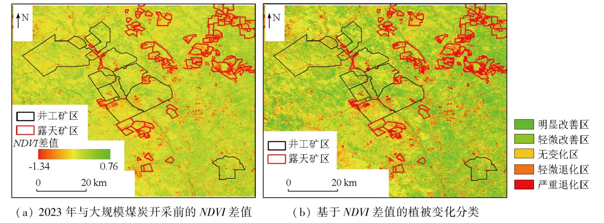
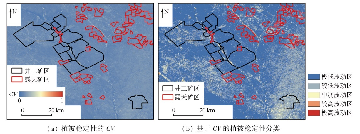
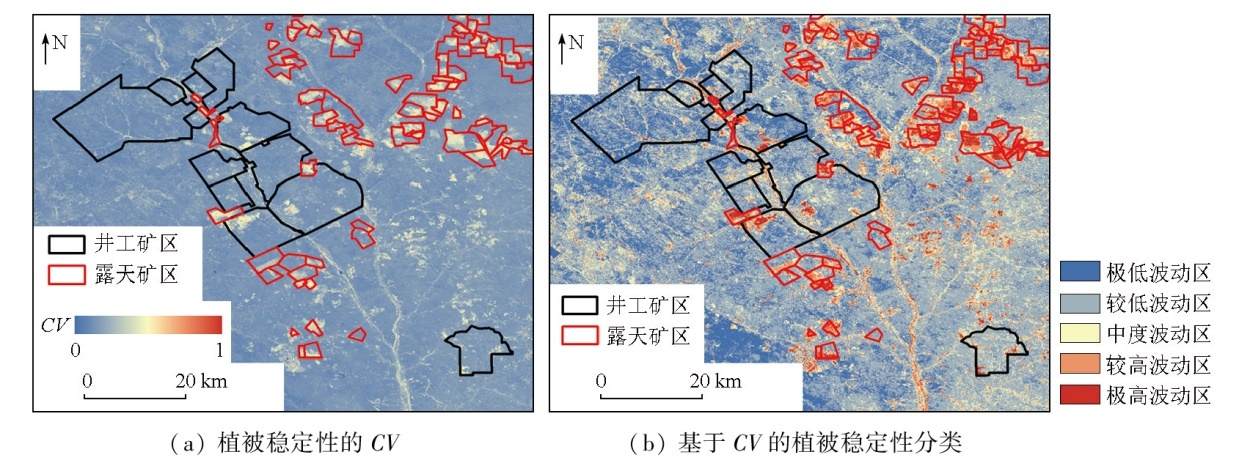
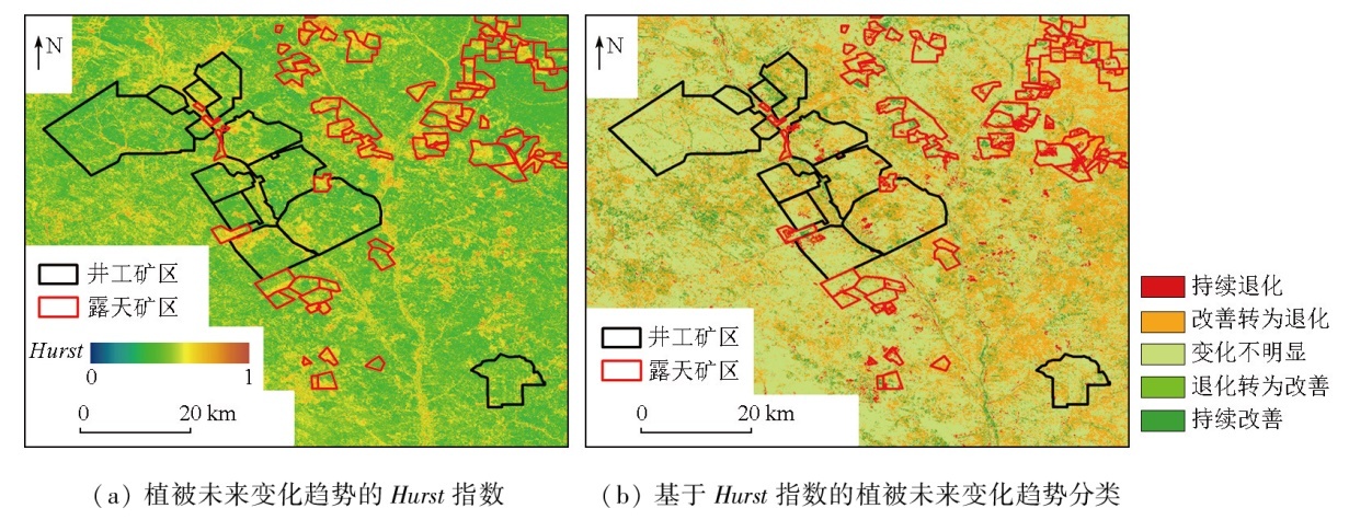
Abstract The Shendong mining area is a significant coal-producing area in China. Against the backdrop of climatic amelioration and large-scale coal mining, vegetation in the Shendong mining area has been influenced negatively by coal mining and positively by climatic amelioration and ecological restoration. Long time-series quantitative monitoring and assessment of vegetation cover in the mining area using remote sensing techniques play a significant role in local ecological quality management and ecological conservation. Based on Landsat satellite imagery data, this study conducted a long time-series monitoring of the normalized difference vegetation index (NDVI) in the Shendong mining area over a nearly 40-year period from 1986 to 2023. This monitoring focused on the interannual variations, variation trends, stability, and future variations of vegetation cover in the mining area. Moreover, this study performed a segmented quantitative analysis, taking 2008 (the onset of large-scale coal mining) as a demarcation point. The results indicate that climatic amelioration over the past nearly four decades has facilitated vegetation growth in the Shendong mining area. Despite the negative impacts of large-scale coal mining on surface vegetation, more favorable climatic conditions and ecological restoration efforts in the mining area have ensured a continuous improvement in vegetation cover, with a higher restoration rate observed locally. The Shendong mining area was characterized by improved vegetation cover across different stages,with the improved area exceeding 80 %. Large-scale coal mining caused limited vegetation deterioration, predominantly occurring in the open-pit mining area. In contrast, the vegetation restoration project in the underground mining area effectively ensured a favorable environment for vegetation growth. The vegetation cover in the Shendong mining area remained relatively stable at different stages. During large-scale coal mining, significant vegetation cover fluctuations occurred primarily in the stopes and waste dumps of the open-pit mining area. The underground mining area exhibited relatively stable vegetation cover overall, except for the land used for industrial and mining construction. Concerning future variations of vegetation cover, the Shendong mining area exhibited a relatively limited capability to maintain its current state. Due to large-scale mining activities, 3.92 % of the area underwent continuous degradation, which was primarily observed in the stopes of the open-pit mining area. This highlighted the urgent need for artificial ecological restoration in the stopes. The results of this study provide a reliable data reference for the supervision of ecological quality in the Shendong mining area, facilitating the more scientific and efficient establishment of a comprehensive ecological prevention and control system.
|
| Keywords
Shendong mining area
vegetation deterioration and restoration
long time-series monitoring
spatiotemporal variation analysis
|
|
|
|
Issue Date: 01 July 2025
|
|
|
| [1] |
李军, 彭苏萍, 张成业, 等. 矿区生态环境定量遥感监测评价技术框架与应用[J]. 矿业科学学报, 2022, 7(1):9-25,88.
|
| [1] |
Li J, Peng S P, Zhang C Y, et al. Quantitative remote sensing-based monitoring and evaluation of the ecological environment in mining areas:Technology framework and application[J]. Journal of Mining Science and Technology, 2022, 7(1):9-25,88.
|
| [2] |
张成业, 李军, 雷少刚, 等. 矿区生态环境定量遥感监测研究进展与展望[J]. 金属矿山, 2022(3):1-27.
|
| [2] |
Zhang C Y, Li J, Lei S G, et al. Progress and prospect of the quantitative remote sensing for monitoring the eco-environment in mining area[J]. Metal Mine, 2022(3):1-27.
|
| [3] |
岳辉, 刘英, 朱蓉. 基于遥感生态指数的神东矿区生态环境变化监测[J]. 水土保持通报, 2019, 39(2):101-107,114.
|
| [3] |
Yue H, Liu Y, Zhu R. Monitoring ecological environment change based on remote sensing ecological index in Shendong mining area[J]. Bulletin of Soil and Water Conservation, 2019, 39(2):101-107,114.
|
| [4] |
刘英, 雷少刚, 陈孝杨, 等. 神东矿区植被覆盖度时序变化与驱动因素分析及引导恢复策略[J]. 煤炭学报, 2021, 46(10):3319-3331.
|
| [4] |
Liu Y, Lei S G, Chen X Y, et al. Temporal variation and driving factors of vegetation coverage in Shendong central mining area based on the perspective of guided restoration[J]. Journal of China Coal Society, 2021, 46(10):3319-3331.
|
| [5] |
徐佳, 王略, 王义, 等. 2000—2017年神东矿区植被NDVI时空动态[J]. 水土保持研究, 2021, 28(1):153-158.
|
| [5] |
Xu J, Wang L, Wang Y, et al. Spatiotemporal dynamic variation of vegetation NDVI in Shendong mining area from 2000 to 2017[J]. Research of Soil and Water Conservation, 2021, 28(1):153-158.
|
| [6] |
李蕊, 陈国清, 李玮贤, 等. 基于遥感生态指数的神东矿区1995—2020年生态环境质量的时空变化特征分析[J]. 水土保持通报, 2021, 41(3):143-151.
|
| [6] |
Li R, Chen G Q, Li W X, et al. Spatiotemporal analysis of eco-environmental benefits in Shenfu-Dongsheng mining area during 1995—2020 based on RSEI[J]. Bulletin of Soil and Water Conservation, 2021, 41(3):143-151.
|
| [7] |
李军, 彭传盈, 张成业, 等. 基于大样本的露天开采植被扰动范围一般性统计规律——以神东煤炭基地为例[J]. 煤炭学报, 2023, 48(2):975-985.
|
| [7] |
Li J, Peng C Y, Zhang C Y, et al. General statistical rules of vegetation disturbance range by open-pit mining based on a large sample:A case study of Shendong coal base[J]. Journal of China Coal Society, 2023, 48(2):975-985.
|
| [8] |
王小燕, 王丽云, 马宁. 神东矿区植被覆盖和土壤侵蚀时空动态分析[J]. 人民黄河, 2022, 44(5):124-127.
|
| [8] |
Wang X Y, Wang L Y, Ma N. Temporal and spatial dynamic analysis of soil erosion in Shendong mining area[J]. Yellow River, 2022, 44(5):124-127.
|
| [9] |
杨顺, 马超. 神东矿区GIMMS NDVI3g+(1982—2015)的时空变化及气候响应[C]// 中国煤炭学会土地复垦与生态修复专业委员会第八届全国矿区土地复垦与生态修复学术会议论文集.焦作, 2019:345-350.
|
| [9] |
Yang S, Ma C. Temporal and spatial changes and climate response of GIMMS NDVI3g+ (1982—2015) in Shendong mining area[C]// Proceedings of the 8th National Academic Conference on Land Reclamation and Ecological Restoration in Mining Areas of the Professional Committee of Land Reclamation and Ecological Restoration of the China Coal Society,Jiaozuo,Henan,China, 2019:345-350.
|
| [10] |
刘英, 侯恩科, 岳辉. 基于MODIS的神东矿区植被动态监测与趋势分析[J]. 国土资源遥感, 2017, 29(2):132-137.doi:10.6046/gtzyyg.2017.02.19.
|
| [10] |
Liu Y, Hou E K, Yue H. Dynamic monitoring and trend analysis of vegetation change in Shendong mining area based on MODIS[J]. Remote Sensing for Land and Resources, 2017, 29(2):132-137.doi:10.6046/gtzyyg.2017.02.19.
|
| [11] |
牛鸿波, 田少国, 祖鹏举, 等. 神东矿区煤炭开采对植被净初级生产力的影响[J]. 煤炭科学技术, 2024, 52(7):267-277.
|
| [11] |
Niu H B, Tian S G, Zu P J, et al. Effect of coal mining on net primary productivity of vegetation in Shendong mining area[J]. Coal Science and Technology, 2024, 52(7):267-277.
|
| [12] |
Xu Y L, Guo L, Li J, et al. Automatically identifying the vegetation destruction and restoration of various open-pit mines utilizing remotely sensed images:Auto-VDR[J]. Journal of Cleaner Production, 2023,414:137490.
|
| [13] |
李向全, 马剑飞, 付昌昌. 神东煤炭基地1∶50 000活鸡兔幅矿区水文地质图数据集[J]. 中国地质, 2018, 45(s2):13-22,111-123.
|
| [13] |
Li X Q, Ma J F, Fu C C. Dataset of the 1∶50 000 hydrogeological map of the Huojitu mine area,Shendong coal base[J]. Geology in China, 2018, 45(s2):13-22,111-123.
|
| [14] |
王董董, 肖礼, 毕银丽, 等. 神东矿区接种AMF对植物-土壤生态化学计量及养分回收的影响[J]. 煤炭科学技术, 2024, 52(5):354-363.
|
| [14] |
Wang D D, Xiao L, Bi Y L, et al. Effects of AMF inoculation on plant-soil ecological stoichiometry and nutrient recovery in the Shendong mine[J]. Coal Science and Technology, 2024, 52(5):354-363.
|
| [15] |
Stow D, Daeschner S, Hope A, et al. Variability of the seasonally integrated normalized difference vegetation index across the north slope of Alaska in the 1990s[J]. International Journal of Remote Sensing, 2003, 24(5):1111-1117.
|
| [16] |
李晶, 闫星光, 闫萧萧, 等. 基于GEE云平台的黄河流域植被覆盖度时空变化特征[J]. 煤炭学报, 2021, 46(5):1439-1450.
|
| [16] |
Li J, Yan X G, Yan X X, et al. Temporal and spatial variation characteristic of vegetation coverage in the Yellow River Basin based on GEE cloud platform[J]. Journal of China Coal Society, 2021, 46(5):1439-1450.
|
| [17] |
陈海喜, 钟九生, 兰安军, 等. 基于地形地貌因子的贵州省NDVI时空变化分析[J]. 贵州科学, 2019, 37(2):36-43.
|
| [17] |
Chen H X, Zhong J S, Lan A J, et al. Analysis of temporal and spatial variation of NDVI in Guizhou Province based on landform factors[J]. Guizhou Science, 2019, 37(2):36-43.
|
| [18] |
王国芳, 毕如田, 张吴平, 等. 典型矿区植被覆盖度时空分布特征及影响因素[J]. 生态学报, 2020, 40(17):6046-6056.
|
| [18] |
Wang G F, Bi R T, Zhang W P, et al. Temporal and spatial distribution characteristics and influencing factors of vegetation coverage in typical mining areas[J]. Acta Ecologica Sinica, 2020, 40(17):6046-6056.
|
| [19] |
White J C, Hermosilla T, Wulder M A,, et al. Mapping,validating,and interpreting spatio-temporal trends in post-disturbance forest recovery[J]. Remote Sensing of Environment, 2022,271:112904.
|
| [20] |
李建飞, 李小兵, 周义. 2000—2015年乌兰察布市生长季NDVI时空变化及其影响因素[J]. 干旱区研究, 2019, 36(5):1238-1249.
|
| [20] |
Li J F, Li X B, Zhou Y. Spatiotemporal variation of NDVI and its affecting factors in Ulanqab City in growing season from 2000 to 2015[J]. Arid Zone Research, 2019, 36(5):1238-1249.
|
| [21] |
Zhang C Y, Li F Y, Li J, et al. Assessing the effect,attribution,and potential of vegetation restoration in open-pit coal mines’ dumping sites during 2003—2020 utilizing remote sensing[J]. Ecological Indicators, 2023,155:111003.
|
| [22] |
代子俊, 赵霞, 李冠稳, 等. 基于GIMMS NDVI 3g. v1的近34年青海省植被生长季NDVI时空变化特征[J]. 草业科学, 2018, 35(4):713-725.
|
| [22] |
Dai Z J, Zhao X, Li G W, et al. Spatial-temporal variations in NDVI in vegetation-growing season in Qinghai based on GIMMS NDVI 3g.v1 in past 34 years[J]. Pratacultural Science, 2018, 35(4):713-725.
|
| [23] |
Oindo B O, Skidmore A K. Interannual variability of NDVI and species richness in Kenya[J]. International Journal of Remote Sensing, 2002, 23(2): 285-298.
|
| [24] |
张华, 安慧敏. 基于GEE的1987—2019年民勤绿洲NDVI变化特征及趋势分析[J]. 中国沙漠, 2021, 41(1):28-36.
doi: 10.7522/j.issn.1000-694X.2020.00094
|
| [24] |
Zhang H, An H M. Analysis of NDVl variation characteristics and trend of Minqin Oasis from 1987 to 2019 based on GEE[J]. Journal of Desert Research, 2021, 41(1): 28-36.
|
| [25] |
钟红平, 王宏志. 2007年-2016年湖北省归一化植被指数时空变化特征分析[J]. 华中师范大学学报(自然科学版)
|
| [25] |
Zhong H P, Wang H Z. Temporal and spatial variation of norma-lized vegetation index in Hubei Province from 2007 to 2016[J]. Journal of Central China Normal University (Natural Sciences), 2018, 52(4):582-588.
|
| [26] |
龙爽, 郭正飞, 徐粒, 等. 基于Google Earth Engine的中国植被覆盖度时空变化特征分析[J]. 遥感技术与应用, 2020, 35(2):326-334.
doi: 10.11873/j.issn.1004-0323.2020.2.0326
|
| [26] |
Long S, Guo Z F, Xu L, et al. Spatiotemporal variations of fractional vegetation coverage in China based on Google Earth Engine[J]. Remote Sensing Technology and Application, 2020, 35(2):326-334.
|
| [27] |
康帅直, 穆琪, 赵永华, 等. 黄土高原神府资源开采区生态环境质量时空格局特征[J]. 生态学报, 2023, 43(7):2781-2792.
|
| [27] |
Kang S Z, Mu Q, Zhao Y H, et al. Temporal and spatial pattern characteristics of ecological environmental quality in Shenfu mining area of Loess Plateau[J]. Acta Ecologica Sinica, 2023, 43(7):2781-2792.
|
| [28] |
Xiao W, Zhang W K, Ye Y M, et al. Is underground coal mining causing land degradation and significantly damaging ecosystems in semi-arid areas? A study from an ecological capital perspective[J]. Land Degradation & Development, 2020, 31(15):1969-1989.
|
| [29] |
胡振琪. 我国土地复垦与生态修复30年:回顾、反思与展望[J]. 煤炭科学技术, 2019, 47(1):25-35.
|
| [29] |
Hu Z Q. The 30 years’ land reclamation and ecological restoration in China:Review,rethinking and prospect[J]. Coal Science and Technology, 2019, 47(1):25-35.
|
| [30] |
李全生, 贺安民, 曹志国. 神东矿区现代煤炭开采技术下地表生态自修复研究[J]. 煤炭工程, 2012, 44(12):120-122.
|
| [30] |
Li Q S, He A M, Cao Z G. Study on surface ecological self-repair under modern coal mining technology in Shendong mining area[J]. Coal Engineering, 2012, 44(12):120-122.
|
| [31] |
谷海静. 西部脆弱矿区绿色开采技术发展现状及方向[J]. 陕西煤炭, 2022, 41(5):222-225.
|
| [31] |
Gu H J. Development status and direction of green mining techno-logy in vulnerable mining areas in Western China[J]. Shaanxi Coal, 2022, 41(5):222-225.
|
| [32] |
徐清清. 神东矿区生态治理技术评价研究[D]. 徐州: 中国矿业大学, 2022.
|
| [32] |
Xu Q Q. Research on evaluation of ecological management techno-logy of Shendong mine area[D]. Xuzhou: China University of Mining and Technology, 2022.
|
| [33] |
杨俊哲, 陈苏社, 王义, 等. 神东矿区绿色开采技术[J]. 煤炭科学技术, 2013, 41(9):34-39.
|
| [33] |
Yang J Z, Chen S S, Wang Y, et al. Green mining technology of Shendong mining area[J]. Coal Science and Technology, 2013, 41(9):34-39.
|
| [34] |
刘海平, 王义. 神东矿区资源环境治理对策研究及其具体实践[J]. 中国煤炭, 2023, 49(s1):6-14.
|
| [34] |
Liu H P, Wang Y. Research and practices of countermeasures for resource and environment management in Shendong mining area[J]. China Coal, 2023, 49(s1):6-14.
|
|
Viewed |
|
|
|
Full text
|
|
|
|
|
Abstract
|
|
|
|
|
Cited |
|
|
|
|
| |
Shared |
|
|
|
|
| |
Discussed |
|
|
|
|
 2025,
Vol. 37
2025,
Vol. 37