|
|
 |
|

|
|
|
Development and application of the UAV flying supervisory system based on Beidou technology |
Liyan REN1,2( ), Yingcheng LI1,2,3, Yanli XUE1,2,3, Xiaobo DING1,2,3, Hao WU1,2 ), Yingcheng LI1,2,3, Yanli XUE1,2,3, Xiaobo DING1,2,3, Hao WU1,2 |
1. Key Laboratory for Aerial Remote Sensing Technology of National Administration of Surveying, Mapping and Geoinformation, Beijing 100039, China
2. China TopRS Technology Co., Ltd., Beijing 100039, China
3. Chinese Academy of Surveying and Mapping, Beijing 100039, China |
|
|
|
|
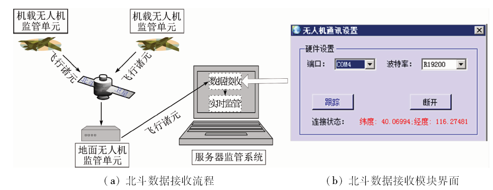
Abstract Using the Beidou navigation technology to supervise UAV flying operations is a new mode in the UAV flying supervisory system. This paper comprehensively presents the research idea, development environment and function structure of the latest system, and investigates in detail some key technologies such as registration of UAV resources and tasks, reception of Beidou flight parameters, UAV flying supervisory and alarm, and resources planning and allocation. Many kinds of test application show that the system has a reliable data transmission, stable supervision function and good visualization.
|
| Keywords
Beidou navigation technology
unmanned aerial vehicle(UAV)
flying supervisory
3D visualization
|
|
|
|
Issue Date: 30 May 2018
|
|
|
| [1] |
李德仁, 李明 . 无人机遥感系统的研究进展与应用前景[J]. 武汉大学学报(信息科学版), 2014,39(5):505-513.
doi: 10.13203/j.whugis20140045
url: http://www.cqvip.com/QK/92848A/201405/49497254.html
|
| [1] |
Li D R, Li M . Research advance and application prospect of unmanned aerial vehicle remote sensing system[J]. Geomatics and Information Science of Wuhan University, 2014,39(5):505-513.
|
| [2] |
范承啸, 韩俊, 熊志军 , 等. 无人机遥感技术现状与应用[J]. 测绘科学, 2009,34(5):214-215.
|
| [2] |
Fan C X, Han J, Xiong Z J , et al. Application and status of unmanned aerial vehicle remote sensing technology[J]. Science of Surveying and Mapping, 2009,34(5):214-215.
|
| [3] |
廖小罕, 周成虎 . 轻小型无人机遥感发展报告[M]. 北京: 科学出版社, 2016: 1-300.
|
| [3] |
Liao X H, Zhou C H. Light and Small UAV Remote Sensing Development Report[M]. Beijing: Science Press, 2016: 1-300.
|
| [4] |
唐远彬, 刘文, 任少华 . 基于无人机遥感技术的潮间带高程测量方法[J]. 国土资源遥感, 2013,25(2):42-46.doi: 10.6046/gtzyyg.2013.02.08.
doi: 10.6046/gtzyyg.2013.02.08
url: http://www.cqvip.com/QK/91397X/201302/45997231.html
|
| [4] |
Tang Y B, Liu W, Ren S H . Tideland height measurement based on UAV remote sensing and tidal observation[J]. Remote Sensing for Land and Resources, 2013,25(2):42-46.doi: 10.6046/gtzyyg.2013.02.08.
|
| [5] |
王利民, 刘佳, 杨玲波 , 等. 基于无人机影像的农情遥感监测应用[J]. 农业工程学报, 2013,29(18):136-145.
doi: 10.3969/j.issn.1002-6819.2013.18.017
url: http://d.wanfangdata.com.cn/Periodical/nygcxb201318017
|
| [5] |
Wang L M, Liu J, Yang L B , et al. Applications of unmanned aerial vehicle images on agricultural remote sensing monitoring[J]. Transactions of the Chinese Society of Agricultural Engineering, 2013,29(18):136-145.
|
| [6] |
赵星涛, 胡奎, 卢晓攀 , 等. 无人机低空航摄的矿山地质灾害精细探测方法[J]. 测绘科学, 2014,39(6):49-52,64.
url: http://d.wanfangdata.com.cn/Periodical/chkx201406011
|
| [6] |
Zhao X T, Hu K, Lu X P , et al. Precise detection method for mine geological disasters using low-altitude photogrammetry based on unmanned aerial vehicle[J]. Science of Surveying and Mapping, 2014,39(6):49-52,64.
|
| [7] |
丁雷龙, 李强子, 杜鑫 , 等. 基于无人机图像颜色指数的植被识别[J]. 国土资源遥感, 2016,28(1):78-86.doi: 10.6046/gtzyyg.2016.01.12.
doi: 10.6046/gtzyyg.2016.01.12
|
| [7] |
Ding L L, Li Q Z, Du X , et al. Vegetation extraction method based on color indices from UAV images[J]. Remote Sensing for Land and Resources, 2016,28(1):78-86.doi: 10.6046/gtzyyg.2016.01.12.
|
| [8] |
毕凯, 黄少林 . 无人机航测技术在农村土地调查工作底图制作中的应用[J]. 国土资源遥感, 2016,28(2):149-153.doi: 10.6046/gtzyyg.2016.02.23.
doi: 10.6046/gtzyyg.2016.02.23
url: http://d.wanfangdata.com.cn/Periodical/gtzyyg201602025
|
| [8] |
Bi K, Huang S L . Application of UAV aerophotogrammetry to base-map production in rural land survey[J]. Remote Sensing for Land and Resources, 2016,28(2):149-153.doi: 10.6046/gtzyyg.2016.02.23.
|
| [9] |
胡勇, 张孝成, 马泽忠 , 等. 无人机遥感影像中农村房屋信息快速提取[J]. 国土资源遥感, 2016,28(3):96-101.doi: 10.6046/gtzyyg.2016.03.16.
doi: 10.6046/gtzyyg.2016.03.16
url: http://d.wanfangdata.com.cn/Periodical/gtzyyg201603016
|
| [9] |
Hu Y, Zhang X C, Ma Z Z , et al. Rural residential area extraction from UAV remote sensing imagery[J]. Remote Sensing for Land and Resources, 2016,28(3):96-101.doi: 10.6046/gtzyyg.2016.03.16.
|
| [10] |
卢艳军, 刘季为, 张晓东 . 无人机地面站发展的分析研究[J]. 沈阳航空航天大学学报, 2014,31(3):60-64.
|
| [10] |
Lu Y J, Liu J W, Zhang X D . Analysis of the development of UAV GCS[J]. Journal of Shenyang Aerospace University, 2014,31(3):60-64.
|
| [11] |
Zhang J X, Yu T, Chen J P, et al. Design of ground monitor and control system for UAV remote sensing based on world wind [C]//Proceedings of the 3rd International Conference on Software Engineering and Service Science(ICSESS).Beijing,China:IEEE, 2012: 51-54.
|
| [12] |
杨林 .美国四家公司的无人机空管系统完成初步测试[EB/OL].( 2015- 10- 27)..
url: http://news.carnoc.com/list/327/327366.html
|
| [12] |
Yang L.Drone airspace management system of four American companies completed initial testing[EB/OL].( 2015- 10- 27)..
url: http://news.carnoc.com/list/327/327366.html
|
| [13] |
宇辰网.美国联邦航空管理局的无人机监管“壮举”[EB/OL].( 2016- 5- 16)..
url: http://www.cannews.com.cn/2016/0516/153838.shtml
|
| [13] |
YUCHEN.Unmanned aerial surveillance“feat”of Federal Aviation Administration[EB/OL].( 2016- 5- 16)..
url: http://www.cannews.com.cn/2016/0516/153838.shtml
|
| [14] |
赵孜 .U-Cloud正式上线,无人机监管迈出一大步[EB/OL].( 2016- 4- 18)..
url: http://www.yuchen360.com/news/7022-0-0.html
|
| [14] |
Zhao Z.U-Cloud officially online,unmanned aerial surveillance moved forward a big step[EB/OL].( 2016- 4- 18)..
url: http://www.yuchen360.com/news/7022-0-0.html
|
| [15] |
Bluesky.即时空管服务,GEO和AOPA U-Cloud谁能占得先机?[EB/OL].( 2015- 11- 22)..
url: http://www.loveuav.com/article-350-1.html
|
| [15] |
Bluesky.Real time air traffic control services,GEO and AOPA U-Cloud who can take the lead? [EB/OL].( 2015- 11- 22)..
url: http://www.loveuav.com/article-350-1.html
|
| [16] |
宇辰网.U-Care或将成为中国无人机空中交通管理系统[EB/OL].( 2015- 12- 30)..
url: http://www.youuav.com/news/detail/201512/2318.html
|
| [16] |
YUCHEN.U-Care may become the unmanned aerial traffic management system in China[EB/OL].( 2015- 12- 30)..
url: http://www.youuav.com/news/detail/201512/2318.html
|
|
Viewed |
|
|
|
Full text
|
|
|
|
|
Abstract
|
|
|
|
|
Cited |
|
|
|
|
| |
Shared |
|
|
|
|
| |
Discussed |
|
|
|
|
 2018,
Vol. 30
2018,
Vol. 30