|
|
 |
|

|
|
|
Geological information extraction based on remote sensing of unmanned aerial vehicle: Exemplified by Liujiang Basin |
LIAN Huiqing1( ), MENG Lu1(), HAN Ruigang1, YANG Yi1, YU Biao2 ), MENG Lu1(), HAN Ruigang1, YANG Yi1, YU Biao2 |
1. School of Safety Engineering, North China University of Science and Technology, Langfang 065201, China
2. School of Water Resources and Environment, China University of Geosciences(Beijing), Beijing 100083, China |
|
|
|
|
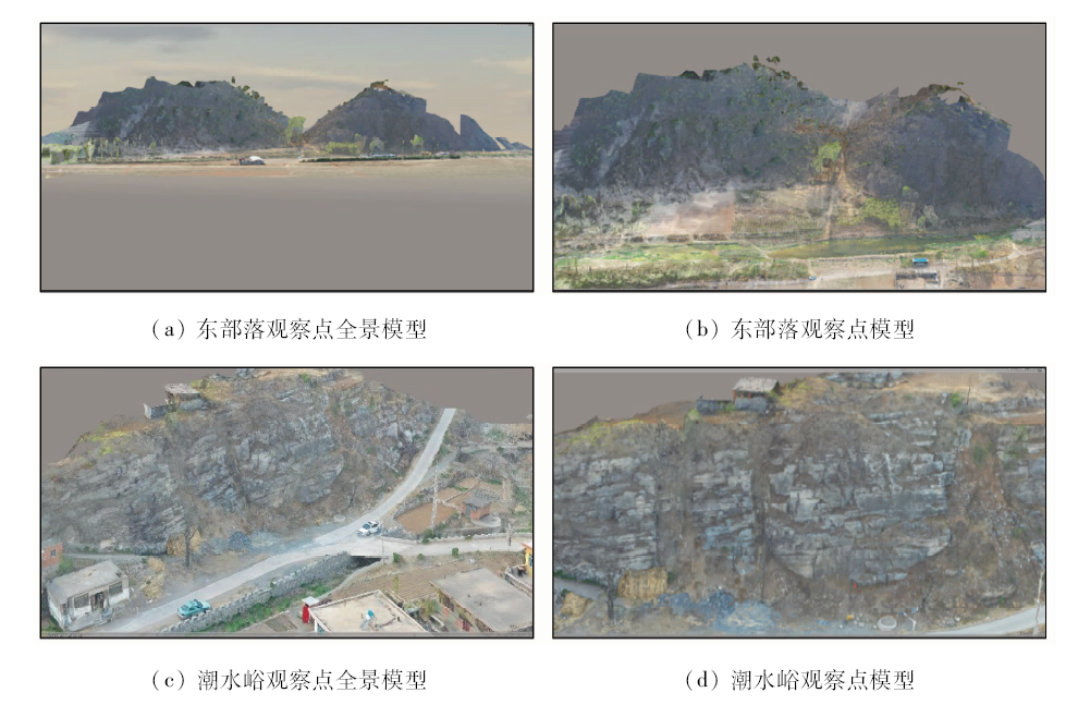
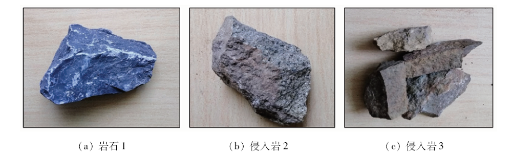
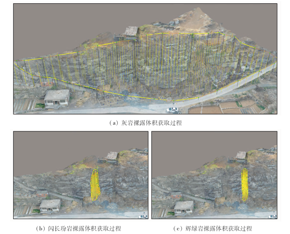
Abstract In order to solve the problem that the traditional geological survey has a large workload and low efficiency and that it is impossible to extract information from high slope geological points, the authors chose the Liujiang Basin in Qinhuangdao City, Hebei Province, as the research object. Oblique photogrammetry technology was used to obtain the image data of the study area. The generated image was used to construct a high-resolution 3D real-world model using the Context Capture software. The 3D model was identified and extracted in the Acute 3D viewer, including the extracted area’s latitude, longitude, and elevation. Several pieces of basic information were extracted, such as the distance between two points, the vertical distance, identification of the fault and calculation of the fault’s strike, tendency, and inclination, identification of the type and nature of the rock, and calculation of data such as perimeters, surface area, and volume value of the exposed rock. The results show that the extraction results are in good agreement with field measurements and can achieve the purpose of identifying geological phenomena and extracting geological quantitative information. It is shown that the method adopted in this paper has practical significance for geological information identification and extraction of UAV remote sensing technology.
|
| Keywords
oblique photography
drone image
three-dimensional modeling
geological information
Liujiang Basin
|
|
|
|
Corresponding Authors:
MENG Lu
E-mail: 2366884370@qq.com;376367920@qq.com
|
|
Issue Date: 09 October 2020
|
|
|
| [1] |
董秀军. 三维空间影像技术在地质工程中的综合应用研究[D]. 成都:成都理工大学, 2015.
|
| [1] |
Dong X J. Comprehensive application research of 3D spatial imaging technology in geological engineering[D]. Chengdu:Chengdu University of Technology, 2015.
|
| [2] |
董杨. 无人机影像拼接并行计算技术研究[D]. 北京:北京建筑大学, 2017.
|
| [2] |
Dong Y. Research on parallel computing technology of UAV image mosaic[D]. Beijing:Beijing University of Civil Engineering and Architecture, 2017.
|
| [3] |
金鼎坚, 王建超, 吴芳, 等. 航空遥感技术及其在地质调查中的应用[J]. 国土资源遥感, 2019,31(4):1-10.doi: 10.6046/gtzyyg.2019.04.01.
|
| [3] |
Jin D J, Wang J C, Wu F, et al. Aerial remote sensing technology and its applications in geological survey[J]. Remote Sensing for Land and Resources, 2019,31(4):1-10.doi: 10.6046/gtzyyg.2019.04.01.
|
| [4] |
Tonkin T N, Midgley N G, Graham D J, et al. The potential of small unmanned aircraft systems and structure-from-motion for topographic surveys:A test of emerging integrated approaches at Cwm Idwal North Wales[J]. Geomorphology, 2014,226(1-2):35-43.
|
| [5] |
鲁恒, 李永树, 何敬, 等. 无人机低空遥感影像数据的获取与处理[J]. 测绘工程, 2011,20(1):51-54.
|
| [5] |
Lu H, Li Y S, He J, et al. Acquisition and processing of low-altitude remote sensing image data of UAV[J]. Surveying and Mapping Engineering, 2011,20(1):51-54.
|
| [6] |
鲁恒, 李永树, 林先成. 无人机高空间分辨率影像分类研究[J]. 测绘科学, 2011,36(6):106-108.
|
| [6] |
Lu H, Li Y S, Lin X C. Research on high spatial resolution image classification of drones[J]. Science and Mapping Science, 2011,36(6):106-108.
|
| [7] |
Diaz-Varela R A, Zarco-Tejada P J, Angileri V, et al. Automatic identification of agricultural terraces through object-oriented analysis of very high resolution DSMs and multispectral imagery obtained from an unmanned aerial vehicle[J]. Journal of Environmental Management, 2014,134(4):117-126.
|
| [8] |
Gonalves J A, Henriques R. UAV photogrammetry for topographic monitoring of coastal areas[J]. ISPRS Journal of Photogrammetry and Remote Sensing, 2015,104:101-111.
doi: 10.1016/j.isprsjprs.2015.02.009
url: https://linkinghub.elsevier.com/retrieve/pii/S0924271615000532
|
| [9] |
荆平平, 李兵, 贾宗仁, 等. 基于无人机遥感的信息提取研究[J]. 测绘与空间地理信息, 2017,40(12):77-80.
|
| [9] |
Jing P P, Li B, Jia Z R, et al. Research on information extraction based on remote sensing of unmanned aerial vehicles[J]. Surveying and Spatial Geography Information, 2017,40(12):77-80.
|
| [10] |
姚林林, 张世殊, 赵明, 等. 基于无人机进行地质点信息提取方法研究[J]. 水电站设计, 2017,33(2):49-52.
|
| [10] |
Yao L L, Zhang S S, Zhao M, et al. Research on geological point information extraction method based on UAV[J]. Design of Hydroelectric Power Station, 2017,33(2):49-52.
|
| [11] |
殷强. 四旋翼无人机自主控制系统研究[D]. 天津:天津大学, 2012.
|
| [11] |
Yin Q. Research on autonomous control system of quadrotor UAV[D]. Tianjin:Tianjin University, 2012.
|
| [12] |
王猛. 河北省煤矿区瓦斯赋存的构造逐级控制[D].北京:中国矿业大学(北京),2012.
|
| [12] |
Wang M. Constructional control of gas occurrence in coal mining areas in Hebei Province[D].Beijing:China University of Mining and Technology(Beijing), 2012.
|
| [13] |
张路锁. 河北省煤田构造格局与构造控煤作用研究[D].北京:中国矿业大学(北京),2010.
|
| [13] |
Zhang L S. Study on the structural pattern and structural coal control of coalfields in Hebei Province[D].Beijing:China University of Mining and Technology(Beijing), 2010.
|
| [14] |
朱鹏程. 柳江盆地三维地质建模及核心区地下水资源量评价[D].北京:中国地质大学(北京),2017.
|
| [14] |
Zhu P C. Three-dimensional geological modeling of Liujiang Basin and evaluation of groundwater resources in core areas[D].Beijing:China University of Geosciences(Beijing), 2017.
|
| [15] |
郑怀文, 齐童. 柳江国家地质公园保护开发问题初探[J]. 首都师范大学学报(自然科学版), 2007,28(1):58-62,68.
|
| [15] |
Zheng H W, Qi T. A preliminary study on the protection and development of Liujiang National Geopark[J]. Journal of Capital Normal University (Natural Science Edition), 2007,28(1):58-62,68.
|
| [16] |
方小龙. 无人机倾斜摄影测量技术及其应用[J].百科论坛电子杂志, 2018(22):734-734.
|
| [16] |
Fang X L. UAV tilt photogrammetry technology and its application[J].Encyclopedia Forum E-Magazine 2018(22):734-734.
|
| [17] |
项小伟. 近景摄影辅助倾斜摄影的影像匹配及三维建模研究[D]. 太原:太原理工大学, 2019.
|
| [17] |
Xiang X W. Image matching and 3D modeling of close-range photography assisted inclined photography[D]. Taiyuan:Taiyuan University of Technology, 2019.
|
| [18] |
曹正阳, 张明. 无人机倾斜摄影测量技术及其应用[J]. 科技经济导刊, 2019,27(27):45.
|
| [18] |
Cao Z Y, Zhang M. UAV tilt photogrammetry and its application[J]. Technology and Economic Guide, 2019,27(27):45.
|
| [19] |
李策. 基于Context Capture倾斜摄影三维建模关键技术研究[D]. 唐山:华北理工大学, 2019.
|
| [19] |
Li C. Research on the key technology of 3D modeling of oblique photography based on Context Capture[D]. Tangshan:North China University of Technology, 2019.
|
| [20] |
祁生胜. 青海省东昆仑造山带火成岩岩石构造组合与构造演化[D].北京:中国地质大学(北京),2015.
|
| [20] |
Qi S S. Rock tectonic combination and tectonic evolution of the East Kunlun orogenic belt in Qinghai Province[D].Beijing:China University of Geosciences(Beijing), 2015.
|
| [21] |
陈玲, 贾佳, 王海庆. 高分遥感在自然资源调查中的应用综述[J]. 国土资源遥感, 2019,31(1):1-7.doi: 10.6046/gtzyyg.2019.01.01.
|
| [21] |
Chen L, Jia J, Wang H Q. An overview of applying high resolution remote sensing to natural resources survey[J]. Remote Sensing for Land and Resources, 2019,31(1):1-7.doi: 10.6046/gtzyyg.2019.01.01.
|
|
Viewed |
|
|
|
Full text
|
|
|
|
|
Abstract
|
|
|
|
|
Cited |
|
|
|
|
| |
Shared |
|
|
|
|
| |
Discussed |
|
|
|
|
 2020,
Vol. 32
2020,
Vol. 32