|
|
|
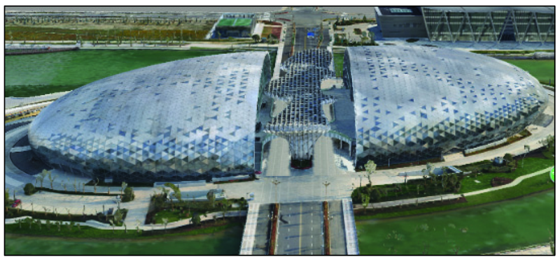
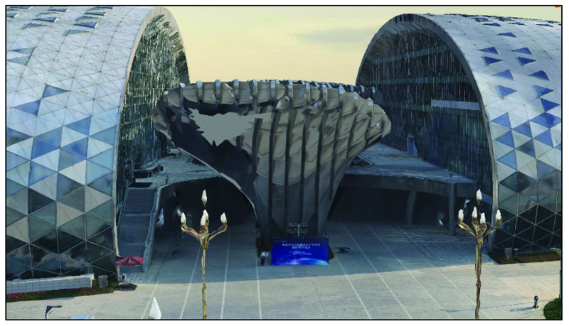
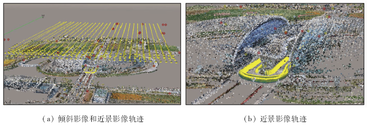
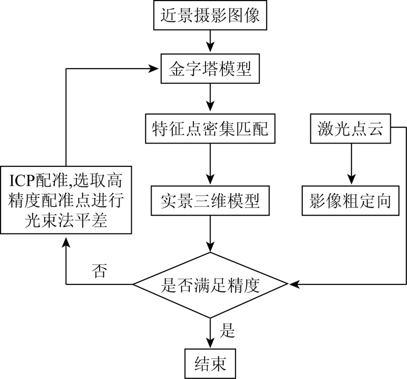
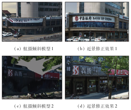
Abstract In close range oblique photography, there are problems of structural adhesion and distortion of 3D model caused by dead angle of aerial photography. In this study, based on a large number of close range images, the technology uses image processing techniques such as feature line matching, point cloud matching, texture mapping to fill in the blind area generated by oblique photography, so as to further optimize the structure and texture of the corresponding near earth model, realize the fine reconstruction, and solve the problem that it is difficult for the oblique photography model to browse near the ground. Comparative experiments show that the proposed method can improve the effect of close range correction to a certain extent and improve the visualization effect of oblique photography digital 3D imaging, thus providing reference for obtaining high-quality and high-precision 3D real scene model.
|
| Keywords
oblique photography
3D model
close range image
blind area repairing
|
|
|
|
Corresponding Authors:
ZENG Zhi
E-mail: wangya@zjccs.gov.cn;zengzhi@hzu.edu.cn
|
|
Issue Date: 18 March 2021
|
|
|
| [1] |
曲林, 冯洋, 支玲美, 等. 基于无人机倾斜摄影数据的实景三维建模研究[J]. 测绘与空间地理信息, 2015(3):38-39,43.
|
| [1] |
Qu L, Feng Y, Zhi L M, et al. Study on real 3D modeling of photographic data based on UAV[J]. Geomatics and Spatial Information Technology, 2015(3):38-39,43.
|
| [2] |
沈大勇, 蒙印, 杨井源, 等. 倾斜摄影实景三维模型空洞修补技术的研究[J]. 测绘, 2014,37(6):250-253
|
| [2] |
Shen D Y, Meng Y, Yang J Y, et al. Research on repairing technolo-gy of holes of real 3D model based on oblique photography[J]. Surveying and Mapping, 2014,37(6):250-253.
|
| [3] |
于庆, 王结臣, 陈焱明. 一种三角网边界提取的方法[J]. 测绘科学, 2009(s2):122-125
|
| [3] |
Yu Q, Wang J C, Chen Y M. A method of boundary extraction for triangle mesh[J]. Science of Surveying and Mapping, 2009(s2):122-125.
|
| [4] |
吕翠华, 陈秀萍. 基于三维激光扫描技术的建筑物三维建模方法[J]. 科学技术与工程, 2012,12(10):2410-2414.
|
| [4] |
Lyu C H, Chen X P. The building 3D modeling method based on 3D laser scanning technology[J]. Science Technology and Engineering, 2012,12(10):2410-2414.
|
| [5] |
刘震, 白丽丽, 缪永伟. 基于特征线的三维模型孔洞修复方法[J]. 浙江工业大学学报, 2015,43(3):346-349.
|
| [5] |
Liu Z, Bai L L, Miao Y W. The repair methods for hole of three-dimentional model based on feature line[J]. Journal of Zhejiang University of Technology, 2015,43(3):346-349.
|
| [6] |
谭仁春, 李鹏鹏, 文琳, 等. 无人机倾斜摄影的城市三维建模方法优化[J]. 测绘通报, 2016(11):39-42.
|
| [6] |
Tang R C, Li P P, Wen L, et al. Improvement of 3D urban modeling method based on unmanned aerial vehicle oblique photography[J]. Bulletin of Surveying and Mapping, 2016(11):39-42.
|
| [7] |
李厚强, 王超, 叶中付, 等. 一种改进的基于Gabor滤波器的纹理分割方法[J]. 电路与系统学报, 2003(6):82-86.
|
| [7] |
Li H Q, Wang C, Ye Z F, et al. An improved method for texture segmentation based on Gabor filters[J]. Journal of Circuits and Systems, 2003(6):82-86.
|
| [8] |
强振平, 何丽波, 陈旭, 等. 深度学习图像修复方法综述[J]. 中国图象图形学报, 2019,24(3):447-463.
|
| [8] |
Qiang Z P, He L B, Chen X, et al. Survey on deep learning image inpainting methods[J]. Journal of Image and Graphics, 2019,24(3):447-463.
|
| [9] |
周行行, 邹峥嵘, 张云生, 等. 顾及几何及颜色信息的倾斜影像立面点云提取[J]. 国土资源遥感, 2016,28(4):43-48.doi: 10.6046/gtzyyg.2016.04.07.
|
| [9] |
Zhou H H, Zou Z R, Zhang Y S, et al. Facade extraction from oblique point cloud considering geometrical and color information[J]. Remote Sensing for Land and Resources, 2016,28(4):43-48.doi: 10.6046/gtzyyg.2016.04.07.
|
| [10] |
Feng C, Liang J, Ren M, et al. A fast hole-filling method for triangular mesh in additive repair[J]. Applied Sciences, 2020,10(3):969.
|
| [11] |
Sheng B, Zhao F, Yin X, et al. A lightweight surface reconstruction method for online 3D scanning point cloud data oriented toward 3D printing[J]. Mathematical Problems in Engineering, 2018(1):1-16.
|
| [12] |
Toschi I, Ramos M M, Nocerino E, et al. Oblique photogrammetry supporting 3D urban reconstruction of complex scenarios[J]. ISPRS-International Archives of the Photogrammetry,Remote Sensing and Spatial Information Sciences,XLII- 1/W1:519-526.
|
|
Viewed |
|
|
|
Full text
|
|
|
|
|
Abstract
|
|
|
|
|
Cited |
|
|
|
|
| |
Shared |
|
|
|
|
| |
Discussed |
|
|
|
|
 2021,
Vol. 33
2021,
Vol. 33
 ), ZENG Zhi2(