|
|
|
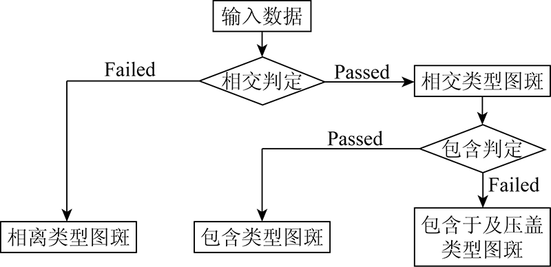
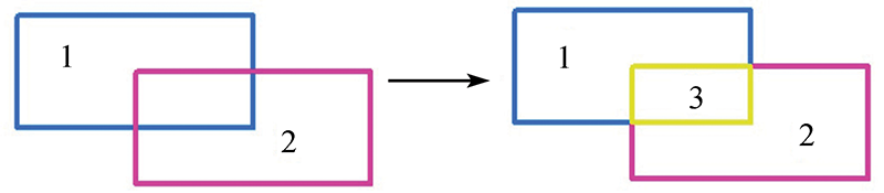
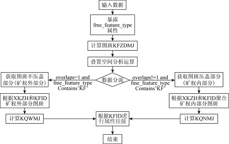
Abstract The vector data of mines in China obtained from remote sensing-based monitoring are characterized by wide coverage, high complexity, and high accuracy of area statistics. However, existing software suffers low calculation efficiency and low accuracy. This study proposed a solution based on the feature manipulation engine (FME) platform. This solution consists of the following steps. Firstly, the vector data of mines were divided into zones according to the locations of polygons and mineral rights. Secondly, the positions of the polygons relative to mineral rights were analyzed, obtaining four types of polygons, namely being separated from, containing, being contained in, and covering mineral rights. Finally, relevant area of mines was calculated, including the development area (KFZDMJ), the area covered by mining right (KQNMJ), and the area uncovered by mining right (KQWMJ) according to the types of relative position relationships. The solution was verified using the vector data of mines in a medium-sized province. According to the verification results, the solution proposed in this study can greatly improve calculation efficiency and accuracy and its operation is feasible and straightforward. The results show that the consistency checking of the map attributes can provide effective support for the compilation of remote sensing-based monitoring data of mines and can be widely applied.
|
| Keywords
cartography technology
remote sensing-based monitoring of mines
attribute consistency checking
FME
|
|
|
|
Corresponding Authors:
XU Zhengqiang
E-mail: 282926660@qq.com;84008181@qq.com
|
|
Issue Date: 14 March 2022
|
|
|
| [1] |
杨显华, 黄洁, 田立, 等. 基于高分辨率遥感数据的矿山环境综合治理研究——以冕宁牦牛坪稀土矿为例[J]. 自然资源遥感, 2015, 27(4):115-121.doi: 10.6046/gtzyyg.2015.04.18.
doi: 10.6046/gtzyyg.2015.04.18
|
| [1] |
Yang X H, Huang J, Tian L, et al. A discussion on comprehensive governance of mine environment based on high resolution remote sensing data: A case of Maoniuping REE deposit,Mianning County[J]. Remote Sensing for Land and Resources, 2015, 27(4):115-121.doi: 10.6046/gtzyyg.2015.04.18.
doi: 10.6046/gtzyyg.2015.04.18
|
| [2] |
程乾, 陈金凤. 基于高分1号杭州湾南岸滨海陆地土地覆盖信息提取方法研究[J]. 自然资源学报, 2015, 30(2):350-360.
|
| [2] |
Cheng Q, Chen J F. Research on the extraction method of landcover information in southern coatal land of Hangzhou Bay based on GF-1 image[J]. Journal of Natural Resources, 2015, 30(2):350-360.
|
| [3] |
杨金中, 聂洪峰, 荆青青. 初论全国矿山地质环境现状与存在问题[J]. 自然资源遥感, 2017, 29(2):1-7.doi: 10.6046/gtzyyg.2017.02.01.
doi: 10.6046/gtzyyg.2017.02.01
|
| [3] |
Yang J Z, Nie H F, Jing Q Q. Preliminary analysis of mine geoenvironment status and existing problems in China[J]. Remote Sensing for Land and Resources, 2017, 29(2):1-7.doi: 10.6064/gtzyyg.2017.02.01.
doi: 10.6064/gtzyyg.2017.02.01
|
| [4] |
杨金中, 秦绪文, 张志, 等. 矿山遥感监测理论方法与实践[M]. 北京: 测绘出版社, 2011:137-154.
|
| [4] |
Yang J Z, Qin X W, Zhang Z, et al. Theory and practice on remote sensing monitoring of mine[M]. Beijing: Surveying and Mapping Publishing House, 2011:137-154.
|
| [5] |
中国自然资源航空物探遥感中心. 矿山遥感数据入库要求(2019版)[Z]. 北京:中国自然资源航空物探遥感中心, 2019.
|
| [5] |
China Aero Geophysical Survey and Remote Sensing Center for Natural Resources.Production for data requirements for database of mine remote sensing monitoring(2019)[Z]. Beijing:China Aero Geophysical Survey and Remote Sensing Center for Natural Resources,2019.
|
| [6] |
杨金中, 荆青青, 聂洪峰. 全国矿产资源开发状况遥感监测工作简析[J]. 矿产勘查, 2016, 7(2):359-363.
|
| [6] |
Yang J Z, Jing Q Q, Nie H F, Analysis of the mineral resources development status of remote sensing monitoring in national land[J]. Mineral Exploration, 2016, 7(2):359-363.
|
| [7] |
刁明光, 瞿翟, 薛涛, 等. 基于AE插件式矿山遥感监测成果数据质量检查系统[J]. 自然资源遥感, 2017, 29(4):219-224.doi: 10.6046/gtzyyg.2017.04.33.
doi: 10.6046/gtzyyg.2017.04.33
|
| [7] |
Diao M G, Qu D, Xue T, et al. Plug-in style results data quality checking system for mine remote sensing monitoring based on AE[J]. Remote Sensing for Land and Resources, 2017, 29(4):229-224.doi: 10.6046/gtzyyg.2017.04.33.
doi: 10.6046/gtzyyg.2017.04.33
|
| [8] |
刁明光, 瞿翟, 梁建东, 等. 矿山遥感监测属性数据复杂约束类型的描述方法[J]. 自然资源遥感, 2016, 28(3):197-201.doi: 10.6046/gtzyyg.2017.04.30.
doi: 10.6046/gtzyyg.2017.04.30
|
| [8] |
Diao M G, Qu D, Liang J D, et al. Description method for complex constraint of mine remote sensingg monitoring attribute data[J]. Remote Sensing for Land and Resources, 2016, 28(3):197-201.doi: 10.6046/gtzyyg.2017.04.30.
doi: 10.6046/gtzyyg.2017.04.30
|
| [9] |
方靖. 基于ArcGIS平台的三调初始库快速编制技术研究[J]. 国土资源导刊, 2019, 16(2):29-34.
|
| [9] |
Fang J. The study into rapid compiling of the initial database for the third national land survey based on ArcGIS platform[J]. Land and Resources Herald, 2019, 16(2):29-34.
|
| [10] |
张康聪. 地理信息系统导论[M]. 北京: 科学出版社, 2019.
|
| [10] |
Zhang K C. Introduction to geographic information systems[M]. Beijing: Science Press, 2019.
|
| [11] |
张毅, 李国卿, 赵军喜, 等. 插件式GIS应用框架关键技术研究[J]. 测绘科学技术学报, 2010, 27(4):298-301.
|
| [11] |
Zhang Y, Li G Q, Zhao J X, et al. Key technoloty of plugin-based GIS application framework[J]. Journal of Geomatics Science and Technology, 2010, 27(4):298-301.
|
|
Viewed |
|
|
|
Full text
|
|
|
|
|
Abstract
|
|
|
|
|
Cited |
|
|
|
|
| |
Shared |
|
|
|
|
| |
Discussed |
|
|
|
|
 2022,
Vol. 34
2022,
Vol. 34
 ), XIONG Liyuan, XU Zhengqiang(