|
|
 |
|
|
|
|
Research and implementation of rapid statistical methods for mine remote sensing monitoring indicators |
Xi LIU1,2, Lina HAO1( ), Xianhua YANG3, Jie HUANG3, Zhi ZHANG4, Wunian YANG1 ), Xianhua YANG3, Jie HUANG3, Zhi ZHANG4, Wunian YANG1 |
1. Chengdu University of Technology, Faculty of Earth Sciences, Chengdu 610059, China
2. Sichuan Basic Geographic Information Center, Ministry of Natural Resources, Chengdu 610093, China
3. Sichuan Institute of Geological Survey, Chengdu 610081, China
4. School of Geophysics and Spatial Information, China University of Geosciences (Wuhan), Wuhan 430074, China |
|
|
|
|
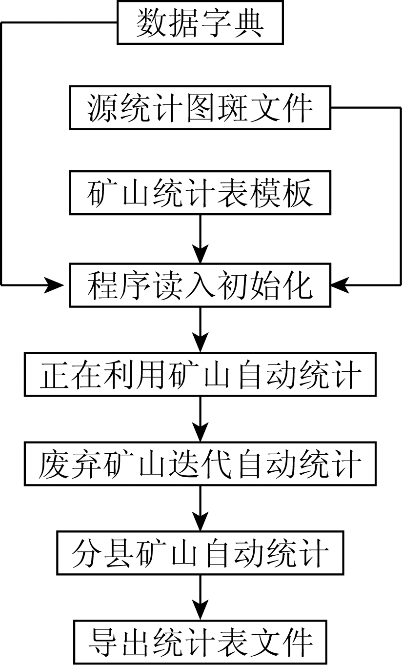
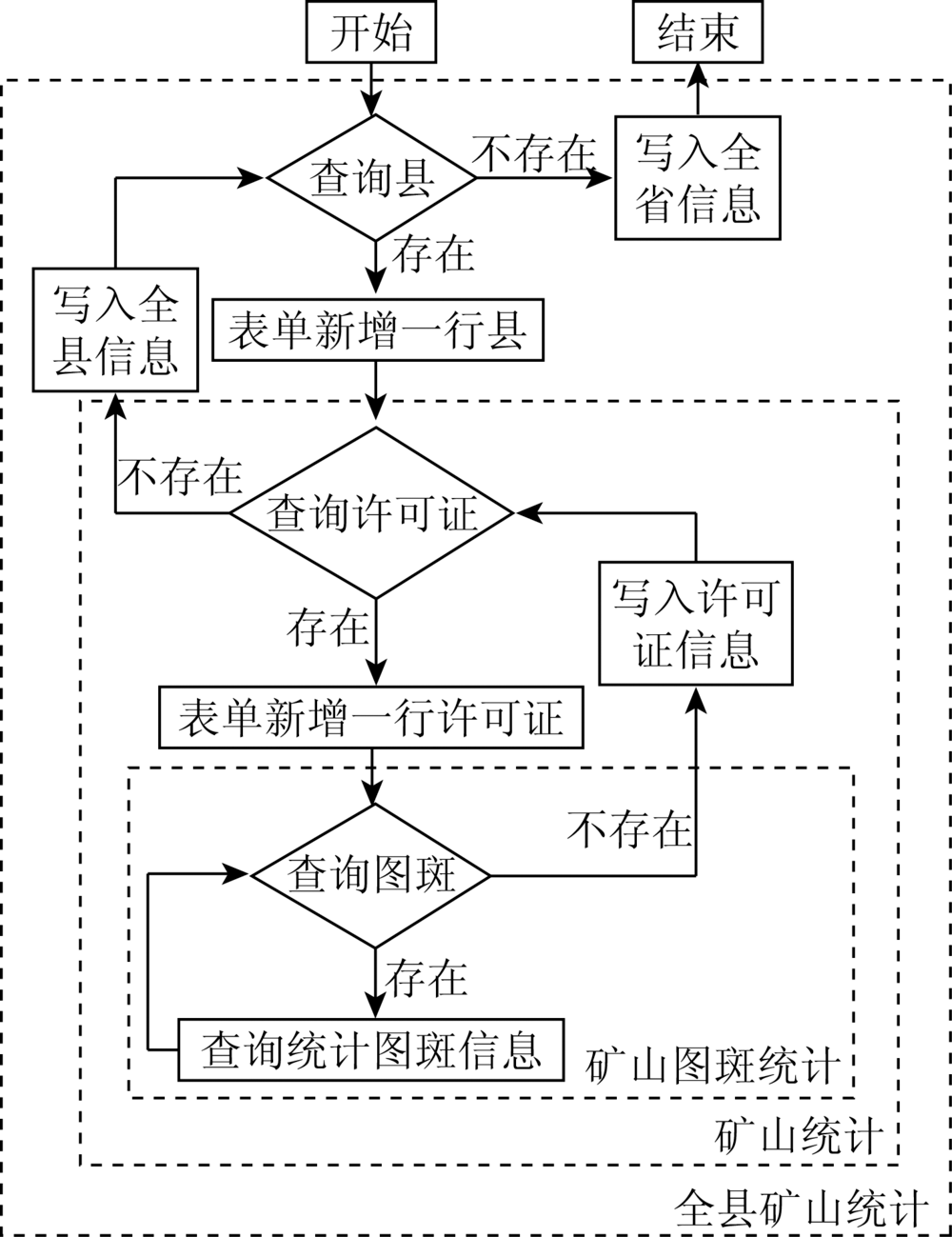
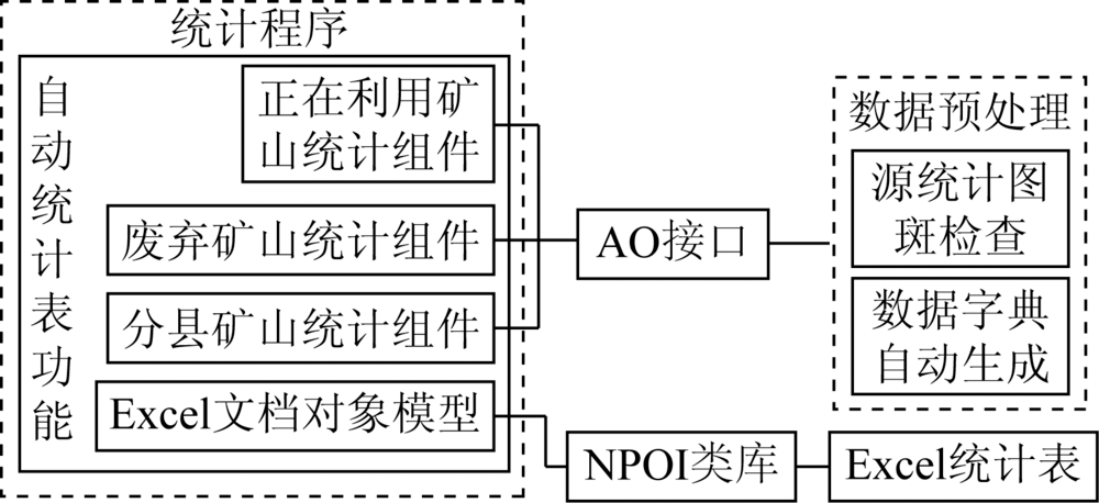
Abstract In the implementation of mine development and mine remote sensing environment monitoring, the statistical calculation of monitoring data indicators is one of the main methods for the centralized display and application of monitoring results, and is also the basis for relevant law enforcement and provides data support for the adjustment and formulation of relevant mine policies. In calculating various monitoring indicators, traditional manual statistics have many shortcomings such as low efficiency, high labor cost, large workload, wrong calculation, low accuracy, and inconsistent statistical standards. Through the project practice, the paper puts forward the automatic statistical method of mine remote sensing monitoring based on data stream filtering and multi-dimensional matrix calculation, which can quickly count the attribute information and spatial information of each mine remote sensing monitoring data, realize the calculation of each classification index according to the administrative region and mine type statistics, and complete the rapid summary of mine statistical indicators. The experimental results show that the proposed method completed the statistical summary task quickly, accurately and automatically in the remote sensing monitoring project of Qinghai Province in 2018, thus saving a lot of human resources and time and having a good application effect.
|
| Keywords
mine remote sensing monitoring
data stream filtering
multidimensional matrix calculation
automatic statistics
statistical indicators
|
|
|
|
Corresponding Authors:
Lina HAO
E-mail: hao_ln@qq.com
|
|
Issue Date: 18 June 2020
|
|
|
| [1] |
周进生, 牛建英, 张旭, 等. 矿山遥感监测评估特点与指标体系[J]. 国土资源遥感, 2014,26(2):1-4.doi: 10.6046/gtzyyg.2014.02.01.
|
| [1] |
Zhou J S, Niu J Y, Zhang X, et al. Characteristics and index system of mine remote sensing monitoring and evaluation[J]. Remote Sensing for Land and Resources, 2014,26(2):1-4.doi: 10.6046/gtzyyg.2014.02.01.
|
| [2] |
杨振山, 蔡建明. 空间统计学进展及其在经济地理研究中的应用[J]. 地理科学进展, 2010,29(06):757-768.
|
| [2] |
Yang Z S, Cai J M. The progress of spatial statistics and its application in economic geography research[J]. Progress in Geography, 2010,29(06):757-768.
|
| [3] |
杨兴华, 宋宝燕, 欧征宇, 等. 一种支持数据流条件过滤的批处理策略[J].计算机科学, 2004(11):118-120.
|
| [3] |
Yang X H, Song B Y, Ou Z Y, et al. A batch processing strategy supporting data flow condition filtering[J].Computer Science, 2004(11):118-120.
|
| [4] |
尹燕. 一种XML数据流查询过滤算法[D]. 山西大学, 2010.
|
| [4] |
Yin Y. An XML Data Stream Query Filtering Algorithm[D]. Shanxi University, 2010.
|
| [5] |
鞠瑞年. 多维矩阵基本运算[J]. 中国新通信, 2017,19(2):137-138.
|
| [5] |
Qi R N. Basic operations of multidimensional matrix[J]. China New Communications, 2017,19(2):137-138.
|
| [6] |
刁明光, 薛涛, 李建存, 等. 基于ArcGIS的矿山遥感监测成果编制系统[J]. 国土资源遥感, 2016,28(3):194-199.doi: 10.6046/gtzyyg.2016.04.30.
|
| [6] |
Diao M G, Xue T, Li J C, et al. Architecture system of mine remote sensing monitoring based on ArcGIS[J]. Remote Sensing for Land and Resources, 2016,28(3):194-199.doi: 10.6046/gtzyyg.2016.04.30.
|
| [7] |
刁明光, 瞿翟, 薛涛, 等. 基于AE插件式矿山遥感监测成果数据质量检查系统[J]. 国土资源遥感, 2017,29(4):219-224.doi: 10.6046/gtzyyg.2017.04.33.
|
| [7] |
Diao M G, Qu D, Xue T, et al. Data quality inspection system based on AE plug-in mine remote sensing monitoring results[J]. Remote Sensing for Land and Resources, 2017,29(4):219-224.doi: 10.6046/gtzyyg.2017.04.33.
|
| [8] |
刁明光, 刘芳, 谭专条, 等. 矿山遥感监测解译记录表自动生成方法研究与实现[J]. 国土资源遥感, 2018,30(4):212-217.doi: 10.6046/gtzyyg.2018.04.32.
|
| [8] |
Diao M G, Liu F, Tan Z T, et al. Research and implementation of automatic generation method of mine remote sensing monitoring interpretation record table[J]. Remote Sensing for Land and Resources, 2018,30(4):212-217.doi: 10.6046/gtzyyg.2018.04.32.
|
| [9] |
随欣欣, 眭素文. 基于MapGIS和ArcGIS的遥感解译成果图件数据库设计与实现[J]. 国土资源遥感, 2018,30(4):218-224.doi: 10.6046/gtzyyg.2018.04.33.
|
| [9] |
Sui X X, Yan S W. Design and implementation of remote sensing interpretation results map database based on MapGIS and ArcGIS[J]. Remote Sensing for Land and Resources, 2018,30(4):218-224.doi: 10.6046/gtzyyg.2018.04.33.
|
| [10] |
随欣欣, 眭素文, 刘锟. 面向遥感业务应用的解译成果数据管理系统研究和构建[J]. 国土资源遥感, 2018,30(3):238-243.doi: 10.6046/gtzyyg.2018.03.32.
|
| [10] |
Sui X X, Yan S W, Liu Wei. Research and construction of data management system for interpretation results for remote sensing business applications[J]. Remote Sensing of Land and Resources, 2018,30(3):238-243.doi: 10.6046/gtzyyg.2018.03.32.
|
| [11] |
中国国土资源航空物探遥感中心.全国矿产资源开发环境遥感监测入库数据技术要求(2017)[Z]. 2017-9
|
| [11] |
China Aero Geophysical and Remote Sensing Center for Land and Resources.A National Mineral Resources Development Environment Remote Sensing Monitoring Data Requirements for Technical Data(2017)[Z].2017-9.
|
|
Viewed |
|
|
|
Full text
|
|
|
|
|
Abstract
|
|
|
|
|
Cited |
|
|
|
|
| |
Shared |
|
|
|
|
| |
Discussed |
|
|
|
|
 2020,
Vol. 32
2020,
Vol. 32