|
|
 |
|

|
|
|
Integrated remote sensing-based hazard identification and disaster-causing mechanisms of landslides in Zayu County |
CAI Jian’ao1( ), MING Dongping1,2(), ZHAO Wenyi1,3, LING Xiao1, ZHANG Yu1, ZHANG Xingxing1 ), MING Dongping1,2(), ZHAO Wenyi1,3, LING Xiao1, ZHANG Yu1, ZHANG Xingxing1 |
1. School of Information Engineering, China University of Geosciences(Beijing), Beijing 100083, China
2. Frontiers Science Center for Deep-time Digital Earth, China University of Geosciences (Beijing), Beijing 100083, China
3. China Geological Environment Monitoring Institute, Beijing 100081, China |
|
|
|
|
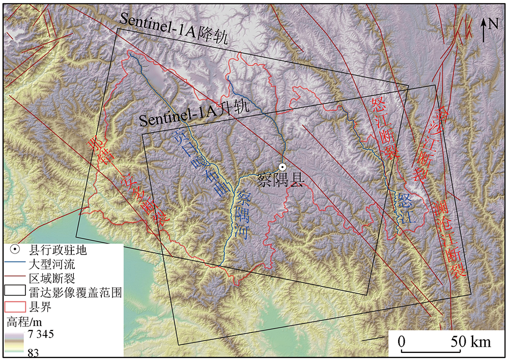
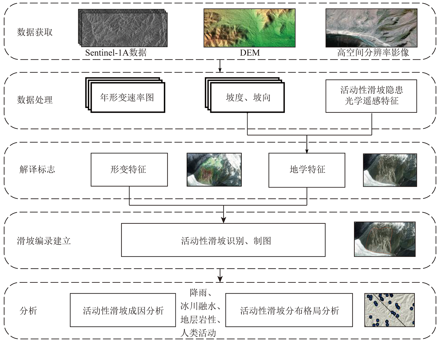
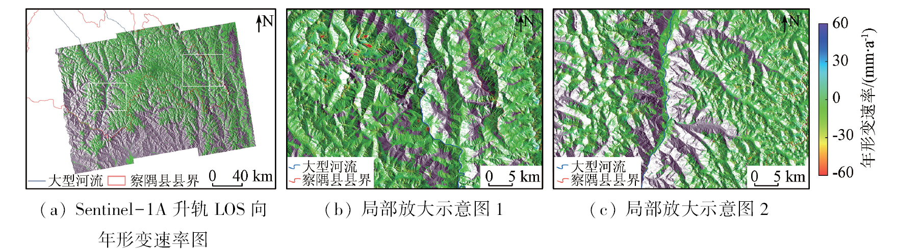
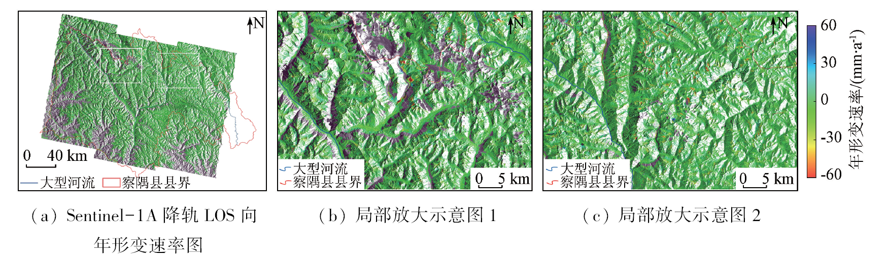
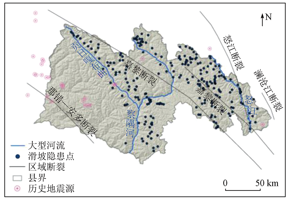
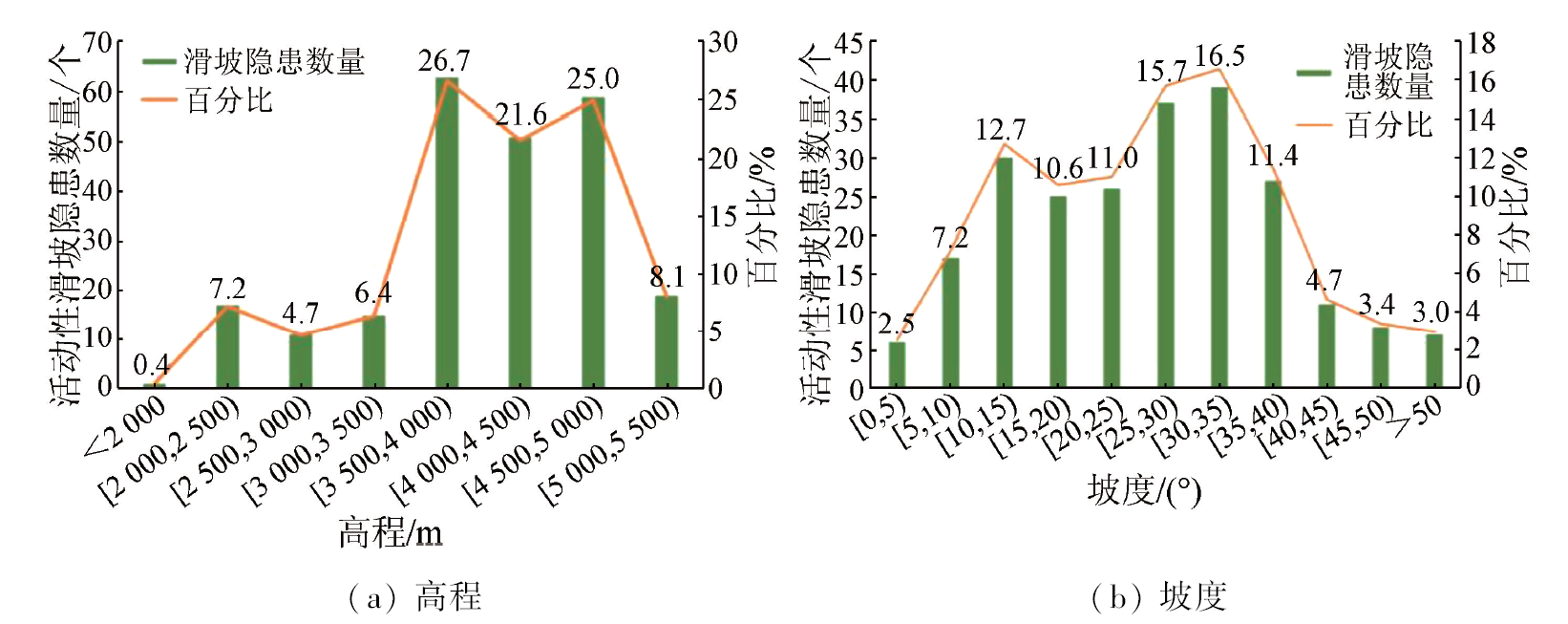
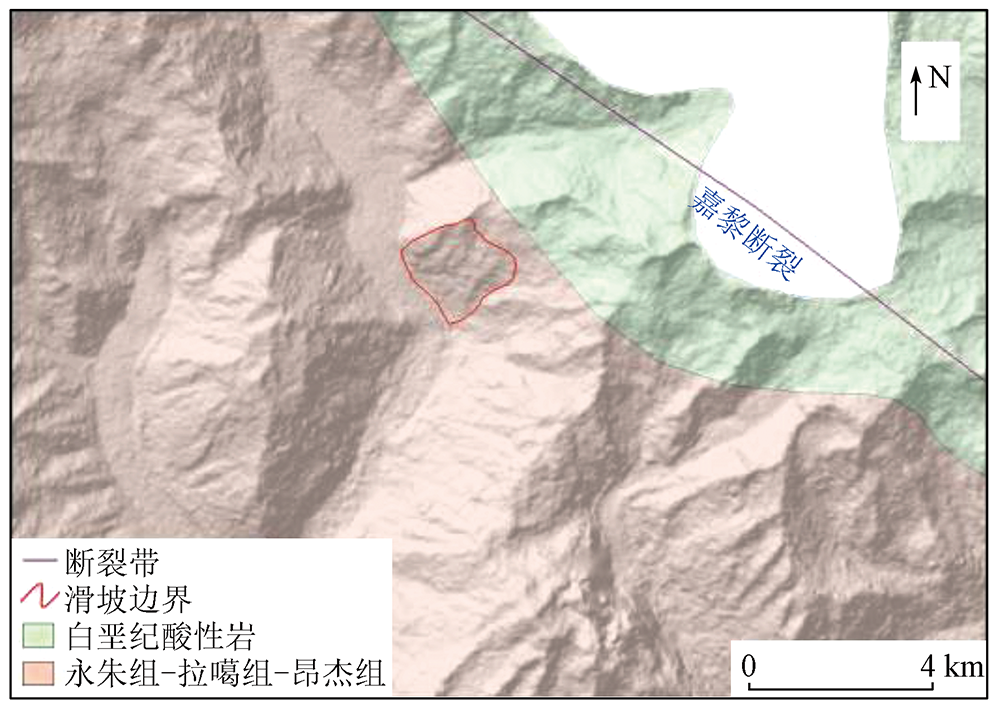
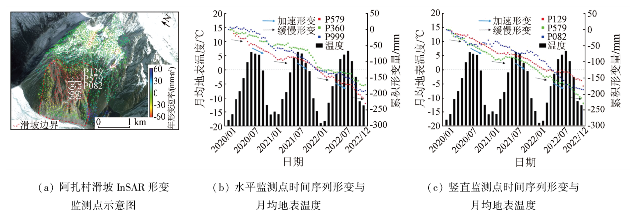
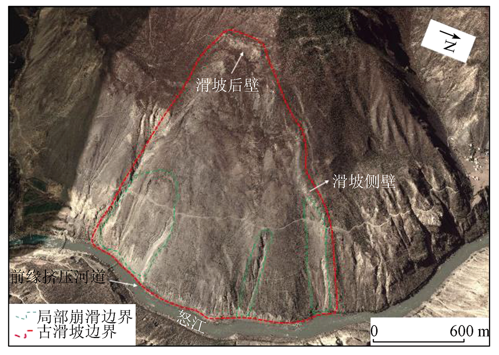
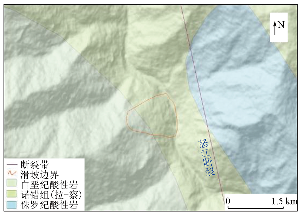
Abstract Zayu County, located in the southeastern portion of the Qinghai-Tibet Plateau, is characterized by a large area, significantly varying topographic and climatic characteristics, and frequent landslides. The hazard identification and early warning of landslides are critical to disaster prevention and mitigation in the county. Based on the data acquired from January 2020 to November 2022, including 162 scenes of Sentinel-1A Radar remote sensing images taken on ascending and descending passes and high-resolution optical remote sensing images, this study conducted hazard identification, cataloging, mapping, analysis, and assessment of active landslides in Zayu County using the integrated remote sensing (IRS) technique on the Google Earth platform. A total of 237 active landslide hazards were identified primarily along the Gongrigabuqu River (the western tributary of the Zayu River), Zayu River, both sides of the Nujiang River, and the eastern Zayu River to the western Nujiang River. As revealed by the statistical analysis of the interpretation results combined with quantitative factors such as topography (elevation, slope, lithology) and natural environment (rainfall, temperature), the landslides in Zuobu and Azha villages pose high disaster risks, necessitating further mitigation measures. With relatively accurate results, this study can serve as a reference for disaster prevention and mitigation in Zayu County.
|
| Keywords
integrated remote sensing (IRS)
small baseline subset-interferometric synthetic aperture Radar (SBAS-InSAR)
Zayu County
active landslide
landslide monitoring
|
|
|
|
Issue Date: 13 March 2024
|
|
|
| [9] |
Wang D F, Li Y X, Ren J, et al. Application of Joint UAV Optics and Airborne LiDAR in high level landslide element identification:Taking the Longxigou landslide in Wenchuan,West Sichuan as an example[J/OL]. Geoscience, 2023.https://doi.org/10.19657/j.geoscience.1000-8527.2023.101.
url: https://doi.org/10.19657/j.geoscience.1000-8527.2023.101
|
| [10] |
张雨, 明冬萍, 赵文祎, 等. 基于高分光学卫星影像的泸定地震型滑坡提取与分析[J]. 自然资源遥感, 2023, 35(1):161-170.doi:10.6046/zrzyyg.2022434.
|
| [10] |
Zhang Y, Ming D P, Zhao W Y, et al. The extraction and analysis of Luding earthquake-induced landslide based on high-resolution optical satellite images[J]. Remote Sensing for Natural Resources, 2023, 35(1):161-170.doi:10.6046/zrzyyg.2022434.
|
| [11] |
赵华伟, 周林, 谭明伦, 等. 基于光学遥感和SBAS-InSAR的川渝输电网滑坡隐患早期识别[J/OL]. 自然资源遥感, 2023(2023-04-24). https://kns.cnki.net/kcms/detail/10.1759.P.20230423.1809.008.html.
url: https://kns.cnki.net/kcms/detail/10.1759.P.20230423.1809.008.html
|
| [11] |
Zhao H W, Zhou L, Tan M L, et al. Early identification of landslide hidden danger in Sichuan-Chongqing power transmission network based on optical remote sensing and SBAS-InSAR[J/OL]. Remote Sensing for Natural Resources, 2023(2023-04-24). https://kns.cnki.net/kcms/detail/10.1759.P.20230423.1809.008.html.
url: https://kns.cnki.net/kcms/detail/10.1759.P.20230423.1809.008.html
|
| [12] |
杨昭颖, 韩灵怡, 郑向向, 等. 基于卷积神经网络的遥感影像及DEM滑坡识别——以黄土滑坡为例[J]. 自然资源遥感, 2022, 34(2):224-230.doi:10.6046/zrzyyg.2021204.
|
| [12] |
Yang Z Y, Han L Y, Zheng X X, et al. Landslide identification using remote sensing images and DEM based on convolutional neural network:A case study of loess landslide[J]. Remote Sensing for Natural Resources, 2022, 34(2):224-230.doi:10.6046/zrzyyg.2021204.
|
| [13] |
Li L, Yao X, Zhang Y, et al. Surface recovery of landslides triggered by 2008 Ms8.0 Wenchuan earthquake (China):A case study in a typical mountainous watershed[J]. Landslides, 2016, 13(4):787-794.
doi: 10.1007/s10346-015-0594-1
url: http://link.springer.com/10.1007/s10346-015-0594-1
|
| [14] |
董继红, 马志刚, 梁京涛, 等. 基于时序InSAR技术的滑坡隐患识别对比研究[J]. 自然资源遥感, 2022, 34(3):73-81.doi:10.6046/zrzyyg.2021333.
|
| [14] |
Dong J H, Ma Z G, Liang J T, et al. A comparative study of the identification of hidden landslide hazards based on time series InSAR techniques[J]. Remote Sensing for Natural Resources, 2022, 34(3):73-81.doi:10.6046/zrzyyg.2021333.
|
| [15] |
Shi X, Xu Q, Zhang L, et al. Surface displacements of the Heifangtai Terrace in Northwest China measured by X and C-band InSAR observations[J]. Engineering Geology, 2019, 259:105181.
doi: 10.1016/j.enggeo.2019.105181
url: https://linkinghub.elsevier.com/retrieve/pii/S0013795219302303
|
| [16] |
刘晓杰. 星载雷达遥感广域滑坡早期识别与监测预测关键技术研究[D]. 西安: 长安大学, 2022.
|
| [16] |
Liu X J. Research on key technologies for early identification,monitoring and forecasting of wide-area landslides with spaceborne radar remote sensing[D]. Xi’an: Chang’an University, 2022.
|
| [17] |
Hilley G E, Bürgmann R, Ferretti A, et al. Dynamics of slow-moving landslides from permanent scatterer analysis[J]. Science, 2004, 304(5679):1952-1955.
pmid: 15218146
|
| [18] |
Lanari R, Mora O, Manunta M, et al. A small-baseline approach for investigating deformations on full-resolution differential SAR interferograms[J]. IEEE Transactions on Geoscience and Remote Sensing, 2004, 42(7):1377-1386.
doi: 10.1109/TGRS.2004.828196
url: http://ieeexplore.ieee.org/document/1315820/
|
| [19] |
Ferretti A, Fumagalli A, Novali F, et al. A new algorithm for processing interferometric data-stacks:SqueeSAR[J]. IEEE Transactions on Geoscience and Remote Sensing, 2011, 49(9):3460-3470.
doi: 10.1109/TGRS.2011.2124465
url: http://ieeexplore.ieee.org/document/5765671/
|
| [20] |
Dong J, Liao M, Xu Q, et al. Detection and displacement characterization of landslides using multi-temporal satellite SAR interferometry:A case study of Danba County in the Dadu River basin[J]. Engineering Geology, 2018, 240:95-109.
doi: 10.1016/j.enggeo.2018.04.015
url: https://linkinghub.elsevier.com/retrieve/pii/S0013795217310736
|
| [21] |
葛大庆, 戴可人, 郭兆成, 等. 重大地质灾害隐患早期识别中综合遥感应用的思考与建议[J]. 武汉大学学报(信息科学版), 2019, 44(7):949-956.
|
| [21] |
Ge D Q, Dai K R, Guo Z C, et al. Early identification of serious geological hazards with integrated remote sensing technologies:Thoughts and recommendations[J]. Geomatics and Information Science of Wuhan University, 2019, 44(7):949-956.
|
| [22] |
陆会燕, 李为乐, 许强, 等. 光学遥感与InSAR结合的金沙江白格滑坡上下游滑坡隐患早期识别[J]. 武汉大学学报(信息科学版), 2019, 44(9):1342-1354.
|
| [22] |
Lu H Y, Li W L, Xu Q, et al. Early detection of landslides in the upstream and downstream areas of the baige landslide,the Jinsha River based on optical remote sensing and InSAR technologies[J]. Geomatics and Information Science of Wuhan University, 2019, 44(9):1342-1354.
|
| [23] |
Hu J, Wu W, Motagh M, et al. FIM-based DSInSAR method for mapping and monitoring of reservoir bank landslides:An application along the Lancang River in China[J]. Landslides, 2023, 20(11):2479-2495.
doi: 10.1007/s10346-023-02097-5
|
| [24] |
Zhang C, Li Z, Yu C, et al. An integrated framework for wide-area active landslide detection with InSAR observations and SAR pixel offsets[J]. Landslides, 2022, 19(12):2905-2923.
doi: 10.1007/s10346-022-01954-z
|
| [25] |
Dai K, Li Z, Xu Q, et al. Identification and evaluation of the high mountain upper slope potential landslide based on multi-source remote sensing:The Aniangzhai landslide case study[J]. Landslides, 2023, 20(7):1405-1417.
doi: 10.1007/s10346-023-02044-4
|
| [26] |
Xie M, Zhao W, Ju N, et al. Landslide evolution assessment based on InSAR and real-time monitoring of a large reactivated landslide,Wenchuan,China[J]. Engineering Geology, 2020, 277:105781.
doi: 10.1016/j.enggeo.2020.105781
url: https://linkinghub.elsevier.com/retrieve/pii/S0013795220301605
|
| [27] |
卓宝熙. 工程地质遥感判释与应用[M]. 2版. 北京: 中国铁道出版社, 2011.
|
| [1] |
廖明生, 董杰, 李梦华, 等. 雷达遥感滑坡隐患识别与形变监测[J]. 遥感学报, 2021, 25(1):332-341.
|
| [1] |
Liao M S, Dong J, Li M H, et al. Radar remote sensing for potential landslides detection and deformation monitoring[J]. National Remote Sensing Bulletin, 2021, 25(1):332-341.
doi: 10.11834/jrs.20210162
url: http://www.ygxb.ac.cn/zh/article/doi/10.11834/jrs.20210162/
|
| [2] |
殷跃平. 中国地质灾害减灾战略初步研究[J]. 中国地质灾害与防治学报, 2004, 15(2):1-8.
|
| [2] |
Yin Y P. Initial study on the hazard-relief strategy of geological hazard in China[J]. The Chinese Journal of Geological Hazard and Control, 2004, 15(2):1-8.
|
| [27] |
Zhuo B X. Remote sensing interpretation & application of geology engineering[M]. 2nd ed. Beijing: China Railway Publishing House, 2011.
|
| [28] |
Fiorucci F, Cardinali M, Carlà R, et al. Seasonal landslide mapping and estimation of landslide mobilization rates using aerial and satellite images[J]. Geomorphology, 2011, 129(1/2):59-70.
doi: 10.1016/j.geomorph.2011.01.013
url: https://linkinghub.elsevier.com/retrieve/pii/S0169555X11000419
|
| [3] |
许强, 董秀军, 李为乐. 基于天-空-地一体化的重大地质灾害隐患早期识别与监测预警[J]. 武汉大学学报(信息科学版), 2019, 44(7):957-966.
|
| [3] |
Xu Q, Dong X J, Li W L. Integrated space-air-ground early detection,monitoring and warning system for potential catastrophic geohazards[J]. Geomatics and Information Science of Wuhan University, 2019, 44(7):957-966.
|
| [4] |
许强. 对滑坡监测预警相关问题的认识与思考[J]. 工程地质学报, 2020, 28(2):360-374.
|
| [4] |
Xu Q. Understanding the landslide monitoring and early warning:Consideration to practical issues[J]. Journal of Engineering Geology, 2020, 28(2):360-374.
|
| [5] |
戴福初, 邓建辉. 青藏高原东南三江流域滑坡灾害发育特征[J]. 工程科学与技术, 2020, 52(5):3-15.
|
| [5] |
Dai F C, Deng J H. Development characteristics of landslide hazards in three-rivers basin of southeast Tibetan Plateau[J]. Advanced Engineering Sciences, 2020, 52(5):3-15.
|
| [6] |
许强, 彭大雷, 何朝阳, 等. 突发型黄土滑坡监测预警理论方法研究——以甘肃黑方台为例[J]. 工程地质学报, 2020, 28(1):111-121.
|
| [6] |
Xu Q, Peng D L, He C Y, et al. Theory and method of monitoring and early warning for sudden loess landslide:A case study at Heifangtai Terrace[J]. Journal of Engineering Geology, 2020, 28(1):111-121.
|
| [7] |
张勤, 白正伟, 黄观文, 等. GNSS滑坡监测预警技术进展[J]. 测绘学报, 2022, 51(10):1985-2000.
doi: 10.11947/j.AGCS.2022.20220299
|
| [7] |
Zhang Q, Bai Z W, Huang G W, et al. Review of GNSS landslide monitoring and early warning[J]. Acta Geodaetica et Cartographica Sinica, 2022, 51(10):1985-2000.
doi: 10.11947/j.AGCS.2022.20220299
|
| [8] |
Du H, Song D, Chen Z, et al. Prediction model oriented for landslide displacement with step-like curve by applying ensemble empirical mode decomposition and the PSO-ELM method[J]. Journal of Cleaner Production, 2020, 270:122248.
doi: 10.1016/j.jclepro.2020.122248
url: https://linkinghub.elsevier.com/retrieve/pii/S0959652620322952
|
| [9] |
王德富, 李永鑫, 任娟, 等. 联合无人机光学与机载LiDAR在高位滑坡要素识别中的应用: 以川西汶川龙溪沟滑坡为例[J/OL]. 现代地质, 2023.https://doi.org/10.19657/j.geoscience.1000-8527.2023.101.
url: https://doi.org/10.19657/j.geoscience.1000-8527.2023.101
|
| [29] |
Wu C H, Cui P, Li Y S, et al. Seismogenic fault and topography control on the spatial patterns of landslides triggered by the 2017 Jiuzhaigou earthquake[J]. Journal of Mountain Science, 2018, 15(4):793-807.
doi: 10.1007/s11629-017-4761-9
|
|
Viewed |
|
|
|
Full text
|
|
|
|
|
Abstract
|
|
|
|
|
Cited |
|
|
|
|
| |
Shared |
|
|
|
|
| |
Discussed |
|
|
|
|
 2024,
Vol. 36
2024,
Vol. 36