|
|
 |
|

|
|
|
Ecological vulnerability of highland mountain areas:A case study of Kangding City, Sichuan Province |
SU Yue1( ), LIU Hong1,2(), YANG Wunian2, OUYANG Yuan1, ZHANG Jinghua1, ZHANG Tengjiao1, HUANG Yong1 ), LIU Hong1,2(), YANG Wunian2, OUYANG Yuan1, ZHANG Jinghua1, ZHANG Tengjiao1, HUANG Yong1 |
1. Chengdu Center of China Geological Survey, Chengdu 610081,China
2. College of Earth Sciences, Chengdu University of Technology, Chengdu 610059, China |
|
|
|
|
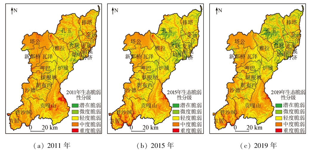
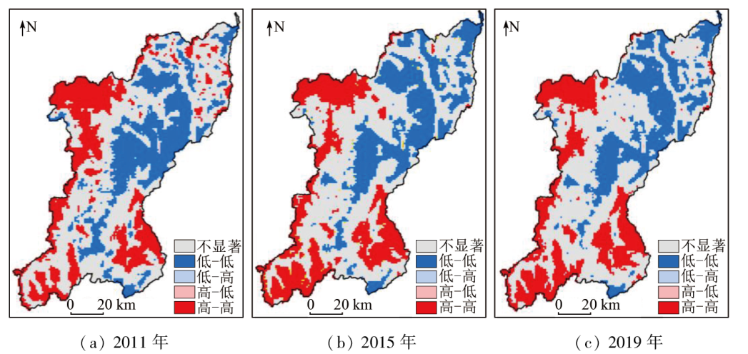
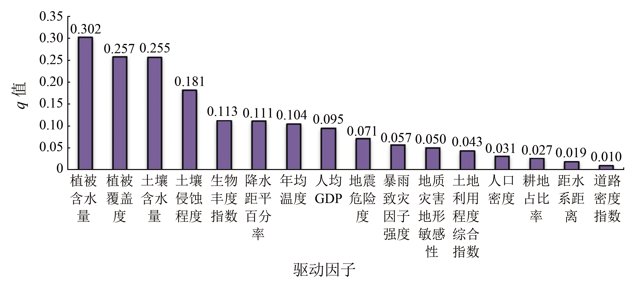
Abstract This study constructed an assessment index system for ecological vulnerability based on the vulnerability scoping diagram (VSD) model. It dynamically assessed the three-phase ecological vulnerability of Kangding City from 2011 to 2019 using the analytic hierarchy process - principal component analysis - entropy weight method (AHP-PCA-EWM). Through the analysis of spatio-temporal variations, spatial correlations, and driving factors, it revealed the spatio-temporal differentiation characteristics and driving mechanism of Kangding’s ecological vulnerability, aiming to provide suggestions for the ecological restoration, conservation, and sustainable development of Kangding. The results of this study are as follows: ① Throughout the study period, Kangding exhibited an overall moderate ecological vulnerability, with increased potentially- and slightly-vulnerable areas and a decreased severely vulnerable area, suggesting a promising ecological evolutionary trend. Moreover, the ecological vulnerability of Kangding manifested spatial distributions characterized by high-high clusters in the western and southeastern portions and low-low clusters in the northeastern and middle portion; ② The spatial distributions of ecological vulnerability in Kangding were subjected to various internal and external factors, with natural driving factors like vegetation cover, biological abundance, soil and water conservation, and meteorology being the dominant ones.
|
| Keywords
ecological vulnerability
AHP-PCA-EWM
Moran’s I
geodetector
Kangding City
|
|
|
|
Issue Date: 03 September 2024
|
|
|
| [1] |
田亚平, 常昊. 中国生态脆弱性研究进展的文献计量分析[J]. 地理学报, 2012, 67(11):1515-1525.
|
| [1] |
Tian Y P, Chang H. Bibliometric analysis of research progress on ecological vulnerability in China[J]. Acta Geographica Sinica, 2012, 67(11):1515-1525.
doi: 10.11821/xb201211008
|
| [2] |
杨飞, 马超, 方华军. 脆弱性研究进展:从理论研究到综合实践[J]. 生态学报, 2019, 39(2):441-453.
|
| [2] |
Yang F, Ma C, Fang H J. Research progress on vulnerability:From theoretical research to comprehensive[J]. Acta Ecologica Sinica, 2019, 39(2):441-453.
|
| [3] |
杨紫薇, 张慢真, 邢勤锋. 我国近三十年生态脆弱性的发展态势研究[J]. 黑河学院学报, 2022, 13(6):184-188.
|
| [3] |
Yang Z W, Zhang M Z, Xing Q F. On the development trend of ecological vulnerability in recent thirty years[J]. Journal of Heihe University, 2022, 13(6):184-188.
|
| [4] |
姚建, 艾南山, 丁晶. 中国生态环境脆弱性及其评价研究进展[J]. 兰州大学学报, 2003(3):77-80.
|
| [4] |
Yao J, Ai N S, Ding J. Progress in the studies of eco-environmental fragility and assessment in China[J]. Journal of Lanzhou University(Natural Sciences), 2003(3):77-80.
|
| [5] |
赵银兵, 倪忠云, 欧阳渊, 等. 生态地质环境承载力研究进展[J]. 沉积与特提斯地质, 2022, 42(4):529-541.
|
| [5] |
Zhao Y B, Ni Z Y, Ouyang Y, et al. Research progress of eco-geological environment carrying capacity[J]. Sedimentary Geology and Tethyan Geology, 2022, 42(4):529-541.
|
| [6] |
刘洪, 黄瀚霄, 欧阳渊, 等. 基于地质建造的土壤地质调查及应用前景分析——以大凉山区西昌市为例[J]. 沉积与特提斯地质, 2020, 40(1):91-105.
|
| [6] |
Liu H, Huang H X, Ouyang Y, et al. Soil’s geologic investigation in Daliangshan,Xichang,Sichuan[J]. Sedimentary Geology and Tethyan Geology, 2020, 40(1):91-105.
|
| [7] |
张连凯, 覃小群, 黄奇波, 等. 岩溶区矿山污染地下水的水生植物修复初步研究[J]. 中国岩溶, 2017, 36(5):743-750.
|
| [7] |
Zhang L K, Qin X Q, Huang Q B, et al. Aquatic plants bioremediation to groundwater contaminated by mines in karst areas[J]. Carsologica Sinica, 2017, 36(5):743-750.
|
| [8] |
徐洲洋. 基于PSR模型的四川生态系统健康时空动态研究[J]. 国土资源遥感, 2020, 32(2):251-258.doi:10.6046/gtzyyg.2020.02.32.
|
| [8] |
Xu Z Y. Spatial-temporal dynamics of ecosystem health in Sichuan Province based on PSR model[J]. Remote Sensing for Land and Resources, 2020, 32(2):251-258.doi:10.6046/gtzyyg.2020.02.32.
|
| [9] |
Polsky C, Neff R, Yarnal B. Building comparable global change vulnerability assessments:The vulnerability scoping diagram[J]. Global Environmental Change-Human and Policy Dimensions, 2007, 17(3/4):472-485.
|
| [10] |
马丽丽, 田淑芳, 王娜. 基于层次分析与模糊数学综合评判法的矿区生态环境评价[J]. 国土资源遥感, 2013, 25(3):165-170.doi:10.6046/gtzyyg.2013.03.27.
|
| [10] |
Ma L L, Tian S F, Wang N. Ecological environment evaluation of the mining area based on AHP and fuzzy mathematics[J]. Remote Sensing for Land and Resources, 2013, 25(3):165-170.doi:10.6046/gtzyyg.2013.03.27.
|
| [11] |
潘佩芬, 杨武年, 戴晓爱. 基于主成分分析的植被含水率模型[J]. 国土资源遥感, 2013, 25(3):38-42.doi:10.6046/gtzyyg.2013.03.07.
|
| [11] |
Pan P F, Yang W N, Dai X A. Vegetation moisture content model based on principal component analysis[J]. Remote Sensing for Land and Resources, 2013, 25(3):38-42.doi:10.6046/gtzyyg.2013.03.07.
|
| [12] |
邵秋芳, 彭培好, 黄洁, 等. 长江上游安宁河流域生态环境脆弱性遥感监测[J]. 国土资源遥感, 2016, 28(2):175-181.doi:10.6046/gtzyyg.2016.02.27.
|
| [12] |
Shao Q F, Peng P H, Huang J, et al. Monitoring eco-environmental vulnerability in Anning River Basin in the upper reaches of the Yangtze River using remote sensing techniques[J]. Remote Sensing for Land and Resources, 2016, 28(2):175-181.doi:10.6046/gtzyyg.2016.02.27.
|
| [13] |
林雪敏, 李伟峰, 王红, 等. 我国东部沿海三大城市群地下水储量变化与驱动因素分析[J]. 自然资源遥感, 2022, 34(4):262-271.doi:10.6046/zrzyyg.2022007.
|
| [13] |
Lin X M, Li W F, Wang H, et al. Analysis of the groundwater storage variations and their driving factors in the three eastern coastal urban agglomerations of China[J]. Remote Sensing for Natural Resources, 2022, 34(4):262-271.doi:10.6046/zrzyyg.2022007.
|
| [14] |
姚昆, 张存杰, 何磊, 等. 雅砻江中上游流域生态环境脆弱性动态评价及预测[J]. 国土资源遥感, 2020, 32(4):199-208.doi:10.6046/gtzyyg.2020.04.25.
|
| [14] |
Yao K, Zhang C J, He L, et al. Dynamic evaluation and prediction of ecological environment vulnerability in the middle-upper reaches of the Yalong River[J]. Remote Sensing for Land and Resources, 2020, 32(4):199-208.doi:10.6046/gtzyyg.2020.04.25.
|
| [15] |
周梦云. 干旱半干旱区山地生态系统脆弱性评估方法体系与实例研究[D]. 上海: 华东师范大学, 2017.
|
| [15] |
Zhou M Y. The method system and case study of a vulnerability assessment of mountain ecological system in semi-arid and arid areas[D]. Shanghai: East China Normal University, 2017.
|
| [16] |
郑万模, 巴仁基, 刘宇杰, 等. 四川康定城市地震地质及地质灾害风险评价[J]. 沉积与特提斯地质, 2012, 32(3):75-78.
|
| [16] |
Zheng W M, Ba R J, Liu Y J, et al. Risk evaluation of urban seismogeology and geological hazards in Kangding,western Sichuan[J]. Sedimentary Geology and Tethyan Geology, 2012, 32(3):75-78.
|
| [17] |
李海龙. 基于最小累积阻力模型的川西高原绿道游径系统线路规划方法研究——以康定市为例[J]. 城市发展研究, 2018, 25(11):58-64.
|
| [17] |
Li H L. Western sichuan plateau greenway trails system planning method based on MCR model[J]. Urban Development Studies, 2018, 25(11):58-64.
|
| [18] |
贾佳, 白军红, 邓伟, 等. 近20年来康定市景观格局演变及其驱动力分析[J]. 安全与环境学报, 2017, 17(4):1571-1577.
|
| [18] |
Jia J, Bai J H, Deng W, et al. On the landscape pattern evolution and its motivating factors in Kangding City in the past two decades[J]. Journal of Safety and Environment, 2017, 17(4):1571-1577.
|
| [19] |
周昭琼, 张子瑜. 康定县退化草地空间分布与治理对策浅析[J]. 四川林业科技, 2015, 36(3):55-61.
|
| [19] |
Zhou Z Q, Zhang Z Y. Analysis of spatial distribution and management measures of degraded grassland in Kangding County[J]. Journal of Sichuan Forestry Science and Technology, 2015, 36(3):55-61.
|
| [20] |
张文朋. 基于AHP-FUZZY的地震危险度评价初探[J]. 华北地震科学, 2018, 36(4):63-72.
|
| [20] |
Zhang W P. Study on Seismic hazard assessment based on AHP-FUZZY method[J]. North China Earthquake Sciences, 2018, 36(4):63-72.
|
| [21] |
樊高峰, 何月, 顾骏强. 基于GIS的浙江省暴雨灾害及其危险性评价[J]. 中国农学通报, 2012, 28(32):293-299.
|
| [21] |
Fan G F, He Y, Gu J Q. The rainstorm disaster and its risk assessment based on GIS in Zhejiang Province[J]. Chinese Agricultural Science Bulletin, 2012, 28(32):293-299.
doi: 10.11924/j.issn.1000-6850.2012-1273
|
| [22] |
黄润秋, 李为乐. 汶川地震触发崩塌滑坡数量及其密度特征分析[J]. 地质灾害与环境保护, 2009, 20(3):1-7.
|
| [22] |
Huang R Q, Li W L. Analysis of the number and density of landslides triggered by the 2008 Wenchuan earthquake,China[J]. Journal of Geological Hazards and Environment Preservation, 2009, 20(3):1-7.
|
| [23] |
向明顺. 地震重灾区生态环境遥感动态监测与评价研究[D]. 成都: 成都理工大学, 2018.
|
| [23] |
Xiang M S. Rremote sensing based on dynamic monitoring and evaluation of Eco-environmental change in earthquake-striken areas—a case study in Beichuan county,Sichuan Province,China[D]. Chengdu: Chengdu University of Technology, 2018.
|
| [24] |
罗新蕊. 岷江上游茂县植被冠层生态水遥感定量反演[D]. 成都: 成都理工大学, 2019.
|
| [24] |
Luo X R. Quantifying vegetation canopy eco-water using remote sensing in Maoxian,upper reaches of Mingjiang river[D]. Chengdu: Chengdu University of Technology, 2019.
|
| [25] |
张连凯, 杨慧. 岩溶地下河中砷迁移过程及其影响因素分析——以广西南丹县里湖地下河为例[J]. 中国岩溶, 2013, 32(4):377-383.
|
| [25] |
Zhang L K, Yang H. Transport process of arsenic in karst subterranean stream and analysis on the influence factors:A case in Lihu subterranean stream of Nandan County,Guangxi[J]. Carsologica Sinica, 2013, 32(4):377-383.
|
| [26] |
张景华, 张建龙, 欧阳渊, 等. 基于形成机理的石漠化敏感性评价:以贵州省黔西县为例[J]. 沉积与特提斯地质, 2024, 44(1):162-171.
|
| [26] |
Zhang J H, Zhang J L, Ouyang Y, et al. Sensitivity evaluation of Karst rock desertification based on its formation mechanism:A case study of Qianxi County in Guizhou Province[J]. Sedimentary Geology and Tethyan Geology, 2024, 44(1):162-171.
|
| [27] |
刘浩, 周万蓬, 张宇佳, 等. 基于Landsat影像的1999—2019年鄱阳湖面积动态监测[J]. 东华理工大学学报(自然科学版), 2023, 46(1):68-76.
|
| [27] |
Liu H, Zhou W P, Zhang Y J, et al. Dynamic monitoring of area in Poyang Lake from 1999 to 2019 based on landsat images[J]. Journal of East China University of Technology (Natural Science), 2023, 46(1):68-76.
|
| [28] |
李富, 欧阳渊, 刘洪, 等. 高密度电阻率法与地质雷达法在土壤厚度调查中应用效果——以西昌市土壤厚度调查为例[J]. 华北地质, 2021, 44(1):27-32,38.
|
| [28] |
Li F, Ouyang Y, Liu H, et al. Application of high density resistivity and geological radar in soil thickness survey:A case study of the soil thickness survey in Xichang[J]. North China Geology, 2021, 44(1):27-32,38.
|
| [29] |
杨武年, 简季, 李玉霞, 等. 生态水遥感定量研究[J]. 成都理工大学学报(自然科学版), 2008, 147(2):219.
|
| [29] |
Yang W N, Jian J, Li Y X, et al. Research on remote sensing quantitative of eco-water[J]Journal of Chengdu University of Technology(Science and Technology Edition), 2008, 147(2):219.
|
| [30] |
万新南, 杨武年, 吴炳方, 等. “生态水层与生态水”概念及研究意义[J]. 地球科学进展, 2004(s1):117-121.
|
| [30] |
Wan X N, Yang W N, Wu B F, et al. Conception of eco-water sphere and its application[J]. Advance in Earth Sciences, 2004(s1):117-121.
|
| [31] |
黄瑾. 岷江上游生态水遥感定量反演及径流预测模型研究[D]. 成都: 成都理工大学, 2016.
|
| [31] |
Huang J. Research on remote sening quantitative retrieved eco-water driven runoff forecasting model for the upper reaches of Minjiang River[D]. Chengdu: Chengdu University of Technology, 2016.
|
| [32] |
陈宗杰, 杨武年, 张琬琳, 等. 基于植被冠层含水量反演数据的森林易燃程度评价[J]. 测绘通报, 2023(4):99-105.
doi: 10.13474/j.cnki.11-2246.2023.0111
|
| [32] |
Chen Z J, Yang W N, Zhang W L, et al. Evaluation of forest flammability based on inversion data of vegetation canopy water content[J]. Bulletin of Surveying and Mapping, 2023(4):99-105.
doi: 10.13474/j.cnki.11-2246.2023.0111
|
| [33] |
潘佩芬. 植被生态水涵养模数遥感反演及生态水资源量计算——以岷江上游毛尔盖地区为例[D]. 成都: 成都理工大学, 2014.
|
| [33] |
Pan P F. Remote sensing retriveral about conservation modulus of vegetation eco-water and calculation of eco-water resource quantity:A case study of Maoergai area in upper Minjiang River[D]. Chengdu: Chengdu University of Technology, 2014.
|
| [34] |
陈超. 九寨沟县震后潜在泥石流危险性评价研究[D]. 成都: 成都理工大学, 2019.
|
| [34] |
Chen C. Risk assessment of potential debris flow after earthquake in Jiuzhaigou County,Aba Prefecture,Sichuan Province[D]. Chengdu: Chengdu University of Technology, 2019.
|
| [35] |
张景华, 欧阳渊, 刘洪, 等. 基于主控要素的生态地质脆弱性评价——以四川省西昌市为例[J]. 自然资源遥感, 2021, 33(4):181-191.
|
| [35] |
Zhang J H, Ouyang Y, Liu H, et al. Eco-geological vulnerability assessment based on major controlling factors:A case study of Xichang City,Sichuan Province[J]. Remote Sensing for Natural Resources, 2021, 33(4):181-191.
|
| [36] |
林海明, 杜子芳. 主成分分析综合评价应该注意的问题[J]. 统计研究, 2013, 30(8):25-31.
|
| [36] |
Lin H M, Du Z F. Some problems in comprehensive evaluation in the principal component analysis[J]. Statistical Research, 2013, 30(8):25-31.
|
| [37] |
陈朝亮, 彭树宏, 钱静, 等. 基于AHP-Logistic熵权模型的西南浅丘区地质灾害分布特征研究——以内江市为例[J]. 长江科学院院报, 2020, 37(2):55-61.
doi: 10.11988/ckyyb.20181136
|
| [37] |
Chen C L, Peng S H,Qian,J, et al. Distribution characteristics of geological hazards in southwestern shallow hill based on AHP-Logistic entropy combined weight model:A case study of Neijiang City[J]. Journal of Yangtze River Scientific Research Institute, 2020, 37(2):55-61.
|
| [38] |
于国强, 杜保佳, 刘吉平. 1986—2012年吉林省西部湿地生态系统脆弱性评价[J]. 湿地科学, 2016, 14(3):439-445.
|
| [38] |
Yu G Q, Du B J, Liu J P. Ecosystem vulnerability assessment of wetlands in western Jilin Province from 1986 to 2012[J]. Wetland Science, 2016, 14(3):439-445.
|
| [39] |
汪邦稳, 汤崇军, 杨洁, 等. 基于水土流失的江西省生态安全评价[J]. 中国水土保持科学, 2010, 8(1):51-57.
|
| [39] |
Wang B W, Tang C J, Yang J, et al. Ecological security assessment of Jiangxi Province based on soil erosion and water loss[J]. Science of Soil and Water Conservation, 2010, 8(1):51-57.
|
| [40] |
茹少峰, 马茹慧. 黄河流域生态环境脆弱性评价、空间分析及预测[J]. 自然资源学报, 2022, 37(7):1722-1734.
doi: 10.31497/zrzyxb.20220705
|
| [40] |
Ru S F, Ma R H. Evaluation,spatial analysis and prediction of ecological vulnerability in the Yellow River basin[J]. Journal of Natural Resources, 2022, 37(7):1722-1734.
|
| [41] |
孙一可, 宫辉力, 陈蓓蓓, 等. 综合莫兰指数和交叉小波的不均匀沉降量化分析[J]. 国土资源遥感, 2020, 32(2):186-195.doi:10.6046/gtzyyg.2020.02.24.
|
| [41] |
Sun Y K, Gong H L, Chen B B, et al. Quantitative analysis of uneven subsidence by Moran’s I and cross wavelet[J]. Remote Sensing for Land and Resources, 2020, 32(2):186-195.doi:10.6046/gtzyyg.2020.02.24.
|
| [42] |
王劲峰, 徐成东. 地理探测器:原理与展望[J]. 地理学报, 2017, 72(1):116-134.
doi: 10.11821/dlxb201701010
|
| [42] |
Wang J F, Xu C D. Geodetectors:Principles and prospects[J]. Acta Geographica Sinica, 2017, 72(1):116-134.
|
|
Viewed |
|
|
|
Full text
|
|
|
|
|
Abstract
|
|
|
|
|
Cited |
|
|
|
|
| |
Shared |
|
|
|
|
| |
Discussed |
|
|
|
|
 2024,
Vol. 36
2024,
Vol. 36