|
|
 |
|

|
|
|
Identification and assessment of small landslides in densely vegetated areas based on airborne LiDAR technique |
CHEN Gang1( ), HAO Shefeng1, JIANG Bo1, YU Yongxiang1, CHE Zengguang1, LIU Hanhu2(), YANG Ronghao2 ), HAO Shefeng1, JIANG Bo1, YU Yongxiang1, CHE Zengguang1, LIU Hanhu2(), YANG Ronghao2 |
1. Geological Survey of Jiangsu Province, Nanjing 210018, China
2. College of Earth Sciences, Chengdu University of Technology, Chengdu 610059, China |
|
|
|
|
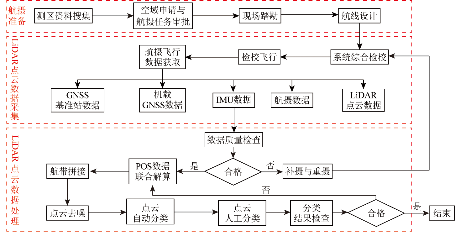
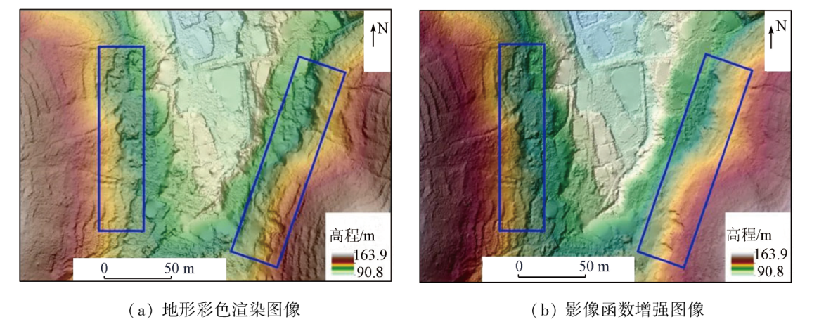
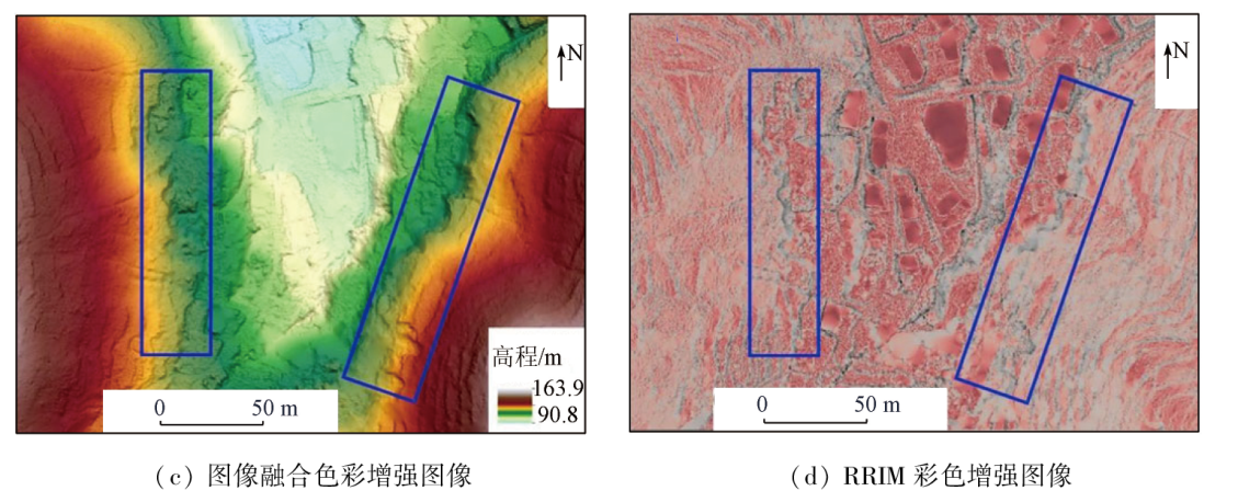
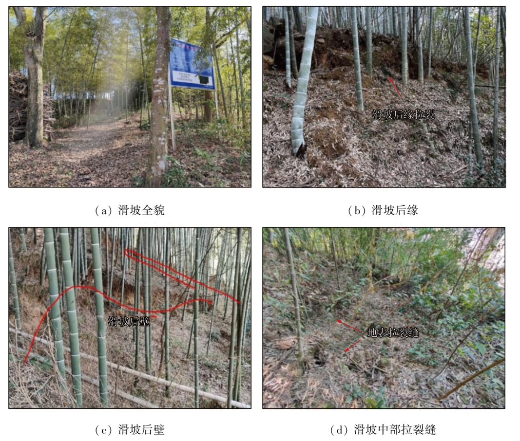
Abstract Landslides may cause the loss of lives and property, and an accurate and complete map showing the spatial distribution of landslides and the determination of landslide susceptibility areas assist in guiding the optimization of the production, living, and ecological spaces. However, landslide investigations are complicated by dense vegetation. LiDAR technology enables the presentation of actual terrain features, thereby achieving landslide identification in densely vegetated areas. This study obtained the LiDAR point cloud data of the study area through ground-imitating flight and then built a digital elevation model (DEM) through data processing. Then, based on mountain shadow analysis, color-enhanced presentation, and 3D scene simulation, the locations and scales of existing landslides in the study area were identified. The field verification revealed an interpretation accuracy of landslides of up to 86.4%. For the assessment of landslide susceptibility areas, this study, with existing landslides as samples, delineated landslide susceptibility areas through remote sensing classification for the first time. Specifically, images were synthesized using the landslide-related elevations, slopes, and surface undulations, and then landslide susceptibility areas were determined using the support vector machine (SVM) classification method. The analysis of the inspection samples reveals a landslide identification accuracy of 81.91%. The results show that the image identification based on high-accuracy LiDAR data and visually enhanced images allows for the delineation of small landslides and that the SVM classification method enables the accurate location of landslide susceptibility areas. This study provides a basis for the future planning and optimization of the production, living, and ecological spaces.
|
| Keywords
LiDAR
landslide
mountain shadow
SVM
landslide susceptibility area
|
|
|
|
Issue Date: 03 September 2024
|
|
|
| [1] |
张勤, 赵超英, 陈雪蓉. 多源遥感地质灾害早期识别技术进展与发展趋势[J]. 测绘学报, 2022, 51(6):885-896.
doi: 10.11947/j.AGCS.2022.20220132
|
| [1] |
Zhang Q, Zhao C Y, Chen X R. Technical progress and development trend of geological hazards early identification with multi-source remote sensing[J]. Acta Geodaetica et Cartographica Sinica, 2022, 51(6):885-896.
doi: 10.11947/j.AGCS.2022.20220132
|
| [2] |
杨长江, 易祎, 赵蓉. 基于Sentinel-1数据的时序InSAR技术在滑坡监测方面的应用——以巴东地区为例[J]. 科技创新与生产力, 2017, 279(4):55-58,63.
|
| [2] |
Yang C J, Yi Y, Zhao R. Monitoring landslide movements using time series InSAR with sentinel-1:Application to Badong area[J]. Sci-Tech Innovation and Productivity, 2017, 279(4):55-58,63.
|
| [3] |
李显巨. 基于LiDAR技术的复杂地质环境区滑坡识别研究[D]. 武汉: 中国地质大学, 2012.
|
| [3] |
Li X J. Research of the landslide recognition based on LiDAR technology in the complex geological environment area master candidate[D]. Wuhan: China University of Geosciences, 2012.
|
| [4] |
许强, 董秀军, 李为乐. 基于天-空-地一体化的重大地质灾害隐患早期识别与监测预警[J]. 武汉大学学报(信息科学版), 2019, 44(7):957-966.
|
| [4] |
Xu Q, Dong X J, Li W L. Integrated space-air-ground early detection,monitoring and warning system for potential catastrophic geohazards[J]. Geomatics and Information Science of Wuhan University, 2019, 44(7):957-966.
|
| [5] |
董秀军, 许强, 佘金星, 等. 九寨沟核心景区多源遥感数据地质灾害解译初探[J]. 武汉大学学报(信息科学版), 2020, 45(3):432-441.
|
| [5] |
Dong X J, Xu Q, She J X, et al. Preliminary study on interpretation of geological hazards in Jiuzhaigou based on multi-source remote sensing data[J]. Geomatics and Information Science of Wuhan University, 2020, 45(3):432-441.
|
| [6] |
Chigira M, Duan F, Yagi H, et al. Using an airborne laser scanner for the identification of shallow landslides and susceptibility assessment in an area of ignimbrite overlain by permeable pyroclastics[J]. Landslides, 2004, 1(3):203-209.
|
| [7] |
Haneberg W C, Creighton A L, Medley E W, et al. Use of LiDAR to assess slope hazards at the Lihir gold mine,Papua New Guinea[C]// International Conference on Landslide Risk Management,Vancouver,British Columbia, 2005:1-10.
|
| [8] |
Razak K A, Santangelo M, Van Westen C J, et al. Generating an optimal DTM from airborne laser scanning data for landslide mapping in a tropical forest environment[J]. Geomorphology, 2013, 190:112-125.
|
| [9] |
Ju L Y, Zhang L M, Xiao T. Power laws for accurate determination of landslide volume based on high-resolution LiDAR data[J]. Engineering Geology, 2023, 312:106935.
|
| [10] |
邵延秀, 张波, 邹小波, 等. 采用无人机载LiDAR进行快速地质调查实践[J]. 地震地质, 2017, 39(6):1185-1197.
doi: 10.3969/j.issn.0253-4967.2017.06.007
|
| [10] |
Shao Y X, Zhang B, Zou X B, et al. Application of UAVLS to rapid geological surveys[J]. Seismology and Geology, 2017, 39(6):1185-1197.
|
| [11] |
王绚, 范宣梅, 杨帆, 等. 植被茂密山区地质灾害遥感解译方法研究[J]. 武汉大学学报(信息科学版), 2020, 45(11):1771-1781.
|
| [11] |
Wang X, Fan X M, Yang F, et al. Remote sensing interpretation method of geological hazards in lush mountainous area[J]. Geomatics and Information Science of Wuhan University, 2020, 45(11):1771-1781.
|
| [12] |
佘金星, 许强, 杨武年, 等. 九寨沟地震地质灾害隐患早期识别与分析研究[J]. 工程地质学报, 2023, 31(1):207-216.
|
| [12] |
She J X, Xu Q, Yang W N, et al. Early identification and analysis of earthquake and geological hazards in Jiuzhaigou[J]. Journal of Engineering Geology, 2023, 31(1):207-216.
|
| [13] |
彭艺伟, 董琦, 田冲, 等. 基于机载激光雷达的地质灾害识别关键技术及应用研究[J]. 安全与环境工程, 2021, 28(6):100-108.
|
| [13] |
Peng Y W, Dong Q, Tian C, et al. Research on key technologies and application of geological hazard identification based on airborne LiDAR[J]. Safety and Environmental Engineering, 2021, 28(6):100-108.
|
| [14] |
郭晨, 许强, 董秀军, 等. 复杂山区地质灾害机载激光雷达识别研究[J]. 武汉大学学报(信息科学版), 2021, 46(10):1538-1547.
|
| [14] |
Guo C, Xu Q, Dong X J, et al. Geohazard recognition by airborne LiDAR technology in complex mountain areas[J]. Geomatics and Information Science of Wuhan University, 2021, 46(10):1538-1547.
|
| [15] |
邓博, 张会, 柏君, 等. 利用机载LiDAR的深圳斜坡类地质灾害危险性评价[J/OL]. 武汉大学学报(信息科学版):1-18 [2023-03-01].https://doi.org/10.13203/j.whugis20220141.
url: https://doi.org/10.13203/j.whugis20220141
|
| [15] |
Deng B, Zhang H, Bai J, et al. Hazard evaluation of the slope in Shenzhen based on airborne LiDAR data[J/OL]. Geomatics and Information Science of Wuhan University:1-18 [2023-03-01].https://doi.org/10.13203/j.whugis20220141.
url: https://doi.org/10.13203/j.whugis20220141
|
| [16] |
Mark R K. A multidirectional,oblique-weighted,shaded-relief image of the island of Hawaii[R] Open-file Report, 1992.
|
| [17] |
Chiba T, Kaneta S, Suzuki Y. Red relief image map: New visualization method for three dimensional data[J]. The International Archives of the Photogrammetry,Remote Sensing and Spatial Information Sciences, 2008, 37(b2): 1071-1076
|
| [18] |
王涛, 吴树仁, 石菊松. 国际滑坡风险评估与管理指南研究综述[J]. 地质通报, 2009, 28(8):1006-1019.
|
| [18] |
Wang T, Wu S R, Shi J S. A review of international landslide risk assessment and management guidelines[J]. Geological Bulletin of China, 2009, 28(8):1006-1019.
|
| [19] |
邹富宝, 付卓, 樊风雷, 等. 基于频率比与AHP模型的西藏东部地区滑坡易发性评价[J]. 自然灾害学报, 2023, 32(2):235-242.
|
| [19] |
Zou F B, Fu Z, Fan F L, et al. Evaluation of landslide susceptibility in eastern Tibet based on frequency ratio and AHP model[J]. Journal of Natural Disasters. 2023, 32(2):235-242.
|
| [20] |
刘纪平, 梁恩婕, 徐胜华, 等. 顾及样本优化选择的多核支持向量机滑坡灾害易发性分析评价[J]. 测绘学报, 2022, 51(10):2034-2045.
doi: 10.11947/j.AGCS.2022.20220326
|
| [20] |
Liu J P, Liang E J, Xu S H, et al. Multi-kernel support vector machine considering sample optimization selection for analysis and evaluation of landslide disaster susceptibility[J]. Acta Geodaetica et Cartographica Sinica, 2022, 51(10):2034-2045.
doi: 10.11947/j.AGCS.2022.20220326
|
| [21] |
张玺国, 周雄冬, 徐梦珍, 等. 西藏地质灾害易发性及对水能开发适宜度影响[J]. 地理学报, 2022, 77(7):1603-1614.
doi: 10.11821/dlxb202207003
|
| [21] |
Zhang X G, Zhou X D, Xu M Z, et al. Distribution of hydropower development suitability in Tibet in the face of geological hazard susceptibility[J]. Acta Geographica Sinica, 2022, 77(7):1603-1614.
doi: 10.11821/dlxb202207003
|
| [22] |
成淑艳, 曹生奎, 曹广超, 等. 基于高分辨率遥感影像的青海湖沙柳河流域土地覆盖监督分类方法对比[J]. 水土保持通报, 2018, 38(5):261-268,353.
|
| [22] |
Cheng S Y, Cao S K, Cao G C, et al. Comparisons of supervised classification methods for land cover based on high spatial resolution remote sensing images in Shaliu River basin of Qinghai Lake[J]. Bulletin of Soil and Water Conservation, 2018, 38(5):261-268,353.
|
| [23] |
李鹏, 蒋宁桑, 封志明, 等. 基于支持向量机的老挝丰沙里省新开辟刀耕火种遥感监测及其空间特征[J]. 遥感学报, 2022, 26(11):2329-2343.
|
| [23] |
Li P, Jiang N S, Feng Z M, et al. Freshly-opened swidden mapping using support vector machine (SVM)and spatial characteristics in Phongsaly Province,Laos[J]. National Remote Sensing Bulletin, 2022, 26(11): 2329-2343.
|
| [24] |
Cortes C, Vapnik V. Support-vector networks[J]. Machine Learning, 1995, 20(3):273-297.
|
| [25] |
薛永安, 邹友峰, 张文志, 等. 基于SVM的地下采煤区沉陷灾害发育敏感性分区研究[J]. 煤田地质与勘探, 2022, 50(10):108-118.
|
| [25] |
Xue Y A, Zou Y F, Zhang W Z, et al. SVM-based sensitivity zoning of subsidence disaster development in the underground coal mining areas[J]. Coal Geology and Exploration, 2022, 50(10): 108-118.
|
| [26] |
童立强, 郭兆成. 典型滑坡遥感影像特征研究[J]. 国土资源遥感, 2013, 25(1):86-92.doi: 10.6046/gtzyyg.2013.01.16.
|
| [26] |
Tong L Q, Guo Z C. A study of remote sensing image features of typical landslides[J]. Remote Sensing for Land and Resources, 2013, 25(1):86-92.doi: 10.6046/gtzyyg.2013.01.16.
|
|
Viewed |
|
|
|
Full text
|
|
|
|
|
Abstract
|
|
|
|
|
Cited |
|
|
|
|
| |
Shared |
|
|
|
|
| |
Discussed |
|
|
|
|
 2024,
Vol. 36
2024,
Vol. 36