|
|
 |
|

|
|
|
Ecological vulnerability assessment of the Yellow River basin based on partition-integration concept |
YANG Wenna1,2( ), ZHOU Liang1,3,4(), SUN Dongqi3 ), ZHOU Liang1,3,4(), SUN Dongqi3 |
1. Faculty of Geomatics, Lanzhou Jiaotong University, Lanzhou 730070, China
2. National-Local Joint Engineering Research Center of Technologies and Applications for National Geographic State Monitoring, Lanzhou 730070, China
3. Institute of Geographic Sciences and Natural Resources Research/State Key Laboratory of Resources and Environment Information System, Beijing 100101, China
4. Gansu Provincial Engineering Laboratory for National Geographic State Monitoring, Lanzhou 730070, China |
|
|
|
|
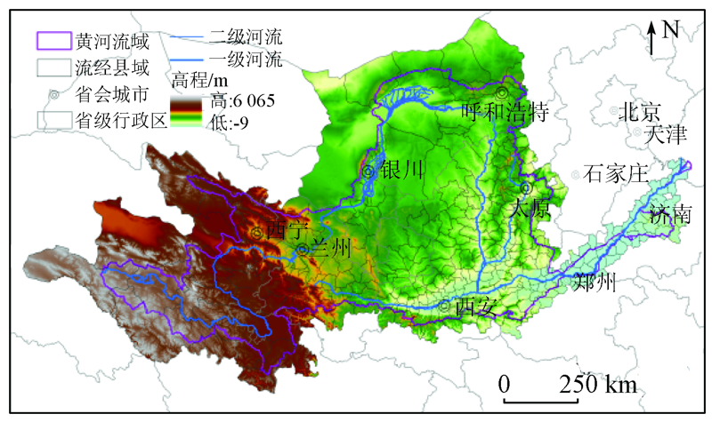
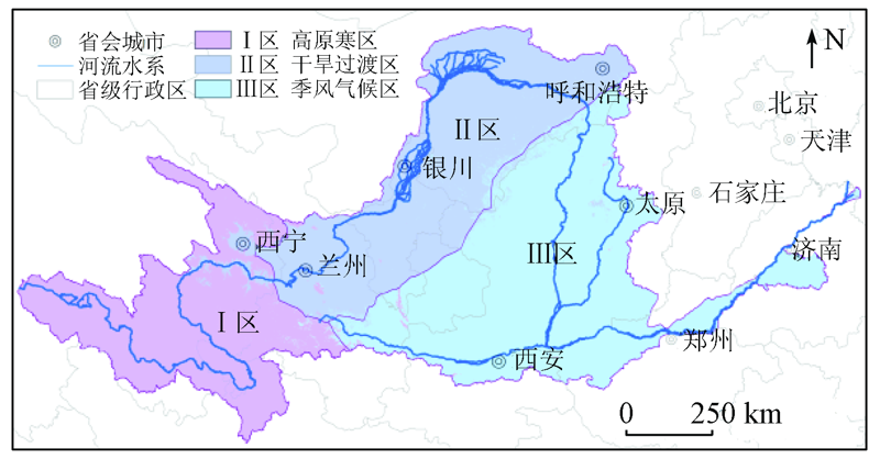
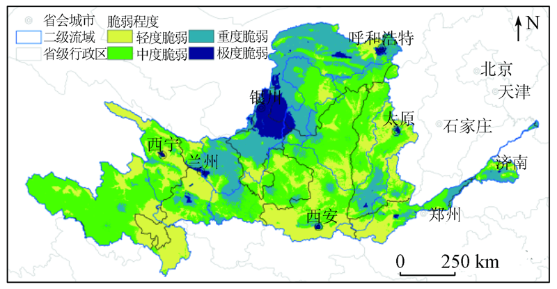
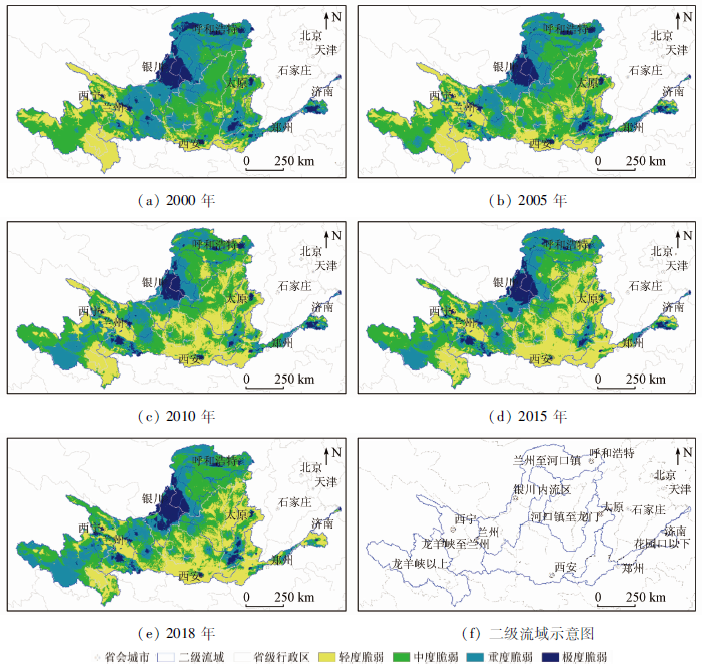
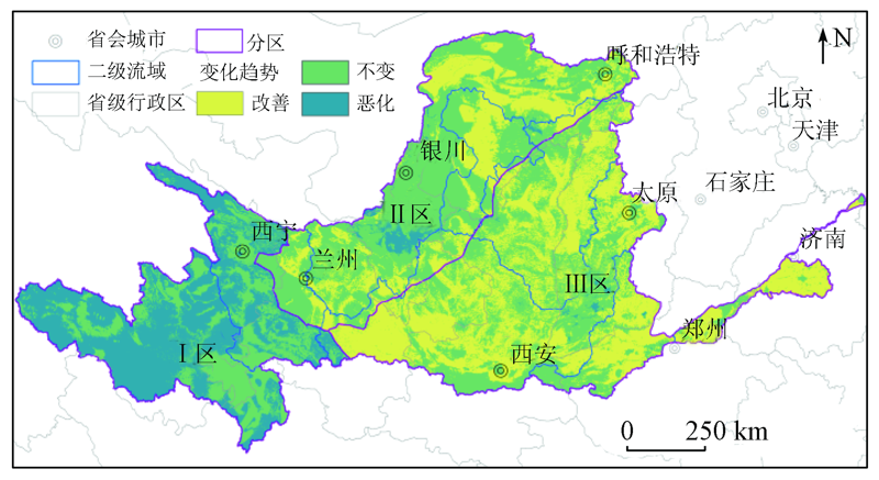
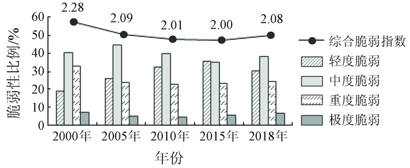
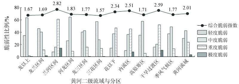
Abstract The Yellow River basin is an important ecological safety barrier, an agglomeration area of resource and energy, and an area with highly intensive production activities in China. Therefore, its ecological change directly affects the sustainable development of the ecological environment and economy in the basin. This paper aims to quantitatively assess the ecological vulnerability and analyze the spatial heterogeneity in the Yellow River basin. To this end, an evaluation system was established using the partition-integration assessment method by selecting indicators such as water resources, climate, soil, vegetation, and human activities. Meanwhile, a multiplication model was introduced. The assessment results are as follows. The overall ecological environment in the basin is moderately vulnerable, with moderately vulnerable areas accounting for 42.37% of the total area of the basin. Meanwhile, the areas with a highly vulnerable ecological environment in the basin are mainly distributed in the urban economic belt along the upper mainstream of the Yellow River. From 2000 to 2018, the ecological vulnerability of the basin first decreased and then increased. During this period, ecological problems were the most notable in 2000 and ecological vulnerability was the lowest in 2015, with the Comprehensive Vulnerability Index (CVI) of 2.28 and 2.00, respectively in 2000 and 2015. The ecological vulnerability and its evolution trend in the basin significantly varied in space. In detail, the ecological vulnerability notably increased in the plateau areas in the upper reaches, slightly changed in the urban belt along the river, and significantly decreased in the middle and lower reaches.
|
| Keywords
partition-integration
ecological vulnerability
spatial difference
sustainable development
Yellow River basin
|
|
|
|
Corresponding Authors:
ZHOU Liang
E-mail: yangwennaleo10@163.com;zhougeo@126.com
|
|
Issue Date: 24 September 2021
|
|
|
| [1] |
罗跃初, 周忠轩, 孙轶, 等. 流域生态系统健康评价方法[J]. 生态学报, 2003, 23(8):1606-1614.
|
| [1] |
Luo Y C, Zhou Z X, Sun Y, et al. Assessment methods of watershed ecosystem health[J]. Acta Ecologica Sinica, 2003, 23(8):1606-1614.
|
| [2] |
Zhang F, Liu X P, Zhang J Q, et al. Ecological vulnerability assessment based on multi-sources data and SD model in Yinma River Basin,China[J]. Ecological Modelling, 2017, 349(7):41-50.
doi: 10.1016/j.ecolmodel.2017.01.016
url: https://linkinghub.elsevier.com/retrieve/pii/S0304380016304975
|
| [3] |
Zhou L, Xu J G, Sun D Q. Zoning assessment of water environmental supporting capacity of socioeconomic development in the Huaihe River Basin,China[J]. Journal of Geographical Sciences, 2015, 25(10):1199-1217.
doi: 10.1007/s11442-015-1228-1
url: http://link.springer.com/10.1007/s11442-015-1228-1
|
| [4] |
Beroya-Eitner M A. Ecological vulnerability indicators[J]. Ecological Indicators, 2016, 60(1):329-334.
doi: 10.1016/j.ecolind.2015.07.001
url: https://linkinghub.elsevier.com/retrieve/pii/S1470160X15003738
|
| [5] |
Ahn S R, Kim S J. Assessment of integrated watershed health based on the natural environment,hydrology,water quality,and aquatic ecology[J]. Hydrology and Earth System Science, 2017, 21(11):5583-5602.
doi: 10.5194/hess-21-5583-2017
url: https://hess.copernicus.org/articles/21/5583/2017/
|
| [6] |
周祖昊. 流域二元信息的采集与加工[M]//王浩.黄河流域水资源及其演变规律研究. 北京: 科学出版社, 2010:61-66.
|
| [6] |
Zhou Z H. Collection and processing of binary information of Yellow River Basin[M]//Wang H.Research on water resources and its evolution law of the Yellow River Basin. Beijing: Science Press, 2010:61-66.
|
| [7] |
陈耀, 张可云, 陈晓东, 等. 黄河流域生态保护和高质量发展[J]. 区域经济评论, 2020(1):8-22.
|
| [7] |
Chen Y, Zhang K Y, Chen X D, et al. Ecological protection and high-quality development of the Yellow River Basin[J]. Regional Economic Review, 2020(1):8-22.
|
| [8] |
秦大庸, 于福亮, 裴源生. 宁夏引黄灌区耗水量及水均衡模拟[J]. 资源科学, 2003(6):19-24.
|
| [8] |
Qin D Y, Yu F L, Pei Y S. Water demand and water balancing simulation for Yellow River irrigated areas[J]. Resources Science, 2003(6):19-24.
|
| [9] |
周日平. 黄土高原典型区土壤保持服务效应研究[J]. 国土资源遥感, 2019, 31(2):131-139.doi: 10.6046/gtzyyg.2019.02.19.
doi: 10.6046/gtzyyg.2019.02.19
|
| [9] |
Zhou R P. Assessing the soil erosion control service in the typical area of Loess Plateau[J]. Remote Sensing for Land and Resources, 2019, 31(2):131-139.doi: 10.6046/gtzyyg.2019.02.19.
doi: 10.6046/gtzyyg.2019.02.19
|
| [10] |
吴春生, 黄翀, 刘高焕, 等. 基于模糊层次分析法的黄河三角洲生态脆弱性评价[J]. 生态学报, 2018, 38(13):4584-4595.
|
| [10] |
Wu C S, Huang C, Liu G H, et al. Assessment of ecological vulnerability in the Yellow River Delta using the Fuzzy Analytic Hierarchy Process[J]. Acta Ecologica Sinica, 2018, 8(13):4584-4595.
|
| [11] |
孙波, 孙永军, 田垄. 黄淮海流域湿地遥感调查[J]. 国土资源遥感, 2010(s1):144-147.doi: 10.6046/gtzyyg.2010.s1.30.
doi: 10.6046/gtzyyg.2010.s1.30
|
| [11] |
Sun B, Sun Y J, Tian L. A remote sensing investigation of waterlands in Yellow River Basin[J]. Remote Sensing for Land and Resources, 2010(s1):144-147.doi: 10.6046/gtzyyg.2010.s1.30.
doi: 10.6046/gtzyyg.2010.s1.30
|
| [12] |
陈继伟, 曾琪明, 焦健, 等. Sentinel-1A卫星TOPS模式数据的SBAS时序分析方法——以黄河三角洲地区为例[J]. 国土资源遥感, 2017, 29(4):82-87.doi: 10.6046/gtzyyg.2017.04.13.
doi: 10.6046/gtzyyg.2017.04.13
|
| [12] |
Chen J W, Zeng Q M, Jiao J, et al. SBAS time series analysis technique based on Sentinel-1A TOPS SAR images:A case study of Yellow River Delta[J]. Remote Sensing for Land and Resources, 2017, 29(4):82-87.doi: 10.6046/gtzyyg.2017.04.13
doi: 10.6046/gtzyyg.2017.04.13
|
| [13] |
陆大道, 孙东琪. 黄河流域的综合治理与可持续发展[J]. 地理学报, 2019, 74(12):2431-2436.
doi: 10.11821/dlxb201912001
|
| [13] |
Lu D D, Sun D Q. Development and management tasks of the Yellow River Basin:A preliminary understanding and suggestion[J]. Acta Geographica Sinica, 2019, 74(12):2431-2436.
|
| [14] |
李晓琴, 田垄, 余珍风. 黄河流域水土流失遥感监测[J]. 国土资源遥感, 2009(4):57-61,67.doi: 10.6046/gtzyyg.2009.04.12.
doi: 10.6046/gtzyyg.2009.04.12
|
| [14] |
Li X Q, Tian L, Yu Z F. Remote sensing monitoring of soil erosion in the Yellow River Basin[J]. Remote Sensing for Land and Resources, 2009(4):57-61,67.doi: 10.6046/gtzyyg.2009.04.12.
doi: 10.6046/gtzyyg.2009.04.12
|
| [15] |
Wang G Q, Zhang J Y, Jin J L, et al. Impacts of climate change on water resources in the Yellow River basin and identification of global adaptation strategies[J]. Mitigation and Adaptation Strategies for Global Change, 2017(22):67-83.
|
| [16] |
李敏, 张长印, 王海燕. 黄土高原水土保持治理阶段研究[J]. 中国水土保持, 2019(2):1-4.
|
| [16] |
Li M, Zhang C Y, Wang H Y. Research on the stages of soil and water conservation management in the Loess Plateau[J]. Soil and Water Conservation in China, 2019(2):1-4.
|
| [17] |
陈军, 杜培军, 谭琨. 一种改进的全极化SAR图像MCSM-Wishart非监督分类方法[J]. 国土资源遥感, 2015, 27(2):15-21.
|
| [17] |
Chen J, Du P J, Tan K. An improved unsupervised classification scheme for polarimetric SAR image with MCSM-Wishart[J]. Remote Sensing for Land and Resources, 2015, 27(2):15-21.
|
| [18] |
Guo B, Fan Y W, Yang F, et al. Quantitative assessment model of ecological vulnerability of the Silk Road Economic Belt,China,utilizing remote sensing based on the partition-integration concept[J]. Geomatics,Natural Hazards and Risk, 2019(10):1346-1366.
|
| [19] |
彭少明, 郑小康, 王煜, 等. 黄河典型河段水量水质一体化调配模型[J]. 水科学进展, 2016, 27(2):196-205.
|
| [19] |
Peng S M, Zheng X K, Wang Y, et al. Study on integrated allocation and dispatch model of water quality and quantity for the Yellow River[J]. Advances in Water Science, 2016, 27(2):196-205.
|
| [20] |
郝志新, 郑景云, 葛全胜, 等. 黄河中下游与江淮流域的降水量和入渗深度关系分析[J]. 自然科学进展, 2008(6):662-667.
|
| [20] |
Hao Z X, Zheng J Y, Ge Q S, et al. Analysis of the relationship between precipitation and infiltration depth in the middle and lower reaches of the Yellow River and the Jianghuai Basin[J]. Progress in Natural Science, 2008(6):662-667.
|
| [21] |
Guo B, Zhou Y, Zhu J F, et al. Spatial patterns of ecosystem vulnerability changes during 2001—2011 in the three-river source region of the Qinghai-Tibetan Plateau,China[J]. Journal of Arid Land, 2015, 8(1):23-35.
doi: 10.1007/s40333-015-0055-7
url: http://link.springer.com/10.1007/s40333-015-0055-7
|
| [22] |
王帅, 傅伯杰, 武旭同, 等. 黄土高原社会-生态系统变化及其可持续性[J]. 资源科学, 2020, 42(1):96-103.
|
| [22] |
Wang S, Fu B J, Wu X T, et al. Dynamics and sustainability of social-ecological systems in the Loess Plateau[J]. Resources Science, 2020, 42(1):96-103.
|
| [23] |
王琼, 卢聪, 范志平, 等. 基于主成分分析和熵权法的河流生境质量评价方法——以清河为例[J]. 生态科学, 2017, 36(4):185-193.
|
| [23] |
Wang Q, Lu C, Fan Z P, et al. River habitat quality assessment based on principal component analysis and entropy weight in Qinghe River as a case[J]. Ecological Science, 2017, 36(4):185-193.
|
| [24] |
邵秋芳, 彭培好, 黄洁, 等. 长江上游安宁河流域生态环境脆弱性遥感监测[J]. 国土资源遥感, 2016, 28(2):175-181.doi: 10.6046/gtzyyg.2016.02.27.
doi: 10.6046/gtzyyg.2016.02.27
|
| [24] |
Shao Q F, Peng P H, Huang J, et al. Monitoring ecoenvironmental vulnerability in Anning River Basin in the upper reaches of the Yangtze River using remote sensing techniques[J]. Remote Sensing for Land and Resources, 2016, 28(2):175-181.doi: 10.6046/gtzyyg.2016.02.27.
doi: 10.6046/gtzyyg.2016.02.27
|
| [25] |
Zhou H, Deng Z, Xia Y, et al. A new sampling method in particle filter based on Pearson correlation coefficient[J]. Neurocomputing, 2016:208-215.
|
|
Viewed |
|
|
|
Full text
|
|
|
|
|
Abstract
|
|
|
|
|
Cited |
|
|
|
|
| |
Shared |
|
|
|
|
| |
Discussed |
|
|
|
|
 2021,
Vol. 33
2021,
Vol. 33