中国西北气候干湿变化研究进展
1
2021
... 土壤水分是地球系统的重要组成部分,反演其含量不仅有助于全球气候变化[1]、碳循环[2]、水循环[3]等研究,也对区域农业发展[4]、生态建设[5]、生态水文过程[6]等具有重要意义.传统的土壤水分测量主要包括烘干法、电阻探测法[7]、时域反射法[8]、电容法[9]等地面直接测量方法,但由于土壤水分时空变异大,且受制于地面测量点的空间分布、测量数量,仪器及后期维护成本[10]等因素,难以支持区域或全球尺度的监测.随着卫星遥感事业的蓬勃发展,卫星星座及系列卫星成功发射与在轨稳定运行,实现了对土壤水分的局域、区域和全球的调查和动态监测[11]. ...
Prediction of soil organic carbon for different levels of soil moisture using VIS-NIR spectroscopy
1
2013
... 土壤水分是地球系统的重要组成部分,反演其含量不仅有助于全球气候变化[1]、碳循环[2]、水循环[3]等研究,也对区域农业发展[4]、生态建设[5]、生态水文过程[6]等具有重要意义.传统的土壤水分测量主要包括烘干法、电阻探测法[7]、时域反射法[8]、电容法[9]等地面直接测量方法,但由于土壤水分时空变异大,且受制于地面测量点的空间分布、测量数量,仪器及后期维护成本[10]等因素,难以支持区域或全球尺度的监测.随着卫星遥感事业的蓬勃发展,卫星星座及系列卫星成功发射与在轨稳定运行,实现了对土壤水分的局域、区域和全球的调查和动态监测[11]. ...
黄土区坡地土壤水分运动与转化机理研究进展
1
2003
... 土壤水分是地球系统的重要组成部分,反演其含量不仅有助于全球气候变化[1]、碳循环[2]、水循环[3]等研究,也对区域农业发展[4]、生态建设[5]、生态水文过程[6]等具有重要意义.传统的土壤水分测量主要包括烘干法、电阻探测法[7]、时域反射法[8]、电容法[9]等地面直接测量方法,但由于土壤水分时空变异大,且受制于地面测量点的空间分布、测量数量,仪器及后期维护成本[10]等因素,难以支持区域或全球尺度的监测.随着卫星遥感事业的蓬勃发展,卫星星座及系列卫星成功发射与在轨稳定运行,实现了对土壤水分的局域、区域和全球的调查和动态监测[11]. ...
1
2021
... 土壤水分是地球系统的重要组成部分,反演其含量不仅有助于全球气候变化[1]、碳循环[2]、水循环[3]等研究,也对区域农业发展[4]、生态建设[5]、生态水文过程[6]等具有重要意义.传统的土壤水分测量主要包括烘干法、电阻探测法[7]、时域反射法[8]、电容法[9]等地面直接测量方法,但由于土壤水分时空变异大,且受制于地面测量点的空间分布、测量数量,仪器及后期维护成本[10]等因素,难以支持区域或全球尺度的监测.随着卫星遥感事业的蓬勃发展,卫星星座及系列卫星成功发射与在轨稳定运行,实现了对土壤水分的局域、区域和全球的调查和动态监测[11]. ...
1
2021
... 土壤水分是地球系统的重要组成部分,反演其含量不仅有助于全球气候变化[1]、碳循环[2]、水循环[3]等研究,也对区域农业发展[4]、生态建设[5]、生态水文过程[6]等具有重要意义.传统的土壤水分测量主要包括烘干法、电阻探测法[7]、时域反射法[8]、电容法[9]等地面直接测量方法,但由于土壤水分时空变异大,且受制于地面测量点的空间分布、测量数量,仪器及后期维护成本[10]等因素,难以支持区域或全球尺度的监测.随着卫星遥感事业的蓬勃发展,卫星星座及系列卫星成功发射与在轨稳定运行,实现了对土壤水分的局域、区域和全球的调查和动态监测[11]. ...
Soil moisture-plant interactions:An ecohydrological review
1
2019
... 土壤水分是地球系统的重要组成部分,反演其含量不仅有助于全球气候变化[1]、碳循环[2]、水循环[3]等研究,也对区域农业发展[4]、生态建设[5]、生态水文过程[6]等具有重要意义.传统的土壤水分测量主要包括烘干法、电阻探测法[7]、时域反射法[8]、电容法[9]等地面直接测量方法,但由于土壤水分时空变异大,且受制于地面测量点的空间分布、测量数量,仪器及后期维护成本[10]等因素,难以支持区域或全球尺度的监测.随着卫星遥感事业的蓬勃发展,卫星星座及系列卫星成功发射与在轨稳定运行,实现了对土壤水分的局域、区域和全球的调查和动态监测[11]. ...
干旱区包气带土壤水分运移能量关系及驱动力研究评述
1
2019
... 土壤水分是地球系统的重要组成部分,反演其含量不仅有助于全球气候变化[1]、碳循环[2]、水循环[3]等研究,也对区域农业发展[4]、生态建设[5]、生态水文过程[6]等具有重要意义.传统的土壤水分测量主要包括烘干法、电阻探测法[7]、时域反射法[8]、电容法[9]等地面直接测量方法,但由于土壤水分时空变异大,且受制于地面测量点的空间分布、测量数量,仪器及后期维护成本[10]等因素,难以支持区域或全球尺度的监测.随着卫星遥感事业的蓬勃发展,卫星星座及系列卫星成功发射与在轨稳定运行,实现了对土壤水分的局域、区域和全球的调查和动态监测[11]. ...
Measuring soil electrical resistivity using a resistivity box and a resistivity probe
1
2004
... 土壤水分是地球系统的重要组成部分,反演其含量不仅有助于全球气候变化[1]、碳循环[2]、水循环[3]等研究,也对区域农业发展[4]、生态建设[5]、生态水文过程[6]等具有重要意义.传统的土壤水分测量主要包括烘干法、电阻探测法[7]、时域反射法[8]、电容法[9]等地面直接测量方法,但由于土壤水分时空变异大,且受制于地面测量点的空间分布、测量数量,仪器及后期维护成本[10]等因素,难以支持区域或全球尺度的监测.随着卫星遥感事业的蓬勃发展,卫星星座及系列卫星成功发射与在轨稳定运行,实现了对土壤水分的局域、区域和全球的调查和动态监测[11]. ...
The measurement of soil water content using a portable tdr hand probe
1
1984
... 土壤水分是地球系统的重要组成部分,反演其含量不仅有助于全球气候变化[1]、碳循环[2]、水循环[3]等研究,也对区域农业发展[4]、生态建设[5]、生态水文过程[6]等具有重要意义.传统的土壤水分测量主要包括烘干法、电阻探测法[7]、时域反射法[8]、电容法[9]等地面直接测量方法,但由于土壤水分时空变异大,且受制于地面测量点的空间分布、测量数量,仪器及后期维护成本[10]等因素,难以支持区域或全球尺度的监测.随着卫星遥感事业的蓬勃发展,卫星星座及系列卫星成功发射与在轨稳定运行,实现了对土壤水分的局域、区域和全球的调查和动态监测[11]. ...
Comparison of four soil moisture sensor types under field conditions in Switzerland
1
2012
... 土壤水分是地球系统的重要组成部分,反演其含量不仅有助于全球气候变化[1]、碳循环[2]、水循环[3]等研究,也对区域农业发展[4]、生态建设[5]、生态水文过程[6]等具有重要意义.传统的土壤水分测量主要包括烘干法、电阻探测法[7]、时域反射法[8]、电容法[9]等地面直接测量方法,但由于土壤水分时空变异大,且受制于地面测量点的空间分布、测量数量,仪器及后期维护成本[10]等因素,难以支持区域或全球尺度的监测.随着卫星遥感事业的蓬勃发展,卫星星座及系列卫星成功发射与在轨稳定运行,实现了对土壤水分的局域、区域和全球的调查和动态监测[11]. ...
Soil moisture retrieval from remote sensing measurements:Current knowledge and directions for the future
1
2021
... 土壤水分是地球系统的重要组成部分,反演其含量不仅有助于全球气候变化[1]、碳循环[2]、水循环[3]等研究,也对区域农业发展[4]、生态建设[5]、生态水文过程[6]等具有重要意义.传统的土壤水分测量主要包括烘干法、电阻探测法[7]、时域反射法[8]、电容法[9]等地面直接测量方法,但由于土壤水分时空变异大,且受制于地面测量点的空间分布、测量数量,仪器及后期维护成本[10]等因素,难以支持区域或全球尺度的监测.随着卫星遥感事业的蓬勃发展,卫星星座及系列卫星成功发射与在轨稳定运行,实现了对土壤水分的局域、区域和全球的调查和动态监测[11]. ...
Joint Sentinel-1 and SMAP data assimilation to improve soil moisture estimates
1
2017
... 土壤水分是地球系统的重要组成部分,反演其含量不仅有助于全球气候变化[1]、碳循环[2]、水循环[3]等研究,也对区域农业发展[4]、生态建设[5]、生态水文过程[6]等具有重要意义.传统的土壤水分测量主要包括烘干法、电阻探测法[7]、时域反射法[8]、电容法[9]等地面直接测量方法,但由于土壤水分时空变异大,且受制于地面测量点的空间分布、测量数量,仪器及后期维护成本[10]等因素,难以支持区域或全球尺度的监测.随着卫星遥感事业的蓬勃发展,卫星星座及系列卫星成功发射与在轨稳定运行,实现了对土壤水分的局域、区域和全球的调查和动态监测[11]. ...
Determination of all-sky surface soil moisture at fine spatial resolution synergistically using optical/thermal infrared and microwave measurements
1
2019
... 不同频谱与观测方式的遥感数据的协同应用与尺度转换支撑了局地到全球不同尺度的应用,研究者们提出并发展了多源遥感数据演土壤水分的算法和模型,有效提升了土壤水分产品的时空分辨率及精度.如Leng等[12] 利用被动微波土壤水分产品弥补光学数据在多云条件下缺失的像元,得到了中国区域全天候高空间分辨率土壤水分产品; 美国喷气推进实验室的Das等[13]利用Sentinel-1A/B雷达数据对主、被动土壤水分观测任务(Soil Moisture Active Passive,SMAP)的微波辐射计数据进行降尺度,生产了空间分辨率为3 km和1 km的高空间分辨率的土壤水分产品; Wang等[14]基于ALOS2-ScanSAR(advanced land observing satellite-2)和MODIS(moderate resolution imaging spectroradiometer)数据,综合考虑了二次散射的水云模型反演青藏高原地区土壤水分,并讨论了植被茎干因子对于反演结果的影响,验证了微波与光学遥感观测在土壤水分反演中的潜在耦合能力. ...
The SMAP and Copernicus Sentinel 1A/B microwave active-passive high resolution surface soil moisture product
1
2019
... 不同频谱与观测方式的遥感数据的协同应用与尺度转换支撑了局地到全球不同尺度的应用,研究者们提出并发展了多源遥感数据演土壤水分的算法和模型,有效提升了土壤水分产品的时空分辨率及精度.如Leng等[12] 利用被动微波土壤水分产品弥补光学数据在多云条件下缺失的像元,得到了中国区域全天候高空间分辨率土壤水分产品; 美国喷气推进实验室的Das等[13]利用Sentinel-1A/B雷达数据对主、被动土壤水分观测任务(Soil Moisture Active Passive,SMAP)的微波辐射计数据进行降尺度,生产了空间分辨率为3 km和1 km的高空间分辨率的土壤水分产品; Wang等[14]基于ALOS2-ScanSAR(advanced land observing satellite-2)和MODIS(moderate resolution imaging spectroradiometer)数据,综合考虑了二次散射的水云模型反演青藏高原地区土壤水分,并讨论了植被茎干因子对于反演结果的影响,验证了微波与光学遥感观测在土壤水分反演中的潜在耦合能力. ...
Soil moisture retrievals using ALOS2-ScanSAR and MODIS synergy over Tibetan Plateau
1
2020
... 不同频谱与观测方式的遥感数据的协同应用与尺度转换支撑了局地到全球不同尺度的应用,研究者们提出并发展了多源遥感数据演土壤水分的算法和模型,有效提升了土壤水分产品的时空分辨率及精度.如Leng等[12] 利用被动微波土壤水分产品弥补光学数据在多云条件下缺失的像元,得到了中国区域全天候高空间分辨率土壤水分产品; 美国喷气推进实验室的Das等[13]利用Sentinel-1A/B雷达数据对主、被动土壤水分观测任务(Soil Moisture Active Passive,SMAP)的微波辐射计数据进行降尺度,生产了空间分辨率为3 km和1 km的高空间分辨率的土壤水分产品; Wang等[14]基于ALOS2-ScanSAR(advanced land observing satellite-2)和MODIS(moderate resolution imaging spectroradiometer)数据,综合考虑了二次散射的水云模型反演青藏高原地区土壤水分,并讨论了植被茎干因子对于反演结果的影响,验证了微波与光学遥感观测在土壤水分反演中的潜在耦合能力. ...
土壤水分反演特征变量研究综述
1
2019
... 不同含水量土壤在水分子吸收光谱区间具有较明显的反射率差异[15],通过构建对土壤水分变化敏感的可见光/近红外特征光谱指数,并建立其和土壤水分的定量关系,可以反演土壤水分[16].土壤水分也会影响土壤的热特性,从而可以利用热红外遥感数据进行土壤水分反演[17].上述单一类型的数据、单一特征的反演算法针对简单的下垫面可以取得好的应用效果,但地表类型的复杂性及土壤水分时空的异质性使这些算法在精度、应用范围等方面存在一定的局限性.温度(Ts)-植被指数(vegetation index,VI)联合反演算法得到了广泛发展[18].同时,为弥补光学遥感反演时间分辨率较低的不足,利用静止轨道卫星获取地表短波净辐射(net surface shortwave radiation,NSSR)建立长时间序列Ts-NSSR土壤水分反演算法也得到重视[19]. ...
土壤光学遥感研究进展
1
2007
... 不同含水量土壤在水分子吸收光谱区间具有较明显的反射率差异[15],通过构建对土壤水分变化敏感的可见光/近红外特征光谱指数,并建立其和土壤水分的定量关系,可以反演土壤水分[16].土壤水分也会影响土壤的热特性,从而可以利用热红外遥感数据进行土壤水分反演[17].上述单一类型的数据、单一特征的反演算法针对简单的下垫面可以取得好的应用效果,但地表类型的复杂性及土壤水分时空的异质性使这些算法在精度、应用范围等方面存在一定的局限性.温度(Ts)-植被指数(vegetation index,VI)联合反演算法得到了广泛发展[18].同时,为弥补光学遥感反演时间分辨率较低的不足,利用静止轨道卫星获取地表短波净辐射(net surface shortwave radiation,NSSR)建立长时间序列Ts-NSSR土壤水分反演算法也得到重视[19]. ...
Critical analysis of the thermal inertia approach to map soil water content under sparse vegetation and changeable sky conditions
1
2012
... 不同含水量土壤在水分子吸收光谱区间具有较明显的反射率差异[15],通过构建对土壤水分变化敏感的可见光/近红外特征光谱指数,并建立其和土壤水分的定量关系,可以反演土壤水分[16].土壤水分也会影响土壤的热特性,从而可以利用热红外遥感数据进行土壤水分反演[17].上述单一类型的数据、单一特征的反演算法针对简单的下垫面可以取得好的应用效果,但地表类型的复杂性及土壤水分时空的异质性使这些算法在精度、应用范围等方面存在一定的局限性.温度(Ts)-植被指数(vegetation index,VI)联合反演算法得到了广泛发展[18].同时,为弥补光学遥感反演时间分辨率较低的不足,利用静止轨道卫星获取地表短波净辐射(net surface shortwave radiation,NSSR)建立长时间序列Ts-NSSR土壤水分反演算法也得到重视[19]. ...
Evaluating the capabilities of optical/TIR imaging sensing systems for quantifying soil water content
1
2020
... 不同含水量土壤在水分子吸收光谱区间具有较明显的反射率差异[15],通过构建对土壤水分变化敏感的可见光/近红外特征光谱指数,并建立其和土壤水分的定量关系,可以反演土壤水分[16].土壤水分也会影响土壤的热特性,从而可以利用热红外遥感数据进行土壤水分反演[17].上述单一类型的数据、单一特征的反演算法针对简单的下垫面可以取得好的应用效果,但地表类型的复杂性及土壤水分时空的异质性使这些算法在精度、应用范围等方面存在一定的局限性.温度(Ts)-植被指数(vegetation index,VI)联合反演算法得到了广泛发展[18].同时,为弥补光学遥感反演时间分辨率较低的不足,利用静止轨道卫星获取地表短波净辐射(net surface shortwave radiation,NSSR)建立长时间序列Ts-NSSR土壤水分反演算法也得到重视[19]. ...
GNSS-R/IR土壤水分遥感研究现状
1
2019
... 不同含水量土壤在水分子吸收光谱区间具有较明显的反射率差异[15],通过构建对土壤水分变化敏感的可见光/近红外特征光谱指数,并建立其和土壤水分的定量关系,可以反演土壤水分[16].土壤水分也会影响土壤的热特性,从而可以利用热红外遥感数据进行土壤水分反演[17].上述单一类型的数据、单一特征的反演算法针对简单的下垫面可以取得好的应用效果,但地表类型的复杂性及土壤水分时空的异质性使这些算法在精度、应用范围等方面存在一定的局限性.温度(Ts)-植被指数(vegetation index,VI)联合反演算法得到了广泛发展[18].同时,为弥补光学遥感反演时间分辨率较低的不足,利用静止轨道卫星获取地表短波净辐射(net surface shortwave radiation,NSSR)建立长时间序列Ts-NSSR土壤水分反演算法也得到重视[19]. ...
Evaluation of simplified procedures for retrieval of land surface reflectance factors from satellite sensor output
1
1992
... 土壤水分与土壤质地、地表(冠层)温度、植被指数等存在很大的相关性.基于地表能量平衡原理,从土壤蒸发、植被蒸腾出发,可以构建Ts-VI特征空间.在土壤水分—地表温度—植被相互作用过程中,Ts-VI二维散点图的空间特征可以提供植被水分胁迫条件,并间接反演土壤水分信息[20].受到干旱胁迫的像元构成特征空间的干边,表示不同植被覆盖度下对应的温度最高值,对应区域土壤水分最小值.最大蒸散发的像元构成特征空间的湿边,表示不同植被覆盖度下对应的温度最低值,对应区域土壤水分的最大值.利用Ts-VI特征空间反演土壤水分的优势是: 方法简洁,对土壤含水量时序变化及植被水分状态敏感,便于生态水文研究.局限是: ①因未考虑气象(辐射、大气湿度、风速等)、植被类型对Ts-VI关系的影响,难以实现大区域应用且反演精度难以保证; ②在干边、湿边的确定中存在较大的人为主观性. ...
草地土壤水分遥感反演方法的适用性
1
2020
... Common indices based on T
s-VI feature space construction
Tab.1 | 特征指数 | 构成特征空间变量 | 算法 | 与土壤水分关系及适用条件 | 参考文献 |
| 温度植被干旱指数(temperature-vegetation dryness index,TVDI) | Ts,NDVI | TVDI=
Tsmin=bmin+aminNDVI
Tsmax=bmax+amaxNDVI | 与土壤水分呈显著负相关,适用于覆盖度较好区域,不适用于稀疏植被覆盖区域 | [21] |
| 温度变化速率-植被干旱指数(temperature rate-vegetation dryness index,TRVDI) | RT,FVC | TRVDI=
RTmax=a+bFVCi | 与土壤水分呈显著负相关,适用于所有植被覆盖情况.RT基于地球同步轨道数据计算,适合用于监测地表土壤水分的时间变化情况 | [22] |
| 条件温度植被指数(temperature vegetation difference index,VTCI) | Ts, NDVI | VTCI= =a+bNDVIi
=a'+b'NDVIi | 与土壤水分呈显著正相关,适用于中高植被覆盖区域 | [23] |
| 土壤水分指数(soil water index,SWI) | Ts, NDVI | SWI= =a+bNDVIi | 与土壤水分呈显著正相关,适用于中等植被覆盖度区域 | [24] |
| 土壤水分亏缺指数(water deficit index,WDI) | Ts -Ta,SAVI | WDI= | 与土壤水分呈显著负相关,适用于所有植被覆盖区域 | [25] |
| 热地表覆盖水分指数(thermal ground cover moisture index,TGMI) | TIRDC, FVC | TGMI=
TIRDCnorm,max,i=
TIRDCnorm,i= | 与土壤水分呈显著正相关,适用于农业干旱监测,能较好表现出旱地和灌溉区域的土壤水分空间差异 | [26] |
| 土壤水分有效值(M0) | Ts,FVC | M0=
Tdry=( - )×FVC+
Twet=( - )×FVC+ | 与土壤水分呈显著正相关,适用于所有植被覆盖区域 | [27] |
| 垂直土壤水分指数(perpendicular soil moisture index,PSMI) | Ts,NDVI | PSMIi=Di/(1+NDVIi)
Di=(TIRi,norm+NDVIi)/ | 与土壤水分呈显著负相关,适用于估算农田土壤水分 | [28-29] |
由于土壤残留含水量与土壤饱和含水量需要实验室测量,有研究用土壤田间持水量代替特征空间中土壤水分最大值,土壤萎蔫点代替最小值[30],进而基于M0的等值线构建其与土壤水分的关系,土壤水分估算值表现为: ...
Surface soil moisture estimation from SEVIRI data onboard MSG satellite
1
2010
... Common indices based on T
s-VI feature space construction
Tab.1 | 特征指数 | 构成特征空间变量 | 算法 | 与土壤水分关系及适用条件 | 参考文献 |
| 温度植被干旱指数(temperature-vegetation dryness index,TVDI) | Ts,NDVI | TVDI=
Tsmin=bmin+aminNDVI
Tsmax=bmax+amaxNDVI | 与土壤水分呈显著负相关,适用于覆盖度较好区域,不适用于稀疏植被覆盖区域 | [21] |
| 温度变化速率-植被干旱指数(temperature rate-vegetation dryness index,TRVDI) | RT,FVC | TRVDI=
RTmax=a+bFVCi | 与土壤水分呈显著负相关,适用于所有植被覆盖情况.RT基于地球同步轨道数据计算,适合用于监测地表土壤水分的时间变化情况 | [22] |
| 条件温度植被指数(temperature vegetation difference index,VTCI) | Ts, NDVI | VTCI= =a+bNDVIi
=a'+b'NDVIi | 与土壤水分呈显著正相关,适用于中高植被覆盖区域 | [23] |
| 土壤水分指数(soil water index,SWI) | Ts, NDVI | SWI= =a+bNDVIi | 与土壤水分呈显著正相关,适用于中等植被覆盖度区域 | [24] |
| 土壤水分亏缺指数(water deficit index,WDI) | Ts -Ta,SAVI | WDI= | 与土壤水分呈显著负相关,适用于所有植被覆盖区域 | [25] |
| 热地表覆盖水分指数(thermal ground cover moisture index,TGMI) | TIRDC, FVC | TGMI=
TIRDCnorm,max,i=
TIRDCnorm,i= | 与土壤水分呈显著正相关,适用于农业干旱监测,能较好表现出旱地和灌溉区域的土壤水分空间差异 | [26] |
| 土壤水分有效值(M0) | Ts,FVC | M0=
Tdry=( - )×FVC+
Twet=( - )×FVC+ | 与土壤水分呈显著正相关,适用于所有植被覆盖区域 | [27] |
| 垂直土壤水分指数(perpendicular soil moisture index,PSMI) | Ts,NDVI | PSMIi=Di/(1+NDVIi)
Di=(TIRi,norm+NDVIi)/ | 与土壤水分呈显著负相关,适用于估算农田土壤水分 | [28-29] |
由于土壤残留含水量与土壤饱和含水量需要实验室测量,有研究用土壤田间持水量代替特征空间中土壤水分最大值,土壤萎蔫点代替最小值[30],进而基于M0的等值线构建其与土壤水分的关系,土壤水分估算值表现为: ...
基于MODIS数据的土壤湿度反演——以东营市为例
1
2016
... Common indices based on T
s-VI feature space construction
Tab.1 | 特征指数 | 构成特征空间变量 | 算法 | 与土壤水分关系及适用条件 | 参考文献 |
| 温度植被干旱指数(temperature-vegetation dryness index,TVDI) | Ts,NDVI | TVDI=
Tsmin=bmin+aminNDVI
Tsmax=bmax+amaxNDVI | 与土壤水分呈显著负相关,适用于覆盖度较好区域,不适用于稀疏植被覆盖区域 | [21] |
| 温度变化速率-植被干旱指数(temperature rate-vegetation dryness index,TRVDI) | RT,FVC | TRVDI=
RTmax=a+bFVCi | 与土壤水分呈显著负相关,适用于所有植被覆盖情况.RT基于地球同步轨道数据计算,适合用于监测地表土壤水分的时间变化情况 | [22] |
| 条件温度植被指数(temperature vegetation difference index,VTCI) | Ts, NDVI | VTCI= =a+bNDVIi
=a'+b'NDVIi | 与土壤水分呈显著正相关,适用于中高植被覆盖区域 | [23] |
| 土壤水分指数(soil water index,SWI) | Ts, NDVI | SWI= =a+bNDVIi | 与土壤水分呈显著正相关,适用于中等植被覆盖度区域 | [24] |
| 土壤水分亏缺指数(water deficit index,WDI) | Ts -Ta,SAVI | WDI= | 与土壤水分呈显著负相关,适用于所有植被覆盖区域 | [25] |
| 热地表覆盖水分指数(thermal ground cover moisture index,TGMI) | TIRDC, FVC | TGMI=
TIRDCnorm,max,i=
TIRDCnorm,i= | 与土壤水分呈显著正相关,适用于农业干旱监测,能较好表现出旱地和灌溉区域的土壤水分空间差异 | [26] |
| 土壤水分有效值(M0) | Ts,FVC | M0=
Tdry=( - )×FVC+
Twet=( - )×FVC+ | 与土壤水分呈显著正相关,适用于所有植被覆盖区域 | [27] |
| 垂直土壤水分指数(perpendicular soil moisture index,PSMI) | Ts,NDVI | PSMIi=Di/(1+NDVIi)
Di=(TIRi,norm+NDVIi)/ | 与土壤水分呈显著负相关,适用于估算农田土壤水分 | [28-29] |
由于土壤残留含水量与土壤饱和含水量需要实验室测量,有研究用土壤田间持水量代替特征空间中土壤水分最大值,土壤萎蔫点代替最小值[30],进而基于M0的等值线构建其与土壤水分的关系,土壤水分估算值表现为: ...
ERS卫星反演数据在黄土高原近地表土壤水分中的应用研究
1
2014
... Common indices based on T
s-VI feature space construction
Tab.1 | 特征指数 | 构成特征空间变量 | 算法 | 与土壤水分关系及适用条件 | 参考文献 |
| 温度植被干旱指数(temperature-vegetation dryness index,TVDI) | Ts,NDVI | TVDI=
Tsmin=bmin+aminNDVI
Tsmax=bmax+amaxNDVI | 与土壤水分呈显著负相关,适用于覆盖度较好区域,不适用于稀疏植被覆盖区域 | [21] |
| 温度变化速率-植被干旱指数(temperature rate-vegetation dryness index,TRVDI) | RT,FVC | TRVDI=
RTmax=a+bFVCi | 与土壤水分呈显著负相关,适用于所有植被覆盖情况.RT基于地球同步轨道数据计算,适合用于监测地表土壤水分的时间变化情况 | [22] |
| 条件温度植被指数(temperature vegetation difference index,VTCI) | Ts, NDVI | VTCI= =a+bNDVIi
=a'+b'NDVIi | 与土壤水分呈显著正相关,适用于中高植被覆盖区域 | [23] |
| 土壤水分指数(soil water index,SWI) | Ts, NDVI | SWI= =a+bNDVIi | 与土壤水分呈显著正相关,适用于中等植被覆盖度区域 | [24] |
| 土壤水分亏缺指数(water deficit index,WDI) | Ts -Ta,SAVI | WDI= | 与土壤水分呈显著负相关,适用于所有植被覆盖区域 | [25] |
| 热地表覆盖水分指数(thermal ground cover moisture index,TGMI) | TIRDC, FVC | TGMI=
TIRDCnorm,max,i=
TIRDCnorm,i= | 与土壤水分呈显著正相关,适用于农业干旱监测,能较好表现出旱地和灌溉区域的土壤水分空间差异 | [26] |
| 土壤水分有效值(M0) | Ts,FVC | M0=
Tdry=( - )×FVC+
Twet=( - )×FVC+ | 与土壤水分呈显著正相关,适用于所有植被覆盖区域 | [27] |
| 垂直土壤水分指数(perpendicular soil moisture index,PSMI) | Ts,NDVI | PSMIi=Di/(1+NDVIi)
Di=(TIRi,norm+NDVIi)/ | 与土壤水分呈显著负相关,适用于估算农田土壤水分 | [28-29] |
由于土壤残留含水量与土壤饱和含水量需要实验室测量,有研究用土壤田间持水量代替特征空间中土壤水分最大值,土壤萎蔫点代替最小值[30],进而基于M0的等值线构建其与土壤水分的关系,土壤水分估算值表现为: ...
Estimation of soil moisture using trapezoidal relationship between remotely sensed land surface temperature and vegetation index
1
2011
... Common indices based on T
s-VI feature space construction
Tab.1 | 特征指数 | 构成特征空间变量 | 算法 | 与土壤水分关系及适用条件 | 参考文献 |
| 温度植被干旱指数(temperature-vegetation dryness index,TVDI) | Ts,NDVI | TVDI=
Tsmin=bmin+aminNDVI
Tsmax=bmax+amaxNDVI | 与土壤水分呈显著负相关,适用于覆盖度较好区域,不适用于稀疏植被覆盖区域 | [21] |
| 温度变化速率-植被干旱指数(temperature rate-vegetation dryness index,TRVDI) | RT,FVC | TRVDI=
RTmax=a+bFVCi | 与土壤水分呈显著负相关,适用于所有植被覆盖情况.RT基于地球同步轨道数据计算,适合用于监测地表土壤水分的时间变化情况 | [22] |
| 条件温度植被指数(temperature vegetation difference index,VTCI) | Ts, NDVI | VTCI= =a+bNDVIi
=a'+b'NDVIi | 与土壤水分呈显著正相关,适用于中高植被覆盖区域 | [23] |
| 土壤水分指数(soil water index,SWI) | Ts, NDVI | SWI= =a+bNDVIi | 与土壤水分呈显著正相关,适用于中等植被覆盖度区域 | [24] |
| 土壤水分亏缺指数(water deficit index,WDI) | Ts -Ta,SAVI | WDI= | 与土壤水分呈显著负相关,适用于所有植被覆盖区域 | [25] |
| 热地表覆盖水分指数(thermal ground cover moisture index,TGMI) | TIRDC, FVC | TGMI=
TIRDCnorm,max,i=
TIRDCnorm,i= | 与土壤水分呈显著正相关,适用于农业干旱监测,能较好表现出旱地和灌溉区域的土壤水分空间差异 | [26] |
| 土壤水分有效值(M0) | Ts,FVC | M0=
Tdry=( - )×FVC+
Twet=( - )×FVC+ | 与土壤水分呈显著正相关,适用于所有植被覆盖区域 | [27] |
| 垂直土壤水分指数(perpendicular soil moisture index,PSMI) | Ts,NDVI | PSMIi=Di/(1+NDVIi)
Di=(TIRi,norm+NDVIi)/ | 与土壤水分呈显著负相关,适用于估算农田土壤水分 | [28-29] |
由于土壤残留含水量与土壤饱和含水量需要实验室测量,有研究用土壤田间持水量代替特征空间中土壤水分最大值,土壤萎蔫点代替最小值[30],进而基于M0的等值线构建其与土壤水分的关系,土壤水分估算值表现为: ...
Improvement of the trapezoid method using raw landsat image digital count data for soil moisture estimation in the Texas (USA) high Plains
1
2015
... Common indices based on T
s-VI feature space construction
Tab.1 | 特征指数 | 构成特征空间变量 | 算法 | 与土壤水分关系及适用条件 | 参考文献 |
| 温度植被干旱指数(temperature-vegetation dryness index,TVDI) | Ts,NDVI | TVDI=
Tsmin=bmin+aminNDVI
Tsmax=bmax+amaxNDVI | 与土壤水分呈显著负相关,适用于覆盖度较好区域,不适用于稀疏植被覆盖区域 | [21] |
| 温度变化速率-植被干旱指数(temperature rate-vegetation dryness index,TRVDI) | RT,FVC | TRVDI=
RTmax=a+bFVCi | 与土壤水分呈显著负相关,适用于所有植被覆盖情况.RT基于地球同步轨道数据计算,适合用于监测地表土壤水分的时间变化情况 | [22] |
| 条件温度植被指数(temperature vegetation difference index,VTCI) | Ts, NDVI | VTCI= =a+bNDVIi
=a'+b'NDVIi | 与土壤水分呈显著正相关,适用于中高植被覆盖区域 | [23] |
| 土壤水分指数(soil water index,SWI) | Ts, NDVI | SWI= =a+bNDVIi | 与土壤水分呈显著正相关,适用于中等植被覆盖度区域 | [24] |
| 土壤水分亏缺指数(water deficit index,WDI) | Ts -Ta,SAVI | WDI= | 与土壤水分呈显著负相关,适用于所有植被覆盖区域 | [25] |
| 热地表覆盖水分指数(thermal ground cover moisture index,TGMI) | TIRDC, FVC | TGMI=
TIRDCnorm,max,i=
TIRDCnorm,i= | 与土壤水分呈显著正相关,适用于农业干旱监测,能较好表现出旱地和灌溉区域的土壤水分空间差异 | [26] |
| 土壤水分有效值(M0) | Ts,FVC | M0=
Tdry=( - )×FVC+
Twet=( - )×FVC+ | 与土壤水分呈显著正相关,适用于所有植被覆盖区域 | [27] |
| 垂直土壤水分指数(perpendicular soil moisture index,PSMI) | Ts,NDVI | PSMIi=Di/(1+NDVIi)
Di=(TIRi,norm+NDVIi)/ | 与土壤水分呈显著负相关,适用于估算农田土壤水分 | [28-29] |
由于土壤残留含水量与土壤饱和含水量需要实验室测量,有研究用土壤田间持水量代替特征空间中土壤水分最大值,土壤萎蔫点代替最小值[30],进而基于M0的等值线构建其与土壤水分的关系,土壤水分估算值表现为: ...
A practical approach for deriving all-weather soil moisture content using combined satellite and meteorological data
2
2017
... Common indices based on T
s-VI feature space construction
Tab.1 | 特征指数 | 构成特征空间变量 | 算法 | 与土壤水分关系及适用条件 | 参考文献 |
| 温度植被干旱指数(temperature-vegetation dryness index,TVDI) | Ts,NDVI | TVDI=
Tsmin=bmin+aminNDVI
Tsmax=bmax+amaxNDVI | 与土壤水分呈显著负相关,适用于覆盖度较好区域,不适用于稀疏植被覆盖区域 | [21] |
| 温度变化速率-植被干旱指数(temperature rate-vegetation dryness index,TRVDI) | RT,FVC | TRVDI=
RTmax=a+bFVCi | 与土壤水分呈显著负相关,适用于所有植被覆盖情况.RT基于地球同步轨道数据计算,适合用于监测地表土壤水分的时间变化情况 | [22] |
| 条件温度植被指数(temperature vegetation difference index,VTCI) | Ts, NDVI | VTCI= =a+bNDVIi
=a'+b'NDVIi | 与土壤水分呈显著正相关,适用于中高植被覆盖区域 | [23] |
| 土壤水分指数(soil water index,SWI) | Ts, NDVI | SWI= =a+bNDVIi | 与土壤水分呈显著正相关,适用于中等植被覆盖度区域 | [24] |
| 土壤水分亏缺指数(water deficit index,WDI) | Ts -Ta,SAVI | WDI= | 与土壤水分呈显著负相关,适用于所有植被覆盖区域 | [25] |
| 热地表覆盖水分指数(thermal ground cover moisture index,TGMI) | TIRDC, FVC | TGMI=
TIRDCnorm,max,i=
TIRDCnorm,i= | 与土壤水分呈显著正相关,适用于农业干旱监测,能较好表现出旱地和灌溉区域的土壤水分空间差异 | [26] |
| 土壤水分有效值(M0) | Ts,FVC | M0=
Tdry=( - )×FVC+
Twet=( - )×FVC+ | 与土壤水分呈显著正相关,适用于所有植被覆盖区域 | [27] |
| 垂直土壤水分指数(perpendicular soil moisture index,PSMI) | Ts,NDVI | PSMIi=Di/(1+NDVIi)
Di=(TIRi,norm+NDVIi)/ | 与土壤水分呈显著负相关,适用于估算农田土壤水分 | [28-29] |
由于土壤残留含水量与土壤饱和含水量需要实验室测量,有研究用土壤田间持水量代替特征空间中土壤水分最大值,土壤萎蔫点代替最小值[30],进而基于M0的等值线构建其与土壤水分的关系,土壤水分估算值表现为: ...
... 后来在与不同深度土壤水分实测值进行对比验证后,发现该方法与40 cm根区层土壤水分相关性最高,均方根误差最小[27].蔡庆空等[31]从研究区实测值中提取出土壤水分最大值和最小值,以建立特征空间中TVDI与土壤水分的关系,验证结果表明其RMSE小于0.06 cm3/cm3. ...
Measurement and zonation of soil surface moisture in arid and semi-arid regions using Landsat 8 images
1
2020
... Common indices based on T
s-VI feature space construction
Tab.1 | 特征指数 | 构成特征空间变量 | 算法 | 与土壤水分关系及适用条件 | 参考文献 |
| 温度植被干旱指数(temperature-vegetation dryness index,TVDI) | Ts,NDVI | TVDI=
Tsmin=bmin+aminNDVI
Tsmax=bmax+amaxNDVI | 与土壤水分呈显著负相关,适用于覆盖度较好区域,不适用于稀疏植被覆盖区域 | [21] |
| 温度变化速率-植被干旱指数(temperature rate-vegetation dryness index,TRVDI) | RT,FVC | TRVDI=
RTmax=a+bFVCi | 与土壤水分呈显著负相关,适用于所有植被覆盖情况.RT基于地球同步轨道数据计算,适合用于监测地表土壤水分的时间变化情况 | [22] |
| 条件温度植被指数(temperature vegetation difference index,VTCI) | Ts, NDVI | VTCI= =a+bNDVIi
=a'+b'NDVIi | 与土壤水分呈显著正相关,适用于中高植被覆盖区域 | [23] |
| 土壤水分指数(soil water index,SWI) | Ts, NDVI | SWI= =a+bNDVIi | 与土壤水分呈显著正相关,适用于中等植被覆盖度区域 | [24] |
| 土壤水分亏缺指数(water deficit index,WDI) | Ts -Ta,SAVI | WDI= | 与土壤水分呈显著负相关,适用于所有植被覆盖区域 | [25] |
| 热地表覆盖水分指数(thermal ground cover moisture index,TGMI) | TIRDC, FVC | TGMI=
TIRDCnorm,max,i=
TIRDCnorm,i= | 与土壤水分呈显著正相关,适用于农业干旱监测,能较好表现出旱地和灌溉区域的土壤水分空间差异 | [26] |
| 土壤水分有效值(M0) | Ts,FVC | M0=
Tdry=( - )×FVC+
Twet=( - )×FVC+ | 与土壤水分呈显著正相关,适用于所有植被覆盖区域 | [27] |
| 垂直土壤水分指数(perpendicular soil moisture index,PSMI) | Ts,NDVI | PSMIi=Di/(1+NDVIi)
Di=(TIRi,norm+NDVIi)/ | 与土壤水分呈显著负相关,适用于估算农田土壤水分 | [28-29] |
由于土壤残留含水量与土壤饱和含水量需要实验室测量,有研究用土壤田间持水量代替特征空间中土壤水分最大值,土壤萎蔫点代替最小值[30],进而基于M0的等值线构建其与土壤水分的关系,土壤水分估算值表现为: ...
1
2014
... Common indices based on T
s-VI feature space construction
Tab.1 | 特征指数 | 构成特征空间变量 | 算法 | 与土壤水分关系及适用条件 | 参考文献 |
| 温度植被干旱指数(temperature-vegetation dryness index,TVDI) | Ts,NDVI | TVDI=
Tsmin=bmin+aminNDVI
Tsmax=bmax+amaxNDVI | 与土壤水分呈显著负相关,适用于覆盖度较好区域,不适用于稀疏植被覆盖区域 | [21] |
| 温度变化速率-植被干旱指数(temperature rate-vegetation dryness index,TRVDI) | RT,FVC | TRVDI=
RTmax=a+bFVCi | 与土壤水分呈显著负相关,适用于所有植被覆盖情况.RT基于地球同步轨道数据计算,适合用于监测地表土壤水分的时间变化情况 | [22] |
| 条件温度植被指数(temperature vegetation difference index,VTCI) | Ts, NDVI | VTCI= =a+bNDVIi
=a'+b'NDVIi | 与土壤水分呈显著正相关,适用于中高植被覆盖区域 | [23] |
| 土壤水分指数(soil water index,SWI) | Ts, NDVI | SWI= =a+bNDVIi | 与土壤水分呈显著正相关,适用于中等植被覆盖度区域 | [24] |
| 土壤水分亏缺指数(water deficit index,WDI) | Ts -Ta,SAVI | WDI= | 与土壤水分呈显著负相关,适用于所有植被覆盖区域 | [25] |
| 热地表覆盖水分指数(thermal ground cover moisture index,TGMI) | TIRDC, FVC | TGMI=
TIRDCnorm,max,i=
TIRDCnorm,i= | 与土壤水分呈显著正相关,适用于农业干旱监测,能较好表现出旱地和灌溉区域的土壤水分空间差异 | [26] |
| 土壤水分有效值(M0) | Ts,FVC | M0=
Tdry=( - )×FVC+
Twet=( - )×FVC+ | 与土壤水分呈显著正相关,适用于所有植被覆盖区域 | [27] |
| 垂直土壤水分指数(perpendicular soil moisture index,PSMI) | Ts,NDVI | PSMIi=Di/(1+NDVIi)
Di=(TIRi,norm+NDVIi)/ | 与土壤水分呈显著负相关,适用于估算农田土壤水分 | [28-29] |
由于土壤残留含水量与土壤饱和含水量需要实验室测量,有研究用土壤田间持水量代替特征空间中土壤水分最大值,土壤萎蔫点代替最小值[30],进而基于M0的等值线构建其与土壤水分的关系,土壤水分估算值表现为: ...
Soil moisture retrieval using thermal inertia,determined with visible and thermal spaceborne data,validated for European forests
1
2006
... 由于土壤残留含水量与土壤饱和含水量需要实验室测量,有研究用土壤田间持水量代替特征空间中土壤水分最大值,土壤萎蔫点代替最小值[30],进而基于M0的等值线构建其与土壤水分的关系,土壤水分估算值表现为: ...
基于理论干湿边与改进TVDI的麦田土壤水分估算研究
1
2020
... 后来在与不同深度土壤水分实测值进行对比验证后,发现该方法与40 cm根区层土壤水分相关性最高,均方根误差最小[27].蔡庆空等[31]从研究区实测值中提取出土壤水分最大值和最小值,以建立特征空间中TVDI与土壤水分的关系,验证结果表明其RMSE小于0.06 cm3/cm3. ...
基于理论干湿边与改进TVDI的麦田土壤水分估算研究
1
2020
... 后来在与不同深度土壤水分实测值进行对比验证后,发现该方法与40 cm根区层土壤水分相关性最高,均方根误差最小[27].蔡庆空等[31]从研究区实测值中提取出土壤水分最大值和最小值,以建立特征空间中TVDI与土壤水分的关系,验证结果表明其RMSE小于0.06 cm3/cm3. ...
Surface soil water content estimation from thermal remote sensing based on the temporal variation of land surface temperature
1
2014
... 目前,基于特征空间反演土壤水分方法的发展主要致力于研究不同温度、温差及植被指数构建的相关指数对于反演精度的影响.在Ts-VI空间遥感信息综合反演中,特征空间构建所用的地表温度信息主要是通过热红外数据反演获取.根据MODIS,AVHRR(advanced very high resolution radiometer),ASTER(advanced spaceborne thermal emission and reflection radiometer),VIIRS(visible infrared imaging radiometer),FY(Fengyun),GOES(geostationary operational environmental satellite)及Landsat系列等热外数据的特点,采用温度发射率分离算法、劈窗算法等,获取不同空间分辨率和时间分辨率的温度信息.对于植被指数VI,最初NDVI因能够有效通过植被表面绿度及生长状态反映植被生长环境的干旱胁迫而被广泛用于特征空间构建.随着研究的深入和业务的需要,根据数据源、下垫面的差异等,一些新型植被指数,比如增强型植被指数(enhanced vegetation index,EVI)、比值植被指数(ratio vegetation index,RVI)、FVC、SAVI、修正土壤调整植被指数(modified soil-adjusted vegetation index,MSAVI)等也被引入到Ts-VI空间进行土壤水分的反演中.有的研究基于上午时间段地表温度的上升速率和植被覆盖度提出新的改进植被干旱指数(temperature rising rate vegetation dryness index,TRRVDI)反演土壤水分,结果经过验证相对误差仅为4%[32]; 基于该思路,Przeź等[33] 提出了用地表温度和离地2 m气温的温差代替地表温度的修正TDVI,并利用降水数据与经典TDVI进行比较,结果表明改进的TDVI能够更精确地反映地表土壤水分变化.最近有研究对多种土壤水分相关指数展开联合分析与应用,如刘子琪等[34]对多种土壤水分指数在不同植被覆盖度状况下的适用性进行了定量分析; 高琪等[35]通过偏最小二乘和机器学习方法,用TVDI,EVI,SAVI等26个光谱指数和温度、地形因子分别构建土壤水分反演模型,结果表明随机森林法效果最好. ...
Modification of the land surface temperature-vegetation index triangle method for soil moisture condition estimation by using SYNOP reports
1
2020
... 目前,基于特征空间反演土壤水分方法的发展主要致力于研究不同温度、温差及植被指数构建的相关指数对于反演精度的影响.在Ts-VI空间遥感信息综合反演中,特征空间构建所用的地表温度信息主要是通过热红外数据反演获取.根据MODIS,AVHRR(advanced very high resolution radiometer),ASTER(advanced spaceborne thermal emission and reflection radiometer),VIIRS(visible infrared imaging radiometer),FY(Fengyun),GOES(geostationary operational environmental satellite)及Landsat系列等热外数据的特点,采用温度发射率分离算法、劈窗算法等,获取不同空间分辨率和时间分辨率的温度信息.对于植被指数VI,最初NDVI因能够有效通过植被表面绿度及生长状态反映植被生长环境的干旱胁迫而被广泛用于特征空间构建.随着研究的深入和业务的需要,根据数据源、下垫面的差异等,一些新型植被指数,比如增强型植被指数(enhanced vegetation index,EVI)、比值植被指数(ratio vegetation index,RVI)、FVC、SAVI、修正土壤调整植被指数(modified soil-adjusted vegetation index,MSAVI)等也被引入到Ts-VI空间进行土壤水分的反演中.有的研究基于上午时间段地表温度的上升速率和植被覆盖度提出新的改进植被干旱指数(temperature rising rate vegetation dryness index,TRRVDI)反演土壤水分,结果经过验证相对误差仅为4%[32]; 基于该思路,Przeź等[33] 提出了用地表温度和离地2 m气温的温差代替地表温度的修正TDVI,并利用降水数据与经典TDVI进行比较,结果表明改进的TDVI能够更精确地反映地表土壤水分变化.最近有研究对多种土壤水分相关指数展开联合分析与应用,如刘子琪等[34]对多种土壤水分指数在不同植被覆盖度状况下的适用性进行了定量分析; 高琪等[35]通过偏最小二乘和机器学习方法,用TVDI,EVI,SAVI等26个光谱指数和温度、地形因子分别构建土壤水分反演模型,结果表明随机森林法效果最好. ...
遥感反演土壤水分指数的适用性研究
1
2022
... 目前,基于特征空间反演土壤水分方法的发展主要致力于研究不同温度、温差及植被指数构建的相关指数对于反演精度的影响.在Ts-VI空间遥感信息综合反演中,特征空间构建所用的地表温度信息主要是通过热红外数据反演获取.根据MODIS,AVHRR(advanced very high resolution radiometer),ASTER(advanced spaceborne thermal emission and reflection radiometer),VIIRS(visible infrared imaging radiometer),FY(Fengyun),GOES(geostationary operational environmental satellite)及Landsat系列等热外数据的特点,采用温度发射率分离算法、劈窗算法等,获取不同空间分辨率和时间分辨率的温度信息.对于植被指数VI,最初NDVI因能够有效通过植被表面绿度及生长状态反映植被生长环境的干旱胁迫而被广泛用于特征空间构建.随着研究的深入和业务的需要,根据数据源、下垫面的差异等,一些新型植被指数,比如增强型植被指数(enhanced vegetation index,EVI)、比值植被指数(ratio vegetation index,RVI)、FVC、SAVI、修正土壤调整植被指数(modified soil-adjusted vegetation index,MSAVI)等也被引入到Ts-VI空间进行土壤水分的反演中.有的研究基于上午时间段地表温度的上升速率和植被覆盖度提出新的改进植被干旱指数(temperature rising rate vegetation dryness index,TRRVDI)反演土壤水分,结果经过验证相对误差仅为4%[32]; 基于该思路,Przeź等[33] 提出了用地表温度和离地2 m气温的温差代替地表温度的修正TDVI,并利用降水数据与经典TDVI进行比较,结果表明改进的TDVI能够更精确地反映地表土壤水分变化.最近有研究对多种土壤水分相关指数展开联合分析与应用,如刘子琪等[34]对多种土壤水分指数在不同植被覆盖度状况下的适用性进行了定量分析; 高琪等[35]通过偏最小二乘和机器学习方法,用TVDI,EVI,SAVI等26个光谱指数和温度、地形因子分别构建土壤水分反演模型,结果表明随机森林法效果最好. ...
基于Landsat8数据的荒漠土壤水分遥感反演
1
2021
... 目前,基于特征空间反演土壤水分方法的发展主要致力于研究不同温度、温差及植被指数构建的相关指数对于反演精度的影响.在Ts-VI空间遥感信息综合反演中,特征空间构建所用的地表温度信息主要是通过热红外数据反演获取.根据MODIS,AVHRR(advanced very high resolution radiometer),ASTER(advanced spaceborne thermal emission and reflection radiometer),VIIRS(visible infrared imaging radiometer),FY(Fengyun),GOES(geostationary operational environmental satellite)及Landsat系列等热外数据的特点,采用温度发射率分离算法、劈窗算法等,获取不同空间分辨率和时间分辨率的温度信息.对于植被指数VI,最初NDVI因能够有效通过植被表面绿度及生长状态反映植被生长环境的干旱胁迫而被广泛用于特征空间构建.随着研究的深入和业务的需要,根据数据源、下垫面的差异等,一些新型植被指数,比如增强型植被指数(enhanced vegetation index,EVI)、比值植被指数(ratio vegetation index,RVI)、FVC、SAVI、修正土壤调整植被指数(modified soil-adjusted vegetation index,MSAVI)等也被引入到Ts-VI空间进行土壤水分的反演中.有的研究基于上午时间段地表温度的上升速率和植被覆盖度提出新的改进植被干旱指数(temperature rising rate vegetation dryness index,TRRVDI)反演土壤水分,结果经过验证相对误差仅为4%[32]; 基于该思路,Przeź等[33] 提出了用地表温度和离地2 m气温的温差代替地表温度的修正TDVI,并利用降水数据与经典TDVI进行比较,结果表明改进的TDVI能够更精确地反映地表土壤水分变化.最近有研究对多种土壤水分相关指数展开联合分析与应用,如刘子琪等[34]对多种土壤水分指数在不同植被覆盖度状况下的适用性进行了定量分析; 高琪等[35]通过偏最小二乘和机器学习方法,用TVDI,EVI,SAVI等26个光谱指数和温度、地形因子分别构建土壤水分反演模型,结果表明随机森林法效果最好. ...
Determining soil moisture from geosynchronous satellite infrared data:A feasibility study
1
1984
... 基于极轨卫星反演土壤水分的方法受卫星重访周期、数据有效覆盖等影响,难以获取高频次的土壤水分信息.由于地球静止轨道卫星能够以高时间分辨率对特定的区域进行长时间序列观测,先后有研究者对地球静止轨道卫星估算土壤水分的潜力进行验证[36-37],在利用陆面模型对裸土多个物理参数与土壤水分的敏感性进行分析后,发现中午时段(日出后1.5~4 h)温度上升差值dT与NSSR差值dS之比TN对于土壤水分最敏感[38](图1),并基于此提出了与TN和最大温度出现时间(td)相关的多元线性模型来反演裸土土壤水分,公式为: ...
Determination of bare surface soil moisture from combined temporal evolution of land surface temperature and net surface shortwave radiation
1
2013
... 基于极轨卫星反演土壤水分的方法受卫星重访周期、数据有效覆盖等影响,难以获取高频次的土壤水分信息.由于地球静止轨道卫星能够以高时间分辨率对特定的区域进行长时间序列观测,先后有研究者对地球静止轨道卫星估算土壤水分的潜力进行验证[36-37],在利用陆面模型对裸土多个物理参数与土壤水分的敏感性进行分析后,发现中午时段(日出后1.5~4 h)温度上升差值dT与NSSR差值dS之比TN对于土壤水分最敏感[38](图1),并基于此提出了与TN和最大温度出现时间(td)相关的多元线性模型来反演裸土土壤水分,公式为: ...
Sensitivity study of soil moisture on the temporal evolution of surface temperature over bare surfaces
1
2013
... 基于极轨卫星反演土壤水分的方法受卫星重访周期、数据有效覆盖等影响,难以获取高频次的土壤水分信息.由于地球静止轨道卫星能够以高时间分辨率对特定的区域进行长时间序列观测,先后有研究者对地球静止轨道卫星估算土壤水分的潜力进行验证[36-37],在利用陆面模型对裸土多个物理参数与土壤水分的敏感性进行分析后,发现中午时段(日出后1.5~4 h)温度上升差值dT与NSSR差值dS之比TN对于土壤水分最敏感[38](图1),并基于此提出了与TN和最大温度出现时间(td)相关的多元线性模型来反演裸土土壤水分,公式为: ...
Bare surface soil moisture retrieval from the synergistic use of optical and thermal infrared data
1
2014
... 但该方法仅针对于地表温度的变化进行简单线性拟合,忽略了地表温度与NSSR所包含的非线性关系.基于此,有的研究利用地表温度与NSSR的椭圆特征,通过逐步线性回归建立与土壤水分的关系[39],计算公式为: ...
Preliminary validation of two temporal parameter-based soil moisture retrieval models using a satellite product and in situ soil moisture measurements over the REMEDHUS network
2
2016
... 式中: a为椭圆长半轴; q为椭圆旋转角度; x0,y0为椭圆中心的横、纵坐标; ni(i=0,1,2,3,4)为模型系数,椭圆参数均由公共土地模型(community land model,CLM)确定.图2[40]展示了椭圆参数及椭圆关系,图中b为椭圆短半轴. ...
... 最近,有的研究基于西班牙土壤水分监测网络(REMEDHUS)地表实测数据,针对上述2种反演土壤水分的方法进行比较验证[40],结果表明: 2种方法均能较好估算出裸土地表土壤水分,RMSE在0.04~0.05 cm3/cm3左右,反映出利用时间连续的地球同步轨道卫星数据估算区域乃至全球尺度土壤水分的巨大潜力. ...
Soil moisture retrieval over a site of intensive agricultural production using airborne radiometer data
1
2021
... 被动微波尤其是低频微波传感器发展成熟、对于地表穿透力更强、对土壤水分更加敏感,被广泛应用于中高分辨率土壤水分产品的生产之中.这一生产过程中发展出许多基于辐射传输过程机理模拟的方法,如基于τ-ω辐射传输模型发展的L波段微波发射模型(L-band microwave emission of the biosphere,L-MEB)[41]、单通道算法(single channel algorithm,SCA)[42]、双通道算法(dual channel algorithm,DCA)[43]、地面参数反演模型(land parameter retrieval model,LPRM)[44]等多种模型.由于地表辐射传输过程中会受到植被层散射、大气衰减等过程的影响,机理模拟法使用建模方法将这些环境因素参数化[45]. ...
Large area mapping of soil moisture using the ESTAR passive microwave radiometer in Washita’92
1
1995
... 被动微波尤其是低频微波传感器发展成熟、对于地表穿透力更强、对土壤水分更加敏感,被广泛应用于中高分辨率土壤水分产品的生产之中.这一生产过程中发展出许多基于辐射传输过程机理模拟的方法,如基于τ-ω辐射传输模型发展的L波段微波发射模型(L-band microwave emission of the biosphere,L-MEB)[41]、单通道算法(single channel algorithm,SCA)[42]、双通道算法(dual channel algorithm,DCA)[43]、地面参数反演模型(land parameter retrieval model,LPRM)[44]等多种模型.由于地表辐射传输过程中会受到植被层散射、大气衰减等过程的影响,机理模拟法使用建模方法将这些环境因素参数化[45]. ...
Algorithm theoretical basis document.Level 2 & 3 soil moisture (passive) data products
1
2018
... 被动微波尤其是低频微波传感器发展成熟、对于地表穿透力更强、对土壤水分更加敏感,被广泛应用于中高分辨率土壤水分产品的生产之中.这一生产过程中发展出许多基于辐射传输过程机理模拟的方法,如基于τ-ω辐射传输模型发展的L波段微波发射模型(L-band microwave emission of the biosphere,L-MEB)[41]、单通道算法(single channel algorithm,SCA)[42]、双通道算法(dual channel algorithm,DCA)[43]、地面参数反演模型(land parameter retrieval model,LPRM)[44]等多种模型.由于地表辐射传输过程中会受到植被层散射、大气衰减等过程的影响,机理模拟法使用建模方法将这些环境因素参数化[45]. ...
A methodology for surface soil moisture and vegetation optical depth retrieval using the microwave polarization difference index
1
2001
... 被动微波尤其是低频微波传感器发展成熟、对于地表穿透力更强、对土壤水分更加敏感,被广泛应用于中高分辨率土壤水分产品的生产之中.这一生产过程中发展出许多基于辐射传输过程机理模拟的方法,如基于τ-ω辐射传输模型发展的L波段微波发射模型(L-band microwave emission of the biosphere,L-MEB)[41]、单通道算法(single channel algorithm,SCA)[42]、双通道算法(dual channel algorithm,DCA)[43]、地面参数反演模型(land parameter retrieval model,LPRM)[44]等多种模型.由于地表辐射传输过程中会受到植被层散射、大气衰减等过程的影响,机理模拟法使用建模方法将这些环境因素参数化[45]. ...
土壤水分微波反演方法进展和发展趋势
1
2021
... 被动微波尤其是低频微波传感器发展成熟、对于地表穿透力更强、对土壤水分更加敏感,被广泛应用于中高分辨率土壤水分产品的生产之中.这一生产过程中发展出许多基于辐射传输过程机理模拟的方法,如基于τ-ω辐射传输模型发展的L波段微波发射模型(L-band microwave emission of the biosphere,L-MEB)[41]、单通道算法(single channel algorithm,SCA)[42]、双通道算法(dual channel algorithm,DCA)[43]、地面参数反演模型(land parameter retrieval model,LPRM)[44]等多种模型.由于地表辐射传输过程中会受到植被层散射、大气衰减等过程的影响,机理模拟法使用建模方法将这些环境因素参数化[45]. ...
A model for microwave emission from vegetation-covered fields
1
1982
... 目前,SMOS(soil moisture and ocean salinity)卫星和SMAP卫星采取不同机理反演方法承担了全球土壤水分产品的生产任务,在这一生产过程中,参数化方案起到了关键作用.表2中整理了2种土壤水分产品算法的参数化方案.表2中: ω为单次散射反照率; τNAD为天顶角下的植被光学厚度; τini为植被光学厚度初始值; LAI为叶面积指数(leaf area index,LAI); VWC为植被含水量(vegetation water content,VWC); IGBP为国际地圈生物圈计划(international geosphere-biosphere program,IGBP),为模型提供土地覆盖类型数据; TG为地表等效温度; TC为植被冠层温度; Tsoil,surf为土壤层0~10 cm温度; Tsoil,deep为10~20 cm土壤层温度; εG为土壤介电常数; 欧洲中期天气预报中心(european centre for medium-range weather forecasts,ECMWF)为反演模型提供近实时地表温度数据.算法根据地表不同植被结构和土壤状况设计出不同的参数来量化植被效应和粗糙度效应,使模型更加接近真实辐射传输过程,从而提高模型反演精度.而算法设计初期的植被效应仅用植被光学厚度和单次散射反照率2个参数来量化[46],尔后研究者针对不同观测角下植被冠层结构的各向异性又引入植被结构校正参数,以修正辐射传输过程中冠层散射以及极化方式对植被光学厚度的影响[47].还有的研究基于地基或机载实验,对不同下垫面进行反演模型的参数优化,其精度均较SMAP/SMOS土壤水分产品有所提高.如有的研究利用农田的实测土壤温度和冠层温度取代SMAP中由陆地表面模型深度校正同化得到的土壤温度和等效于土壤温度的植被冠层温度,将SMAP裸土和低矮植被区的土壤水分产品的RMSE由0.063 cm3/cm3提升至0.041 cm3/cm3,高植被覆盖区域由0.083 cm3/cm3提升至0.078 cm3/cm3[48].靳梦杰[49]结合地面观测参数,针对阔叶林和针叶林分别建立了不同极化的植被参数化模型,该模型能反映出植被光学厚度和单次散射反照率的时变特性和极化特性,极大提高了SMOS和SMAP算法在林下的土壤水分反演精度. ...
L-band microwave emission of the biosphere (L-MEB) model:Description and calibration against experimental data sets over crop fields
1
2007
... 目前,SMOS(soil moisture and ocean salinity)卫星和SMAP卫星采取不同机理反演方法承担了全球土壤水分产品的生产任务,在这一生产过程中,参数化方案起到了关键作用.表2中整理了2种土壤水分产品算法的参数化方案.表2中: ω为单次散射反照率; τNAD为天顶角下的植被光学厚度; τini为植被光学厚度初始值; LAI为叶面积指数(leaf area index,LAI); VWC为植被含水量(vegetation water content,VWC); IGBP为国际地圈生物圈计划(international geosphere-biosphere program,IGBP),为模型提供土地覆盖类型数据; TG为地表等效温度; TC为植被冠层温度; Tsoil,surf为土壤层0~10 cm温度; Tsoil,deep为10~20 cm土壤层温度; εG为土壤介电常数; 欧洲中期天气预报中心(european centre for medium-range weather forecasts,ECMWF)为反演模型提供近实时地表温度数据.算法根据地表不同植被结构和土壤状况设计出不同的参数来量化植被效应和粗糙度效应,使模型更加接近真实辐射传输过程,从而提高模型反演精度.而算法设计初期的植被效应仅用植被光学厚度和单次散射反照率2个参数来量化[46],尔后研究者针对不同观测角下植被冠层结构的各向异性又引入植被结构校正参数,以修正辐射传输过程中冠层散射以及极化方式对植被光学厚度的影响[47].还有的研究基于地基或机载实验,对不同下垫面进行反演模型的参数优化,其精度均较SMAP/SMOS土壤水分产品有所提高.如有的研究利用农田的实测土壤温度和冠层温度取代SMAP中由陆地表面模型深度校正同化得到的土壤温度和等效于土壤温度的植被冠层温度,将SMAP裸土和低矮植被区的土壤水分产品的RMSE由0.063 cm3/cm3提升至0.041 cm3/cm3,高植被覆盖区域由0.083 cm3/cm3提升至0.078 cm3/cm3[48].靳梦杰[49]结合地面观测参数,针对阔叶林和针叶林分别建立了不同极化的植被参数化模型,该模型能反映出植被光学厚度和单次散射反照率的时变特性和极化特性,极大提高了SMOS和SMAP算法在林下的土壤水分反演精度. ...
1
2018
... 目前,SMOS(soil moisture and ocean salinity)卫星和SMAP卫星采取不同机理反演方法承担了全球土壤水分产品的生产任务,在这一生产过程中,参数化方案起到了关键作用.表2中整理了2种土壤水分产品算法的参数化方案.表2中: ω为单次散射反照率; τNAD为天顶角下的植被光学厚度; τini为植被光学厚度初始值; LAI为叶面积指数(leaf area index,LAI); VWC为植被含水量(vegetation water content,VWC); IGBP为国际地圈生物圈计划(international geosphere-biosphere program,IGBP),为模型提供土地覆盖类型数据; TG为地表等效温度; TC为植被冠层温度; Tsoil,surf为土壤层0~10 cm温度; Tsoil,deep为10~20 cm土壤层温度; εG为土壤介电常数; 欧洲中期天气预报中心(european centre for medium-range weather forecasts,ECMWF)为反演模型提供近实时地表温度数据.算法根据地表不同植被结构和土壤状况设计出不同的参数来量化植被效应和粗糙度效应,使模型更加接近真实辐射传输过程,从而提高模型反演精度.而算法设计初期的植被效应仅用植被光学厚度和单次散射反照率2个参数来量化[46],尔后研究者针对不同观测角下植被冠层结构的各向异性又引入植被结构校正参数,以修正辐射传输过程中冠层散射以及极化方式对植被光学厚度的影响[47].还有的研究基于地基或机载实验,对不同下垫面进行反演模型的参数优化,其精度均较SMAP/SMOS土壤水分产品有所提高.如有的研究利用农田的实测土壤温度和冠层温度取代SMAP中由陆地表面模型深度校正同化得到的土壤温度和等效于土壤温度的植被冠层温度,将SMAP裸土和低矮植被区的土壤水分产品的RMSE由0.063 cm3/cm3提升至0.041 cm3/cm3,高植被覆盖区域由0.083 cm3/cm3提升至0.078 cm3/cm3[48].靳梦杰[49]结合地面观测参数,针对阔叶林和针叶林分别建立了不同极化的植被参数化模型,该模型能反映出植被光学厚度和单次散射反照率的时变特性和极化特性,极大提高了SMOS和SMAP算法在林下的土壤水分反演精度. ...
1
2019
... 目前,SMOS(soil moisture and ocean salinity)卫星和SMAP卫星采取不同机理反演方法承担了全球土壤水分产品的生产任务,在这一生产过程中,参数化方案起到了关键作用.表2中整理了2种土壤水分产品算法的参数化方案.表2中: ω为单次散射反照率; τNAD为天顶角下的植被光学厚度; τini为植被光学厚度初始值; LAI为叶面积指数(leaf area index,LAI); VWC为植被含水量(vegetation water content,VWC); IGBP为国际地圈生物圈计划(international geosphere-biosphere program,IGBP),为模型提供土地覆盖类型数据; TG为地表等效温度; TC为植被冠层温度; Tsoil,surf为土壤层0~10 cm温度; Tsoil,deep为10~20 cm土壤层温度; εG为土壤介电常数; 欧洲中期天气预报中心(european centre for medium-range weather forecasts,ECMWF)为反演模型提供近实时地表温度数据.算法根据地表不同植被结构和土壤状况设计出不同的参数来量化植被效应和粗糙度效应,使模型更加接近真实辐射传输过程,从而提高模型反演精度.而算法设计初期的植被效应仅用植被光学厚度和单次散射反照率2个参数来量化[46],尔后研究者针对不同观测角下植被冠层结构的各向异性又引入植被结构校正参数,以修正辐射传输过程中冠层散射以及极化方式对植被光学厚度的影响[47].还有的研究基于地基或机载实验,对不同下垫面进行反演模型的参数优化,其精度均较SMAP/SMOS土壤水分产品有所提高.如有的研究利用农田的实测土壤温度和冠层温度取代SMAP中由陆地表面模型深度校正同化得到的土壤温度和等效于土壤温度的植被冠层温度,将SMAP裸土和低矮植被区的土壤水分产品的RMSE由0.063 cm3/cm3提升至0.041 cm3/cm3,高植被覆盖区域由0.083 cm3/cm3提升至0.078 cm3/cm3[48].靳梦杰[49]结合地面观测参数,针对阔叶林和针叶林分别建立了不同极化的植被参数化模型,该模型能反映出植被光学厚度和单次散射反照率的时变特性和极化特性,极大提高了SMOS和SMAP算法在林下的土壤水分反演精度. ...
Modelling the passive microwave signature from land surfaces:A review of recent results and application to the L-band SMOS & SMAP soil moisture retrieval algorithms
2
2017
... 被动微波土壤水分反演方法参数化方案(修改自[50]) ...
... Parametric scheme of passive microwave soil moisture retrieval method
Tab.2 | 效应 | 参数化方案 | L-MEB算法 | SCA算法 | 参考文献 |
| 植被效应 | 植被模型 | τ-ω模型 | τ-ω模型 | [51] |
| 等效反照率 | ωV=ωH=ω
ω=0.06北方森林
ω=0.08(亚)热带森林 | ωV=ωH=ω
ω=0.05森林 | [52] |
| 植被光学厚度 | τNAD作为位置参数,和土壤水分同时
反演
τNAD初始值
τini=f(LAI) | τNAD=bVWC
b=f(IGBP)
b=0.10-0.12
VWC=f(NDVI,IGBP) | [53-54] |
| 植被结构对τ影响 | 结构校正参数ttP
ttV=tth=1 | τv=τh (观测角=40°) | [55-56] |
| 等效地表温度 | TG=f(Tsoil,surf ,Tsoil,deep ) | TG=f(Tsoil,surf,Tsoil,deep) | [57-58] |
| 植被温度 | ECMWF表层土壤温度 | TC=TG | [50] |
| 粗糙度效应 | 地表粗糙度 | H-Q-N模型
H=0.3森林
Q=0; Nv=0,Nh=2 | H-Q-N模型
H=0.16森林
Q=0; Nv=Nh=2 | [57⇓-59] |
| 计算土壤水分 | 土壤介电模型 | 2012年4月前
Dobson模型
2012年4月后
Mironov模型
eG=f | Mironov模型
eG=f(SM,TG,% clay) | [60] |
2.2 基于模型的主动微波反演土壤水分是影响土壤后向散射能力的重要参数,主动微波通过雷达观测的后向散射系数、构建与土壤水分的转化关系,实现土壤水分空间连续反演.目前已发展出Oh模型、Dubois模型、Shi模型等多种半经验模型,以及小扰动模型(small perturbation model,SPM)、几何光学模型(geometry optics model,GOM)、物理光学模型(physical optics model,POM)、积分方程模型(integral equation model,IEM)和高级积分方程模型(advanced integrated emission model,AIEM)等物理模型对裸土及植被稀疏地区进行土壤水分反演. ...
A model for microwave emission from vegetation-covered fields
1
1982
... Parametric scheme of passive microwave soil moisture retrieval method
Tab.2 | 效应 | 参数化方案 | L-MEB算法 | SCA算法 | 参考文献 |
| 植被效应 | 植被模型 | τ-ω模型 | τ-ω模型 | [51] |
| 等效反照率 | ωV=ωH=ω
ω=0.06北方森林
ω=0.08(亚)热带森林 | ωV=ωH=ω
ω=0.05森林 | [52] |
| 植被光学厚度 | τNAD作为位置参数,和土壤水分同时
反演
τNAD初始值
τini=f(LAI) | τNAD=bVWC
b=f(IGBP)
b=0.10-0.12
VWC=f(NDVI,IGBP) | [53-54] |
| 植被结构对τ影响 | 结构校正参数ttP
ttV=tth=1 | τv=τh (观测角=40°) | [55-56] |
| 等效地表温度 | TG=f(Tsoil,surf ,Tsoil,deep ) | TG=f(Tsoil,surf,Tsoil,deep) | [57-58] |
| 植被温度 | ECMWF表层土壤温度 | TC=TG | [50] |
| 粗糙度效应 | 地表粗糙度 | H-Q-N模型
H=0.3森林
Q=0; Nv=0,Nh=2 | H-Q-N模型
H=0.16森林
Q=0; Nv=Nh=2 | [57⇓-59] |
| 计算土壤水分 | 土壤介电模型 | 2012年4月前
Dobson模型
2012年4月后
Mironov模型
eG=f | Mironov模型
eG=f(SM,TG,% clay) | [60] |
2.2 基于模型的主动微波反演土壤水分是影响土壤后向散射能力的重要参数,主动微波通过雷达观测的后向散射系数、构建与土壤水分的转化关系,实现土壤水分空间连续反演.目前已发展出Oh模型、Dubois模型、Shi模型等多种半经验模型,以及小扰动模型(small perturbation model,SPM)、几何光学模型(geometry optics model,GOM)、物理光学模型(physical optics model,POM)、积分方程模型(integral equation model,IEM)和高级积分方程模型(advanced integrated emission model,AIEM)等物理模型对裸土及植被稀疏地区进行土壤水分反演. ...
Quantifying scattering albedo in microwave emission of vegetated terrain
1
2013
... Parametric scheme of passive microwave soil moisture retrieval method
Tab.2 | 效应 | 参数化方案 | L-MEB算法 | SCA算法 | 参考文献 |
| 植被效应 | 植被模型 | τ-ω模型 | τ-ω模型 | [51] |
| 等效反照率 | ωV=ωH=ω
ω=0.06北方森林
ω=0.08(亚)热带森林 | ωV=ωH=ω
ω=0.05森林 | [52] |
| 植被光学厚度 | τNAD作为位置参数,和土壤水分同时
反演
τNAD初始值
τini=f(LAI) | τNAD=bVWC
b=f(IGBP)
b=0.10-0.12
VWC=f(NDVI,IGBP) | [53-54] |
| 植被结构对τ影响 | 结构校正参数ttP
ttV=tth=1 | τv=τh (观测角=40°) | [55-56] |
| 等效地表温度 | TG=f(Tsoil,surf ,Tsoil,deep ) | TG=f(Tsoil,surf,Tsoil,deep) | [57-58] |
| 植被温度 | ECMWF表层土壤温度 | TC=TG | [50] |
| 粗糙度效应 | 地表粗糙度 | H-Q-N模型
H=0.3森林
Q=0; Nv=0,Nh=2 | H-Q-N模型
H=0.16森林
Q=0; Nv=Nh=2 | [57⇓-59] |
| 计算土壤水分 | 土壤介电模型 | 2012年4月前
Dobson模型
2012年4月后
Mironov模型
eG=f | Mironov模型
eG=f(SM,TG,% clay) | [60] |
2.2 基于模型的主动微波反演土壤水分是影响土壤后向散射能力的重要参数,主动微波通过雷达观测的后向散射系数、构建与土壤水分的转化关系,实现土壤水分空间连续反演.目前已发展出Oh模型、Dubois模型、Shi模型等多种半经验模型,以及小扰动模型(small perturbation model,SPM)、几何光学模型(geometry optics model,GOM)、物理光学模型(physical optics model,POM)、积分方程模型(integral equation model,IEM)和高级积分方程模型(advanced integrated emission model,AIEM)等物理模型对裸土及植被稀疏地区进行土壤水分反演. ...
CSP-algorithm theoretical basis document (ATBD) WP 8317-soil moisture
1
2015
... Parametric scheme of passive microwave soil moisture retrieval method
Tab.2 | 效应 | 参数化方案 | L-MEB算法 | SCA算法 | 参考文献 |
| 植被效应 | 植被模型 | τ-ω模型 | τ-ω模型 | [51] |
| 等效反照率 | ωV=ωH=ω
ω=0.06北方森林
ω=0.08(亚)热带森林 | ωV=ωH=ω
ω=0.05森林 | [52] |
| 植被光学厚度 | τNAD作为位置参数,和土壤水分同时
反演
τNAD初始值
τini=f(LAI) | τNAD=bVWC
b=f(IGBP)
b=0.10-0.12
VWC=f(NDVI,IGBP) | [53-54] |
| 植被结构对τ影响 | 结构校正参数ttP
ttV=tth=1 | τv=τh (观测角=40°) | [55-56] |
| 等效地表温度 | TG=f(Tsoil,surf ,Tsoil,deep ) | TG=f(Tsoil,surf,Tsoil,deep) | [57-58] |
| 植被温度 | ECMWF表层土壤温度 | TC=TG | [50] |
| 粗糙度效应 | 地表粗糙度 | H-Q-N模型
H=0.3森林
Q=0; Nv=0,Nh=2 | H-Q-N模型
H=0.16森林
Q=0; Nv=Nh=2 | [57⇓-59] |
| 计算土壤水分 | 土壤介电模型 | 2012年4月前
Dobson模型
2012年4月后
Mironov模型
eG=f | Mironov模型
eG=f(SM,TG,% clay) | [60] |
2.2 基于模型的主动微波反演土壤水分是影响土壤后向散射能力的重要参数,主动微波通过雷达观测的后向散射系数、构建与土壤水分的转化关系,实现土壤水分空间连续反演.目前已发展出Oh模型、Dubois模型、Shi模型等多种半经验模型,以及小扰动模型(small perturbation model,SPM)、几何光学模型(geometry optics model,GOM)、物理光学模型(physical optics model,POM)、积分方程模型(integral equation model,IEM)和高级积分方程模型(advanced integrated emission model,AIEM)等物理模型对裸土及植被稀疏地区进行土壤水分反演. ...
The SMOS soil moisture retrieval algorithm
1
2012
... Parametric scheme of passive microwave soil moisture retrieval method
Tab.2 | 效应 | 参数化方案 | L-MEB算法 | SCA算法 | 参考文献 |
| 植被效应 | 植被模型 | τ-ω模型 | τ-ω模型 | [51] |
| 等效反照率 | ωV=ωH=ω
ω=0.06北方森林
ω=0.08(亚)热带森林 | ωV=ωH=ω
ω=0.05森林 | [52] |
| 植被光学厚度 | τNAD作为位置参数,和土壤水分同时
反演
τNAD初始值
τini=f(LAI) | τNAD=bVWC
b=f(IGBP)
b=0.10-0.12
VWC=f(NDVI,IGBP) | [53-54] |
| 植被结构对τ影响 | 结构校正参数ttP
ttV=tth=1 | τv=τh (观测角=40°) | [55-56] |
| 等效地表温度 | TG=f(Tsoil,surf ,Tsoil,deep ) | TG=f(Tsoil,surf,Tsoil,deep) | [57-58] |
| 植被温度 | ECMWF表层土壤温度 | TC=TG | [50] |
| 粗糙度效应 | 地表粗糙度 | H-Q-N模型
H=0.3森林
Q=0; Nv=0,Nh=2 | H-Q-N模型
H=0.16森林
Q=0; Nv=Nh=2 | [57⇓-59] |
| 计算土壤水分 | 土壤介电模型 | 2012年4月前
Dobson模型
2012年4月后
Mironov模型
eG=f | Mironov模型
eG=f(SM,TG,% clay) | [60] |
2.2 基于模型的主动微波反演土壤水分是影响土壤后向散射能力的重要参数,主动微波通过雷达观测的后向散射系数、构建与土壤水分的转化关系,实现土壤水分空间连续反演.目前已发展出Oh模型、Dubois模型、Shi模型等多种半经验模型,以及小扰动模型(small perturbation model,SPM)、几何光学模型(geometry optics model,GOM)、物理光学模型(physical optics model,POM)、积分方程模型(integral equation model,IEM)和高级积分方程模型(advanced integrated emission model,AIEM)等物理模型对裸土及植被稀疏地区进行土壤水分反演. ...
Microwave attenuation properties of vegetation canopies
1
1985
... Parametric scheme of passive microwave soil moisture retrieval method
Tab.2 | 效应 | 参数化方案 | L-MEB算法 | SCA算法 | 参考文献 |
| 植被效应 | 植被模型 | τ-ω模型 | τ-ω模型 | [51] |
| 等效反照率 | ωV=ωH=ω
ω=0.06北方森林
ω=0.08(亚)热带森林 | ωV=ωH=ω
ω=0.05森林 | [52] |
| 植被光学厚度 | τNAD作为位置参数,和土壤水分同时
反演
τNAD初始值
τini=f(LAI) | τNAD=bVWC
b=f(IGBP)
b=0.10-0.12
VWC=f(NDVI,IGBP) | [53-54] |
| 植被结构对τ影响 | 结构校正参数ttP
ttV=tth=1 | τv=τh (观测角=40°) | [55-56] |
| 等效地表温度 | TG=f(Tsoil,surf ,Tsoil,deep ) | TG=f(Tsoil,surf,Tsoil,deep) | [57-58] |
| 植被温度 | ECMWF表层土壤温度 | TC=TG | [50] |
| 粗糙度效应 | 地表粗糙度 | H-Q-N模型
H=0.3森林
Q=0; Nv=0,Nh=2 | H-Q-N模型
H=0.16森林
Q=0; Nv=Nh=2 | [57⇓-59] |
| 计算土壤水分 | 土壤介电模型 | 2012年4月前
Dobson模型
2012年4月后
Mironov模型
eG=f | Mironov模型
eG=f(SM,TG,% clay) | [60] |
2.2 基于模型的主动微波反演土壤水分是影响土壤后向散射能力的重要参数,主动微波通过雷达观测的后向散射系数、构建与土壤水分的转化关系,实现土壤水分空间连续反演.目前已发展出Oh模型、Dubois模型、Shi模型等多种半经验模型,以及小扰动模型(small perturbation model,SPM)、几何光学模型(geometry optics model,GOM)、物理光学模型(physical optics model,POM)、积分方程模型(integral equation model,IEM)和高级积分方程模型(advanced integrated emission model,AIEM)等物理模型对裸土及植被稀疏地区进行土壤水分反演. ...
Modelling the polarization dependence of the attenuation in vegetation canopies
1
... Parametric scheme of passive microwave soil moisture retrieval method
Tab.2 | 效应 | 参数化方案 | L-MEB算法 | SCA算法 | 参考文献 |
| 植被效应 | 植被模型 | τ-ω模型 | τ-ω模型 | [51] |
| 等效反照率 | ωV=ωH=ω
ω=0.06北方森林
ω=0.08(亚)热带森林 | ωV=ωH=ω
ω=0.05森林 | [52] |
| 植被光学厚度 | τNAD作为位置参数,和土壤水分同时
反演
τNAD初始值
τini=f(LAI) | τNAD=bVWC
b=f(IGBP)
b=0.10-0.12
VWC=f(NDVI,IGBP) | [53-54] |
| 植被结构对τ影响 | 结构校正参数ttP
ttV=tth=1 | τv=τh (观测角=40°) | [55-56] |
| 等效地表温度 | TG=f(Tsoil,surf ,Tsoil,deep ) | TG=f(Tsoil,surf,Tsoil,deep) | [57-58] |
| 植被温度 | ECMWF表层土壤温度 | TC=TG | [50] |
| 粗糙度效应 | 地表粗糙度 | H-Q-N模型
H=0.3森林
Q=0; Nv=0,Nh=2 | H-Q-N模型
H=0.16森林
Q=0; Nv=Nh=2 | [57⇓-59] |
| 计算土壤水分 | 土壤介电模型 | 2012年4月前
Dobson模型
2012年4月后
Mironov模型
eG=f | Mironov模型
eG=f(SM,TG,% clay) | [60] |
2.2 基于模型的主动微波反演土壤水分是影响土壤后向散射能力的重要参数,主动微波通过雷达观测的后向散射系数、构建与土壤水分的转化关系,实现土壤水分空间连续反演.目前已发展出Oh模型、Dubois模型、Shi模型等多种半经验模型,以及小扰动模型(small perturbation model,SPM)、几何光学模型(geometry optics model,GOM)、物理光学模型(physical optics model,POM)、积分方程模型(integral equation model,IEM)和高级积分方程模型(advanced integrated emission model,AIEM)等物理模型对裸土及植被稀疏地区进行土壤水分反演. ...
A simple parameterization of the L-band microwave emission from rough agricultural soils
2
2001
... Parametric scheme of passive microwave soil moisture retrieval method
Tab.2 | 效应 | 参数化方案 | L-MEB算法 | SCA算法 | 参考文献 |
| 植被效应 | 植被模型 | τ-ω模型 | τ-ω模型 | [51] |
| 等效反照率 | ωV=ωH=ω
ω=0.06北方森林
ω=0.08(亚)热带森林 | ωV=ωH=ω
ω=0.05森林 | [52] |
| 植被光学厚度 | τNAD作为位置参数,和土壤水分同时
反演
τNAD初始值
τini=f(LAI) | τNAD=bVWC
b=f(IGBP)
b=0.10-0.12
VWC=f(NDVI,IGBP) | [53-54] |
| 植被结构对τ影响 | 结构校正参数ttP
ttV=tth=1 | τv=τh (观测角=40°) | [55-56] |
| 等效地表温度 | TG=f(Tsoil,surf ,Tsoil,deep ) | TG=f(Tsoil,surf,Tsoil,deep) | [57-58] |
| 植被温度 | ECMWF表层土壤温度 | TC=TG | [50] |
| 粗糙度效应 | 地表粗糙度 | H-Q-N模型
H=0.3森林
Q=0; Nv=0,Nh=2 | H-Q-N模型
H=0.16森林
Q=0; Nv=Nh=2 | [57⇓-59] |
| 计算土壤水分 | 土壤介电模型 | 2012年4月前
Dobson模型
2012年4月后
Mironov模型
eG=f | Mironov模型
eG=f(SM,TG,% clay) | [60] |
2.2 基于模型的主动微波反演土壤水分是影响土壤后向散射能力的重要参数,主动微波通过雷达观测的后向散射系数、构建与土壤水分的转化关系,实现土壤水分空间连续反演.目前已发展出Oh模型、Dubois模型、Shi模型等多种半经验模型,以及小扰动模型(small perturbation model,SPM)、几何光学模型(geometry optics model,GOM)、物理光学模型(physical optics model,POM)、积分方程模型(integral equation model,IEM)和高级积分方程模型(advanced integrated emission model,AIEM)等物理模型对裸土及植被稀疏地区进行土壤水分反演. ...
... [
57⇓-
59]
| 计算土壤水分 | 土壤介电模型 | 2012年4月前
Dobson模型
2012年4月后
Mironov模型
eG=f | Mironov模型
eG=f(SM,TG,% clay) | [60] |
2.2 基于模型的主动微波反演土壤水分是影响土壤后向散射能力的重要参数,主动微波通过雷达观测的后向散射系数、构建与土壤水分的转化关系,实现土壤水分空间连续反演.目前已发展出Oh模型、Dubois模型、Shi模型等多种半经验模型,以及小扰动模型(small perturbation model,SPM)、几何光学模型(geometry optics model,GOM)、物理光学模型(physical optics model,POM)、积分方程模型(integral equation model,IEM)和高级积分方程模型(advanced integrated emission model,AIEM)等物理模型对裸土及植被稀疏地区进行土壤水分反演. ...
A parameterization of effective soil temperature for microwave emission
2
1982
... Parametric scheme of passive microwave soil moisture retrieval method
Tab.2 | 效应 | 参数化方案 | L-MEB算法 | SCA算法 | 参考文献 |
| 植被效应 | 植被模型 | τ-ω模型 | τ-ω模型 | [51] |
| 等效反照率 | ωV=ωH=ω
ω=0.06北方森林
ω=0.08(亚)热带森林 | ωV=ωH=ω
ω=0.05森林 | [52] |
| 植被光学厚度 | τNAD作为位置参数,和土壤水分同时
反演
τNAD初始值
τini=f(LAI) | τNAD=bVWC
b=f(IGBP)
b=0.10-0.12
VWC=f(NDVI,IGBP) | [53-54] |
| 植被结构对τ影响 | 结构校正参数ttP
ttV=tth=1 | τv=τh (观测角=40°) | [55-56] |
| 等效地表温度 | TG=f(Tsoil,surf ,Tsoil,deep ) | TG=f(Tsoil,surf,Tsoil,deep) | [57-58] |
| 植被温度 | ECMWF表层土壤温度 | TC=TG | [50] |
| 粗糙度效应 | 地表粗糙度 | H-Q-N模型
H=0.3森林
Q=0; Nv=0,Nh=2 | H-Q-N模型
H=0.16森林
Q=0; Nv=Nh=2 | [57⇓-59] |
| 计算土壤水分 | 土壤介电模型 | 2012年4月前
Dobson模型
2012年4月后
Mironov模型
eG=f | Mironov模型
eG=f(SM,TG,% clay) | [60] |
2.2 基于模型的主动微波反演土壤水分是影响土壤后向散射能力的重要参数,主动微波通过雷达观测的后向散射系数、构建与土壤水分的转化关系,实现土壤水分空间连续反演.目前已发展出Oh模型、Dubois模型、Shi模型等多种半经验模型,以及小扰动模型(small perturbation model,SPM)、几何光学模型(geometry optics model,GOM)、物理光学模型(physical optics model,POM)、积分方程模型(integral equation model,IEM)和高级积分方程模型(advanced integrated emission model,AIEM)等物理模型对裸土及植被稀疏地区进行土壤水分反演. ...
...
⇓-
59]
| 计算土壤水分 | 土壤介电模型 | 2012年4月前
Dobson模型
2012年4月后
Mironov模型
eG=f | Mironov模型
eG=f(SM,TG,% clay) | [60] |
2.2 基于模型的主动微波反演土壤水分是影响土壤后向散射能力的重要参数,主动微波通过雷达观测的后向散射系数、构建与土壤水分的转化关系,实现土壤水分空间连续反演.目前已发展出Oh模型、Dubois模型、Shi模型等多种半经验模型,以及小扰动模型(small perturbation model,SPM)、几何光学模型(geometry optics model,GOM)、物理光学模型(physical optics model,POM)、积分方程模型(integral equation model,IEM)和高级积分方程模型(advanced integrated emission model,AIEM)等物理模型对裸土及植被稀疏地区进行土壤水分反演. ...
A simple model of the bare soil microwave emission at L-band
1
2007
... Parametric scheme of passive microwave soil moisture retrieval method
Tab.2 | 效应 | 参数化方案 | L-MEB算法 | SCA算法 | 参考文献 |
| 植被效应 | 植被模型 | τ-ω模型 | τ-ω模型 | [51] |
| 等效反照率 | ωV=ωH=ω
ω=0.06北方森林
ω=0.08(亚)热带森林 | ωV=ωH=ω
ω=0.05森林 | [52] |
| 植被光学厚度 | τNAD作为位置参数,和土壤水分同时
反演
τNAD初始值
τini=f(LAI) | τNAD=bVWC
b=f(IGBP)
b=0.10-0.12
VWC=f(NDVI,IGBP) | [53-54] |
| 植被结构对τ影响 | 结构校正参数ttP
ttV=tth=1 | τv=τh (观测角=40°) | [55-56] |
| 等效地表温度 | TG=f(Tsoil,surf ,Tsoil,deep ) | TG=f(Tsoil,surf,Tsoil,deep) | [57-58] |
| 植被温度 | ECMWF表层土壤温度 | TC=TG | [50] |
| 粗糙度效应 | 地表粗糙度 | H-Q-N模型
H=0.3森林
Q=0; Nv=0,Nh=2 | H-Q-N模型
H=0.16森林
Q=0; Nv=Nh=2 | [57⇓-59] |
| 计算土壤水分 | 土壤介电模型 | 2012年4月前
Dobson模型
2012年4月后
Mironov模型
eG=f | Mironov模型
eG=f(SM,TG,% clay) | [60] |
2.2 基于模型的主动微波反演土壤水分是影响土壤后向散射能力的重要参数,主动微波通过雷达观测的后向散射系数、构建与土壤水分的转化关系,实现土壤水分空间连续反演.目前已发展出Oh模型、Dubois模型、Shi模型等多种半经验模型,以及小扰动模型(small perturbation model,SPM)、几何光学模型(geometry optics model,GOM)、物理光学模型(physical optics model,POM)、积分方程模型(integral equation model,IEM)和高级积分方程模型(advanced integrated emission model,AIEM)等物理模型对裸土及植被稀疏地区进行土壤水分反演. ...
Temperature- and texture-dependent dielectric model for moist soils at 1.4 GHz
1
2013
... Parametric scheme of passive microwave soil moisture retrieval method
Tab.2 | 效应 | 参数化方案 | L-MEB算法 | SCA算法 | 参考文献 |
| 植被效应 | 植被模型 | τ-ω模型 | τ-ω模型 | [51] |
| 等效反照率 | ωV=ωH=ω
ω=0.06北方森林
ω=0.08(亚)热带森林 | ωV=ωH=ω
ω=0.05森林 | [52] |
| 植被光学厚度 | τNAD作为位置参数,和土壤水分同时
反演
τNAD初始值
τini=f(LAI) | τNAD=bVWC
b=f(IGBP)
b=0.10-0.12
VWC=f(NDVI,IGBP) | [53-54] |
| 植被结构对τ影响 | 结构校正参数ttP
ttV=tth=1 | τv=τh (观测角=40°) | [55-56] |
| 等效地表温度 | TG=f(Tsoil,surf ,Tsoil,deep ) | TG=f(Tsoil,surf,Tsoil,deep) | [57-58] |
| 植被温度 | ECMWF表层土壤温度 | TC=TG | [50] |
| 粗糙度效应 | 地表粗糙度 | H-Q-N模型
H=0.3森林
Q=0; Nv=0,Nh=2 | H-Q-N模型
H=0.16森林
Q=0; Nv=Nh=2 | [57⇓-59] |
| 计算土壤水分 | 土壤介电模型 | 2012年4月前
Dobson模型
2012年4月后
Mironov模型
eG=f | Mironov模型
eG=f(SM,TG,% clay) | [60] |
2.2 基于模型的主动微波反演土壤水分是影响土壤后向散射能力的重要参数,主动微波通过雷达观测的后向散射系数、构建与土壤水分的转化关系,实现土壤水分空间连续反演.目前已发展出Oh模型、Dubois模型、Shi模型等多种半经验模型,以及小扰动模型(small perturbation model,SPM)、几何光学模型(geometry optics model,GOM)、物理光学模型(physical optics model,POM)、积分方程模型(integral equation model,IEM)和高级积分方程模型(advanced integrated emission model,AIEM)等物理模型对裸土及植被稀疏地区进行土壤水分反演. ...
An empirical model and an inversion technique for radar scattering from bare soil surfaces
1
1992
... 半经验模型通常基于不同波段、入射角、极化方式的雷达观测数据及一定条件下的地表参数实测数据而建立,对各个参数的适用范围有不同的要求.Oh模型是基于偏振雷达对不同入射角、粗糙度和土壤水分条件下的观测数据及粗糙度、土壤水分实测数据建立起来的[61],具有较宽的应用范围,但对于高频微波数据和粗糙地表并不适用[62].Dubois模型针对裸土和植被稀疏地区而设计,在参数适用范围内效果较好,总体误差可以控制在0.04 cm3/cm3之内[63].Shi模型模拟的地表参数范围较广且不依赖于试验区,能够较好估算裸土和稀疏植被区域的粗糙度参数及土壤水分[64].但半经验模型只在适用范围内能取得较好效果; 对于地表状况复杂的区域,通常使用反演机理更加完善的物理模型.表3对这些模型的原理和参数适用范围进行了总结,表中: θ为入射角; k为自由空间波数; s和l分别为均方根高度和相关长度,是量化地表粗糙度的参数; SM为土壤水分; f为频率; λ为波长. ...
1
2019
... 半经验模型通常基于不同波段、入射角、极化方式的雷达观测数据及一定条件下的地表参数实测数据而建立,对各个参数的适用范围有不同的要求.Oh模型是基于偏振雷达对不同入射角、粗糙度和土壤水分条件下的观测数据及粗糙度、土壤水分实测数据建立起来的[61],具有较宽的应用范围,但对于高频微波数据和粗糙地表并不适用[62].Dubois模型针对裸土和植被稀疏地区而设计,在参数适用范围内效果较好,总体误差可以控制在0.04 cm3/cm3之内[63].Shi模型模拟的地表参数范围较广且不依赖于试验区,能够较好估算裸土和稀疏植被区域的粗糙度参数及土壤水分[64].但半经验模型只在适用范围内能取得较好效果; 对于地表状况复杂的区域,通常使用反演机理更加完善的物理模型.表3对这些模型的原理和参数适用范围进行了总结,表中: θ为入射角; k为自由空间波数; s和l分别为均方根高度和相关长度,是量化地表粗糙度的参数; SM为土壤水分; f为频率; λ为波长. ...
Measuring soil moisture with imaging radars
2
1995
... 半经验模型通常基于不同波段、入射角、极化方式的雷达观测数据及一定条件下的地表参数实测数据而建立,对各个参数的适用范围有不同的要求.Oh模型是基于偏振雷达对不同入射角、粗糙度和土壤水分条件下的观测数据及粗糙度、土壤水分实测数据建立起来的[61],具有较宽的应用范围,但对于高频微波数据和粗糙地表并不适用[62].Dubois模型针对裸土和植被稀疏地区而设计,在参数适用范围内效果较好,总体误差可以控制在0.04 cm3/cm3之内[63].Shi模型模拟的地表参数范围较广且不依赖于试验区,能够较好估算裸土和稀疏植被区域的粗糙度参数及土壤水分[64].但半经验模型只在适用范围内能取得较好效果; 对于地表状况复杂的区域,通常使用反演机理更加完善的物理模型.表3对这些模型的原理和参数适用范围进行了总结,表中: θ为入射角; k为自由空间波数; s和l分别为均方根高度和相关长度,是量化地表粗糙度的参数; SM为土壤水分; f为频率; λ为波长. ...
... Model of active microwave retrieval of soil moisture
Tab.3 主动微波地
表散射模型 | 基本原理 | 参数适用范围 | 参考
文献 |
| 半经验模型 | Oh | 根据散射理论建立后向散射系数、极化比、交叉极化比与土壤水分、地表粗糙度参数的经验公式 | 10°≤θ≤70°
0.13<ks<6.98
0.04<SM≤0.291 | [66] |
| Dubois | 根据散射理论建立同极化后向散射系数与介电常数、粗糙度参数、雷达入射角之间的半经验关系,结合介电模型得到土壤水分 | kl>6
s/l<0.25
SM≤0.35
1.5 GHz<f
<11 GHz | [63] |
| Shi | 根据散射理论建立同极化后向散射系数与介电常数、粗糙度谱、极化幅度之间的半经验关系,结合介电模型得到土壤水分 | 25°≤θ≤70°
0.2<ks<3.6
2.5<kl<35
0.02<SM<0.5 | [64] |
| 物理散射模型 | GOM | 基于基尔霍夫模型的驻留相位近似法 | (2kscosθ)2>10
kl>6
l2>2.76sλ | [67] |
| POM | 基于基尔霍夫模型的标量近似法 | kl>6
s/l<0.25 | [68] |
| SPM | 微扰理论 | ks<0.3
kl<3
s/l<0.3 | [69] |
| IEM | 基尔霍夫切面场上引入补偿场 | ks<3
s/l<0.3 | [70] |
| AIEM | 在IEM基础上增加更加完整的多次散射项 | ks<3
0.05<s/l<0.5 | [71] |
在物理模型中, GOM适用于非常粗糙的地表, POM适用于中等粗糙地表, SPM适用于相关长度较小的地表,这些表面散射模型在描述地表粗糙度时各有局限性[72].为了模拟连续的不同粗糙度地表状况,研究者在基尔霍夫模型的基础上引入补偿场,提出了IEM模型[73],该模型能够模拟较宽粗糙度范围下的后向散射系数.但积分方程模型对于补偿场系数进行了简化从而在模拟时会造成误差,有的研究在此基础上对补偿场系数进行重新推导,提出了适用性更广、模拟精度更高的AIEM模型[74].多项研究证明,AIEM具有模拟多波段、多角度、多极化等不同雷达数据在不同粗糙度和土壤水分条件下的后向散射系数的能力[75⇓-77],是目前反演土壤水分的主流方法.有的研究利用AIEM提出了一种利用双入射角和双偏振L波段雷达数据估算裸地土壤水分的新型反演模型,反演精度在0.08~0.32 cm3/cm3之间[78].最近,有研究利用AIEM验证了不同极化组合反演土壤水分的潜力,结果表明HH+VV极化组合反演结果最好,与实测数据的RMSE达到0.044 cm3/cm3[79].耿德源等[80]对多种地表微波散射模型进行对比分析,结果表明用AIEM和Oh联合模拟交叉极化通道的方法优于其他模型. ...
Estimation of bare surface soil moisture and surface roughness parameter using L-band SAR image data
2
1997
... 半经验模型通常基于不同波段、入射角、极化方式的雷达观测数据及一定条件下的地表参数实测数据而建立,对各个参数的适用范围有不同的要求.Oh模型是基于偏振雷达对不同入射角、粗糙度和土壤水分条件下的观测数据及粗糙度、土壤水分实测数据建立起来的[61],具有较宽的应用范围,但对于高频微波数据和粗糙地表并不适用[62].Dubois模型针对裸土和植被稀疏地区而设计,在参数适用范围内效果较好,总体误差可以控制在0.04 cm3/cm3之内[63].Shi模型模拟的地表参数范围较广且不依赖于试验区,能够较好估算裸土和稀疏植被区域的粗糙度参数及土壤水分[64].但半经验模型只在适用范围内能取得较好效果; 对于地表状况复杂的区域,通常使用反演机理更加完善的物理模型.表3对这些模型的原理和参数适用范围进行了总结,表中: θ为入射角; k为自由空间波数; s和l分别为均方根高度和相关长度,是量化地表粗糙度的参数; SM为土壤水分; f为频率; λ为波长. ...
... Model of active microwave retrieval of soil moisture
Tab.3 主动微波地
表散射模型 | 基本原理 | 参数适用范围 | 参考
文献 |
| 半经验模型 | Oh | 根据散射理论建立后向散射系数、极化比、交叉极化比与土壤水分、地表粗糙度参数的经验公式 | 10°≤θ≤70°
0.13<ks<6.98
0.04<SM≤0.291 | [66] |
| Dubois | 根据散射理论建立同极化后向散射系数与介电常数、粗糙度参数、雷达入射角之间的半经验关系,结合介电模型得到土壤水分 | kl>6
s/l<0.25
SM≤0.35
1.5 GHz<f
<11 GHz | [63] |
| Shi | 根据散射理论建立同极化后向散射系数与介电常数、粗糙度谱、极化幅度之间的半经验关系,结合介电模型得到土壤水分 | 25°≤θ≤70°
0.2<ks<3.6
2.5<kl<35
0.02<SM<0.5 | [64] |
| 物理散射模型 | GOM | 基于基尔霍夫模型的驻留相位近似法 | (2kscosθ)2>10
kl>6
l2>2.76sλ | [67] |
| POM | 基于基尔霍夫模型的标量近似法 | kl>6
s/l<0.25 | [68] |
| SPM | 微扰理论 | ks<0.3
kl<3
s/l<0.3 | [69] |
| IEM | 基尔霍夫切面场上引入补偿场 | ks<3
s/l<0.3 | [70] |
| AIEM | 在IEM基础上增加更加完整的多次散射项 | ks<3
0.05<s/l<0.5 | [71] |
在物理模型中, GOM适用于非常粗糙的地表, POM适用于中等粗糙地表, SPM适用于相关长度较小的地表,这些表面散射模型在描述地表粗糙度时各有局限性[72].为了模拟连续的不同粗糙度地表状况,研究者在基尔霍夫模型的基础上引入补偿场,提出了IEM模型[73],该模型能够模拟较宽粗糙度范围下的后向散射系数.但积分方程模型对于补偿场系数进行了简化从而在模拟时会造成误差,有的研究在此基础上对补偿场系数进行重新推导,提出了适用性更广、模拟精度更高的AIEM模型[74].多项研究证明,AIEM具有模拟多波段、多角度、多极化等不同雷达数据在不同粗糙度和土壤水分条件下的后向散射系数的能力[75⇓-77],是目前反演土壤水分的主流方法.有的研究利用AIEM提出了一种利用双入射角和双偏振L波段雷达数据估算裸地土壤水分的新型反演模型,反演精度在0.08~0.32 cm3/cm3之间[78].最近,有研究利用AIEM验证了不同极化组合反演土壤水分的潜力,结果表明HH+VV极化组合反演结果最好,与实测数据的RMSE达到0.044 cm3/cm3[79].耿德源等[80]对多种地表微波散射模型进行对比分析,结果表明用AIEM和Oh联合模拟交叉极化通道的方法优于其他模型. ...
土壤水分微波遥感反演算法及应用研究进展
1
2022
... 主动微波反演土壤水分模型(修改自[65]) ...
土壤水分微波遥感反演算法及应用研究进展
1
2022
... 主动微波反演土壤水分模型(修改自[65]) ...
Quantitative retrieval of soil moisture content and surface roughness from multipolarized radar observations of bare soil surfaces
1
2004
... Model of active microwave retrieval of soil moisture
Tab.3 主动微波地
表散射模型 | 基本原理 | 参数适用范围 | 参考
文献 |
| 半经验模型 | Oh | 根据散射理论建立后向散射系数、极化比、交叉极化比与土壤水分、地表粗糙度参数的经验公式 | 10°≤θ≤70°
0.13<ks<6.98
0.04<SM≤0.291 | [66] |
| Dubois | 根据散射理论建立同极化后向散射系数与介电常数、粗糙度参数、雷达入射角之间的半经验关系,结合介电模型得到土壤水分 | kl>6
s/l<0.25
SM≤0.35
1.5 GHz<f
<11 GHz | [63] |
| Shi | 根据散射理论建立同极化后向散射系数与介电常数、粗糙度谱、极化幅度之间的半经验关系,结合介电模型得到土壤水分 | 25°≤θ≤70°
0.2<ks<3.6
2.5<kl<35
0.02<SM<0.5 | [64] |
| 物理散射模型 | GOM | 基于基尔霍夫模型的驻留相位近似法 | (2kscosθ)2>10
kl>6
l2>2.76sλ | [67] |
| POM | 基于基尔霍夫模型的标量近似法 | kl>6
s/l<0.25 | [68] |
| SPM | 微扰理论 | ks<0.3
kl<3
s/l<0.3 | [69] |
| IEM | 基尔霍夫切面场上引入补偿场 | ks<3
s/l<0.3 | [70] |
| AIEM | 在IEM基础上增加更加完整的多次散射项 | ks<3
0.05<s/l<0.5 | [71] |
在物理模型中, GOM适用于非常粗糙的地表, POM适用于中等粗糙地表, SPM适用于相关长度较小的地表,这些表面散射模型在描述地表粗糙度时各有局限性[72].为了模拟连续的不同粗糙度地表状况,研究者在基尔霍夫模型的基础上引入补偿场,提出了IEM模型[73],该模型能够模拟较宽粗糙度范围下的后向散射系数.但积分方程模型对于补偿场系数进行了简化从而在模拟时会造成误差,有的研究在此基础上对补偿场系数进行重新推导,提出了适用性更广、模拟精度更高的AIEM模型[74].多项研究证明,AIEM具有模拟多波段、多角度、多极化等不同雷达数据在不同粗糙度和土壤水分条件下的后向散射系数的能力[75⇓-77],是目前反演土壤水分的主流方法.有的研究利用AIEM提出了一种利用双入射角和双偏振L波段雷达数据估算裸地土壤水分的新型反演模型,反演精度在0.08~0.32 cm3/cm3之间[78].最近,有研究利用AIEM验证了不同极化组合反演土壤水分的潜力,结果表明HH+VV极化组合反演结果最好,与实测数据的RMSE达到0.044 cm3/cm3[79].耿德源等[80]对多种地表微波散射模型进行对比分析,结果表明用AIEM和Oh联合模拟交叉极化通道的方法优于其他模型. ...
Electromagnetic scattering from rough,finitely conducting surfaces
1
1967
... Model of active microwave retrieval of soil moisture
Tab.3 主动微波地
表散射模型 | 基本原理 | 参数适用范围 | 参考
文献 |
| 半经验模型 | Oh | 根据散射理论建立后向散射系数、极化比、交叉极化比与土壤水分、地表粗糙度参数的经验公式 | 10°≤θ≤70°
0.13<ks<6.98
0.04<SM≤0.291 | [66] |
| Dubois | 根据散射理论建立同极化后向散射系数与介电常数、粗糙度参数、雷达入射角之间的半经验关系,结合介电模型得到土壤水分 | kl>6
s/l<0.25
SM≤0.35
1.5 GHz<f
<11 GHz | [63] |
| Shi | 根据散射理论建立同极化后向散射系数与介电常数、粗糙度谱、极化幅度之间的半经验关系,结合介电模型得到土壤水分 | 25°≤θ≤70°
0.2<ks<3.6
2.5<kl<35
0.02<SM<0.5 | [64] |
| 物理散射模型 | GOM | 基于基尔霍夫模型的驻留相位近似法 | (2kscosθ)2>10
kl>6
l2>2.76sλ | [67] |
| POM | 基于基尔霍夫模型的标量近似法 | kl>6
s/l<0.25 | [68] |
| SPM | 微扰理论 | ks<0.3
kl<3
s/l<0.3 | [69] |
| IEM | 基尔霍夫切面场上引入补偿场 | ks<3
s/l<0.3 | [70] |
| AIEM | 在IEM基础上增加更加完整的多次散射项 | ks<3
0.05<s/l<0.5 | [71] |
在物理模型中, GOM适用于非常粗糙的地表, POM适用于中等粗糙地表, SPM适用于相关长度较小的地表,这些表面散射模型在描述地表粗糙度时各有局限性[72].为了模拟连续的不同粗糙度地表状况,研究者在基尔霍夫模型的基础上引入补偿场,提出了IEM模型[73],该模型能够模拟较宽粗糙度范围下的后向散射系数.但积分方程模型对于补偿场系数进行了简化从而在模拟时会造成误差,有的研究在此基础上对补偿场系数进行重新推导,提出了适用性更广、模拟精度更高的AIEM模型[74].多项研究证明,AIEM具有模拟多波段、多角度、多极化等不同雷达数据在不同粗糙度和土壤水分条件下的后向散射系数的能力[75⇓-77],是目前反演土壤水分的主流方法.有的研究利用AIEM提出了一种利用双入射角和双偏振L波段雷达数据估算裸地土壤水分的新型反演模型,反演精度在0.08~0.32 cm3/cm3之间[78].最近,有研究利用AIEM验证了不同极化组合反演土壤水分的潜力,结果表明HH+VV极化组合反演结果最好,与实测数据的RMSE达到0.044 cm3/cm3[79].耿德源等[80]对多种地表微波散射模型进行对比分析,结果表明用AIEM和Oh联合模拟交叉极化通道的方法优于其他模型. ...
Microwave remote sensing:Active and passive,volumn 3:From theory to applications
1
... Model of active microwave retrieval of soil moisture
Tab.3 主动微波地
表散射模型 | 基本原理 | 参数适用范围 | 参考
文献 |
| 半经验模型 | Oh | 根据散射理论建立后向散射系数、极化比、交叉极化比与土壤水分、地表粗糙度参数的经验公式 | 10°≤θ≤70°
0.13<ks<6.98
0.04<SM≤0.291 | [66] |
| Dubois | 根据散射理论建立同极化后向散射系数与介电常数、粗糙度参数、雷达入射角之间的半经验关系,结合介电模型得到土壤水分 | kl>6
s/l<0.25
SM≤0.35
1.5 GHz<f
<11 GHz | [63] |
| Shi | 根据散射理论建立同极化后向散射系数与介电常数、粗糙度谱、极化幅度之间的半经验关系,结合介电模型得到土壤水分 | 25°≤θ≤70°
0.2<ks<3.6
2.5<kl<35
0.02<SM<0.5 | [64] |
| 物理散射模型 | GOM | 基于基尔霍夫模型的驻留相位近似法 | (2kscosθ)2>10
kl>6
l2>2.76sλ | [67] |
| POM | 基于基尔霍夫模型的标量近似法 | kl>6
s/l<0.25 | [68] |
| SPM | 微扰理论 | ks<0.3
kl<3
s/l<0.3 | [69] |
| IEM | 基尔霍夫切面场上引入补偿场 | ks<3
s/l<0.3 | [70] |
| AIEM | 在IEM基础上增加更加完整的多次散射项 | ks<3
0.05<s/l<0.5 | [71] |
在物理模型中, GOM适用于非常粗糙的地表, POM适用于中等粗糙地表, SPM适用于相关长度较小的地表,这些表面散射模型在描述地表粗糙度时各有局限性[72].为了模拟连续的不同粗糙度地表状况,研究者在基尔霍夫模型的基础上引入补偿场,提出了IEM模型[73],该模型能够模拟较宽粗糙度范围下的后向散射系数.但积分方程模型对于补偿场系数进行了简化从而在模拟时会造成误差,有的研究在此基础上对补偿场系数进行重新推导,提出了适用性更广、模拟精度更高的AIEM模型[74].多项研究证明,AIEM具有模拟多波段、多角度、多极化等不同雷达数据在不同粗糙度和土壤水分条件下的后向散射系数的能力[75⇓-77],是目前反演土壤水分的主流方法.有的研究利用AIEM提出了一种利用双入射角和双偏振L波段雷达数据估算裸地土壤水分的新型反演模型,反演精度在0.08~0.32 cm3/cm3之间[78].最近,有研究利用AIEM验证了不同极化组合反演土壤水分的潜力,结果表明HH+VV极化组合反演结果最好,与实测数据的RMSE达到0.044 cm3/cm3[79].耿德源等[80]对多种地表微波散射模型进行对比分析,结果表明用AIEM和Oh联合模拟交叉极化通道的方法优于其他模型. ...
Reflection of electromagnetic waves from slightly rough surfaces
1
1951
... Model of active microwave retrieval of soil moisture
Tab.3 主动微波地
表散射模型 | 基本原理 | 参数适用范围 | 参考
文献 |
| 半经验模型 | Oh | 根据散射理论建立后向散射系数、极化比、交叉极化比与土壤水分、地表粗糙度参数的经验公式 | 10°≤θ≤70°
0.13<ks<6.98
0.04<SM≤0.291 | [66] |
| Dubois | 根据散射理论建立同极化后向散射系数与介电常数、粗糙度参数、雷达入射角之间的半经验关系,结合介电模型得到土壤水分 | kl>6
s/l<0.25
SM≤0.35
1.5 GHz<f
<11 GHz | [63] |
| Shi | 根据散射理论建立同极化后向散射系数与介电常数、粗糙度谱、极化幅度之间的半经验关系,结合介电模型得到土壤水分 | 25°≤θ≤70°
0.2<ks<3.6
2.5<kl<35
0.02<SM<0.5 | [64] |
| 物理散射模型 | GOM | 基于基尔霍夫模型的驻留相位近似法 | (2kscosθ)2>10
kl>6
l2>2.76sλ | [67] |
| POM | 基于基尔霍夫模型的标量近似法 | kl>6
s/l<0.25 | [68] |
| SPM | 微扰理论 | ks<0.3
kl<3
s/l<0.3 | [69] |
| IEM | 基尔霍夫切面场上引入补偿场 | ks<3
s/l<0.3 | [70] |
| AIEM | 在IEM基础上增加更加完整的多次散射项 | ks<3
0.05<s/l<0.5 | [71] |
在物理模型中, GOM适用于非常粗糙的地表, POM适用于中等粗糙地表, SPM适用于相关长度较小的地表,这些表面散射模型在描述地表粗糙度时各有局限性[72].为了模拟连续的不同粗糙度地表状况,研究者在基尔霍夫模型的基础上引入补偿场,提出了IEM模型[73],该模型能够模拟较宽粗糙度范围下的后向散射系数.但积分方程模型对于补偿场系数进行了简化从而在模拟时会造成误差,有的研究在此基础上对补偿场系数进行重新推导,提出了适用性更广、模拟精度更高的AIEM模型[74].多项研究证明,AIEM具有模拟多波段、多角度、多极化等不同雷达数据在不同粗糙度和土壤水分条件下的后向散射系数的能力[75⇓-77],是目前反演土壤水分的主流方法.有的研究利用AIEM提出了一种利用双入射角和双偏振L波段雷达数据估算裸地土壤水分的新型反演模型,反演精度在0.08~0.32 cm3/cm3之间[78].最近,有研究利用AIEM验证了不同极化组合反演土壤水分的潜力,结果表明HH+VV极化组合反演结果最好,与实测数据的RMSE达到0.044 cm3/cm3[79].耿德源等[80]对多种地表微波散射模型进行对比分析,结果表明用AIEM和Oh联合模拟交叉极化通道的方法优于其他模型. ...
Backscattering from a randomly rough dielectric surface
1
1992
... Model of active microwave retrieval of soil moisture
Tab.3 主动微波地
表散射模型 | 基本原理 | 参数适用范围 | 参考
文献 |
| 半经验模型 | Oh | 根据散射理论建立后向散射系数、极化比、交叉极化比与土壤水分、地表粗糙度参数的经验公式 | 10°≤θ≤70°
0.13<ks<6.98
0.04<SM≤0.291 | [66] |
| Dubois | 根据散射理论建立同极化后向散射系数与介电常数、粗糙度参数、雷达入射角之间的半经验关系,结合介电模型得到土壤水分 | kl>6
s/l<0.25
SM≤0.35
1.5 GHz<f
<11 GHz | [63] |
| Shi | 根据散射理论建立同极化后向散射系数与介电常数、粗糙度谱、极化幅度之间的半经验关系,结合介电模型得到土壤水分 | 25°≤θ≤70°
0.2<ks<3.6
2.5<kl<35
0.02<SM<0.5 | [64] |
| 物理散射模型 | GOM | 基于基尔霍夫模型的驻留相位近似法 | (2kscosθ)2>10
kl>6
l2>2.76sλ | [67] |
| POM | 基于基尔霍夫模型的标量近似法 | kl>6
s/l<0.25 | [68] |
| SPM | 微扰理论 | ks<0.3
kl<3
s/l<0.3 | [69] |
| IEM | 基尔霍夫切面场上引入补偿场 | ks<3
s/l<0.3 | [70] |
| AIEM | 在IEM基础上增加更加完整的多次散射项 | ks<3
0.05<s/l<0.5 | [71] |
在物理模型中, GOM适用于非常粗糙的地表, POM适用于中等粗糙地表, SPM适用于相关长度较小的地表,这些表面散射模型在描述地表粗糙度时各有局限性[72].为了模拟连续的不同粗糙度地表状况,研究者在基尔霍夫模型的基础上引入补偿场,提出了IEM模型[73],该模型能够模拟较宽粗糙度范围下的后向散射系数.但积分方程模型对于补偿场系数进行了简化从而在模拟时会造成误差,有的研究在此基础上对补偿场系数进行重新推导,提出了适用性更广、模拟精度更高的AIEM模型[74].多项研究证明,AIEM具有模拟多波段、多角度、多极化等不同雷达数据在不同粗糙度和土壤水分条件下的后向散射系数的能力[75⇓-77],是目前反演土壤水分的主流方法.有的研究利用AIEM提出了一种利用双入射角和双偏振L波段雷达数据估算裸地土壤水分的新型反演模型,反演精度在0.08~0.32 cm3/cm3之间[78].最近,有研究利用AIEM验证了不同极化组合反演土壤水分的潜力,结果表明HH+VV极化组合反演结果最好,与实测数据的RMSE达到0.044 cm3/cm3[79].耿德源等[80]对多种地表微波散射模型进行对比分析,结果表明用AIEM和Oh联合模拟交叉极化通道的方法优于其他模型. ...
Soil moisture estimation based on the AIEM for bare agricultural area
1
2020
... Model of active microwave retrieval of soil moisture
Tab.3 主动微波地
表散射模型 | 基本原理 | 参数适用范围 | 参考
文献 |
| 半经验模型 | Oh | 根据散射理论建立后向散射系数、极化比、交叉极化比与土壤水分、地表粗糙度参数的经验公式 | 10°≤θ≤70°
0.13<ks<6.98
0.04<SM≤0.291 | [66] |
| Dubois | 根据散射理论建立同极化后向散射系数与介电常数、粗糙度参数、雷达入射角之间的半经验关系,结合介电模型得到土壤水分 | kl>6
s/l<0.25
SM≤0.35
1.5 GHz<f
<11 GHz | [63] |
| Shi | 根据散射理论建立同极化后向散射系数与介电常数、粗糙度谱、极化幅度之间的半经验关系,结合介电模型得到土壤水分 | 25°≤θ≤70°
0.2<ks<3.6
2.5<kl<35
0.02<SM<0.5 | [64] |
| 物理散射模型 | GOM | 基于基尔霍夫模型的驻留相位近似法 | (2kscosθ)2>10
kl>6
l2>2.76sλ | [67] |
| POM | 基于基尔霍夫模型的标量近似法 | kl>6
s/l<0.25 | [68] |
| SPM | 微扰理论 | ks<0.3
kl<3
s/l<0.3 | [69] |
| IEM | 基尔霍夫切面场上引入补偿场 | ks<3
s/l<0.3 | [70] |
| AIEM | 在IEM基础上增加更加完整的多次散射项 | ks<3
0.05<s/l<0.5 | [71] |
在物理模型中, GOM适用于非常粗糙的地表, POM适用于中等粗糙地表, SPM适用于相关长度较小的地表,这些表面散射模型在描述地表粗糙度时各有局限性[72].为了模拟连续的不同粗糙度地表状况,研究者在基尔霍夫模型的基础上引入补偿场,提出了IEM模型[73],该模型能够模拟较宽粗糙度范围下的后向散射系数.但积分方程模型对于补偿场系数进行了简化从而在模拟时会造成误差,有的研究在此基础上对补偿场系数进行重新推导,提出了适用性更广、模拟精度更高的AIEM模型[74].多项研究证明,AIEM具有模拟多波段、多角度、多极化等不同雷达数据在不同粗糙度和土壤水分条件下的后向散射系数的能力[75⇓-77],是目前反演土壤水分的主流方法.有的研究利用AIEM提出了一种利用双入射角和双偏振L波段雷达数据估算裸地土壤水分的新型反演模型,反演精度在0.08~0.32 cm3/cm3之间[78].最近,有研究利用AIEM验证了不同极化组合反演土壤水分的潜力,结果表明HH+VV极化组合反演结果最好,与实测数据的RMSE达到0.044 cm3/cm3[79].耿德源等[80]对多种地表微波散射模型进行对比分析,结果表明用AIEM和Oh联合模拟交叉极化通道的方法优于其他模型. ...
1
2019
... 在物理模型中, GOM适用于非常粗糙的地表, POM适用于中等粗糙地表, SPM适用于相关长度较小的地表,这些表面散射模型在描述地表粗糙度时各有局限性[72].为了模拟连续的不同粗糙度地表状况,研究者在基尔霍夫模型的基础上引入补偿场,提出了IEM模型[73],该模型能够模拟较宽粗糙度范围下的后向散射系数.但积分方程模型对于补偿场系数进行了简化从而在模拟时会造成误差,有的研究在此基础上对补偿场系数进行重新推导,提出了适用性更广、模拟精度更高的AIEM模型[74].多项研究证明,AIEM具有模拟多波段、多角度、多极化等不同雷达数据在不同粗糙度和土壤水分条件下的后向散射系数的能力[75⇓-77],是目前反演土壤水分的主流方法.有的研究利用AIEM提出了一种利用双入射角和双偏振L波段雷达数据估算裸地土壤水分的新型反演模型,反演精度在0.08~0.32 cm3/cm3之间[78].最近,有研究利用AIEM验证了不同极化组合反演土壤水分的潜力,结果表明HH+VV极化组合反演结果最好,与实测数据的RMSE达到0.044 cm3/cm3[79].耿德源等[80]对多种地表微波散射模型进行对比分析,结果表明用AIEM和Oh联合模拟交叉极化通道的方法优于其他模型. ...
An update on the IEM surface backscattering model
1
2004
... 在物理模型中, GOM适用于非常粗糙的地表, POM适用于中等粗糙地表, SPM适用于相关长度较小的地表,这些表面散射模型在描述地表粗糙度时各有局限性[72].为了模拟连续的不同粗糙度地表状况,研究者在基尔霍夫模型的基础上引入补偿场,提出了IEM模型[73],该模型能够模拟较宽粗糙度范围下的后向散射系数.但积分方程模型对于补偿场系数进行了简化从而在模拟时会造成误差,有的研究在此基础上对补偿场系数进行重新推导,提出了适用性更广、模拟精度更高的AIEM模型[74].多项研究证明,AIEM具有模拟多波段、多角度、多极化等不同雷达数据在不同粗糙度和土壤水分条件下的后向散射系数的能力[75⇓-77],是目前反演土壤水分的主流方法.有的研究利用AIEM提出了一种利用双入射角和双偏振L波段雷达数据估算裸地土壤水分的新型反演模型,反演精度在0.08~0.32 cm3/cm3之间[78].最近,有研究利用AIEM验证了不同极化组合反演土壤水分的潜力,结果表明HH+VV极化组合反演结果最好,与实测数据的RMSE达到0.044 cm3/cm3[79].耿德源等[80]对多种地表微波散射模型进行对比分析,结果表明用AIEM和Oh联合模拟交叉极化通道的方法优于其他模型. ...
Emission of rough surfaces calculated by the integral equation method with comparison to three-dimensional moment method simulations
1
2003
... 在物理模型中, GOM适用于非常粗糙的地表, POM适用于中等粗糙地表, SPM适用于相关长度较小的地表,这些表面散射模型在描述地表粗糙度时各有局限性[72].为了模拟连续的不同粗糙度地表状况,研究者在基尔霍夫模型的基础上引入补偿场,提出了IEM模型[73],该模型能够模拟较宽粗糙度范围下的后向散射系数.但积分方程模型对于补偿场系数进行了简化从而在模拟时会造成误差,有的研究在此基础上对补偿场系数进行重新推导,提出了适用性更广、模拟精度更高的AIEM模型[74].多项研究证明,AIEM具有模拟多波段、多角度、多极化等不同雷达数据在不同粗糙度和土壤水分条件下的后向散射系数的能力[75⇓-77],是目前反演土壤水分的主流方法.有的研究利用AIEM提出了一种利用双入射角和双偏振L波段雷达数据估算裸地土壤水分的新型反演模型,反演精度在0.08~0.32 cm3/cm3之间[78].最近,有研究利用AIEM验证了不同极化组合反演土壤水分的潜力,结果表明HH+VV极化组合反演结果最好,与实测数据的RMSE达到0.044 cm3/cm3[79].耿德源等[80]对多种地表微波散射模型进行对比分析,结果表明用AIEM和Oh联合模拟交叉极化通道的方法优于其他模型. ...
Advances in soil moisture retrieval from synthetic aperture radar and hydrological applications
1
2013
... 在物理模型中, GOM适用于非常粗糙的地表, POM适用于中等粗糙地表, SPM适用于相关长度较小的地表,这些表面散射模型在描述地表粗糙度时各有局限性[72].为了模拟连续的不同粗糙度地表状况,研究者在基尔霍夫模型的基础上引入补偿场,提出了IEM模型[73],该模型能够模拟较宽粗糙度范围下的后向散射系数.但积分方程模型对于补偿场系数进行了简化从而在模拟时会造成误差,有的研究在此基础上对补偿场系数进行重新推导,提出了适用性更广、模拟精度更高的AIEM模型[74].多项研究证明,AIEM具有模拟多波段、多角度、多极化等不同雷达数据在不同粗糙度和土壤水分条件下的后向散射系数的能力[75⇓-77],是目前反演土壤水分的主流方法.有的研究利用AIEM提出了一种利用双入射角和双偏振L波段雷达数据估算裸地土壤水分的新型反演模型,反演精度在0.08~0.32 cm3/cm3之间[78].最近,有研究利用AIEM验证了不同极化组合反演土壤水分的潜力,结果表明HH+VV极化组合反演结果最好,与实测数据的RMSE达到0.044 cm3/cm3[79].耿德源等[80]对多种地表微波散射模型进行对比分析,结果表明用AIEM和Oh联合模拟交叉极化通道的方法优于其他模型. ...
High-precision soil moisture mapping based on multi-model coupling and background knowledge,over vegetated areas using Chinese GF-3 and GF-1 satellite data
1
2020
... 在物理模型中, GOM适用于非常粗糙的地表, POM适用于中等粗糙地表, SPM适用于相关长度较小的地表,这些表面散射模型在描述地表粗糙度时各有局限性[72].为了模拟连续的不同粗糙度地表状况,研究者在基尔霍夫模型的基础上引入补偿场,提出了IEM模型[73],该模型能够模拟较宽粗糙度范围下的后向散射系数.但积分方程模型对于补偿场系数进行了简化从而在模拟时会造成误差,有的研究在此基础上对补偿场系数进行重新推导,提出了适用性更广、模拟精度更高的AIEM模型[74].多项研究证明,AIEM具有模拟多波段、多角度、多极化等不同雷达数据在不同粗糙度和土壤水分条件下的后向散射系数的能力[75⇓-77],是目前反演土壤水分的主流方法.有的研究利用AIEM提出了一种利用双入射角和双偏振L波段雷达数据估算裸地土壤水分的新型反演模型,反演精度在0.08~0.32 cm3/cm3之间[78].最近,有研究利用AIEM验证了不同极化组合反演土壤水分的潜力,结果表明HH+VV极化组合反演结果最好,与实测数据的RMSE达到0.044 cm3/cm3[79].耿德源等[80]对多种地表微波散射模型进行对比分析,结果表明用AIEM和Oh联合模拟交叉极化通道的方法优于其他模型. ...
Influence of radar frequency on the relationship between bare surface soil moisture vertical profile and radar backscatter
1
2014
... 在物理模型中, GOM适用于非常粗糙的地表, POM适用于中等粗糙地表, SPM适用于相关长度较小的地表,这些表面散射模型在描述地表粗糙度时各有局限性[72].为了模拟连续的不同粗糙度地表状况,研究者在基尔霍夫模型的基础上引入补偿场,提出了IEM模型[73],该模型能够模拟较宽粗糙度范围下的后向散射系数.但积分方程模型对于补偿场系数进行了简化从而在模拟时会造成误差,有的研究在此基础上对补偿场系数进行重新推导,提出了适用性更广、模拟精度更高的AIEM模型[74].多项研究证明,AIEM具有模拟多波段、多角度、多极化等不同雷达数据在不同粗糙度和土壤水分条件下的后向散射系数的能力[75⇓-77],是目前反演土壤水分的主流方法.有的研究利用AIEM提出了一种利用双入射角和双偏振L波段雷达数据估算裸地土壤水分的新型反演模型,反演精度在0.08~0.32 cm3/cm3之间[78].最近,有研究利用AIEM验证了不同极化组合反演土壤水分的潜力,结果表明HH+VV极化组合反演结果最好,与实测数据的RMSE达到0.044 cm3/cm3[79].耿德源等[80]对多种地表微波散射模型进行对比分析,结果表明用AIEM和Oh联合模拟交叉极化通道的方法优于其他模型. ...
Bare surface soil moisture estimation using double-angle and dual-polarization L-band radar data
1
2013
... 在物理模型中, GOM适用于非常粗糙的地表, POM适用于中等粗糙地表, SPM适用于相关长度较小的地表,这些表面散射模型在描述地表粗糙度时各有局限性[72].为了模拟连续的不同粗糙度地表状况,研究者在基尔霍夫模型的基础上引入补偿场,提出了IEM模型[73],该模型能够模拟较宽粗糙度范围下的后向散射系数.但积分方程模型对于补偿场系数进行了简化从而在模拟时会造成误差,有的研究在此基础上对补偿场系数进行重新推导,提出了适用性更广、模拟精度更高的AIEM模型[74].多项研究证明,AIEM具有模拟多波段、多角度、多极化等不同雷达数据在不同粗糙度和土壤水分条件下的后向散射系数的能力[75⇓-77],是目前反演土壤水分的主流方法.有的研究利用AIEM提出了一种利用双入射角和双偏振L波段雷达数据估算裸地土壤水分的新型反演模型,反演精度在0.08~0.32 cm3/cm3之间[78].最近,有研究利用AIEM验证了不同极化组合反演土壤水分的潜力,结果表明HH+VV极化组合反演结果最好,与实测数据的RMSE达到0.044 cm3/cm3[79].耿德源等[80]对多种地表微波散射模型进行对比分析,结果表明用AIEM和Oh联合模拟交叉极化通道的方法优于其他模型. ...
Soil moisture retrieval from the Chinese GF-3 satellite and optical data over agricultural fields
1
2018
... 在物理模型中, GOM适用于非常粗糙的地表, POM适用于中等粗糙地表, SPM适用于相关长度较小的地表,这些表面散射模型在描述地表粗糙度时各有局限性[72].为了模拟连续的不同粗糙度地表状况,研究者在基尔霍夫模型的基础上引入补偿场,提出了IEM模型[73],该模型能够模拟较宽粗糙度范围下的后向散射系数.但积分方程模型对于补偿场系数进行了简化从而在模拟时会造成误差,有的研究在此基础上对补偿场系数进行重新推导,提出了适用性更广、模拟精度更高的AIEM模型[74].多项研究证明,AIEM具有模拟多波段、多角度、多极化等不同雷达数据在不同粗糙度和土壤水分条件下的后向散射系数的能力[75⇓-77],是目前反演土壤水分的主流方法.有的研究利用AIEM提出了一种利用双入射角和双偏振L波段雷达数据估算裸地土壤水分的新型反演模型,反演精度在0.08~0.32 cm3/cm3之间[78].最近,有研究利用AIEM验证了不同极化组合反演土壤水分的潜力,结果表明HH+VV极化组合反演结果最好,与实测数据的RMSE达到0.044 cm3/cm3[79].耿德源等[80]对多种地表微波散射模型进行对比分析,结果表明用AIEM和Oh联合模拟交叉极化通道的方法优于其他模型. ...
地基雷达的微波面散射模型对比与土壤水分反演
1
2021
... 在物理模型中, GOM适用于非常粗糙的地表, POM适用于中等粗糙地表, SPM适用于相关长度较小的地表,这些表面散射模型在描述地表粗糙度时各有局限性[72].为了模拟连续的不同粗糙度地表状况,研究者在基尔霍夫模型的基础上引入补偿场,提出了IEM模型[73],该模型能够模拟较宽粗糙度范围下的后向散射系数.但积分方程模型对于补偿场系数进行了简化从而在模拟时会造成误差,有的研究在此基础上对补偿场系数进行重新推导,提出了适用性更广、模拟精度更高的AIEM模型[74].多项研究证明,AIEM具有模拟多波段、多角度、多极化等不同雷达数据在不同粗糙度和土壤水分条件下的后向散射系数的能力[75⇓-77],是目前反演土壤水分的主流方法.有的研究利用AIEM提出了一种利用双入射角和双偏振L波段雷达数据估算裸地土壤水分的新型反演模型,反演精度在0.08~0.32 cm3/cm3之间[78].最近,有研究利用AIEM验证了不同极化组合反演土壤水分的潜力,结果表明HH+VV极化组合反演结果最好,与实测数据的RMSE达到0.044 cm3/cm3[79].耿德源等[80]对多种地表微波散射模型进行对比分析,结果表明用AIEM和Oh联合模拟交叉极化通道的方法优于其他模型. ...
Use of active and passive microwave remote sensing for soil moisture estimation through corn
1
1996
... 如O’Neill等[81]用主动微波计算植被的透射率和散射率,并将植被参数输入被动微波数据的辐射传输模型中计算土壤水分,经过与实测值的验证,平均绝对误差达到0.02 cm3/cm3; 武胜利[82]将被动微波反演的土壤水分输入主动微波后向散射系数模型计算均方根斜度,在假设土壤粗糙度在稳定的前提下,获取的均方根斜度可用于后续雷达数据计算土壤水分,将该方法应用于青藏高原地区土壤水分反演,验证结果均方根误差达到0.046 cm3/cm3.此外,人工智能的发展也为主、被动参数互补提供了新的思路,Santi等[83]基于人工神经网络法分析主、被动微波数据之间的协同作用,并利用SMAP,AMSR2和Sentinel-1协同反演土壤水分.验证结果表明,该方法的均方根误差为0.024 cm3/cm3,误差明显小于SMAP官方产品精度0.04 cm3/cm3. ...
1
2006
... 如O’Neill等[81]用主动微波计算植被的透射率和散射率,并将植被参数输入被动微波数据的辐射传输模型中计算土壤水分,经过与实测值的验证,平均绝对误差达到0.02 cm3/cm3; 武胜利[82]将被动微波反演的土壤水分输入主动微波后向散射系数模型计算均方根斜度,在假设土壤粗糙度在稳定的前提下,获取的均方根斜度可用于后续雷达数据计算土壤水分,将该方法应用于青藏高原地区土壤水分反演,验证结果均方根误差达到0.046 cm3/cm3.此外,人工智能的发展也为主、被动参数互补提供了新的思路,Santi等[83]基于人工神经网络法分析主、被动微波数据之间的协同作用,并利用SMAP,AMSR2和Sentinel-1协同反演土壤水分.验证结果表明,该方法的均方根误差为0.024 cm3/cm3,误差明显小于SMAP官方产品精度0.04 cm3/cm3. ...
On the synergy of SMAP,AMSR2 and Sentinel-1 for retrieving soil moisture
1
2018
... 如O’Neill等[81]用主动微波计算植被的透射率和散射率,并将植被参数输入被动微波数据的辐射传输模型中计算土壤水分,经过与实测值的验证,平均绝对误差达到0.02 cm3/cm3; 武胜利[82]将被动微波反演的土壤水分输入主动微波后向散射系数模型计算均方根斜度,在假设土壤粗糙度在稳定的前提下,获取的均方根斜度可用于后续雷达数据计算土壤水分,将该方法应用于青藏高原地区土壤水分反演,验证结果均方根误差达到0.046 cm3/cm3.此外,人工智能的发展也为主、被动参数互补提供了新的思路,Santi等[83]基于人工神经网络法分析主、被动微波数据之间的协同作用,并利用SMAP,AMSR2和Sentinel-1协同反演土壤水分.验证结果表明,该方法的均方根误差为0.024 cm3/cm3,误差明显小于SMAP官方产品精度0.04 cm3/cm3. ...
Vegetation modeled as a water cloud
1
1978
... 与被动微波相似,光学-主动微波协同反演土壤水分需要先构建光学数据与植被含水量的关系以量化后向散射信号中植被层的贡献,通过植被散射模型得到土壤后向散射系数,进而利用2.2节中介绍的主动微波模型反演土壤水分.目前考虑植被效应的散射模型有水云模型[84]和密歇根模型(Michigan microwave canopy scattering model,MIMICS)[85].但MIMICS涉及参数复杂(需要植被叶片和枝干参数),难以得到广泛应用.而水云模型将植被层简化为均匀的水滴层,散射过程简化分解为植被层散射和到达地表经植被层二次衰减的散射,将总的后向散射系数(σ0)分解为植被后向散射( )和土壤后向散射( )的总和.水云模型中的VWC通常由光学数据构建的不同植被参数构成,但由于水云模型中将地表粗糙度作为常量,忽视了植被冠层结构和土壤粗糙度对于后向散射系数的影响,所以有的研究尝试将粗糙度效应引入水云模型中.如马腾等[86]利用Oh模型的交叉极化比和变换土壤调节植被指数估算地表粗糙度参数,进而构建改进的水云模型; 并比较不同植被覆盖条件下改进前后水云模型的均方根误差.结果表明,在高植被覆盖条件下,改进的水云模型反演结果均优于经典水云模型反演精度. ...
Michigan microwave canopy scattering model
1
1990
... 与被动微波相似,光学-主动微波协同反演土壤水分需要先构建光学数据与植被含水量的关系以量化后向散射信号中植被层的贡献,通过植被散射模型得到土壤后向散射系数,进而利用2.2节中介绍的主动微波模型反演土壤水分.目前考虑植被效应的散射模型有水云模型[84]和密歇根模型(Michigan microwave canopy scattering model,MIMICS)[85].但MIMICS涉及参数复杂(需要植被叶片和枝干参数),难以得到广泛应用.而水云模型将植被层简化为均匀的水滴层,散射过程简化分解为植被层散射和到达地表经植被层二次衰减的散射,将总的后向散射系数(σ0)分解为植被后向散射( )和土壤后向散射( )的总和.水云模型中的VWC通常由光学数据构建的不同植被参数构成,但由于水云模型中将地表粗糙度作为常量,忽视了植被冠层结构和土壤粗糙度对于后向散射系数的影响,所以有的研究尝试将粗糙度效应引入水云模型中.如马腾等[86]利用Oh模型的交叉极化比和变换土壤调节植被指数估算地表粗糙度参数,进而构建改进的水云模型; 并比较不同植被覆盖条件下改进前后水云模型的均方根误差.结果表明,在高植被覆盖条件下,改进的水云模型反演结果均优于经典水云模型反演精度. ...
考虑地表粗糙度改进水云模型反演西班牙农田地表土壤含水率
1
2019
... 与被动微波相似,光学-主动微波协同反演土壤水分需要先构建光学数据与植被含水量的关系以量化后向散射信号中植被层的贡献,通过植被散射模型得到土壤后向散射系数,进而利用2.2节中介绍的主动微波模型反演土壤水分.目前考虑植被效应的散射模型有水云模型[84]和密歇根模型(Michigan microwave canopy scattering model,MIMICS)[85].但MIMICS涉及参数复杂(需要植被叶片和枝干参数),难以得到广泛应用.而水云模型将植被层简化为均匀的水滴层,散射过程简化分解为植被层散射和到达地表经植被层二次衰减的散射,将总的后向散射系数(σ0)分解为植被后向散射( )和土壤后向散射( )的总和.水云模型中的VWC通常由光学数据构建的不同植被参数构成,但由于水云模型中将地表粗糙度作为常量,忽视了植被冠层结构和土壤粗糙度对于后向散射系数的影响,所以有的研究尝试将粗糙度效应引入水云模型中.如马腾等[86]利用Oh模型的交叉极化比和变换土壤调节植被指数估算地表粗糙度参数,进而构建改进的水云模型; 并比较不同植被覆盖条件下改进前后水云模型的均方根误差.结果表明,在高植被覆盖条件下,改进的水云模型反演结果均优于经典水云模型反演精度. ...
Spaceborne soil moisture estimation at high resolution:A microwave-optical/IR synergistic approach
1
2003
... Main methods of optical-microwave cooperative downscaling
Tab.4 | 方法 | 原理 | 公式/模型 | 参考文献 |
| 多元回归统计法 | 将土壤水分分解成多种高分辨率特征变量的多项式 | SM= aijkNDVIiTjAk | [87] |
| 物理模型法 | 建立高分辨率环境参数(常用土壤蒸发效率)与土壤水分的转化关系 | SM=SMCR+ ×(SEEHR-SEECR) | [88] |
| 权重分解法 | 通过土壤水分相关的高、低分辨率辅助数据计算降尺度的权重因子 | SM=SWICR | [89] |
| 机器学习 | 挖掘高分辨率辅助数据与低分辨率数据的非线性关系和内在关联特征 | 神经网络、支持向量机、随机森林 | [90⇓-92] |
多元统计回归法的基本原理是将土壤水分分解成多种特征变量的多项式,这些变量通常是由光学数据计算的地表温度、植被指数、地表反照率等构成[93].但由于多元统计回归法缺乏物理基础,有的研究利用地表温度和植被覆盖度的特征空间估算土壤蒸散效率,将土壤蒸散效率作为表征土壤水分的指标对土壤水分产品降尺度[94].而权重分解法的基本原理是将基于光学数据计算的土壤湿度指数[95]、条件温度植被指数[96]等作为权重因子对土壤水分产品实现降尺度.研究结果表明,这些降尺度方法均能较好地反映被动微波像元内土壤水分空间差异[97].近年来,机器学习法在降尺度方面也取得了显著的成果,该方法可以根据训练样本建立精确的关系模型.但是机器学习模型的机理不清晰,并且模型的训练需要输入大量样本,训练样本的代表性、相关性都影响着模型的整体精度,不同输入变量的组合也会增加模型的不确定性.目前主流降尺度方案是将光学数据MODIS和SMOS,SMAP产品用不同方法进行耦合,以得到高空间分辨率土壤水分产品.表5整理了上述方法的应用案例,可以看出SMOS,SMAP产品不同降尺度方法得到的500 m,1 km,3 km产品精度,基本上能保持产品原有目标精度0.04 cm3/cm3.基于FY-3B数据用权重分解降尺度到1 km,结果精度仍有待提高. ...
A sequential model for disaggregating near-surface soil moisture observations using multi-resolution thermal sensors
1
2009
... Main methods of optical-microwave cooperative downscaling
Tab.4 | 方法 | 原理 | 公式/模型 | 参考文献 |
| 多元回归统计法 | 将土壤水分分解成多种高分辨率特征变量的多项式 | SM= aijkNDVIiTjAk | [87] |
| 物理模型法 | 建立高分辨率环境参数(常用土壤蒸发效率)与土壤水分的转化关系 | SM=SMCR+ ×(SEEHR-SEECR) | [88] |
| 权重分解法 | 通过土壤水分相关的高、低分辨率辅助数据计算降尺度的权重因子 | SM=SWICR | [89] |
| 机器学习 | 挖掘高分辨率辅助数据与低分辨率数据的非线性关系和内在关联特征 | 神经网络、支持向量机、随机森林 | [90⇓-92] |
多元统计回归法的基本原理是将土壤水分分解成多种特征变量的多项式,这些变量通常是由光学数据计算的地表温度、植被指数、地表反照率等构成[93].但由于多元统计回归法缺乏物理基础,有的研究利用地表温度和植被覆盖度的特征空间估算土壤蒸散效率,将土壤蒸散效率作为表征土壤水分的指标对土壤水分产品降尺度[94].而权重分解法的基本原理是将基于光学数据计算的土壤湿度指数[95]、条件温度植被指数[96]等作为权重因子对土壤水分产品实现降尺度.研究结果表明,这些降尺度方法均能较好地反映被动微波像元内土壤水分空间差异[97].近年来,机器学习法在降尺度方面也取得了显著的成果,该方法可以根据训练样本建立精确的关系模型.但是机器学习模型的机理不清晰,并且模型的训练需要输入大量样本,训练样本的代表性、相关性都影响着模型的整体精度,不同输入变量的组合也会增加模型的不确定性.目前主流降尺度方案是将光学数据MODIS和SMOS,SMAP产品用不同方法进行耦合,以得到高空间分辨率土壤水分产品.表5整理了上述方法的应用案例,可以看出SMOS,SMAP产品不同降尺度方法得到的500 m,1 km,3 km产品精度,基本上能保持产品原有目标精度0.04 cm3/cm3.基于FY-3B数据用权重分解降尺度到1 km,结果精度仍有待提高. ...
Improving spatial soil moisture representation through integration of AMSR-E and MODIS products
1
2012
... Main methods of optical-microwave cooperative downscaling
Tab.4 | 方法 | 原理 | 公式/模型 | 参考文献 |
| 多元回归统计法 | 将土壤水分分解成多种高分辨率特征变量的多项式 | SM= aijkNDVIiTjAk | [87] |
| 物理模型法 | 建立高分辨率环境参数(常用土壤蒸发效率)与土壤水分的转化关系 | SM=SMCR+ ×(SEEHR-SEECR) | [88] |
| 权重分解法 | 通过土壤水分相关的高、低分辨率辅助数据计算降尺度的权重因子 | SM=SWICR | [89] |
| 机器学习 | 挖掘高分辨率辅助数据与低分辨率数据的非线性关系和内在关联特征 | 神经网络、支持向量机、随机森林 | [90⇓-92] |
多元统计回归法的基本原理是将土壤水分分解成多种特征变量的多项式,这些变量通常是由光学数据计算的地表温度、植被指数、地表反照率等构成[93].但由于多元统计回归法缺乏物理基础,有的研究利用地表温度和植被覆盖度的特征空间估算土壤蒸散效率,将土壤蒸散效率作为表征土壤水分的指标对土壤水分产品降尺度[94].而权重分解法的基本原理是将基于光学数据计算的土壤湿度指数[95]、条件温度植被指数[96]等作为权重因子对土壤水分产品实现降尺度.研究结果表明,这些降尺度方法均能较好地反映被动微波像元内土壤水分空间差异[97].近年来,机器学习法在降尺度方面也取得了显著的成果,该方法可以根据训练样本建立精确的关系模型.但是机器学习模型的机理不清晰,并且模型的训练需要输入大量样本,训练样本的代表性、相关性都影响着模型的整体精度,不同输入变量的组合也会增加模型的不确定性.目前主流降尺度方案是将光学数据MODIS和SMOS,SMAP产品用不同方法进行耦合,以得到高空间分辨率土壤水分产品.表5整理了上述方法的应用案例,可以看出SMOS,SMAP产品不同降尺度方法得到的500 m,1 km,3 km产品精度,基本上能保持产品原有目标精度0.04 cm3/cm3.基于FY-3B数据用权重分解降尺度到1 km,结果精度仍有待提高. ...
Retrieval of crop biomass and soil moisture from measured 1.4 and 10.65 GHz brightness temperatures
1
2002
... Main methods of optical-microwave cooperative downscaling
Tab.4 | 方法 | 原理 | 公式/模型 | 参考文献 |
| 多元回归统计法 | 将土壤水分分解成多种高分辨率特征变量的多项式 | SM= aijkNDVIiTjAk | [87] |
| 物理模型法 | 建立高分辨率环境参数(常用土壤蒸发效率)与土壤水分的转化关系 | SM=SMCR+ ×(SEEHR-SEECR) | [88] |
| 权重分解法 | 通过土壤水分相关的高、低分辨率辅助数据计算降尺度的权重因子 | SM=SWICR | [89] |
| 机器学习 | 挖掘高分辨率辅助数据与低分辨率数据的非线性关系和内在关联特征 | 神经网络、支持向量机、随机森林 | [90⇓-92] |
多元统计回归法的基本原理是将土壤水分分解成多种特征变量的多项式,这些变量通常是由光学数据计算的地表温度、植被指数、地表反照率等构成[93].但由于多元统计回归法缺乏物理基础,有的研究利用地表温度和植被覆盖度的特征空间估算土壤蒸散效率,将土壤蒸散效率作为表征土壤水分的指标对土壤水分产品降尺度[94].而权重分解法的基本原理是将基于光学数据计算的土壤湿度指数[95]、条件温度植被指数[96]等作为权重因子对土壤水分产品实现降尺度.研究结果表明,这些降尺度方法均能较好地反映被动微波像元内土壤水分空间差异[97].近年来,机器学习法在降尺度方面也取得了显著的成果,该方法可以根据训练样本建立精确的关系模型.但是机器学习模型的机理不清晰,并且模型的训练需要输入大量样本,训练样本的代表性、相关性都影响着模型的整体精度,不同输入变量的组合也会增加模型的不确定性.目前主流降尺度方案是将光学数据MODIS和SMOS,SMAP产品用不同方法进行耦合,以得到高空间分辨率土壤水分产品.表5整理了上述方法的应用案例,可以看出SMOS,SMAP产品不同降尺度方法得到的500 m,1 km,3 km产品精度,基本上能保持产品原有目标精度0.04 cm3/cm3.基于FY-3B数据用权重分解降尺度到1 km,结果精度仍有待提高. ...
Estimating soil moisture at the watershed scale with satellite-based radar and land surface models
1
2004
... Main methods of optical-microwave cooperative downscaling
Tab.4 | 方法 | 原理 | 公式/模型 | 参考文献 |
| 多元回归统计法 | 将土壤水分分解成多种高分辨率特征变量的多项式 | SM= aijkNDVIiTjAk | [87] |
| 物理模型法 | 建立高分辨率环境参数(常用土壤蒸发效率)与土壤水分的转化关系 | SM=SMCR+ ×(SEEHR-SEECR) | [88] |
| 权重分解法 | 通过土壤水分相关的高、低分辨率辅助数据计算降尺度的权重因子 | SM=SWICR | [89] |
| 机器学习 | 挖掘高分辨率辅助数据与低分辨率数据的非线性关系和内在关联特征 | 神经网络、支持向量机、随机森林 | [90⇓-92] |
多元统计回归法的基本原理是将土壤水分分解成多种特征变量的多项式,这些变量通常是由光学数据计算的地表温度、植被指数、地表反照率等构成[93].但由于多元统计回归法缺乏物理基础,有的研究利用地表温度和植被覆盖度的特征空间估算土壤蒸散效率,将土壤蒸散效率作为表征土壤水分的指标对土壤水分产品降尺度[94].而权重分解法的基本原理是将基于光学数据计算的土壤湿度指数[95]、条件温度植被指数[96]等作为权重因子对土壤水分产品实现降尺度.研究结果表明,这些降尺度方法均能较好地反映被动微波像元内土壤水分空间差异[97].近年来,机器学习法在降尺度方面也取得了显著的成果,该方法可以根据训练样本建立精确的关系模型.但是机器学习模型的机理不清晰,并且模型的训练需要输入大量样本,训练样本的代表性、相关性都影响着模型的整体精度,不同输入变量的组合也会增加模型的不确定性.目前主流降尺度方案是将光学数据MODIS和SMOS,SMAP产品用不同方法进行耦合,以得到高空间分辨率土壤水分产品.表5整理了上述方法的应用案例,可以看出SMOS,SMAP产品不同降尺度方法得到的500 m,1 km,3 km产品精度,基本上能保持产品原有目标精度0.04 cm3/cm3.基于FY-3B数据用权重分解降尺度到1 km,结果精度仍有待提高. ...
A spatial downscaling approach for the SMAP passive surface soil moisture product using random forest regression
1
2018
... Main methods of optical-microwave cooperative downscaling
Tab.4 | 方法 | 原理 | 公式/模型 | 参考文献 |
| 多元回归统计法 | 将土壤水分分解成多种高分辨率特征变量的多项式 | SM= aijkNDVIiTjAk | [87] |
| 物理模型法 | 建立高分辨率环境参数(常用土壤蒸发效率)与土壤水分的转化关系 | SM=SMCR+ ×(SEEHR-SEECR) | [88] |
| 权重分解法 | 通过土壤水分相关的高、低分辨率辅助数据计算降尺度的权重因子 | SM=SWICR | [89] |
| 机器学习 | 挖掘高分辨率辅助数据与低分辨率数据的非线性关系和内在关联特征 | 神经网络、支持向量机、随机森林 | [90⇓-92] |
多元统计回归法的基本原理是将土壤水分分解成多种特征变量的多项式,这些变量通常是由光学数据计算的地表温度、植被指数、地表反照率等构成[93].但由于多元统计回归法缺乏物理基础,有的研究利用地表温度和植被覆盖度的特征空间估算土壤蒸散效率,将土壤蒸散效率作为表征土壤水分的指标对土壤水分产品降尺度[94].而权重分解法的基本原理是将基于光学数据计算的土壤湿度指数[95]、条件温度植被指数[96]等作为权重因子对土壤水分产品实现降尺度.研究结果表明,这些降尺度方法均能较好地反映被动微波像元内土壤水分空间差异[97].近年来,机器学习法在降尺度方面也取得了显著的成果,该方法可以根据训练样本建立精确的关系模型.但是机器学习模型的机理不清晰,并且模型的训练需要输入大量样本,训练样本的代表性、相关性都影响着模型的整体精度,不同输入变量的组合也会增加模型的不确定性.目前主流降尺度方案是将光学数据MODIS和SMOS,SMAP产品用不同方法进行耦合,以得到高空间分辨率土壤水分产品.表5整理了上述方法的应用案例,可以看出SMOS,SMAP产品不同降尺度方法得到的500 m,1 km,3 km产品精度,基本上能保持产品原有目标精度0.04 cm3/cm3.基于FY-3B数据用权重分解降尺度到1 km,结果精度仍有待提高. ...
Soil moisture visible/infrared radiometer suite algorithm theoretical basis document
1
2002
... 多元统计回归法的基本原理是将土壤水分分解成多种特征变量的多项式,这些变量通常是由光学数据计算的地表温度、植被指数、地表反照率等构成[93].但由于多元统计回归法缺乏物理基础,有的研究利用地表温度和植被覆盖度的特征空间估算土壤蒸散效率,将土壤蒸散效率作为表征土壤水分的指标对土壤水分产品降尺度[94].而权重分解法的基本原理是将基于光学数据计算的土壤湿度指数[95]、条件温度植被指数[96]等作为权重因子对土壤水分产品实现降尺度.研究结果表明,这些降尺度方法均能较好地反映被动微波像元内土壤水分空间差异[97].近年来,机器学习法在降尺度方面也取得了显著的成果,该方法可以根据训练样本建立精确的关系模型.但是机器学习模型的机理不清晰,并且模型的训练需要输入大量样本,训练样本的代表性、相关性都影响着模型的整体精度,不同输入变量的组合也会增加模型的不确定性.目前主流降尺度方案是将光学数据MODIS和SMOS,SMAP产品用不同方法进行耦合,以得到高空间分辨率土壤水分产品.表5整理了上述方法的应用案例,可以看出SMOS,SMAP产品不同降尺度方法得到的500 m,1 km,3 km产品精度,基本上能保持产品原有目标精度0.04 cm3/cm3.基于FY-3B数据用权重分解降尺度到1 km,结果精度仍有待提高. ...
DisPATCh as a tool to evaluate coarse-scale remotely sensed soil moisture using localized in situ measurements:Application to SMOS and AMSR-E data in Southeastern Australia
1
2016
... 多元统计回归法的基本原理是将土壤水分分解成多种特征变量的多项式,这些变量通常是由光学数据计算的地表温度、植被指数、地表反照率等构成[93].但由于多元统计回归法缺乏物理基础,有的研究利用地表温度和植被覆盖度的特征空间估算土壤蒸散效率,将土壤蒸散效率作为表征土壤水分的指标对土壤水分产品降尺度[94].而权重分解法的基本原理是将基于光学数据计算的土壤湿度指数[95]、条件温度植被指数[96]等作为权重因子对土壤水分产品实现降尺度.研究结果表明,这些降尺度方法均能较好地反映被动微波像元内土壤水分空间差异[97].近年来,机器学习法在降尺度方面也取得了显著的成果,该方法可以根据训练样本建立精确的关系模型.但是机器学习模型的机理不清晰,并且模型的训练需要输入大量样本,训练样本的代表性、相关性都影响着模型的整体精度,不同输入变量的组合也会增加模型的不确定性.目前主流降尺度方案是将光学数据MODIS和SMOS,SMAP产品用不同方法进行耦合,以得到高空间分辨率土壤水分产品.表5整理了上述方法的应用案例,可以看出SMOS,SMAP产品不同降尺度方法得到的500 m,1 km,3 km产品精度,基本上能保持产品原有目标精度0.04 cm3/cm3.基于FY-3B数据用权重分解降尺度到1 km,结果精度仍有待提高. ...
SMOS disaggregated soil moisture product at 1 km resolution:Processor overview and first validation results
1
2016
... 多元统计回归法的基本原理是将土壤水分分解成多种特征变量的多项式,这些变量通常是由光学数据计算的地表温度、植被指数、地表反照率等构成[93].但由于多元统计回归法缺乏物理基础,有的研究利用地表温度和植被覆盖度的特征空间估算土壤蒸散效率,将土壤蒸散效率作为表征土壤水分的指标对土壤水分产品降尺度[94].而权重分解法的基本原理是将基于光学数据计算的土壤湿度指数[95]、条件温度植被指数[96]等作为权重因子对土壤水分产品实现降尺度.研究结果表明,这些降尺度方法均能较好地反映被动微波像元内土壤水分空间差异[97].近年来,机器学习法在降尺度方面也取得了显著的成果,该方法可以根据训练样本建立精确的关系模型.但是机器学习模型的机理不清晰,并且模型的训练需要输入大量样本,训练样本的代表性、相关性都影响着模型的整体精度,不同输入变量的组合也会增加模型的不确定性.目前主流降尺度方案是将光学数据MODIS和SMOS,SMAP产品用不同方法进行耦合,以得到高空间分辨率土壤水分产品.表5整理了上述方法的应用案例,可以看出SMOS,SMAP产品不同降尺度方法得到的500 m,1 km,3 km产品精度,基本上能保持产品原有目标精度0.04 cm3/cm3.基于FY-3B数据用权重分解降尺度到1 km,结果精度仍有待提高. ...
三种Ts/VI指数在UCLA土壤湿度降尺度法中的效果评价
1
2014
... 多元统计回归法的基本原理是将土壤水分分解成多种特征变量的多项式,这些变量通常是由光学数据计算的地表温度、植被指数、地表反照率等构成[93].但由于多元统计回归法缺乏物理基础,有的研究利用地表温度和植被覆盖度的特征空间估算土壤蒸散效率,将土壤蒸散效率作为表征土壤水分的指标对土壤水分产品降尺度[94].而权重分解法的基本原理是将基于光学数据计算的土壤湿度指数[95]、条件温度植被指数[96]等作为权重因子对土壤水分产品实现降尺度.研究结果表明,这些降尺度方法均能较好地反映被动微波像元内土壤水分空间差异[97].近年来,机器学习法在降尺度方面也取得了显著的成果,该方法可以根据训练样本建立精确的关系模型.但是机器学习模型的机理不清晰,并且模型的训练需要输入大量样本,训练样本的代表性、相关性都影响着模型的整体精度,不同输入变量的组合也会增加模型的不确定性.目前主流降尺度方案是将光学数据MODIS和SMOS,SMAP产品用不同方法进行耦合,以得到高空间分辨率土壤水分产品.表5整理了上述方法的应用案例,可以看出SMOS,SMAP产品不同降尺度方法得到的500 m,1 km,3 km产品精度,基本上能保持产品原有目标精度0.04 cm3/cm3.基于FY-3B数据用权重分解降尺度到1 km,结果精度仍有待提高. ...
被动微波遥感土壤水分产品降尺度方法研究综述
1
2016
... 多元统计回归法的基本原理是将土壤水分分解成多种特征变量的多项式,这些变量通常是由光学数据计算的地表温度、植被指数、地表反照率等构成[93].但由于多元统计回归法缺乏物理基础,有的研究利用地表温度和植被覆盖度的特征空间估算土壤蒸散效率,将土壤蒸散效率作为表征土壤水分的指标对土壤水分产品降尺度[94].而权重分解法的基本原理是将基于光学数据计算的土壤湿度指数[95]、条件温度植被指数[96]等作为权重因子对土壤水分产品实现降尺度.研究结果表明,这些降尺度方法均能较好地反映被动微波像元内土壤水分空间差异[97].近年来,机器学习法在降尺度方面也取得了显著的成果,该方法可以根据训练样本建立精确的关系模型.但是机器学习模型的机理不清晰,并且模型的训练需要输入大量样本,训练样本的代表性、相关性都影响着模型的整体精度,不同输入变量的组合也会增加模型的不确定性.目前主流降尺度方案是将光学数据MODIS和SMOS,SMAP产品用不同方法进行耦合,以得到高空间分辨率土壤水分产品.表5整理了上述方法的应用案例,可以看出SMOS,SMAP产品不同降尺度方法得到的500 m,1 km,3 km产品精度,基本上能保持产品原有目标精度0.04 cm3/cm3.基于FY-3B数据用权重分解降尺度到1 km,结果精度仍有待提高. ...
Combining SMOS with visible and near/shortwave/thermal infrared satellite data for high resolution soil moisture estimates
1
2014
... Examples of optical-microwave collaborative downscaling applications
Tab.5 微波数据
及分辨率 | 光学数据
及分辨率 | 所用方法 | 降尺度后
分辨率 | RMSE/
(cm3·cm-3) | 参考
文献 |
SMOS
40 km | MODIS(Ts,VI)500 m | 多元回归统计法 | 500 m | 0.04 | [98] |
SMAP
36 km | MODIS(VI)1 km
Sentinel-3(Ts)1 km | 物理模型法 | 1 km | 0.04~0.11 | [99] |
FY-3B
25 km | MODIS(Ts,VI)
1 km | 权重分解法 | 1 km | 0.11 | [100] |
SMAP
9 km | MODIS(Ts)1 km
MODIS(反射率)500 m | 机器学习 | 3 km | 0.04 | [101] |
4 结论通过对光学遥感、主被动微波以及光学和微波联合反演土壤水分方法的总结,能够看出多源遥感数据联合应用可以充分发挥不同数据的优点,但是也因为不同数据自身的限制,使联合反演土壤水分仍面临一些亟待解决的问题. ...
Extending the spatio-temporal applicability of DISPATCH soil moisture downscaling algorithm:A study case using SMAP,MODIS and sentinel-3 data
1
2021
... Examples of optical-microwave collaborative downscaling applications
Tab.5 微波数据
及分辨率 | 光学数据
及分辨率 | 所用方法 | 降尺度后
分辨率 | RMSE/
(cm3·cm-3) | 参考
文献 |
SMOS
40 km | MODIS(Ts,VI)500 m | 多元回归统计法 | 500 m | 0.04 | [98] |
SMAP
36 km | MODIS(VI)1 km
Sentinel-3(Ts)1 km | 物理模型法 | 1 km | 0.04~0.11 | [99] |
FY-3B
25 km | MODIS(Ts,VI)
1 km | 权重分解法 | 1 km | 0.11 | [100] |
SMAP
9 km | MODIS(Ts)1 km
MODIS(反射率)500 m | 机器学习 | 3 km | 0.04 | [101] |
4 结论通过对光学遥感、主被动微波以及光学和微波联合反演土壤水分方法的总结,能够看出多源遥感数据联合应用可以充分发挥不同数据的优点,但是也因为不同数据自身的限制,使联合反演土壤水分仍面临一些亟待解决的问题. ...
风云三号土壤水分遥感产品降尺度方法对比分析
1
2021
... Examples of optical-microwave collaborative downscaling applications
Tab.5 微波数据
及分辨率 | 光学数据
及分辨率 | 所用方法 | 降尺度后
分辨率 | RMSE/
(cm3·cm-3) | 参考
文献 |
SMOS
40 km | MODIS(Ts,VI)500 m | 多元回归统计法 | 500 m | 0.04 | [98] |
SMAP
36 km | MODIS(VI)1 km
Sentinel-3(Ts)1 km | 物理模型法 | 1 km | 0.04~0.11 | [99] |
FY-3B
25 km | MODIS(Ts,VI)
1 km | 权重分解法 | 1 km | 0.11 | [100] |
SMAP
9 km | MODIS(Ts)1 km
MODIS(反射率)500 m | 机器学习 | 3 km | 0.04 | [101] |
4 结论通过对光学遥感、主被动微波以及光学和微波联合反演土壤水分方法的总结,能够看出多源遥感数据联合应用可以充分发挥不同数据的优点,但是也因为不同数据自身的限制,使联合反演土壤水分仍面临一些亟待解决的问题. ...
Downscaling SMAP soil moisture products with convolutional neural network
1
2021
... Examples of optical-microwave collaborative downscaling applications
Tab.5 微波数据
及分辨率 | 光学数据
及分辨率 | 所用方法 | 降尺度后
分辨率 | RMSE/
(cm3·cm-3) | 参考
文献 |
SMOS
40 km | MODIS(Ts,VI)500 m | 多元回归统计法 | 500 m | 0.04 | [98] |
SMAP
36 km | MODIS(VI)1 km
Sentinel-3(Ts)1 km | 物理模型法 | 1 km | 0.04~0.11 | [99] |
FY-3B
25 km | MODIS(Ts,VI)
1 km | 权重分解法 | 1 km | 0.11 | [100] |
SMAP
9 km | MODIS(Ts)1 km
MODIS(反射率)500 m | 机器学习 | 3 km | 0.04 | [101] |
4 结论通过对光学遥感、主被动微波以及光学和微波联合反演土壤水分方法的总结,能够看出多源遥感数据联合应用可以充分发挥不同数据的优点,但是也因为不同数据自身的限制,使联合反演土壤水分仍面临一些亟待解决的问题. ...


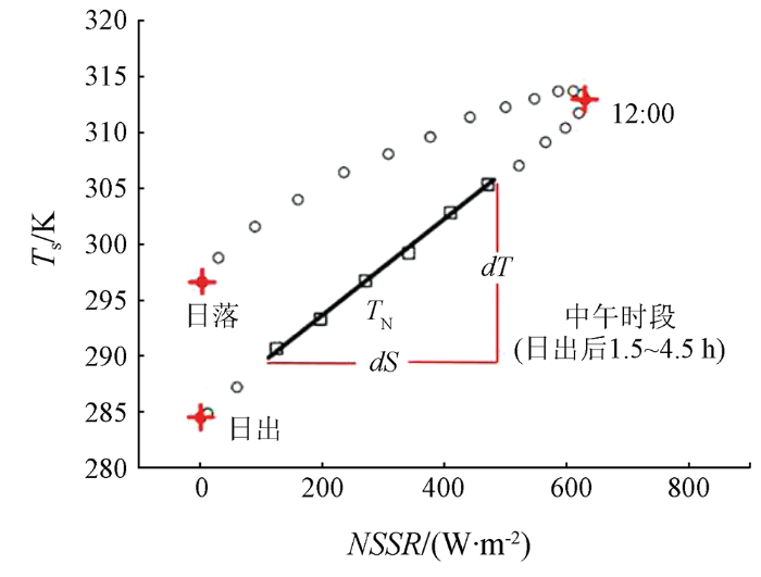
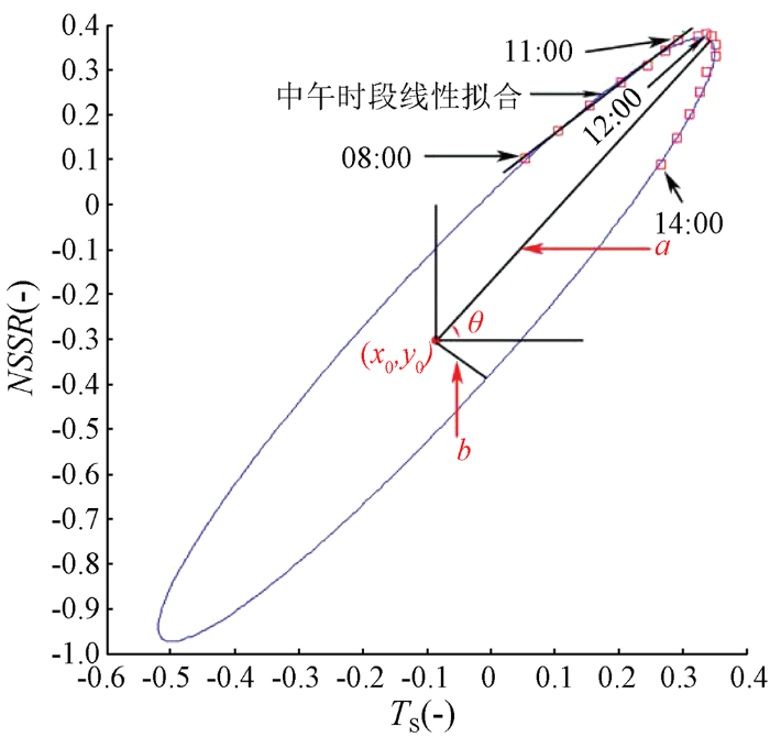
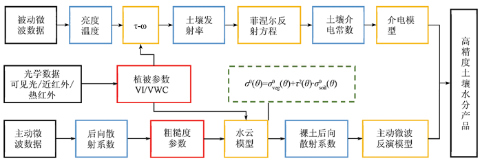

