

0 引言
为保障飞行安全、航班正常以及机场内人员和财产的安全,机场监测需在不停航条件下进行,而传统的监测手段如水准测量和全球导航卫星系统等,难以在不进入跑道的情况下进行长期有效地数据采集,且只能获取离散点位的形变信息。合成孔径雷达干涉测量(interferometric synthetic aperture Radar,InSAR)技术可以实现大范围长时间的监测,具有更高分辨率、重返周期较短,获取地表形变的精度比较高,不需要任何现场安装和供电,可以提供远程测量[5],因此不会对机场的正常运行产生任何影响,是一种更方便、有效的监测手段。
目前,InSAR已广泛用于若干机场的长期沉降监测,Jiang等[6]利用TerraSAR-X数据反演上海浦东国际机场的地表形变序列,并联合地质数据对沉降因素进行定性评价; 麻源源等[7]利用SBAS-InSAR技术提取了昆明长水机场高边坡的形变信息并解算出三维沉降速率图; Dai等[8]利用COSMO-SkyMed数据获得了首都国际机场的形变信息并分析造成沉降的4个驱动因素; 张双成等[9]利用InSAR技术获取安康机场地表形变信息,结合降水和填方数据分析膨胀规律; Shi等[10]基于Sentinel-1数据获取大连金州湾国际机场的形变信息,并根据固结理论对沉降进行预测。但目前对大兴国际机场的研究还停留在传统监测手段,少有基于InSAR的专题沉降研究。
本研究利用39景高分辨率COSMO-SkyMed (CSK)影像和时间序列InSAR技术,对大兴国际机场的地面沉降进行研究,获得大兴机场最新的时空沉降信息,并着重分析跑道等重要位置的形变特征,根据形变特征进一步分析影响沉降的驱动因素,对机场健康、平稳运行提供重要参考。
1 研究区和数据源
北京大兴国际机场位于永定河北岸、北京市大兴区榆垡镇、礼贤镇和河北省廊坊市之间,如图1红色五角星位置所示。北京大兴国际机场定位为大型国际航空枢纽,飞行区等级指标为4F。“五星”方案以航站楼核心区为中心,延伸出5条放射性指廊,再加上楼前区域的服务楼指廊,形成6条指廊的均衡布局,每2条指廊间的夹角为60°[11]。机场运营初期设有4条跑道(图2),呈“三纵一横”布局[12],东跑道(01L/19R)长3 400 m、宽60 m; 西一跑道(17L/35R)、北跑道(11L/29R)长3 800 m、宽60 m; 西二跑道(17R/35L)长3 800 m、宽45 m; 相应设置8条平行滑行道以及联络道系统。
图1
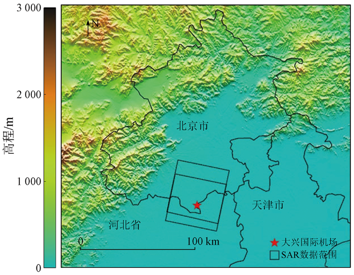
图2

本文获取了2019年9月—2021年12月间的39景高分辨率CSK SAR影像,成像模式为Stripmap 模式,极化方式均为单极化HH,数据空间分辨率为3 m,入射角为17°~22°,波长为3.1 cm。数据覆盖范围如图1中黑色矩形框所示。
2 数据处理
2.1 数据配准
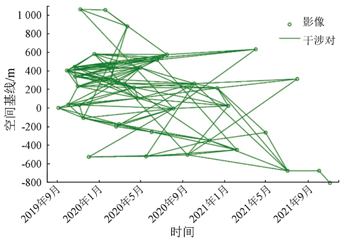
将所有影像统一到相同的空间坐标系下。按时空基线的阈值最优原则选取公共主影像,同时考虑主影像的当日天气情况,本研究选取2019年9月19日的SAR影像作为公共主影像,其他38景影像作为辅影像配准并重采样到主影像上,方位向、距离向配准拟合的标准差均小于0.126。使用30 m分辨率的SRTM数字高程影像进行几何配准和去除大气相位延迟、地平相位等。
对影像数据经过多次实验后选定垂直基线小于300 m且时间基线小于300 d的时空网络进行基线配置,共产生123对干涉对。干涉对连接图如图3所示,图中横轴为SAR影像获取的时间(时间基线长度),纵轴为影像之间的空间基线长度。
图3
2.2 相干目标点选择
选择在时间序列中后向散射特性稳定和高相干性的点作为目标点,以此进行后续的时序分析可以减少长时间序列中存在的失相关现象。本文采取频谱相干系数法和振幅离差阈值法来选择目标点,其中频谱相干系数上下限阈值分别为1和0.33,振幅离差阈值为0.4; 采取联合像素滤波的方法对分布式散射体进行预处理,滤波窗口为21,联合像素大小为3,每个窗口内最小同质点阈值为10。随后计算相位噪声标准差,将阈值设置为0.6 rad对初选的相干目标点进行筛选,最后得到了241 064个相干目标点进行后续的解缠处理。
2.3 相位解缠
此时的干涉相位差值是位于(-π,π]之间的相位主值,它与真实的相位差值之间相差了2kπ,这时它会表现为色带不连续或者蔓延畸形而过长,可以通过路径积分法或者最小二乘法进行相位解缠计算。局部的地表运动和地形误差会引起局部的相位梯度,潮湿的环境和相位梯度会致使相位解缠出现误差[15]。因此,需要仔细选择重采样大小和滤波窗口。较大的重采样大小会以破坏相位一致性为代价来平滑条纹,而较大的滤波窗口可能会丢失干涉图的细节。本次研究估计像元相干性参数窗口大小为7,滤波窗口大小为32。
另外,还需在干涉图中进行解缠误差校正。相位解缠误差是噪声的重要组成部分,这会导致相位历史的估计偏差,并导致反演的残差不为0。通过评定由3个SAR图像形成的3个干涉对之间的相位一致性识别出解缠错误,并纠正相位跳变[16]。干涉图的冗余网络允许通过检查三联干涉相位的一致性来评估观测矢量中的噪声。
3 研究结果
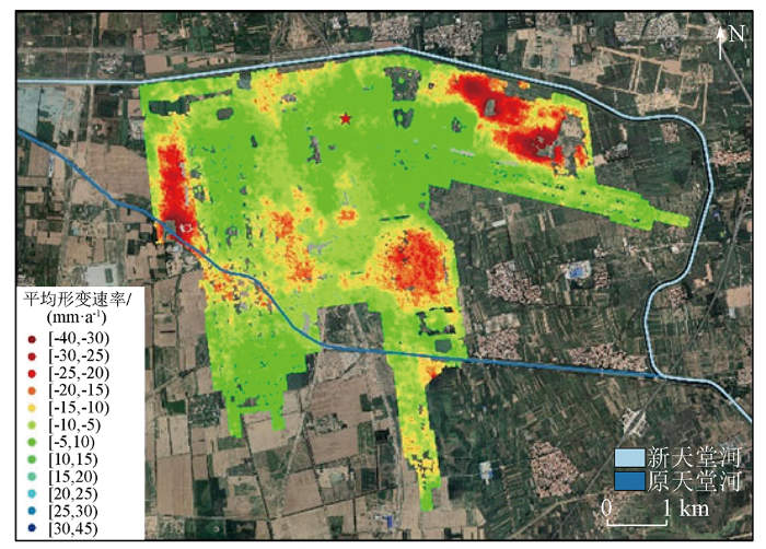
式中: dLOS为视线向位移; du为垂直向位移; θ为视线向与垂直向的夹角。图中红色五角星表示参考点的位置,蓝色的2条线分别代表新、旧天堂河的位置。北京大兴国际机场的沉降在2019—2021年持续发展,最大沉降率为-47.5 mm/a,发生在机场东北部的货运区,形变速率较大的点还存在机务维修区和部分飞行区,本研究对机场关注的区域和形变较大的区域进行深入分析。
图4
3.1 跑道及滑行道监测结果分析
跑道是机场最重要的部分,不均匀的沉降将导致路面凹陷、凸起、开裂或坡度变化,对飞机的平稳起降、乘客的舒适度等都会产生重要影响[17]。本次研究对4条跑道的形变情况进行了进一步分析。
图5
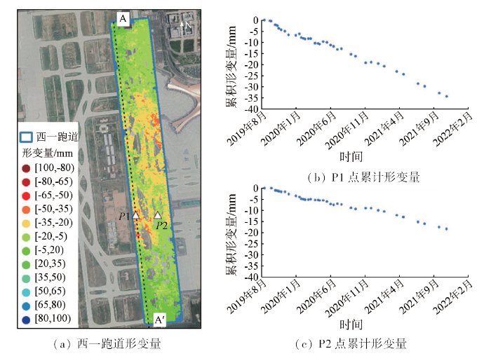
图6
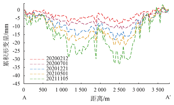
图7
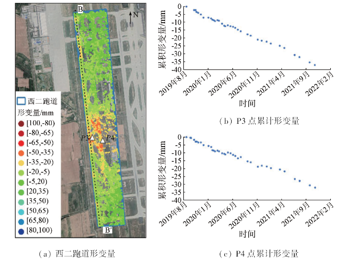
图8
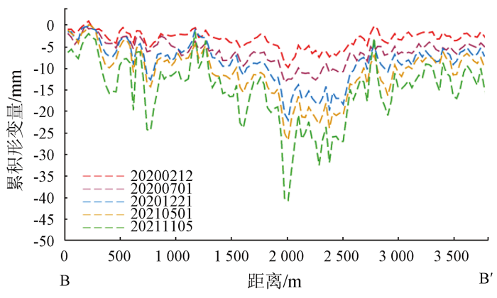
图9
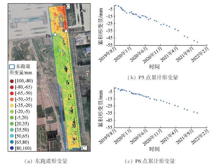
图10
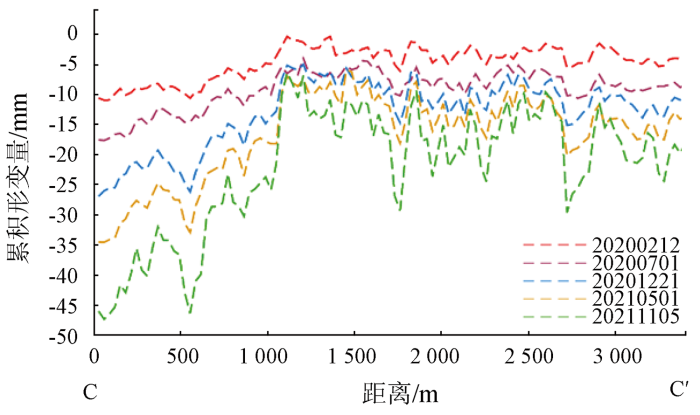
北跑道及其平滑区的卫星影像图和累积形变量如图11所示。东南端的累计沉降较大,约-40 ~-30 mm,最大累计沉降量达-79.96 mm,依次在跑道上和平滑区选取沉降较明显的2个点P7和P8绘制时间序列形变图,发现在2020年7月速度开始增大,建议持续监测。沿跑道绘制剖线DD',绘制剖线的累积位移量如图12所示,从图中可以看出最大沉降量点位于跑道自西向东2 400 m处,跑道自西向东1 800~3 500 m范围都有沉降。按照《民用机场飞行区技术标准》(MH 5001—2013)及其第一修订案,跑道中线上的最高、最低点高差与跑道长度的比值不超过1%,跑道两端各1/4长度内纵坡不超过0.8%,跑道其他部分纵坡不超过1.25%。坡度变化的允许值如表1所示,根据跑道剖线累积位移量,计算坡度变化的最大监测值,结果显示,目前各跑道不均匀沉降还未超过预警值,建议进行长期监测以能及时预警。
图11
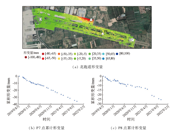
图12
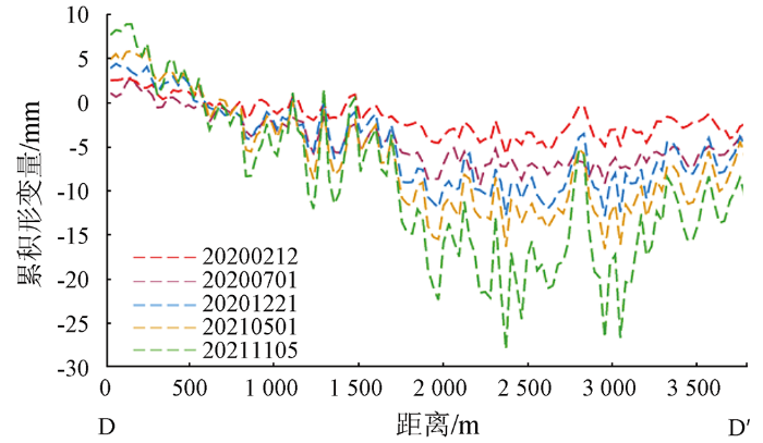
表1 跑道纵坡控制指标
Tab.1
| 跑道 | 位置 | 坡度允 许值 | 坡度变化 允许值 | 坡度变化 监测值 |
|---|---|---|---|---|
| 西一跑道 (北-南) | 北端1/4 | 0.80 | 0.78 | 0.002 07 |
| 中部1/2 | 1.25 | 1.05 | ||
| 南端1/4 | 0.80 | 0.78 | ||
| 西二跑道 (北-南) | 北端1/4 | 0.80 | 0.78 | 0.002 46 |
| 中部1/2 | 1.25 | 1.05 | ||
| 南端1/4 | 0.80 | 0.78 | ||
| 北跑道 (西-东) | 北端1/4 | 0.80 | 0.78 | 0.001 99 |
| 中部1/2 | 1.25 | 1.05 | ||
| 南端1/4 | 0.80 | 0.78 | ||
| 东跑道(北-南) | 北端1/4 | 0.80 | 0.60 | 0.001 21 |
| 中部1/2 | 1.25 | 1.25 | ||
| 南端1/4 | 0.80 | 1.25 |
3.2 其他形变较大区域监测结果
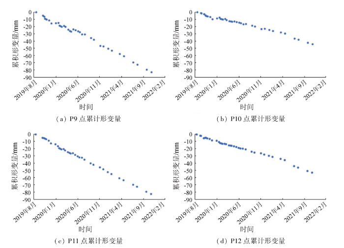
大兴机场在监测时间内存在不均匀的沉降,年平均沉降速率为-47.5 ~ 5.2 mm/a。严重的沉降主要分布在大兴机场的维修机坪、航站楼、油罐区和公务机坪等区域。维修机坪区域最大沉降位置在最南端(P9点),沉降速率为-40.32 mm/a,2019年9月至2021年11月累计沉降最大值为-90.21 mm,此区域形变持续增加。航站楼的最大沉降位置在P10点,沉降速率为-21.36 mm/a。机场东北角处的最大形变位置在油罐区(P11点),沉降速率为-40.45 mm/a,平均沉降量约-40 mm,最大沉降量约-83 mm,沉降速率基本呈线性状态。公务机坪最大沉降位置在K117机位南侧(P12点),沉降速率为-25.38 mm/a,最大沉降量约-78.57 mm。形变较大区域的累积形变量和时间序列形变信息如图13和图14所示。建议对这几处位置持续跟踪监测并加强现场巡逻。
图13
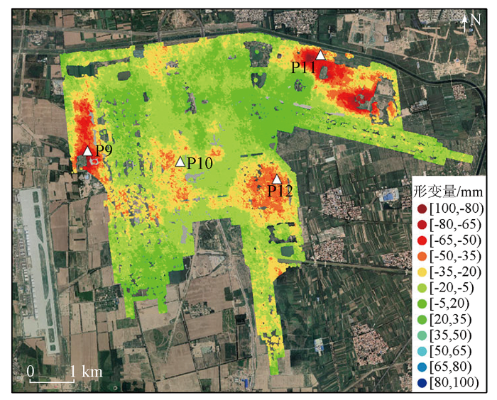
图14
4 讨论
4.1 准确性验证
为了确保InSAR结果的准确性,笔者从监测过程的内符合精度和外部数据验证2个方面进行说明。图15为InSAR所得地表形变速率的标准偏差,标准偏差值越高表示形变速率的不确定度越高,可靠性越低,并且该值通常与快速或不规则地面运动的区域相关。结果表明,整个研究区的标准偏差值较低,范围为0~2,在远离参考点的区域上识别出某几个稍高的标准偏差值。整体数据的内部质量控制达到标准,认为测量结果可靠。除了内符合精度,本研究还取得了E和F这2个点的水准测量结果(图15所示),与InSAR监测对比结果如表2所示。在2020—2021年间,E水准点的高度从24.271 7 m降至24.245 3 m,累积形变量为-19.1 mm,取水准点空间范围内(80 m)的InSAR相干点均值对比,形变值为-19.65 mm,差值为0.55 mm; F水准点的高度从23.2288 m降低至23.2097 m,累积形变量为-26.4 mm,对应InSAR形变值为-25.69 mm,差值为0.71 mm。水准测量值与InSAR观测值并不完全一致,可能由于所选择的InSAR相干目标点与水准点位置并不完全一致,但差值较小,认为观测结果基本可靠。
图15
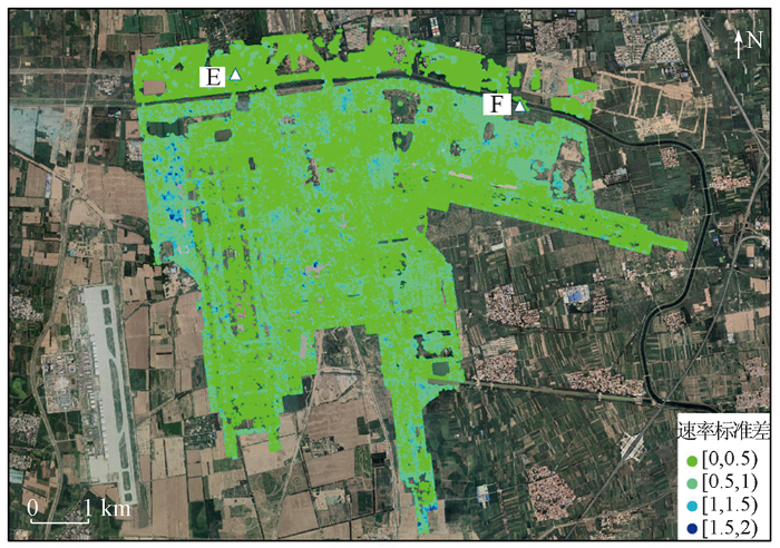
表2 水准测量结果与InSAR观测结果对比
Tab.2
| 点名 | 水准测量结果 | CSK观测结果 | 差值 |
|---|---|---|---|
| E | -19.1 | -19.65 | 0.55 |
| F | -26.4 | -25.69 | 0.71 |
4.2 沉降影响因素分析
图16
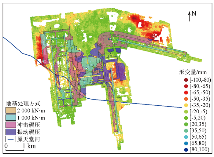
图16
大兴机场地基处理和InSAR监测结果叠加图
Fig.16
Overlay map of ground-based processing and InSAR monitoring results of Daxing Airport
原天堂河区域内的形变普遍大于周边区域。原天堂河依次穿过西二飞行区、西一飞行区和东飞行区,河道与非河道地基处理方式相同: 跑道上均使用1 000 kN·m强夯处理,而天堂河区域需要先进行疏干积水、清除淤泥、挖除河堤等步骤,再进行回填,最后进行强夯处理,在相同的地基处理方式下,回填土与周边地基土易发生差异沉降[21]; 西一飞行区和东飞行区滑行道上天堂河区域和非天堂河区域均使用冲击碾压处理,但在河道区域仍然包括回填部分,使用相同的地基处理方式时,回填部分的地基稳定性可能略小于其他部分。
维修机坪处(图13中P9区域)形变较大,且由北至南形变逐渐增大。从图16中可以看出,维修机坪北部的地基处理方式为1 000 kN·m强夯处理,南部为冲击碾压处理,地基处理的方式差异可能是导致此区域形变较大的原因,冲击碾压是使用冲击碾在牵引车的带动下来冲击地上,从而抵达固结地基土的目的,冲击碾压处理的深度有限,一般的设计都是需求每50 cm分层碾压一次,大兴机场沟塘的处理方式要求压实遍数不小于25遍; 而强夯可以抵达一次性回填一次性处理的效果,根据夯击能的不同,强夯可以处理3~15 m的回填土层,通过强夯冲击可以有效地使这些不均匀沉降较早的体现出来进行填料补充,从而提高路基稳定性,避免工程完工后工后不均匀沉降产生的路面开裂等病害,提高路基整体的密实度和稳定性。
油罐区(图13中P11区域)形变较大,推测原因是地面油罐对地面的堆积荷载所造成,但目前并未掌握油罐区具体的地基处理方式以及储油量的大小,具体的影响方式还需进一步探索。
5 结论
本文以北京大兴国际机场为研究区,选取2019年9月—2021年11月间39景COSMO-SkyMed数据进行时间序列InSAR处理,得到该地区2 a间的累积形变量和形变速率信息,监测结果精度较高,与水准测误差最大值为0.71 mm。结果表明,北京大兴国际机场的沉降在 2019—2021年持续发展,最大沉降速率为-47.5mm/a,4条跑道均存在不均匀沉降,其中,东跑道北部形变尤为明显,形变量达到-53.2 mm。利用高分辨率数据详细分析了跑道在时间、空间上的形变特征,以及其他形变较大区域的形变信息,并据此分析影响沉降的工程方面驱动因素,为确保大兴机场的稳定运营提供重要依据。
在后续的工作中应继续收集时间范围更广泛的SAR数据以及更多的水文地质信息,更加综合全面的分析北京大兴国际机场的沉降原因,为建立风险评估和预测提供重要支撑。
参考文献
The state of land subsidence and prediction approaches due to groundwater withdrawal in China
[J].DOI:10.1007/s11069-007-9168-4 URL [本文引用: 1]
北京大兴规划新城地面沉降研究
[J].
Study on the surface subsidence in Beijing metro planning Daxing
[J].
北京南部地区地面沉降发育特征及成因分析
[J].
Characteristics and causes of land subsidence in the south of Beijing
[J].
Integrated analysis of SAR interferometric and geological data for investigating long-term reclamation settlement of Chek Lap Kok Airport,Hong Kong
[J].DOI:10.1016/j.enggeo.2009.11.005 URL [本文引用: 2]
Measuring precursory movements of the recent Xinmo landslide in Mao County,China with Sentinel-1 and ALOS-2 PALSAR-2 datasets
[J].DOI:10.1007/s10346-017-0914-8 URL [本文引用: 1]
Deformation monitoring and analysis of the geological environment of Pudong international airport with persistent scatterer SAR interferometry
[J].DOI:10.3390/rs8121021 URL [本文引用: 1]
基于SBAS-InSAR技术对昆明机场高边坡沉降监测研究
[J].
Kunming airport high slope settlement monitoring based on SBAS-InSAR
[J].
Diagnosing subsidence geohazard at Beijing capital international airport,from high-resolution SAR interferometry
[J].
DOI:10.3390/su12062269
URL
[本文引用: 1]

Beijing Capital International Airport (BCIA) has suffered from uneven land subsidence since 1935, which affects the smoothness of airport runways and seriously threatens the safety of aircrafts. In this paper, a spaceborne interferometric synthetic aperture radar (InSAR) with high-resolution Cosmo-SkyMed SAR data was utilized at BCIA for the first time to diagnose the subsidence hazard. The results show that subsidence is progressing at BCIA at a maximum rate of 50 mm/year, which is mainly distributed in the northwest side of the airport. It was found that the Shunyi-Liangxiang fault directly traverses Runway2 and Runway3 and causes uneven subsidence, controlling the spatial subsidence pattern to some degree. Four driving factors of subsidence were investigated, namely: the over-exploitation of groundwater, active faults, compressible soil thickness, and aquifer types. For the future sustainable development of BCIA, the influence of Beijing new airport and Beijing Daxing International Airport (BDIA), was analyzed and predicted. It is necessary to take relevant measures to control the uneven subsidence during the initial operation of BDIA and conduct long-term monitoring to ensure the regular safe operation of BCIA. This case demonstrates a remote sensing method of diagnosing the subsidence hazard with high accuracy and non-contact, providing a reliable alternative for the geohazard diagnosis of key infrastructures in the future.
时序InSAR用于安康膨胀土机场稳定性监测
[J].
Time-series InSAR for stability monitoring of Ankang Airport with expansive soil
[J].
Monitoring and predicting the subsidence of Dalian Jinzhou Bay International Airport,China by integrating InSAR observation and Terzaghi consolidation theory
[J].
DOI:10.3390/rs14102332
URL
[本文引用: 1]
Dalian Jinzhou Bay International Airport (DJBIA) is an offshore artificial island airport, where the reclaimed land is prone to uneven land subsidence due to filling consolidation and construction. Monitoring and predicting the subsidence are essential to assist the subsequent subsidence control and ensure the operational safety of DJBIA. However, the accurate monitoring and prediction of reclaimed subsidence for such a wide area under construction are hard and challenging. This paper utilized the Small Baseline Subset Synthetic Aperture Radar (SBAS-InSAR) technology based on Sentinel-1 images from 2017 to 2021 to obtain the subsidence over the land reclamation area of the DJBIA, in which the results from ascending and descending orbit data were compared to verify the reliability of the results. The SBAS-InSAR results reveal that uneven subsidence is continuously occurring, especially on the runway, terminal, and building area of the airport, with the maximum subsidence rate exceeding 100 mm/year. It was found that there is a strong correlation between the subsidence rate and backfilling time. This study provides important information on the reclaimed subsidence for DJBIA and demonstrates a novel method for reclaimed subsidence monitoring and prediction by integrating the advanced InSAR technology and Terzaghi Consolidation Theory modeling. Moreover, based on the Terzaghi consolidation theory and the corresponding geological parameters of the airport, predicted subsidence curves in this area are derived. The comparison between predicted curves and the actual subsidence revealed by InSAR in 2017–2021 is highly consistent, with a similar trend and falling in a range of ±25 mm/year, which verifies that the subsidence in this area conforms to Terzaghi Consolidation Theory. Therefore, it can be predicted that in the future, the subsidence rate of the new reclamation area in this region will reach about 80 mm/year ± 25 mm/year, and the subsidence rate will gradually slow down with the accumulation of reclamation time. The subsidence rate will slow down to about 30 mm/year ± 25 mm/year after 10 years.
北京大兴国际机场绿色运营实践与展望
[J].
Practice and prospect of green operation of Beijing Daxing International Airport
[J].
COSMO-SkyMed an existing opportunity for observing the Earth
[J].DOI:10.1016/j.jog.2010.01.001 URL [本文引用: 1]
Land subsidence in Beijing and its relationship with geological faults revealed by Sentinel-1 InSAR observations
[J].DOI:10.1016/j.jag.2019.05.019 URL [本文引用: 2]
Testing sentinel-1 SAR interferometry data for airport runway monitoring:A geostatistical analysis
[J].
DOI:10.3390/s21175769
URL
[本文引用: 1]
Multi-Temporal Interferometric Synthetic Aperture Radar (MT-InSAR) techniques are gaining momentum in the assessment and health monitoring of infrastructure assets. Amongst others, the Persistent Scatterers Interferometry (PSI) technique has proven to be viable for the long-term evaluation of ground scatterers. However, its effectiveness as a routine tool for certain critical application areas, such as the assessment of millimetre-scale differential displacements in airport runways, is still debated. This research aims to demonstrate the viability of using medium-resolution Copernicus ESA Sentinel-1A (C-Band) SAR products and their contribution to improve current maintenance strategies in case of localised foundation settlements in airport runways. To this purpose, “Runway n.3” of the “Leonardo Da Vinci International Airport” in Fiumicino, Rome, Italy was investigated as an explanatory case study, in view of historical geotechnical settlements affecting the runway area. In this context, a geostatistical study is developed for the exploratory spatial data analysis and the interpolation of the Sentinel-1A SAR data. The geostatistical analysis provided ample information on the spatial continuity of the Sentinel 1 data in comparison with the high-resolution COSMO-SkyMed data and the ground-based topographic levelling data. Furthermore, a comparison between the PSI outcomes from the Sentinel-1A SAR data—interpolated through Ordinary Kriging—and the ground-truth topographic levelling data demonstrated the high accuracy of the Sentinel 1 data. This is proven by the high values of the correlation coefficient (r = 0.94), the multiple R-squared coefficient (R2 = 0.88) and the Slope value (0.96). The results of this study clearly support the effectiveness of using Sentinel-1A SAR data as a continuous and long-term routine monitoring tool for millimetre-scale displacements in airport runways, paving the way for the development of more efficient and sustainable maintenance strategies for inclusion in next generation Airport Pavement Management Systems (APMSs).
Ground settlement of Chek Lap Kok Airport,Hong Kong,detected by satellite synthetic aperture Radar interferometry
[J].DOI:10.1007/BF02900548 URL [本文引用: 1]
Unexpected excessive settlements:Kansai international airport,Japan
[M]//Geomechanics of Failures.
State of the art:Asphalt for airport pavement surfacing
[J].DOI:10.1016/j.ijprt.2017.07.008 URL [本文引用: 1]
