Application of high-resolution InSAR technique in monitoring deformations in the Beijing Daxing International Airport
ZHAO Xia1,2(), MA Xinyan1,2(), YU Qian1,2, WANG Zhaobing1,2
1. China Airport Planning & Design Institute Co., Ltd., Beijing 100029, China 2. Observation and Research Base of Transport Industray of Airport Engineering Safety and Long-term Performance, Beijing 100029, China
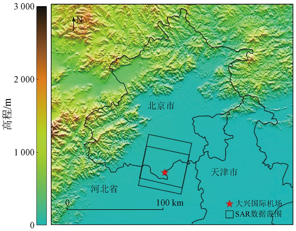
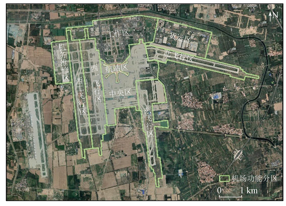
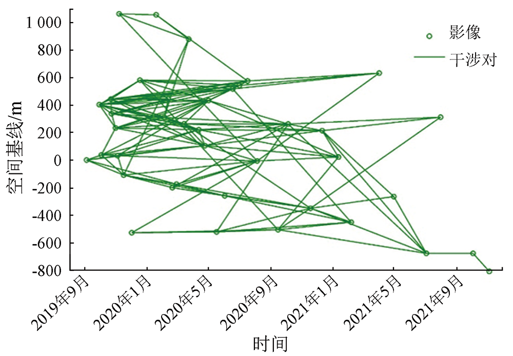
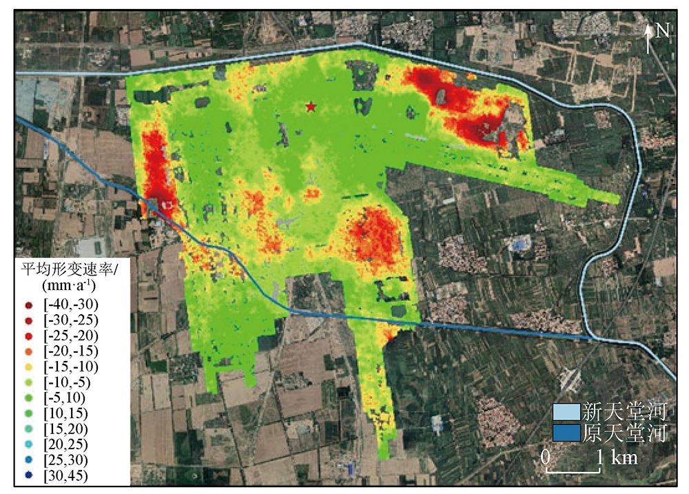
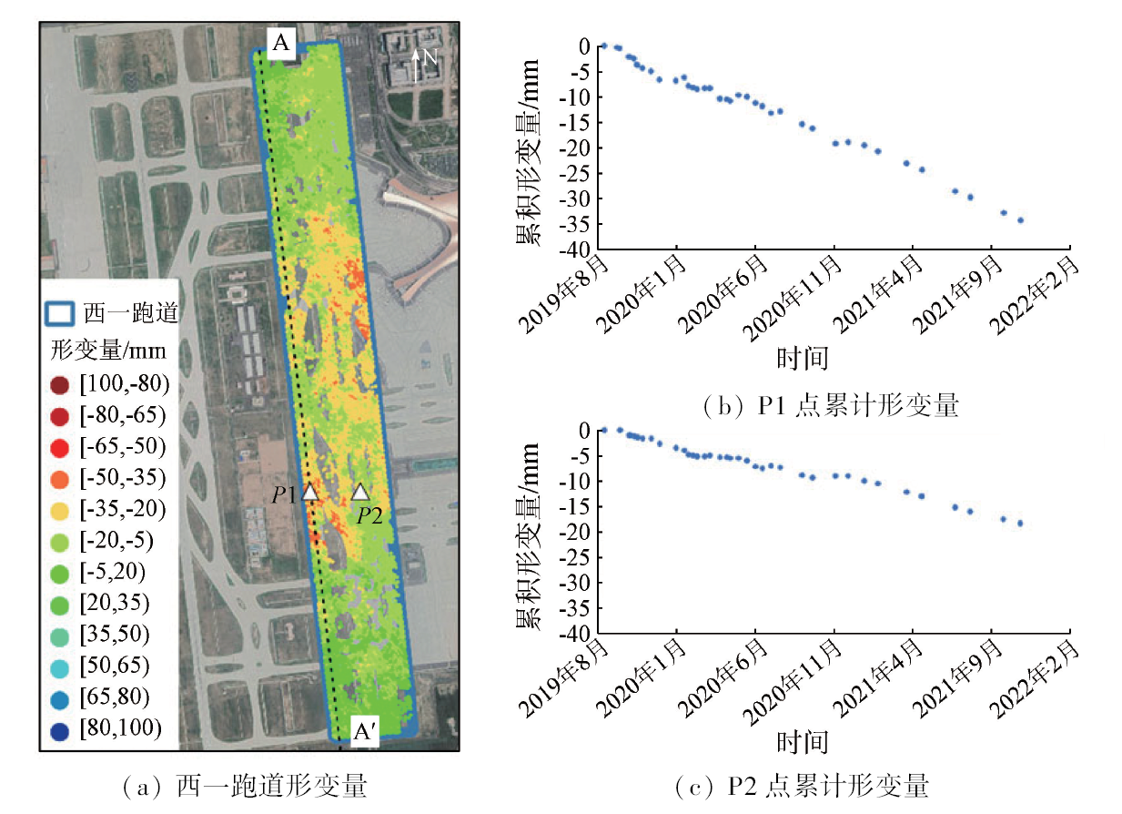
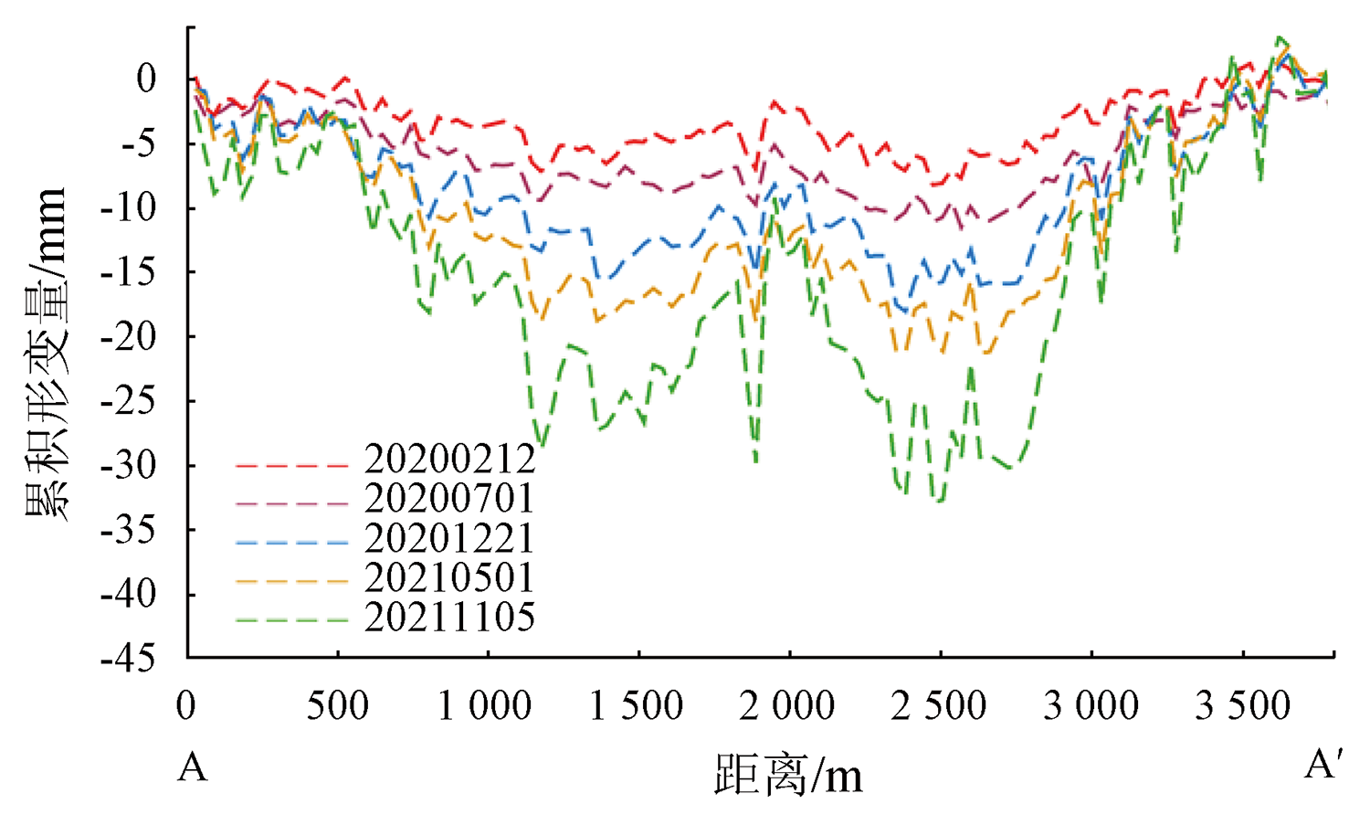
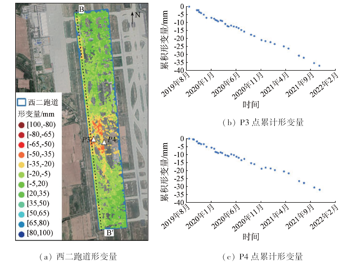
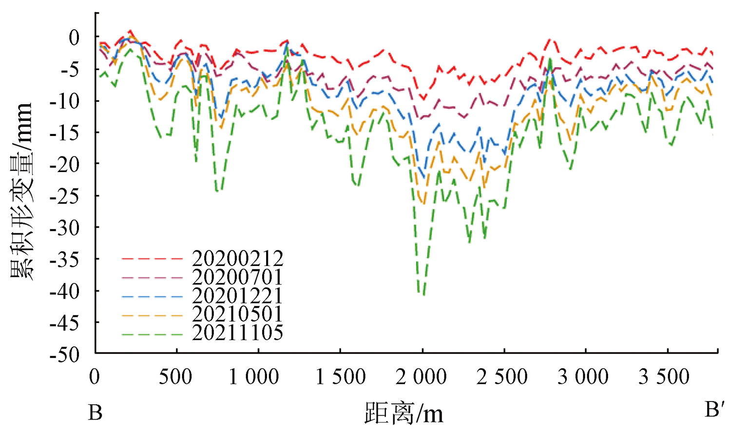
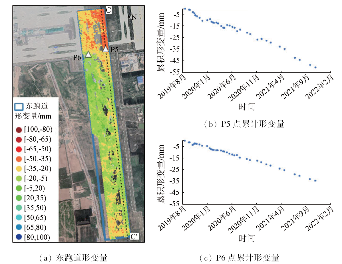
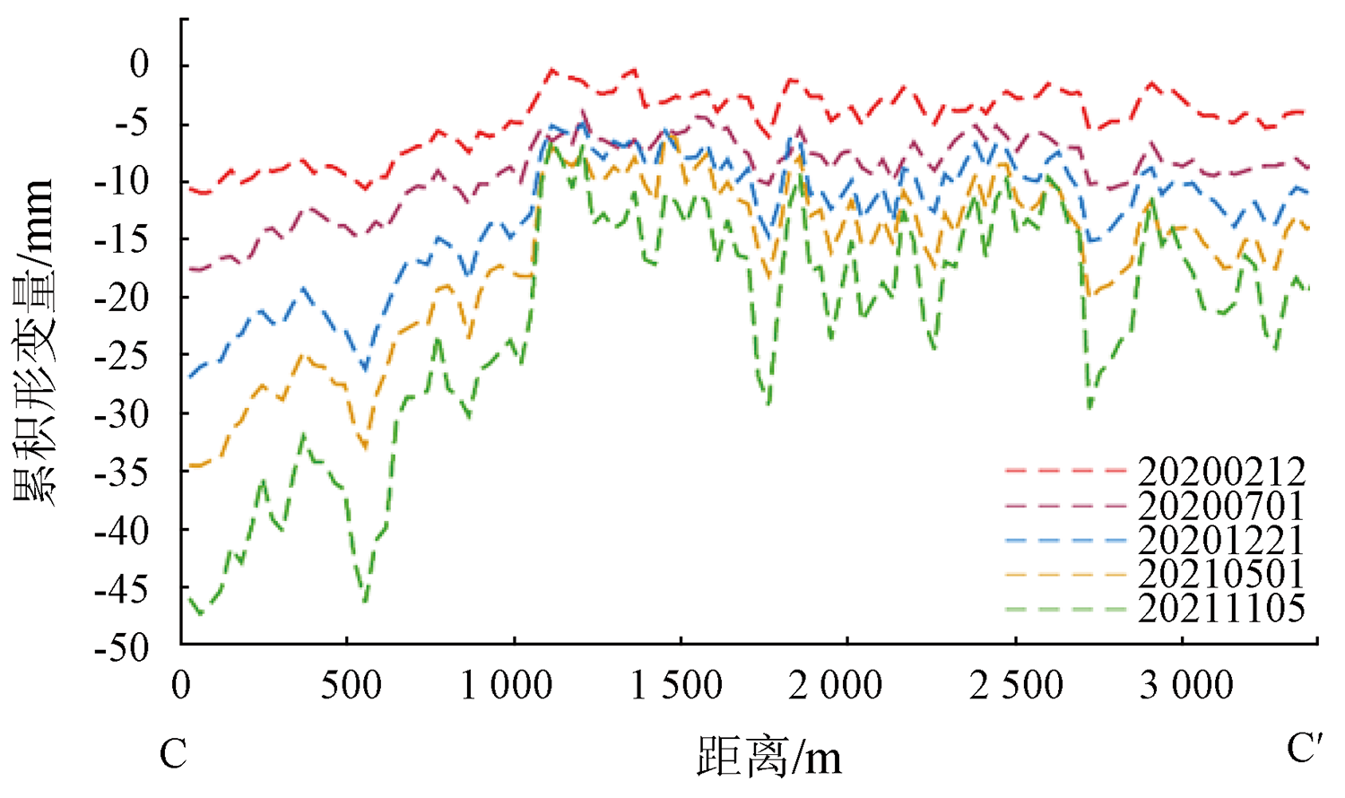
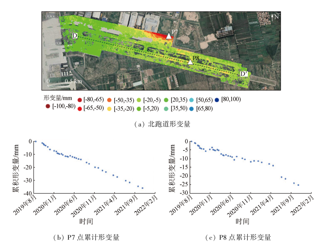
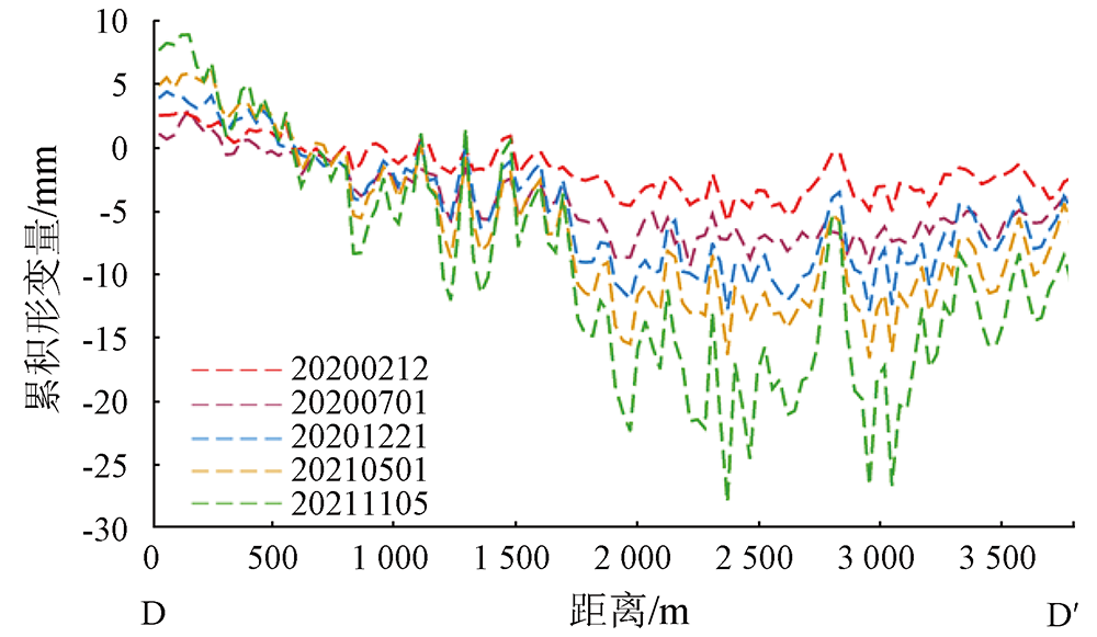
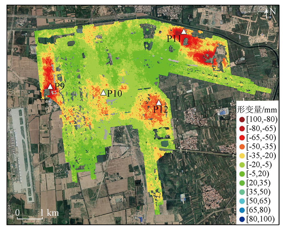
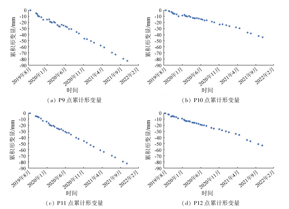
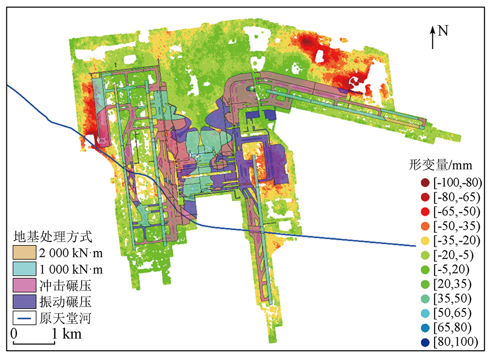
The Beijing Daxing International Airport, located in the Yufa—Lixian area of Daxing District, is one of Beijing’s five major land subsidence areas. Differential deformations pose risks to the airport’s safe and stable operation. By applying the time-series interferometric synthetic aperture Radar (InSAR) technique, this study obtained the spatio-temporal characteristics of the airport’s deformations from 39 scenes of high-resolution COSMO-SkyMed (CSK) SAR images taken from September 2019 to November 2021. The monitoring results, with high accuracy, are roughly consistent with level monitoring results. Findings indicate that the airport’s subsidence lasted from 2019 to 2021, with the highest subsidence rate measured at -47.5 mm/a and a maximum cumulative subsidence amount of -103.84 mm. Notably, all four runways exhibited varying degrees of differential subsidence. Furthermore, this study delved into the spatio-temporal characteristics of deformations in the runways, as well as deformations in other high-deformation zones such as terminal buildings, maintenance aprons, oil tank areas, and the business jet apron. By combining the foundation treatment, this study analyzed the factors influencing the airport’s subsidence, providing a reference for the airport’s safe and stable operation.
赵霞, 马新岩, 余虔, 王招冰. 高分辨率InSAR技术在北京大兴国际机场形变监测中的应用[J]. 自然资源遥感, 2024, 36(1): 49-57.
ZHAO Xia, MA Xinyan, YU Qian, WANG Zhaobing. Application of high-resolution InSAR technique in monitoring deformations in the Beijing Daxing International Airport. Remote Sensing for Natural Resources, 2024, 36(1): 49-57.
Xu Y S, Shen S L, Cai Z Y, et al. The state of land subsidence and prediction approaches due to groundwater withdrawal in China[J]. Natural Hazards, 2008, 45(1):123-135.
doi: 10.1007/s11069-007-9168-4
Luo Y, Jia S M, Zhao B, et al. Characteristics and causes of land subsidence in the south of Beijing[J]. Urban Geology, 2011, 6(3):1-5,21.
[4]
Jiang L, Lin H. Integrated analysis of SAR interferometric and geological data for investigating long-term reclamation settlement of Chek Lap Kok Airport,Hong Kong[J]. Engineering Geology, 2010, 110(3/4):77-92.
doi: 10.1016/j.enggeo.2009.11.005
[5]
Dong J, Zhang L, Li M, et al. Measuring precursory movements of the recent Xinmo landslide in Mao County,China with Sentinel-1 and ALOS-2 PALSAR-2 datasets[J]. Landslides, 2018, 15(1):135-144.
doi: 10.1007/s10346-017-0914-8
[6]
Jiang Y, Liao M, Wang H, et al. Deformation monitoring and analysis of the geological environment of Pudong international airport with persistent scatterer SAR interferometry[J]. Remote Sensing, 2016, 8(12):1021.
doi: 10.3390/rs8121021
Ma Y Y, Zuo X Q, Ma W F, et al. Kunming airport high slope settlement monitoring based on SBAS-InSAR[J]. Geotechnical Investigation & Surveying, 2018, 46(7):22-27,39.
[8]
Dai K, Shi X, Gou J, et al. Diagnosing subsidence geohazard at Beijing capital international airport,from high-resolution SAR interferometry[J]. Sustainability, 2020, 12(6):2269.
doi: 10.3390/su12062269
Zhang S C, Si J Z, Xu Y F, et al. Time-series InSAR for stability monitoring of Ankang Airport with expansive soil[J]. Geomatics and Information Science of Wuhan University, 2021, 46(10):1519-1528.
[10]
Shi X, Chen C, Dai K, et al. Monitoring and predicting the subsidence of Dalian Jinzhou Bay International Airport,China by integrating InSAR observation and Terzaghi consolidation theory[J]. Remote Sensing, 2022, 14(10):2332.
doi: 10.3390/rs14102332
[11]
丛易敏行. 机场场道变形监测及预警研究[D]. 北京: 北京航空航天大学, 2020.
Cong Y M X. Research on monitoring and prediction of deformation on airport runway[D]. Beijing: Beihang University, 2020.
Zhao J H, Zhang X F, Wang L B, et al. Practice and prospect of green operation of Beijing Daxing International Airport[J]. Environmental Protection, 2021, 49(11):18-21.
[13]
Caltagirone F, Angino G, Coletta A, et al. COSMO-SkyMed program:Status and perspectives[M].Pisa,Italy: 2003:24-26.
[14]
Battazza F, Coletta A, Lopinto E, et al. COSMO-SkyMed an existing opportunity for observing the Earth[J]. Journal of Geodynamics, 2010, 49(3/4):171-180.
doi: 10.1016/j.jog.2010.01.001
[15]
Hu L, Dai K, Xing C, et al. Land subsidence in Beijing and its relationship with geological faults revealed by Sentinel-1 InSAR observations[J]. International Journal of Applied Earth Observation and Geoinformation, 2019, 82:101886.
doi: 10.1016/j.jag.2019.05.019
[16]
Fattahi H. Geodetic imaging of tectonic deformation with InSAR[D]. Miami: University of Miami, 2015.
[17]
Gagliardi V, Bianchini Ciampoli L, Trevisani S, et al. Testing sentinel-1 SAR interferometry data for airport runway monitoring:A geostatistical analysis[J]. Sensors, 2021, 21(17):5769.
doi: 10.3390/s21175769
[18]
Liu G, Ding X, Chen Y, et al. Ground settlement of Chek Lap Kok Airport,Hong Kong,detected by satellite synthetic aperture Radar interferometry[J]. Chinese Science Bulletin, 2001, 46(21):1778-1782.
doi: 10.1007/BF02900548
[19]
Puzrin A M, Alonso E E, Pinyol N M. Unexpected excessive settlements:Kansai international airport,Japan[M]//Geomechanics of Failures. Dordrecht:Springer, 2010:23-43.
[20]
White G. State of the art:Asphalt for airport pavement surfacing[J]. International Journal of Pavement Research and Technology, 2018, 11(1):77-98.
doi: 10.1016/j.ijprt.2017.07.008
Liang Y H, Wang W D, Feng S J, et al. Field study on treatment of collapsible silt for high-fill airport project[J]. Chinese Journal of Geotechnical Engineering, 2022, 44(6):1027-1035.
 2024, Vol. 36
  ), 马新岩1,2(