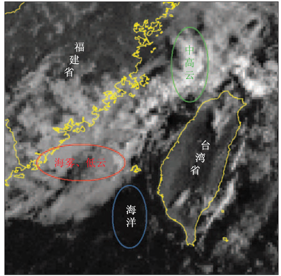
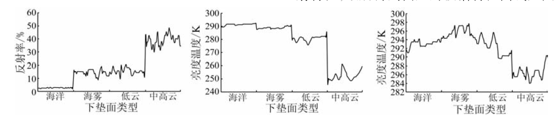
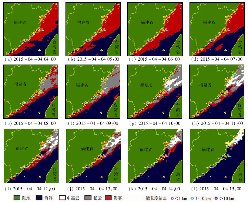
In this paper, the authors analyzed the variation law of visible light, thermal infrared band and mid-infrared band of FY geostationary satellite for sea fog, clouds and sea surface (clear sky) in Taiwan Strait, which was based on a lot of experimental analyses by using different phases of satellite data, combined with the visibility data of automatic meteorological stations. On such a basis, reflectivity threshold was used to separate sea fog and cloud from sea surface, and brightness temperature threshold was used to separate sea fog and low cloud from middle and high cloud. In addition, night sea fog was automatically identified by the normalized difference index of mid-infrared and thermal infrared band. Finally, the automatic monitoring software system of Taiwan Strait sea fog was established, and surface observation data were used to examine the precision of remote sensing monitoring. The research results show that FY geostationary satellite could make up for the deficiency of Polar Orbit Satellite in time resolution, and it has a good performance on the dynamic monitoring service of Taiwan Strait. A comparison shows that the remote sensing monitoring results of sea fog are in accordance with observation results, and the monitoring accuracy is more than 70% in daytime. Night time accuracy is lower than that of the day time, and there exists limitation in the separation of sea fog and low cloud.
张春桂, 林炳青. 基于FY-2E卫星数据的福建沿海海雾遥感监测[J]. 国土资源遥感, 2018, 30(1): 7-7.
Chungui ZHANG, Bingqing LIN. Application of FY-2E data to remote sensing monitoring of sea fog in Fujian coastal region. Remote Sensing for Land & Resources, 2018, 30(1): 7-7.
Zheng X J.On satellite imagery features of sea fogs over the Yellow Sea[J].Meteorological Monthly,1988,14(6):7-9.
[2]
Ellrod G P.Advances in the detection and analysis of fog at night using GOES multispectral infrared imagery[J].Weather and Forecasting,1995,10(3):606-619.
[3]
Ahn M H,Sohn E H,Hwang B J.A new algorithm for sea fog/stratus detection using GMS-5 IR data[J].Advances in Atmospheric Sciences,2003,20(6):899-913.
Bao X W,Wang X,Sun L T,et al.The weatherproof detection system of sea fog by remote sensing and its applications[J].High Technology Letters,2005,15(1):101-106.
Zhang J W,Zhang S P,Wu X J,et al.The research on Yellow Sea sea fog based on MODIS data:Sea fog properties retrieval and spatial-temporal distribution[J].Periodical of Ocean University of China,2009,39(S1):311-318.
Ma H Y,Fan C,Zhao X D.An algorithm for separating cloud-fog from surface features based on mixed pixels[J].Remote Sensing for Land and Resources,2010,22(1):55-59.doi:10.6046/gtzyyg/2010.01.09.
Zhang W K,Ma H Y,Zou Z R,et al.Automatic detection of night time radiation fog based on SBDART radiative transfer model and the analysis of time series[J].Remote Sensing for Land and Resources,2014,26(2):80-86.doi:10.6046/gtzyyg/2014.02.14.
Wu X J,Li S M,Liao M,et al.Analyses of seasonal feature of sea fog over the Yellow Sea and Bohai Sea based on the recent 20 years of satellite remote sensing data[J].Acta Oceanologica Sinica,2015,37(1):63-72.
He Y,Zhang X W,Du H L,et al.Monitoring sea fog of Zhejiang from geostationary meteorological satellite data[J].Remote Sensing Technology and Application,2015,30(3):599-606.
[10]
Bendix J,Thies B,Cermak J,et al.Ground fog detection from space based on MODIS daytime data-a feasibility study[J].Weather and Forecasting,2005,20(6):989-1005.
 2018, Vol. 30
  ), 林炳青