Research on remote sensing monitoring of zirconium-titanium sand mine exploitation and strategies of ecological restoration on the eastern beach of Hainan Island
Yuling ZHAO1, Jinzhong YANG1, Yaqiu YIN1, Hang ZHAO2, Jinbao HE2, Han ZHANG2
1. China Aero Geophysical Survey and Remote Sensing Center for Natural Resources, Beijing 100083, China 2. School of Earth Sciences and Resources, China University of Geosciences (Beijing), Beijing 100083, China
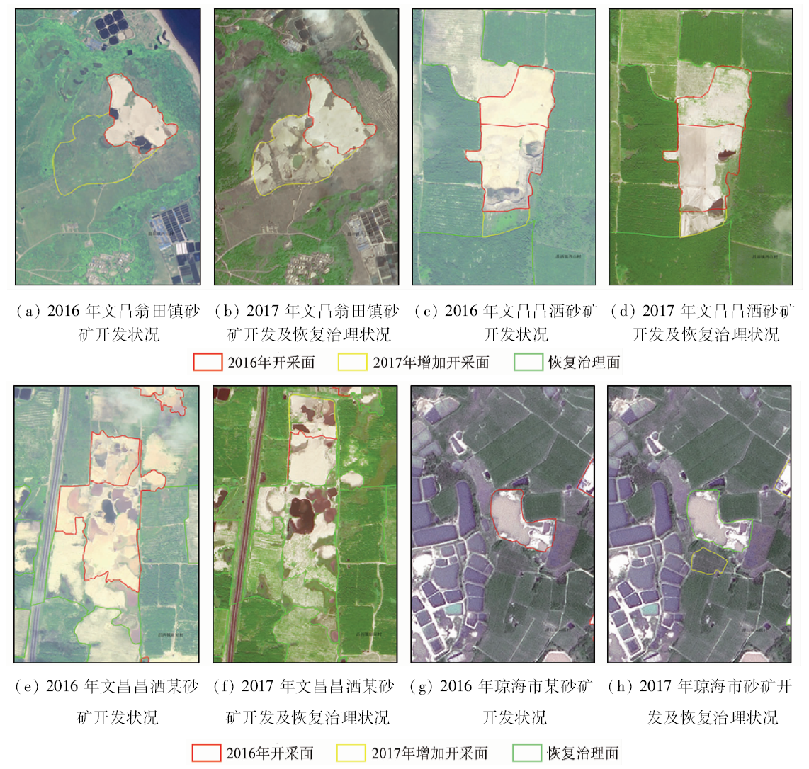
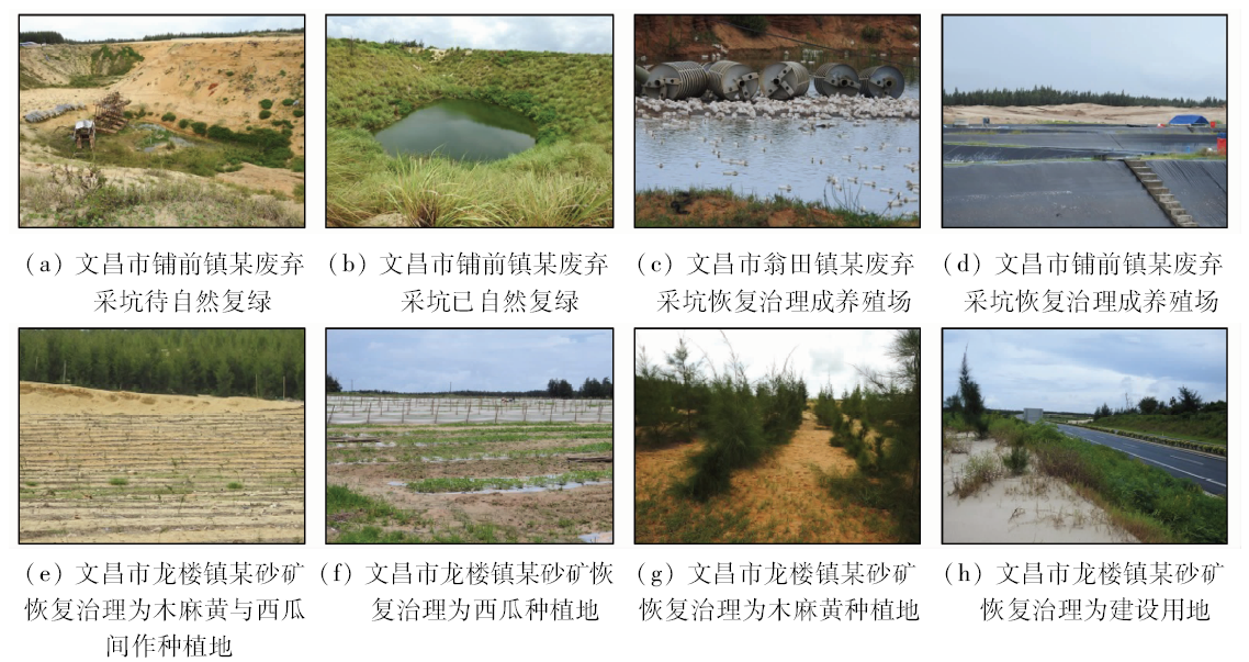
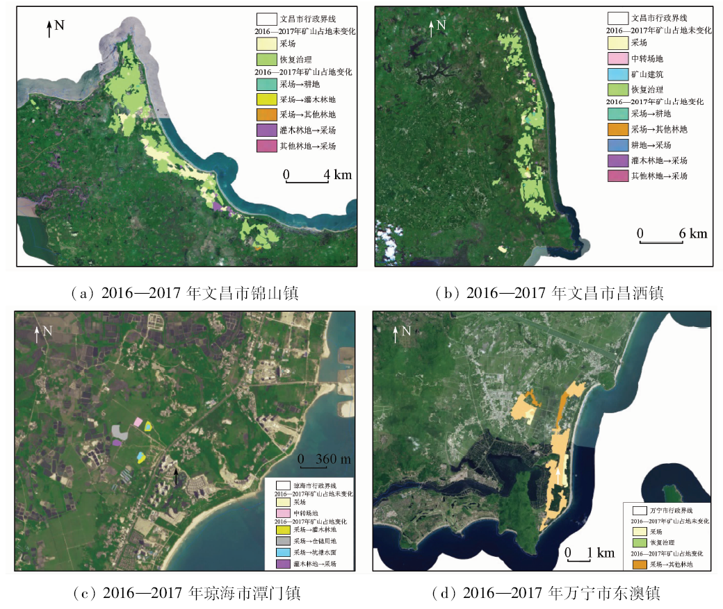
With the popularity of the idea that clear waters and green mountains are as valuable as mountains of gold and silver, rehabilitation of mine environment has become an important part of national ecological civilization. The eastern coast of Hainan Island is one of the most potential areas for uhligite exploitation. However, long-term mining activities have destructed the original ecological environment of that area, leading to the fact that the local ecological environment has become poorer and needs to be rebuilt urgently. By using high resolution remote sensing data, exploitation and recovery conditions of beach placers from 2016 to 2017 in the eastern coast of Hainan island were monitored. The results indicate that, from 2016 to 2017, damaged areas of zirconium-titanium sand mine grew by 40.65 hm 2 and the number of exploitation surfaces increased by 15. The exploitation presents a tendency that the scale was reduced and distributed. Besides, during 2016 to 2017, recovery areas of mine ecological environment grew to some extent and the mine environment conditions showed a tendency of improvement. Through annual comparison and analysis, the authors proposed treatment advice for mining wasteland of zirconium-titanium sand mine as follows: Casuarina equisetifolia could be used as the main species, combined with vatican hainanensis, acacia confuse, and slash pine as accessory species, to restore the forest ecosystem of the mining area; in addition, watermelons, sweet potatoes, peanuts and some other crops could be also applied to conducting restoration experiments in some representative regions; furthermore, damaged mining areas may also be rebuilt into seawater farms.
赵玉灵, 杨金中, 殷亚秋, 赵航, 何金宝, 张汉. 海南岛东部滨海锆钛砂矿开发状况遥感监测与生态恢复治理对策研究[J]. 国土资源遥感, 2019, 31(4): 143-150.
Yuling ZHAO, Jinzhong YANG, Yaqiu YIN, Hang ZHAO, Jinbao HE, Han ZHANG. Research on remote sensing monitoring of zirconium-titanium sand mine exploitation and strategies of ecological restoration on the eastern beach of Hainan Island. Remote Sensing for Land & Resources, 2019, 31(4): 143-150.
He Z X . The exploitation situation and development strategies of Zr-Ti resource in Hainan Province[J].China Nonferrous Metals Techno-Economic Research,1992(2):35-37.
Lin M K, Lin C S, Pan Y J , et al. The brief analysis on mineral character and minerogenetic condition of offshore Zr-Ti placer in eastern Hainan Province[J].West-China Exploration Engineering,2016(11):141-143.
Han X H, Wang X M, Chen W , et al. The distributing characteristics of the marginal marine placer deposit resources in the eastern Hainan Island[J]. China Mining Magazine, 2017,26(s1):246-250.
Zhang Z Z . The application of high-resolution satellite IKONOS images in monitoring of Hainan zirconium titanium sand mine[J].Technology Wind,2013(18):122-123.
Chen Z, Yang H N, Yan W , et al. Distributions and divisions of mineral resources in the sea areas of China:Placer deposit and ferromanganese nodule/crust[J]. Marine Geology and Quaternary Geology, 2006,26(5):101-108.
Guo Y B . Study on the countermeasures of environmental recovery and treatment of typical mines in Yunnan Province based on remote sensing technology[J].Science Mosaic,2017(9):169-173.
Yao B Q, Liu Q . Progress in research of the construction of coastal windbreak forest with mixed species along the southeastern coast in China[J].Protection Forest Science and Technology,2010(3):58-61.
Wang S A, Xue Y, Fu X G , et al. Afforestation technology at the abandoned Titanium mine land with Casuarina equisetifolia[J]. Tropical Forestry, 2008,36(3):27-28.
[10]
彭少麟 . 恢复生态学与植被重建[J]. 生态科学, 1996,15(2):26-31.
Peng S L . Restoration ecology and vegetation reconstruction[J]. Ecologic Science, 1996,15(2):26-31.
[11]
彭少麟 . 恢复生态学与退化生态系统的恢复[J].中国科学院院刊,2000(3):188-192.
Peng S L . Restoration ecology and degradated ecosystems rehabilitation[J].Bulletin of Chinese Academy of Sciences,2000(3):188-192.
[12]
杨彩霞 . 露天矿山生态环境恢复治理若干方法探讨[J].石化技术,2017(5):59.
Yang C X . Discussion on ecological environment recovery and management of open-pit mine[J].Petrochemical Industry Technology,2017(5):59.
Lan M J, Wu W S, Pan H , et al. Effects of different plastic film mulching on soil temperature and sweet potato production[J]. Jiang-su Agricultural Sciences, 2015,43(1):104-105.
Yang W B, Fu D Q, Liu L Y , et al. Research status and prospects of peanut in Hainan Province[J]. Chinese Journal of Tropical Agriculture, 2013,33(5):73-75.
Zhang C Y, Yu G X, Wu G Y .Research on the effects of plastic film mulching cultivation of sweet potatoes[J].Modern Agricultural Science and Technology, 2011( 16): 47, 50.
[21]
曲仲湘 . 海南岛青梅林的发现[J]. 林业科学, 1956,( 3):279-281.
Qu Z X . The discovery of Vatica mangachapoi forest in Hainan Island[J]. Scientia Silvae Sinicae, 1956,( 3):279-281.
Liang S Q, Lin Y, Yang X B , et al. The Vatica hainanensis forest located in Liji,Wanning,Hainan Province[J]. Natural Sciences Journal of Hainan University, 1993,11(4):1-9.
Liang S Q, Lin Y, Yang X B , et al. The Vatica hainanensis forest located in Liji,Wanning,Hainan Province (continued)[J]. Natural Sciences Journal of Hainan University, 1994,12(1):14-19.
Liang S Q, Lin Y, Yang X B , et al. The Vatica hainanensis forest located in Liji,Wanning,Hainan Province(the end)[J]. Natural Sciences Journal of Hainan University, 1994,12(2):129-135.
 2019, Vol. 31