Application of mine remote sensing monitoring to analysis of mine goaf stability
Xianhua YANG1,2, Jie HUANG1,2, Li TIAN1, Bei PENG1, Lixiao XIAO1, Xinlong SONG1
1. Sichuan Institute of Geological Survey, Chengdu 610081, China 2. Evaluation and Utilization of Strategic Rare Metals and Rare Earth Resource Key Laboratory of Sichuan Province, Chengdu 610081, China
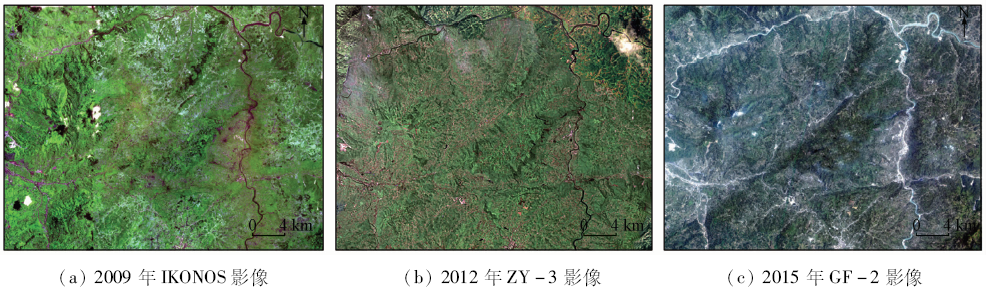
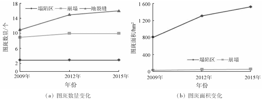
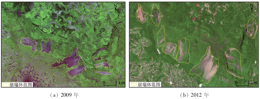
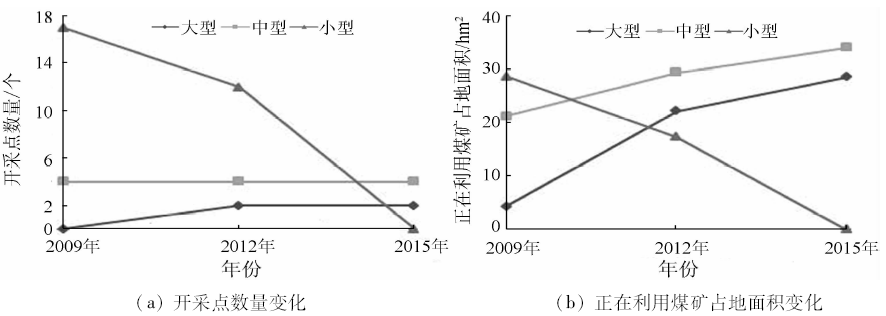
Focused on deformation trends of mine goaf areas, the remote sensing monitoring techniques were employed to interpret and compare the multi-temporal satellite images. According to images acquired in 2009, 2012 and 2015 respectively, land cover change information including mine goaf areas, mine digging points and other land use types in the Junlian coal mining area of Sichuan Province were acquired. By analyzing the correlation between the mining exploitation environment changes and mine goaf area change trends, the authors pointed out that the status alteration of coal mining can directly affect the mine goaf change trend. On the basis of the remote sensing monitoring results, stability analysis of mine goaf areas was conducted, the continuous and newly increased deformation information was calculated, and the categorized prediction maps of mine goaf deformation trends were presented, which can assist further specified measures for mining environment protection.
Huang J, Shao H Y, Yang X H , et al. Methods and Practice on Remote Sensing Monitoring of Mine Development in Sichuan Province[M]. Beijing: Surveying and Mapping Press, 2013: 31-36.
Zha D P, Shen Z, Liu Z G , et al. Changes of ecological environment in the Dexing copper mine based on TM images[J]. Remote Sensing for Land and Resources, 2015,27(4):109-114.doi: 10.6046/gtzyyg.2015.04.17.
Chai H B, Song B, Liu R B , et al. Research status of foundation bearing capacity in coal mining subsidence area[J]. Journal of Henan Polytechnic University(Natural Science), 2014,33(2):173-176.
Zhang D Q, Zhang J D, Bai G Y , et al. A study of the stability analysis of ground collapse in goaf of coal mine[J]. Hydrogeology and Engineering Geology, 2012,39(5):93-97.
Wang X H, Nie H F, Li C Z , et al. The application of characteristics of different remote sensing data sources to the investigation of the mining situation and environment of mines[J]. Remote Sensing for Land and Resources, 2006,18(2):69-71.doi: 10.6046/gtzyyg.2006.02.17.
Wang H Q, Nie H F, Chen L , et al. Remote sensing investigation of mining subsidence and harmfulness research[J]. Remote Sensing for Land and Resources, 2016,28(1):114-121.doi: 10.6046/gtzyyg.2016.01.17.
Wang Q J, Chen Y, Lin Q Z . Surface collapse identification and its boundary extraction using high resolution remote sensing[J]. Remote Sensing for Land and Resources[J]. 2011,23(3):113-116.doi: 10.6046/gtzyyg.2011.03.20.
[9]
刘广, 郭华东, Ramon H , 等. InSAR技术在矿区沉降监测中的应用研究[J]. 国土资源遥感, 2008,20(2):51-55.doi: 10.6046/gtzyyg.2008.02.13.
doi: 10.6046/gtzyyg.2008.02.13
Liu G, Guo H D, Ramon H , et al. The application of InSAR technology to mining area subsidence monitoring[J]. Remote Sensing for Land and Resources, 2008,20(2):51-55.doi: 10.6046/gtzyyg.2008.02.13.
Yang X H, Huang J, Tian L , et al. A discussion on comprehensive governance of mine environment based on high resolution remote sensing data:A case of Maoniuping REE deposit, Mianning County[J]. Remote Sensing for Land and Resources, 2015,27(4):115-121.doi: 10.6046/gtzyyg.2015.04.18.
Yang X H, Huang J, Tian L , et al. Major achievements and progress of remote sensing monitoring mines in Sichuan Province[J]. Geological Survey of China, 2016,3(5):41-47.
Li L, Wang J, Wang J , et al. Study of metal mine development situation and environmental problems using high resolution satellite remote sensing data:A case of polymetallic ore concentration area in Dexing,Jiangxi Province[J]. Geological Survey of China, 2016,3(5):60-66.
Lu Y G, Wang H, Liu C . Review of remote sensing investigation of mineral resources development status in eastern Tibet[J]. Geological Survey of China, 2016,3(5):35-40.
Qiang J H, Yu H . Review on remote sensing monitoring results of mine geological environment in Xinjiang[J]. Geological Survey of China, 2016,3(5):28-34.
Xue Q, Wu W, Li M S , et al. Application of remote sensing technology in mine environment monitoring in Liaoning Province[J]. Geological Survey of China, 2016,3(5):54-59.
Dong S F, Liang X, Wu W , et al. Mine remote sensing investigation and monitoring in western Inner Mongolia[J]. Geological Survey of China, 2016,3(5):48-53.
Shang J F, Tang Y L, Liu C M , et al. Countermeasures of mineral resources development and utilization in Yibin[J]. China Mining Magazine, 2014,23(S2):41-43,46.
Zhang J, Hei G M, Shen R , et al. Geological Hazard Investigation and Regionalization Report in Junlian[R]. Mianyang: 909 Hydrogeology and Engineering Geology Team of Sichuan Bureau of Geology and Mineral Resources, 2006.
Sun W H. Practical Manual of Application of New Technology of Coal Mining and Coal Pillar Design and Coal Mining Practice[M]. Beijing: China Coal Press, 2013.
 2018, Vol. 30