1.State Key Laboratory of Remote Sensing Science,Institute of Remote Sensing and Digital Earth,Chinese Academy of Science,Beijing 100101,China 2. Inner Mongolia Autonomous Region Key Laboratory of Remote Sensing and Geographic Information System,Inner Mongolia Normal University,Hohhot 010010,China
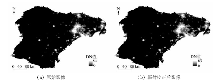
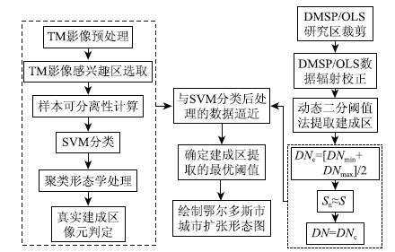
In the past decade, Ordos City of Inner Mongolia experienced rapid development of economy and rapid urban expansion, and now it is facing the stagnation of economic development and urban transformation. Urban expansion mapping and driving factor analysis at temporal and spatial scales could provide valuable information for the urbanization development planning of Ordos. Using the DMSP/OLS nighttime light(NTL)data combined with Landsat image, the authors compiled urban expansion maps for the period from 2000 to 2013. The build-up areas were extracted using a radiometric correction method based on the stable point NTLs, support vector machine (SVM) classification and thresholding techniques. The statistical analysis results show that the expansion of Ordos City can be mainly divided into three stages, and the driving factors of urban expansion could be quantitatively analyzed using the portfolio analysis method.
刘佳, 辛鑫, 刘斌, 邸凯昌, 岳宗玉, 王承安. 基于DMSP/OLS夜间灯光影像的2000—2013年鄂尔多斯市城市扩张遥感制图与驱动因子分析[J]. 国土资源遥感, 2018, 30(1): 166-172.
Jia LIU, Xin XIN, Bin LIU, Kaichang DI, Zongyu YUE, Cheng’an WANG. Urban expansion mapping and driving factor analysis of Ordos City during the period of 2000—2013 based on DMSP/OLS nighttime light data. Remote Sensing for Land & Resources, 2018, 30(1): 166-172.
Wu Y R,Zhou R P.Research on the economic transformation mode of Erdos as a city of resources[J].Journal of Inner Mongolia Normal University(Philosophy and Social Science),2015,44(5):47-49.
Wang H R,Zheng X Q,Yuan T.Overview of researches based on DMSP/OLS nighttime light data[J].Progress in Geography,2012,31(1):11-19.
[3]
Elvidge C D,Imhoff M L,Baugh K E,et al.Night-time lights of the world: 1994—1995[J].ISPRS Journal of Photogrammetry and Remote Sensing,2001:56(2):81-99.
[4]
李德仁,李熙.论夜光遥感数据挖掘[J].测绘学报,2015,44(6):591-601.
Li D R,Li X.An overview on data mining of nighttime light remote sensing[J].Acta Geodaetica et Cartographica Sinica,2015,44(6):591-601.
Fan J F,Ma T,Zhou C H,et al.Changes in spatial patterns of urban landscape in Bohai Rim from 1992 to 2010 using DMSP-OLS data[J].Journal of Geo-Information Science,2013,15(2):280-288.
[6]
Zhou Y Y,Smith S J,Elvidge C D,et al.A cluster-based method to map urban area from DMSP/OLS nightlights[J].Remote Sensing of Environment,2014,147:173-185.
Wang X H,Xiao P F,Feng X Z,et al.Extraction of large-scale urban area information in China using DMSP/OLS nighttime light data[J].Remote Sensing for Land and Resources,2013,25(3):159-164.doi:10.6046/gtzyyg.2013.03.26.
Yang Y,He C Y,Zhao Y Y,et al.Research on the layered threshold method for extracting urban land using the DMSP/OLS stable nighttime light data[J].Journal of Image and Graphics,2011,16(4):666-673.
Zhu K W,Li Y C,Liu C X,et al.The research of extraction method for build-up areas in county scale based on DMSP/OLS nighttime lights data:A case study of Chongqing[J].Journal of Chongqing Normal University(Natural Science),2015,32(6):61-67.
[11]
Elvidge C D,Ziskin D,Baugh K E,et al.A fifteen year record of global natural gas flaring derived from satellite data[J].Energies,2009,2(3):595-622.
[12]
Liu Z F,He C Y,Zhang Q F,et al.Extracting the dynamics of urban expansion in China using DMSP-OLS nighttime light data from 1992 to 2008[J].Landscape and Urban Planning,2012,106(1):62-72.
Zou J G,Chen Y H,Tian J,et al.Construction of the calibration model for DMSP/OLS nighttime light images based on ArcGIS[J].Journal of Geomatics,2014,39(4):33-37.
Liu B,Di K C,Xin X,et al. Night lamplight image interaction radiation correction method based on stable mapping points:China,CN201610115608.8[P/OL].2015-05-04[2016-07-21]..
Zhang X L,Zhang S W,Li Y,et al.Spatial expansion of urban land use and its driving forces in Harbin City over the past 30 years[J].Resources Science,2007,29(5):157-163.
Chen Z,Hu D Y,Zeng W H,et al.TM image and nighttime light data to monitoring regional urban expansion:A case study of Zhejiang Province[J].Remote Sensing for Land and Resources,2014,26(1):83-89.doi:10.6046/gtzyyg.2014.01.05.
[17]
刘婷婷. 城市用地空间扩张特征与机理探究[J].科技展望,2015,25(25):226-227.
Liu T T.Urban land use spatial expansion characteristic and mechanism[J].Science and Technology,2015,25(25):226-227.
Xu M J,Chen L,Liu H J,et al.Pattern and process of urbanization in the Yangtze Delta based on DMSP/OLS data[J].Remote Sensing for Land and Resources,2011,23(3):106-112.doi:10.6046/gtzyyg.2011.03.18.
Li Z G,Hu D Y,Li J H,et al.Simulation and spatialization of GDP in poverty areas based on night light imagery[J].Remote Sensing for Land and Resources,2016,28(2):168-174.doi:10.6046/gtzyyg.2016.02.26.
[20]
张文彤,闫洁.SPSS统计分析基础教程[M].北京:高等教育出版社,2004.
Zhang W T,Yan J.Basic Tutorial of SPSS Statistical Analysis[M].Beijing:Higher Education Press,2004.
 2018, Vol. 30
  ), 辛鑫1, 刘斌1(