Please wait a minute...
 
国土资源遥感  2018, Vol. 30 Issue (4): 156-162    DOI: 10.6046/gtzyyg.2018.04.23
     本期目录 | 过刊浏览 | 高级检索 |
老挝沙湾水经济区土地利用适宜性评价
黄巧1, 彭玉玲1(), 秦文杰2
1. 武汉工程大学土木工程与建筑学院,武汉 430073
2. 中国电建集团昆明勘测设计研究院有限公司,昆明 650000
Research on land use suitability evaluation: A case study of Savan water economic zone in Laos
Qiao HUANG1, Yuling PENG1(), Wenjie QIN2
1. School of Civil Engineering and Architecture, Wuhan University of Technology, Wuhan 430073, China
2. Kunming Engineering Corporation Limited, Power China, Kunming 650000, China
全文: PDF(3140 KB)   HTML  
输出: BibTeX | EndNote (RIS)      
摘要 

基于老挝沙湾水经济区的自然、社会、经济发展状况和土地利用现状,将层次分析法、特尔菲法和ArcGIS地理空间分析技术相结合,对研究区农业用地、林业用地和建设用地的适宜性进行评价。通过单因子适宜性和综合适宜性评价,提出不同区域的土地利用空间优化配置方向。研究结果表明,农业用地主要适宜分布在研究区西侧湄公河沿岸土壤较肥沃的地区; 林业用地适宜分布在研究区北部及东南山区; 建设用地适宜分布在沙湾水经济区西南部基础设施条件较好且地形较平坦的地区。本研究为老挝沙湾水经济区土地利用提供了一定的数据支持,同时能够为东南亚同类地区的相关研究提供借鉴和参考。

服务
把本文推荐给朋友
加入引用管理器
E-mail Alert
RSS
作者相关文章
黄巧
彭玉玲
秦文杰
关键词 土地利用适宜性评价GIS层次分析法特尔菲法老挝沙湾水经济区    
Abstract

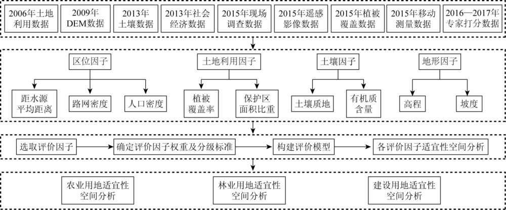
In view of the situation of the natural condition, social environment, economic development, and land use status in Savan water economic zone in Laos, a land use suitability evaluation was carried out in this paper. The suitability of the agricultural land, forest land, and construction land in the study area was evaluated by integratedly using the analytic hierarchy process method, Delphi method, and ArcGIS spatial analysis technology. Through the evaluation of single-factor suitability and comprehensive suitability, the spatial optimal allocation direction of land use was proposed. The results show that it is suitable to allocate agricultural land in fertile regions along the Mekong River which is located in the west of the study area. The forest land is suitable to be allocated in the northern and southeastern mountainous regions of the study area. The construction land is suitable to be allocated in the flat regions with well-developed infrastructures, which are located in the southwest of Savan water economic zone. This study can provide data support for the land use allocation in Savan water economic zone, Laos. Furthermore, the research findings also provide experience and references for land use allocation in similar regions in Southeast Asia.

Key wordsland use suitability evaluation    GIS    analytic hierarchy process (AHP) method    Delphi method    Savan water economic zone in Laos
收稿日期: 2017-06-05      出版日期: 2018-12-07
:  F301.2  
基金资助:湖北省教育厅科学技术研究项目“城乡土地资源多尺度优化配置方法研究”(B2018053);武汉工程大学科学研究基金项目“土地资源多尺度优化配置研究”共同资助(K201730)
通讯作者: 彭玉玲
作者简介: 黄巧(1993-),女,本科,主要从事城乡规划研究。Email: 464947235@qq.com
引用本文:   
黄巧, 彭玉玲, 秦文杰. 老挝沙湾水经济区土地利用适宜性评价[J]. 国土资源遥感, 2018, 30(4): 156-162.
Qiao HUANG, Yuling PENG, Wenjie QIN. Research on land use suitability evaluation: A case study of Savan water economic zone in Laos. Remote Sensing for Land & Resources, 2018, 30(4): 156-162.
链接本文:  
https://www.gtzyyg.com/CN/10.6046/gtzyyg.2018.04.23      或      https://www.gtzyyg.com/CN/Y2018/V30/I4/156
Fig.1  研究区位置示意图
Fig.2  土地利用适宜性评价技术路线
评价因子 适宜性等级
一级 一级权重 二级 二级权重 一等 二等 三等 四等
地形因子 0.15 高程/km 0.29 [0,0.2) [0.2,0.4) [0.4,0.8) [0.8,2.3]
坡度/(°) 0.71 [0,5) [5,10) [10,15) [15,90]
土壤因子 0.41 土壤质地 0.40 砂质黏土、壤土 砂质壤土 轻质黏土 水域(无土)
有机质含量/% 0.60 [1.2,1.7] [1.0,1.2) [0.9,1.0) [0,0.9)
区位因子 0.23 距水源平均距离/km 0.46 [0,5) [5,10) [10,15) [15,45]
路网密度/(km·km-2) 0.36 [1.0,72.7) [0.5,1.0) [0.1,0.5) [0,0.1)
人口密度(人·km-2) 0.18 [80,223] [50,80) [20,50) [0,20)
土地利用因子 0.21 植被覆盖率 0.43 [0,0.5) [0.5,0.6) [0.6,0.8) [0.8,1.00)
保护区面积比重/% 0.57 0 (0,10] (10,100) 100
Tab. 1  农业用地适宜性评价因子权重及评价等级划分
评价因子 适宜性等级
一级 一级权重 二级 二级权重 一等 二等 三等 四等
地形因子 0.11 高程/km 0.34 [0,0.2) [0.2,0.4) [0.4,1.0) [1.0,2.3]
坡度/(°) 0.66 [0,10) [10,15) [15,25) [25,90]
土壤因子 0.36 土壤质地 0.38 壤土 砂质黏土、砂质壤土 轻质黏土 水域(无土)
有机质含量/% 0.62 [1.2,1.7] [1.0,1.2) [0.9,1.0) [0,0.9)
区位因子 0.23 距水源平均距离/km 0.44 [0,10) [10,20) [20,30) [30,45]
路网密度/(km·km-2) 0.37 [0,0.2) [0.2,1.0) [1.0,5.0) [5.0,72.7]
人口密度/(人·km-2) 0.19 [0,20) [20,50) [50,100) [100,223]
土地利用因子 0.30 植被覆盖率 0.27 [0.7,1.0] [0.6,0.7) [0.5,0.6) [0,0.5)
保护区面积比重/% 0.73 (50,100] (10,50] (0,10] 0
Tab.2  林业用地适宜性评价因子权重及评价等级划分
评价因子 适宜性等级
一级 一级权重 二级 二级权重 一等 二等 三等 四等
地形因子 0.33 高程/km 0.35 [0,0.2) [0.2,0.4) [0.4,0.6) [0.6,2.3]
坡度/(°) 0.65 [0,5) [5,8) [8,10) [10,90]
区位因子 0.48 距水源平均距离/km 0.16 [0,5) [5,10) [10,15) [15,45]
路网密度/(km·km-2) 0.36 [5.0,72.7] [1.0,5.0) [0.2,1.0) [0,0.2)
人口密度/(人·km-2) 0.48 [100,223] [50,100) [20,50) [0,20)
土地利用因子 0.19 植被覆盖率 0.32 [0,0.5) [0.5,0.6) [0.6,0.8) [0.8,1.0]
保护区面积比重/% 0.68 0 (0,10] (10,50] (50,100]
Tab.3  建设用地适宜性评价因子权重及评价等级划分
等级 适宜性 农业用地 林业用地 建设用地
一等 高度适宜 6 024.75 15 669.48 9 527.94
二等 中度适宜 12 866.52 15 227.86 6 876.66
三等 勉强适宜 11 618.57 5 874.50 7 665.32
四等 不适宜 7 553.76 1 291.75 13 993.68
Tab.4  农业用地、林业用地和建设用地适宜性评价结果统计
Fig.3  研究区农业用地空间适宜性分布
Fig.4  研究区林业用地空间适宜性分布
Fig.5  研究区建设用地空间适宜性分布
[1] 焦胜, 李振民, 高青 , 等. 景观连通性理论在城市土地适宜性评价与优化方法中的应用[J]. 地理研究, 2013,32(4):720-730.
doi: 10.11821/yj2013040015
Jiao S, Li Z M, Gao Q , et al. The application of landscape connectivity theory in urban ecology suitability assessment and optimization[J]. Geographical Research, 2013,32(4):720-730.
[2] Shi D . Land reclamation suitability evaluation based on the limit method[J]. Applied Mechanics and Materials, 2013,253:1069-1074.
doi: 10.4028/www.scientific.net/AMM.253-255.1069
[3] Gong J, Liu Y, Chen W . Land suitability evaluation for development using a matter-element model:A case study in Zengcheng,Guangzhou,China[J]. Land Use Policy, 2012,29(2):464-472.
doi: 10.1016/j.landusepol.2011.09.005
[4] 李红波, 张慧, 赵俊三 , 等. 基于元胞生态位适宜度模型的低丘缓坡土地开发建设适宜性评价[J]. 中国土地科学, 2014,28(6):23-29,97.
doi: 10.3969/j.issn.1001-8158.2014.06.004
Li H B, Zhang H, Zhao J S , et al. Evaluation on land suitability for development and construction in low hill and gentle slope area based on CA-niche-suitability model[J]. China Land Sciences, 2014,28(6):23-29,97.
[5] 陈应跃, 甘淑, 田禹东 , 等. 山区土地评价的GIS空间分析建模研究[J]. 国土资源遥感, 2015,27(2):196-200.doi: 10.6046/gtzyyg.2015.02.30.
doi: 10.6046/gtzyyg.2015.02.30
Chen Y Y, Gan S, Tian Y D , et al. GIS spatial modeling in mountainous land evaluation[J]. Remote Sensing for Land and Resources, 2015,27(2):196-200.doi: 10.6046/gtzyyg.2015.02.30.
[6] 彭玉玲, 林爱文, 王珂 , 等. GIS支持下的工矿废弃地复垦利用方案决策研究——以湖北省黄石市阳新县七约山矿区为例[J]. 水土保持通报, 2015,35(2):297-301.
Peng Y L, Lin A W, Wang K , et al. GIS-based program decision-making in reclamation and utilization of industrial and mining wasteland:A case study at Qiyueshan mining area of Yangxin County,Huangshi City,Hubei Province[J]. Bulletin of Soil and Water Conservation, 2015,35(2):297-301.
[7] 彭玉玲, 林爱文, 王珂 , 等. 资源枯竭型城市的工矿废弃地复垦利用综合效益评价——以黄石市七约山矿区为例[J]. 国土资源遥感, 2015,27(3):161-166.doi: 10.6046/gtzyyg.2015.03.25.
doi: 10.6046/gtzyyg.2015.03.25
Peng Y L, Lin A W, Wang K , et al. Comprehensive benefits evaluation of mining wasteland reclamation and utilization in resource-exhausted cities:A case study of the Qiyueshan mining area,Huangshi City[J]. Remote Sensing for Land and Resources, 2015,27(3):161-166.doi: 10.6046/gtzyyg.2015.03.25.
[8] 娄胜霞 . 基于GIS技术的人居环境自然适宜性评价研究——以遵义市为例[J]. 经济地理, 2011,31(8):128-133.
Lou S X . Evaluation of natural suitability for human settlement of Zunyi Region based on GIS[J]. Economic Geography, 2011,31(8):128-133.
[9] 袁沫汐, 彭玉玲, 林爱文 , 等. 老挝沙湾水经济区生态用地利用评价[J]. 水土保持通报, 2017,37(1):234-240.
Yuan M X, Peng Y L, Lin A W , et al. Evaluation on ecological land use in Savan water economic zones of Laos[J]. Bulletin of Soil and Water Conservation, 2017,37(1):234-240.
[10] 林爱文, 詹璇, 彭玉玲 , 等. 大湄公河次区域土地利用功能分区研究——以老挝中部地区为例[J]. 测绘与空间地理信息, 2016,( 11):1-5.
Lin A W, Zhan X, Peng Y L , et al. Study on functional zoning of land use in the Greater Mekong Sub-region:A case study of central Laos[J]. Geomatics and Spatial Information Technology, 2016,39(11):1-5.
[11] 温华特 . 城市建设用地适宜性评价研究——以金华市区为例[D]. 杭州:浙江大学, 2006.
Wen H T . Study on Urban Constructive Land Suitability Evaluation:Take Jinhua for Example[D]. Hangzhou:Zhejiang University, 2006.
[12] 张紫昭, 郭瑞清, 周天生 , 等. 新疆煤矿土地复垦为草地的适宜性评价方法与应用[J]. 农业工程学报, 2015,31(11):278-286.
doi: 10.11975/j.issn.1002-6819.2015.11.040
Zhang Z Z, Guo R Q, Zhou T S , et al. Suitability evaluation method and application for land reclamation to grassland in Xinjiang coal mines[J]. Transactions of the Chinese Society of Agricultural Engineering, 2015,31(11):278-286.
[13] 李伟芳, 俞腾, 李加林 , 等. 海岸带土地利用适宜性评价——以杭州湾南岸为例[J]. 地理研究, 2015,34(4):701-710.
doi: 10.11821/dlyj201504009
Li W F, Yu T, Li J L , et al. Suitability evaluation of land use in coastal zones:A case study in southern Hangzhou Bay[J]. Geographical Research, 2015,34(4):701-710.
[14] 刘焱序, 王仰麟, 彭建 , 等. 耦合恢复力的林区土地生态适宜性评价——以吉林省汪清县为例[J]. 地理学报, 2015,70(3):476-487.
doi: 10.11821/dlxb201503010
Liu Y X, Wang Y L, Peng J , et al. Land ecological suitability assessment for forest coupled with the resilience perspective:A case study in Wangqing County,Jilin Province,China[J]. Acta Geographica Sinica, 2015,70(3):476-487.
[15] 刘军, 詹然, 孙蔚 . 基于GIS的天津市滨海新区耕地适宜性评价[J]. 国土资源遥感, 2016,28(3):160-165.doi: 10.6046/gtzyyg.2016.03.25.
doi: 10.6046/gtzyyg.2016.03.25
Liu J, Zhan R, Sun W . Evaluation of cultivated land suitability for Binhai New Area of Tianjin based on GIS[J]. Remote Sensing for Land and Resources, 2016,28(3):160-165.doi: 10.6046/gtzyyg.2016.03.25.
[16] 金志丰, 陈雯, 孙伟 , 等. 基于土地开发适宜性分区的土地空间配置——以宿迁市区为例[J]. 中国土地科学, 2008,22(9):43-50.
doi: 10.3969/j.issn.1001-8158.2008.09.008
Jin Z F, Chen W, Sun W , et al. Spatial allocation of land use based on regionalization by land development suitability:A case of urban area of Suqian City[J]. China Land Science, 2008,22(9):43-50.
[1] 武艺杰, 孔雪松. 江苏省“生态-农业-建设”用地空间格局模拟及发展模式选择[J]. 自然资源遥感, 2022, 34(1): 238-248.
[2] 李东, 唐诚, 邹涛, 侯西勇. 近海人工鱼礁水下物理状态探测与评估[J]. 自然资源遥感, 2022, 34(1): 27-33.
[3] 宋仁波, 朱瑜馨, 郭仁杰, 赵鹏飞, 赵珂馨, 朱洁, 陈颖. 基于多源数据集成的城市建筑物三维建模方法[J]. 自然资源遥感, 2022, 34(1): 93-105.
[4] 王爽, 张磊, 张俊勇, 王一乐. GIS在全民健身中的应用特征研究[J]. 自然资源遥感, 2021, 33(4): 265-271.
[5] 赵龙贤, 代晶晶, 赵元艺, 姜琪, 刘婷玥, 傅明海. 基于RS和GIS技术的西藏多龙矿集区矿山选址研究[J]. 国土资源遥感, 2021, 33(2): 182-191.
[6] 姚昆, 张存杰, 何磊, 李玉霞, 李小菊. 雅砻江中上游流域生态环境脆弱性动态评价及预测[J]. 国土资源遥感, 2020, 32(4): 199-208.
[7] 桑潇, 国巧真, 乔悦, 吴欢欢, 臧金龙. 基于多源数据的山西省长治市宜居性研究[J]. 国土资源遥感, 2020, 32(3): 200-207.
[8] 王永全, 李清泉, 汪驰升, 朱家松, 王新雨. 基于系留无人机的应急测绘技术应用[J]. 国土资源遥感, 2020, 32(1): 1-6.
[9] 宋仁波, 朱瑜馨, 丁上珊, 贺巧宁, 王细元, 王月香. 基于GIS空间分析的任意多边形骨架线自动提取方法[J]. 国土资源遥感, 2020, 32(1): 51-59.
[10] 施益强, 邓秋琴, 吴君, 王坚. 厦门市MODIS气溶胶光学厚度与空气质量指数的回归分析[J]. 国土资源遥感, 2020, 32(1): 106-114.
[11] 赵玉灵. 基于层次分析法的矿山环境评价方法研究——以海南岛为例[J]. 国土资源遥感, 2020, 32(1): 148-153.
[12] 梅昭容, 李云驹, 康翔, 魏善宝, 潘剑君. 基于移动窗口分析法的矿区景观格局时空演变研究[J]. 国土资源遥感, 2019, 31(4): 60-68.
[13] 安全, 贺中华, 赵翠薇, 梁虹, 焦树林, 杨朝晖. 基于地貌视角的喀斯特流域水系分维估算方法适应性分析[J]. 国土资源遥感, 2019, 31(4): 104-111.
[14] 张晓东, 刘湘南, 赵志鹏, 武丹, 吴文忠, 褚小东. 基于层次分析法的盐池县地质灾害危险性评价[J]. 国土资源遥感, 2019, 31(3): 183-192.
[15] 陈俊, 沈润平, 李博伦, 遆超普, 颜晓元, 周旻悦, 王绍武. 基于Logistic回归分析的塑料大棚遥感指数构建[J]. 国土资源遥感, 2019, 31(3): 43-50.
Viewed
Full text


Abstract

Cited

  Shared   
  Discussed   
京ICP备05055290号-2
版权所有 © 2015 《自然资源遥感》编辑部
地址:北京学院路31号中国国土资源航空物探遥感中心 邮编:100083
电话:010-62060291/62060292 E-mail:zrzyyg@163.com
本系统由北京玛格泰克科技发展有限公司设计开发