An improved method for extracting alteration related to the ductile shear zone type gold deposits using ASTER data
Jianyu LIU1,2, Ling CHEN2(), Wei LI2, Genhou WANG1, Bo WANG1
1.School of Earth Science and Resources, China University of Geosciences(Beijing), Beijing 100083, China 2.China Aero Geophysical Survey and Remote Sensing Center for Natural Resources, Beijing 100083, China
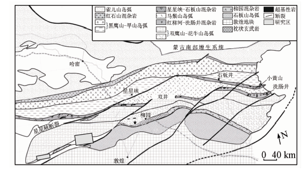
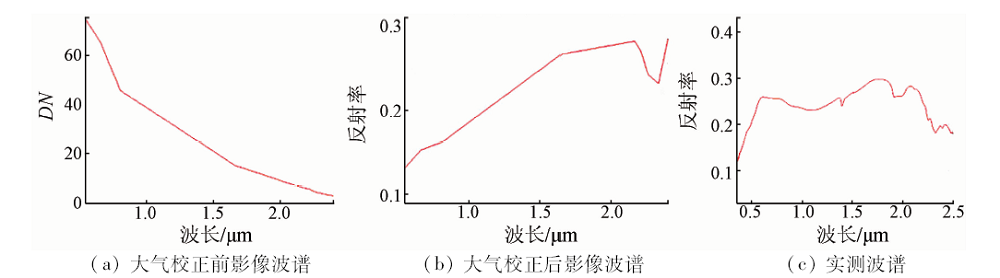
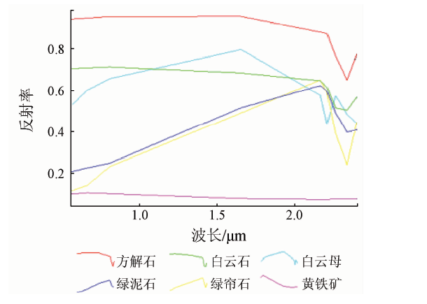
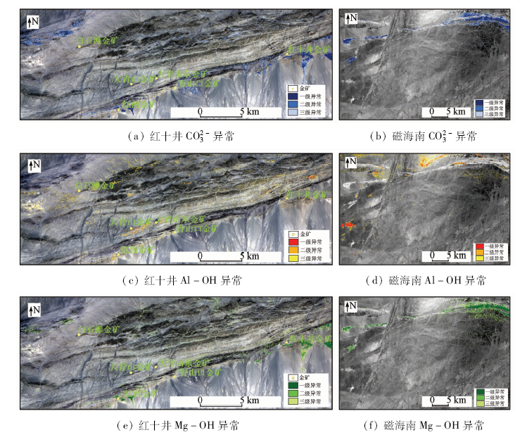
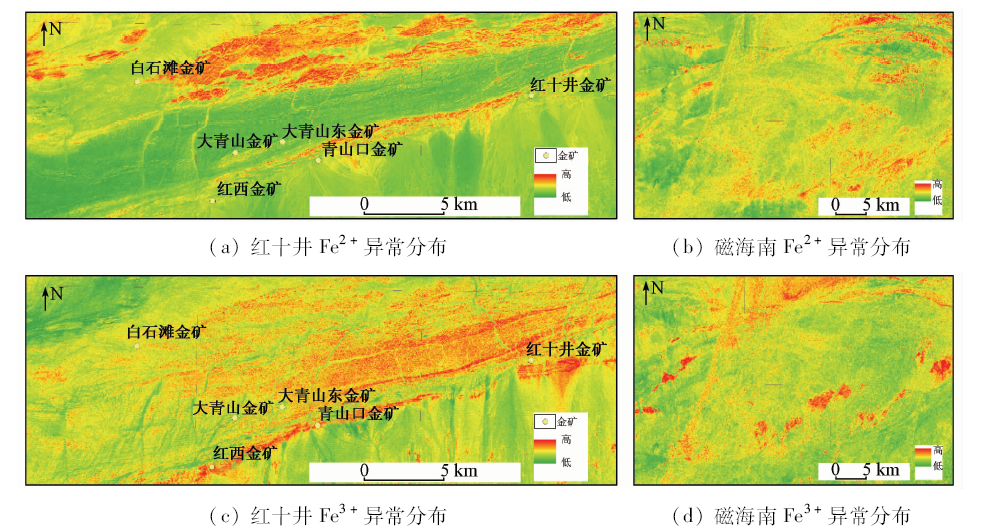
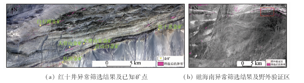
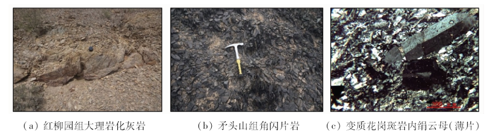
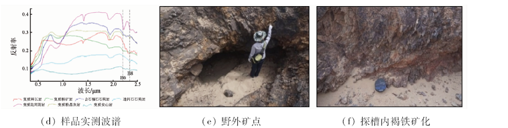
The Beishan rift is an important metallic zone in China. The principal analysis component (PCA) technique and band ratio were used to extract alteration information related to gold deposits in the study areas in Hongshijing region and south of Cihai region lying in the west of Beishan rift. As a result of regional metamorphism, the alteration zones extracted by PCA and band ratios contain a great deal of interference information. With the method proposed in this study, most useless alteration information was eliminated and the gold deposits were located at or near the selected alteration areas in Hongshijing region. To prove the capability of this method, the authors validated the selected alteration areas south of Cihai region by fieldwork and found two gold ore spots. It is concluded that this method is effective in eliminating useless alteration information and thus is recommended for application in similar geological settings in Beishan rift.
刘建宇, 陈玲, 李伟, 王根厚, 王博. 基于ASTER数据韧性剪切带型金矿蚀变信息提取方法优化[J]. 国土资源遥感, 2019, 31(1): 229-236.
Jianyu LIU, Ling CHEN, Wei LI, Genhou WANG, Bo WANG. An improved method for extracting alteration related to the ductile shear zone type gold deposits using ASTER data. Remote Sensing for Land & Resources, 2019, 31(1): 229-236.
Xiao W J, Zhang L C, Qin K Z , et al. Paleozoic accretionary and collisional tectonics of the eastern Tianshan (China):Implications for the continental growth of central Asia[J]. American Journal of Science, 2004,304(4):370-395.
doi: 10.1144/0016-764903-165
[2]
Xiao W J, Mao Q G, Windley B F , et al. Paleozoic multiple accretionary and collisional processes of the Beishan orogenic collage[J]. American Journal of Science, 2010,310(10):1553-1594.
doi: 10.2475/10.2010.12]
Ding J H, Xing S W, Xiao K Y , et al. Geological characteristics and resource potential analysis of the Dongtianshan-Beishan Cu-Ni-Au-Pb-Zn metallogenic belts[J]. Acta Geologica Sinica, 2016,90(7):1392-1412.
[4]
Chen B L, Wu G G, Ye D J , et al. Analysis of the ore-controlling structure of ductile shear zone type gold deposit in southern Beishan Area,Gansu,Northwest China[J]. Journal of China University of Geosciences, 2007,18(1):30-38.
doi: 10.1016/S1002-0705(07)60016-8
Chen B L, Wu G G, Ye D J , et al. Mode of occurrence of gold and characteristics of gold minerals in gold deposits,Beishan Area,Gansu[J]. Acta Mineralogica Sinica, 2000,20(3):242-249.
Wang Z Z, An G B . Ore controlling factors and minerogenic prognosis of western metallogenic belt of south belt of Beishan,Gansu[J]. Xinjiang Geology, 2007,25(3):307-312.
Chen B L . A discussion on origin of Jinwozi ductile shear zone type gold deposit in Beishan Area of Gansu and Xinjiang[J]. Mineral Deposits, 2010,29(6):972-982.
He G, Gu X X, Zhang Y M , et al. Geological characteristics and genesis of Daqingshan gold deposit in Beishan Area,Xinjiang[J]. Mineral Deposits. 2014,33(s1):89-90.
[10]
Loughlin W P . Principal component analysis for alteration mapping[J]. Photogrammetric Engineering and Remote Sensing, 1991,57(9):1163-1169.
[11]
Crosta A P, De Souza Filho C R, Azevedo F, et al. Targeting key alteration minerals in epithermal deposits in Patagonia,Argentina,using ASTER imagery and principal component analysis[J]. International Journal of Remote sensing, 2003,24(21):4233-4240.
doi: 10.1080/0143116031000152291
[12]
Gabr S, Ghulam A, Kusky T . Detecting areas of high-potential gold mineralization using ASTER data[J]. Ore Geology Reviews, 2010,38(1-2):59-69.
doi: 10.1016/j.oregeorev.2010.05.007
[13]
Pournamdari M, Hashim M . Detection of chromite bearing mineralized zones in Abdasht ophiolite complex using ASTER and ETM+ remote sensing data[J]. Arabian Journal of Geosciences, 2014,7(5):1973-1983.
doi: 10.1007/s12517-013-0927-0
[14]
Rajendran S, Nasir S, Kusky T M , et al. Detection of hydrothermal mineralized zones associated with listwaenites in central Oman using ASTER data[J]. Ore Geology Reviews, 2013,53(8):470-488.
doi: 10.1016/j.oregeorev.2013.02.008
[15]
Azizi H, Tarverdi M A, Akbarpour A . Extraction of hydrothermal alterations from ASTER SWIR data from east Zanjan,northern Iran[J]. Advances in Space Research, 2010,46(1):99-109.
doi: 10.1016/j.asr.2010.03.014
[16]
Zhang X, Pazner M, Duke N . Lithologic and mineral information extraction for gold exploration using ASTER data in the south Chocolate Mountains (California)[J]. ISPRS Journal of Photogrammetry and Remote Sensing, 2007,62(4):271-282.
doi: 10.1016/j.isprsjprs.2007.04.004
Wang D, Zhao Z F, Wang R X , et al. Research on enhanced extraction method for weak information of remote sensing mineralization alteration zoning:A case study of the Pulang porphyry copper deposit[J]. Remote Sensing for Land and Resources, 2015,27(2):146-153.doi: 10.6046/gtzyyg.2015.02.23.
Cheng G, Zhu J W, Mao X C . Remote sensing prospecting prediction in periphery of the Jinchuan copper-nickel deposit based on ASTER data[J]. Remote Sensing for Land and Resources, 2016,28(1):15-21.doi: 10.6046/gtzyyg.2016.01.03.
Yang J Z, Chen W, Wang H , et al. Delineation of iron formation in Wenquangou Group along Heiqia Pass in West Kunlun metallogenic belt[J]. Remote Sensing for Land and Resources, 2017,29(3):191-195.doi: 10.6046/gtzyyg.2017.03.28.
Zhang Y J, Zeng Z M, Chen W . The methods for extraction of alteration anomalies from the ETM+(TM) data and their application:Method selection and technological flow chart[J]. Remote Sensing for Land and Resources, 2003,15(2):44-49.doi: 10.6046/gtzyyg.2003.02.11.
Zhang N N, Zhou K F, Chen X , et al. A comparative study of extraction methods for alteration information based on ETM+[J]. Remote Sensing for Land and Resources, 2012,24(2):34-40.doi: 10.6046/gtzyyg.2012.02.07.
Zhang Z J, Gan F P, Li X Q , et al. The extraction of altered mineral information based on ASTER data:A case study of the Huangshan copper-nickel ore district in Hami[J]. Remote Sensing for Land and Resources, 2012,24(2):85-91.doi: 10.6046/gtzyyg.2012.02.16.
Fan S Y . Application of analytic hierarchy process method to ore-prospecting prognosis in northern Hebei[J]. Remote Sensing for Land and Resources, 2017,29(2):125-131.doi: 10.6046/gtzyyg.2017.02.18.
[24]
新疆地质矿产局. 白山幅1/20万区域地质调查报告[R]. 1979.
Xinjiang Bureau of Geology and Mineral Resources. The Report of Regional Geology Survey in Baishan Region (1:200,000)[R]. 1979.
[25]
新疆地质矿产局. 库木库都克幅1/20万区域地质调查报告[R]. 1990.
Xinjiang Bureau of Geology and Mineral Resources. The Report of Regional Geology Survey in Kumukuke Region (1:200,000)[R]. 1990.
Chen B L, Yang N, Wu G G , et al. Analysis of ore-controlling structure in ductile shear zone type gold deposits in southern Beishan Area,Gansu Province[J]. Mineral Deposits, 2002,21(2):149-158.
Chen B L, Wu G G, Yang N , et al. Baidunzi-Xiaoxugong ductile shear zone and its ore-controlling effect in the southern Beishan Area, Gansu[J]. Journal of Geomechanics, 2007,13(2):99-109.
Wang J . Geological characteristics of ductile shearing zone type Au deposits and ore-seaching direction in the south belt, Beishan Region,Gansu Province[J]. Contributions to Geology and Mineral Resources. 2005,20(z1):33-35,39.
[29]
Kalinowski A, Oliver S . ASTER Mineral Index Processing Manual[R].Remote Sensing Applications. Geoscience Australia, 2004.
[30]
Lowell J D, Guilbert J M . Lateral and vertical alteration-mineralization zoning in porphyry ore deposits[J]. Economic Geology, 1970,65(4):373-408.
doi: 10.2113/gsecongeo.65.4.373
[31]
Mars J C, Rowan L C . Regional mapping of phyllic-and argillic-altered rocks in the Zagros magmatic arc,Iran,using advanced spaceborne thermal emission and reflection radiometer (ASTER) data and logical operator algorithms[J]. Geosphere, 2006,2(3):161-186.
doi: 10.1130/GES00044.1
[32]
Zhang T B, Yi G H, Li H M , et al. Integrating data of ASTER and Landsat-8 OLI (AO) for hydrothermal alteration mineral mapping in Duolong porphyry Cu-Au deposit,Tibetan Plateau,China[J]. Remote Sensing, 2016,8(11):890.
doi: 10.3390/rs8110890
Wang H, Fan Y H, Zhang S P , et al. Delineation of Heiqia iron polymetallic mineralization zone in West Kunlun Region using high resolution remote sensing technology[J]. Geological Survey of China, 2016,3(5):13-20.
Yi H, Li J Q, Han H H , et al. Application of remote sensing in integrated survey on mineral exploration in Beketan,Altyn[J]. Geological Survey of China, 2016,3(4):1-5.
Yang J Z, Wang H Q, Chen W . Main progress and achievements of high spacial resolution remote sensing survey on west Kunlun metallorgenic belt[J]. Geological Survey of China, 2016,3(5):7-12.
Yan B K, Dong X F, Wang Z , et al. Mineral information extraction technology by airborne hyperspectral remote sensing and its application progress:An example of mineralization belts of western China[J]. Geological Survey of China, 2016,3(4):55-62.
 2019, Vol. 31
  ), 李伟2, 王根厚1, 王博1