Accurate monitoring of ecological redline areas in Nanjing City using high resolution satellite imagery
ZHANG Peng1,2,3(), LIN Cong1,2,3, DU Peijun1,2,3(), WANG Xin1,2,3, TANG Pengfei1,2,3
1. School of Geography and Ocean Science, Nanjing University, Nanjing 210023, China 2. Jiangsu Provincial Key Laboratory of Geographic Information Science and Technology, Nanjing University, Nanjing 210023, China 3. Key Laboratory for Land Satellite Remote Sensing Applications of Ministry of Natural Resources, Nanjing 210023, China
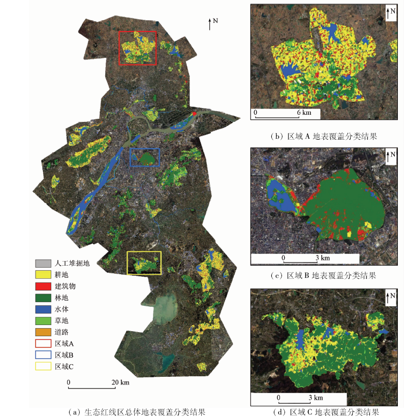
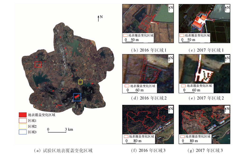
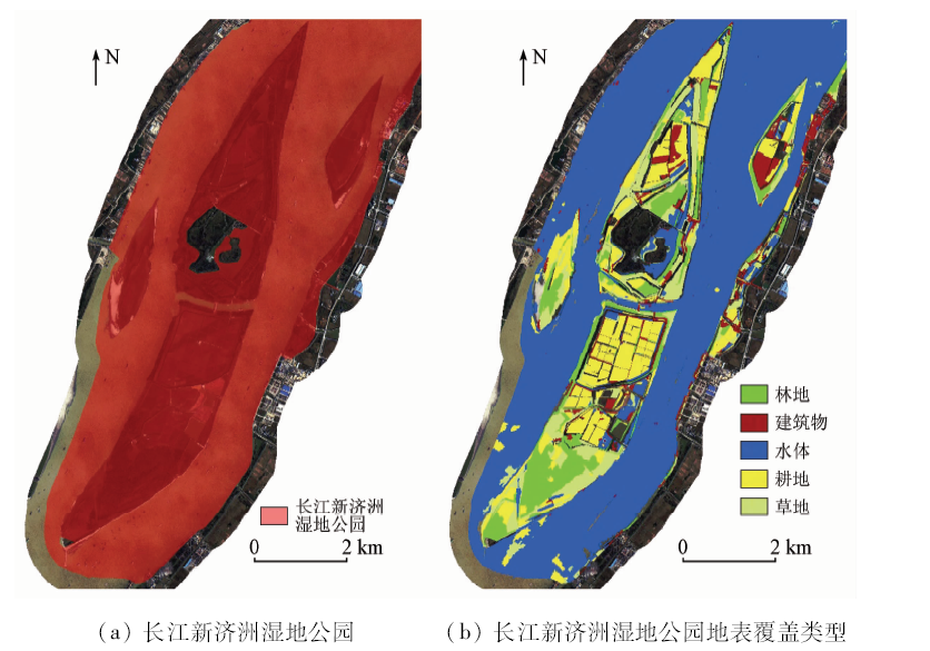
The rapid development of China’s industrialization and urbanization has brought about a series of ecological and environmental problems. China has proposed a new ecological redline policy (ERP), which plays an important role in protecting natural ecosystems and guaranteeing the national ecological safety. For accurate monitoring of ecological redline areas (ERAs), the high temporal-and-spatial resolution BJ-2 satellite imagery was used for land cover classification of the ERAs of Nanjing. Given the characteristics of BJ-2 satellite imagery, a workflow from data preprocessing to object-based land cover classification was established. The overall accuracy of the classification can reach to 91.65%. It is shown that the ERAs of Nanjing is mainly composed of three kinds of land cover types: forest, cultivated land and water, which occupy 33%, 21% and 25% of the study area respectively. In addition, buildings and artificial pile digging account for 6% and 2%, which can represent human influence to a certain extent. The experimental results show that the multi-temporal BJ-2 imagery can be used to detect the detailed changes of land cover that are difficult to identify in low- and medium-resolution images, and achieve the purpose of dynamic and accurate monitoring of ERAs.
张鹏, 林聪, 杜培军, 王欣, 唐鹏飞. 南京市生态红线区高分辨率遥感精准监测方法与应用[J]. 国土资源遥感, 2020, 32(3): 157-164.
ZHANG Peng, LIN Cong, DU Peijun, WANG Xin, TANG Pengfei. Accurate monitoring of ecological redline areas in Nanjing City using high resolution satellite imagery. Remote Sensing for Land & Resources, 2020, 32(3): 157-164.
Lin Y, Fan J F, Wen Q, et al. Primary exploration of ecological theories and technologies for delineation of ecological redline zones[J]. Acta Ecologica Sinica, 2016,36(5):1244-1252.
[2]
Kennedy R E, Yang Z Q, Cohen W B. Detecting trends in forest disturbance and recovery using yearly landsat time series:1.LandTrendr-temporal segmentation algorithms[J]. Remote Sensing of Environment, 2010,114(12):2897-2910.
doi: 10.1016/j.rse.2010.07.008
[3]
Cohen W B, Yang Z Q, Kennedy R E, et al. A LandTrendr multispectral ensemble for forest disturbance detection[J]. Remote Sensing of Environment, 2018,205:131-140.
doi: 10.1016/j.rse.2017.11.015
[4]
Verbesselt J, Zeileis A, Herold M. Near real-time disturbance detection using satellite image time series[J]. Remote Sensing of Environment, 2012,123(123):98-108.
doi: 10.1016/j.rse.2012.02.022
[5]
Huang C Q, Goward S N, Masek J G, et al. An automated approach for reconstructing recent forest disturbance history using dense Landsat time series stacks[J]. Remote Sensing of Environment, 2010,114(1):183-198.
doi: 10.1016/j.rse.2009.08.017
[6]
Zhu Z, Woodcock C E. Continuous change detection and classification of land cover using all available Landsat data[J]. Remote Sensing of Environment, 2014,144(1):152-171.
doi: 10.1016/j.rse.2014.01.011
[7]
Goetz S, Gross J, Hansen A, et al. Landscape conditions and trends in and around delaware water gap and upper delaware national recreation areas:Summary of findings[R].Report,NASA Applications Program,NPS I&M Program, 2011.
Yan E P, Lin H, Dang Y F, et al. The spatiotemporal changes of vegetation cover in Beijing-Tianjin sandstorm source control region during 2000—2012[J]. Acta Ecologica Sinica, 2014,34(17):5007-5020.
[9]
Chéret V, Denux J P. Analysis of MODIS NDVI time series to calculate indicators of mediterranean forest fire susceptibility[J]. Mapping Sciences & Remote Sensing, 2011,48(2):171-194.
[10]
徐涵秋. 水土流失区生态变化的遥感评估[J]. 农业工程学报, 2013,(7):91-97.
Xu H Q. Assessment of ecological change in soil loss area using remote sensing technology[J]. Transactions of the Chinese Society of Agricultural Engineering, 2013,29(7):91-97.
Sabit M, Nasirdin N, Mamut A. Analysis on the change of land use/cover ecological service value in Tomur National Nature Reserve[J]. Geographical Research, 2016,35(11):2116-2124.
State Council of China.Opinions of the state council on strengthening the key work of environmental protection[EB/OL].(2011-10-20)[2019-10-17]. http://www.gov.cn/zhuanti/2015-06/13/content_2878991.htm.
[13]
Ma L, Li M C, Ma X X, et al. A review of supervised object-based land-cover image classification[J]. ISPRS Journal of Photogrammetry & Remote Sensing, 2017,130:277-293.
Chen L, Liang S N, Zhou Y, et al. Potential of applying domestic high-resolution remote sensing data to geological survey in high altitudes[J]. Remote Sensing for Land and Resources, 2015,27(1):140-145.doi: 10.6046/gtzyyg.2015.01.22.
Wang Y L, Dong W H. Application of ZY1-02C remote sensing data to the investigation of geoparks:Taking Jixian County,Tianjin City for example[J]. Remote Sensing for Land and Resources, 2017,29(s1):95-100.doi: 10.6046/gtzyyg.2017.s1.16.
Du P J, Shan D D, Xia J S, et al. Monitoring and analyzing urban landscape pattern change using Beijing-1 small satellite remote sensing data:Taking the urban area of Xuzhou City as an example[J]. Journal of Geo-Information Science, 2010,12(6):855-862.
Guo H H, Wang J L, Zhou Y J, et al. The moorburn information extraction on Poyang Lake Nanji Wetland Nature Reserve area based on the object-oriented classification method[J]. Journal of Geo-Information Science, 2014,16(3):499-506.
Su W, Li J, Chen Y H, et al. Object-oriented urban land-cover classification of multi-scale image segmentation method:A case study in Kuala Lumpur City Center,Malaysia[J]. Journal of Remote Sensing, 2007,11(4):521-530.
doi: 10.11834/jrs.20070472
[19]
Blaschke T. Object based image analysis for remote sensing[J]. ISPRS Journal of Photogrammetry and Remote Sensing, 2010,65(1):2-16.
doi: 10.1016/j.isprsjprs.2009.06.004
[20]
Pande-Chhetri R, Abd-Elrahman A, Liu T, et al. Object-based classification of wetland vegetation using very high-resolution unmanned air system imagery[J]. European Journal of Remote Sensing, 2017,50(1):564-576.
doi: 10.1080/22797254.2017.1373602
Fang C Y, Wu H, Tao C H, et al. The wetland information extraction research of Nanji Wetland in Poyang Lake based on high resolution remote sensing image[J]. Journal of Geo-Information Science, 2016,18(6):847-856.
[22]
Myint S W, Gober P, Brazel A, et al. Per-pixel vs.object-based classification of urban land cover extraction using high spatial resolution imagery[J]. Remote Sensing of Environment, 2011,115(5):1145-1161.
doi: 10.1016/j.rse.2010.12.017
Tao C, Tan Y H, Cai H J, et al. Object-oriented method of hierarchical urban building extraction from high-resolution remote-sensing imagery[J]. Acta Geodaetica et Cartographica Sinica, 2010,39(1):39-45.
[24]
Li X X, Myint S W, Zhang Y J, et al. Object-based land-cover classification for metropolitan Phoenix,Arizona,using aerial photography[J]. International Journal of Applied Earth Observation and Geoinformation, 2014,33(1):321-330.
doi: 10.1016/j.jag.2014.04.018
[25]
Duro D C, Franklin S E, Dubé M G. A comparison of pixel-based and object-based image analysis with selected machine learning algorithms for the classification of agricultural landscapes using SPOT-5 HRG imagery[J]. Remote Sensing of Environment, 2012,118:259-272.
doi: 10.1016/j.rse.2011.11.020
Chen Q, Chen J F. Research on the extraction method of landcover information in southern coastal land of Hangzhou Bay based on GF-1 image[J]. Journal of Natural Resources, 2015,30(2):350-360.
[27]
Dronova I, Gong P, Clinton N E, et al. Landscape analysis of wetland plant functional types:The effects of image segmentation scale,vegetation classes and classification methods[J]. Remote Sensing of Environment, 2012,12:357-369.
Bo S K, Han X C, Ding L. Automatic selection of segmentation parameters for object oriented image classification[J]. Geomatics and Information Science of Wuhan University, 2009,34(5):514-517.
[29]
Pu R, Landry S. A comparative analysis of high spatial resolution IKONOS and WorldView-2 imagery for mapping urban tree species[J]. Remote Sensing of Environment, 2012,124:516-533.
doi: 10.1016/j.rse.2012.06.011
Yang K G, Feng X Z, Xiao P F, et al. Optimal subspace ensemble with SVM for hyperspectral image classification[J]. Journal of Remote Sensing, 2016,20(3):409-419.
He L M, Shen Z Q, Kong F S, et al. Study on multi-source remote sensing images classification with SVM[J]. Journal of Image and Graphics, 2007,12(4):648-654.
doi: 10.11834/jig.20070410
 2020, Vol. 32
  ), 林聪1,2,3, 杜培军1,2,3(