Study on the relationship between impervious surface coverage and artificial heat in new urban districts: A case study of Xixian New District, Shaanxi Province
1. College of Geography and Tourism, Shaanxi Normal University, Xi’an 710119, China 2. National Experimental Teaching Demonstration Center of Geography (Shaanxi Normal University), Xi’an 710119, China
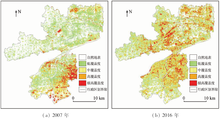
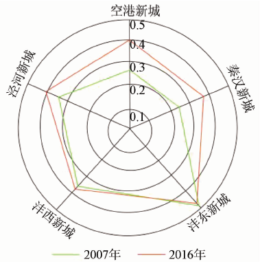
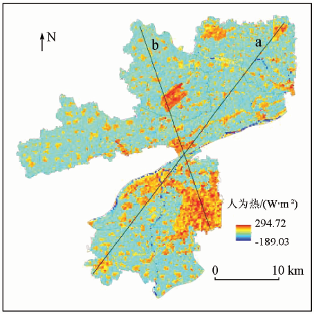
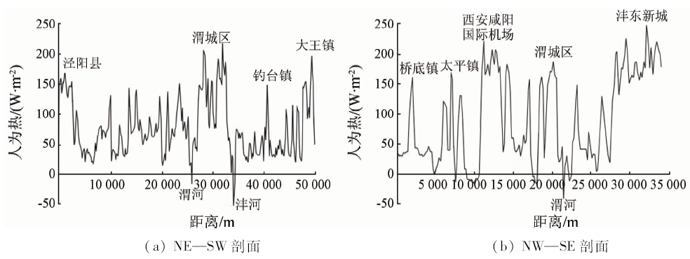
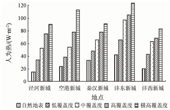
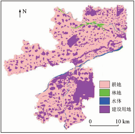
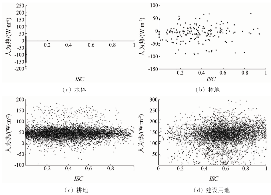
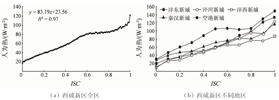
基于Landsat数据,采用线性光谱混合模型分解法提取陕西省西咸新区2007年和2016年2景影像的不透水地表盖度,利用地表能量平衡法提取同期人为热信息,并探讨二者间的关系。结果表明: ①2007—2016年间不透水面从294.93 km 2扩张至362.62 km 2,由以自然地表与低覆盖度等级占主导逐渐演变为以中、高覆盖度不透水地表盖度等级占主导; ②2016年研究区人为热在空间上区域差异显著,高值区集中分布于沣东新城中北部和空港新城西安咸阳国际机场周边,在秦汉新城中部、沣西新城北部和泾河新城部分地区有零星分布; ③各土地利用不透水地表盖度均值和人为热均值均呈现建设用地>耕地>林地>水体的特点; ④不透水盖度与人为热呈正相关,相关系数为0.97,各地区的人为热值随不透水地表盖度上升速率呈现空港新城>沣东新城>泾河新城>秦汉新城>沣西新城的规律。
Based on Landsat data, the authors extracted the impervious surface coverage of the two sceneries in Xixian New District in 2007 and 2016 by the linear spectral mixture model decomposition method, and extracted the artificial thermal information by the surface energy balance method in the same period, and investigated the relationship between them. The results are as follows: ① From 2007 to 2016, the impervious surface expanded from 294.93 km 2 to 362.62 km 2, and gradually changed from natural surface and low coverage to medium and high coverage. ② In 2016, the regional differences of anthropogenic heat in the study area were significant. The high-value areas were concentrated in the north-central part of Fengdong New Town and around Xianyang International Airport of Airport New Town, and were scattered in the central part of Qinhan New Town, northern part of Fengxi New Town and part of Jinghe New Town. ③ The mean values of impervious coverage and anthropogenic thermal mean values of land use showed the tendency of construction land>cultivated land>woodland>water body. ④ There was a positive correlation between impervious coverage and artificial heat, with a correlation coefficient of 0.97. The rate of increase of artificial heat values with impervious coverage had the tendency of Airport New Town>Fengdong New Town>Jinghe New Town>Qinhan New Town>Fengxi New Town.
王茹, 张艳芳, 张洪敏, 李云. 城市新区不透水地表盖度与人为热的关系研究——以陕西省西咸新区为例[J]. 国土资源遥感, 2020, 32(1): 247-254.
Ru WANG, Yanfang ZHANG, Hongmin ZHANG, Yun LI. Study on the relationship between impervious surface coverage and artificial heat in new urban districts: A case study of Xixian New District, Shaanxi Province. Remote Sensing for Land & Resources, 2020, 32(1): 247-254.
Wang Y N, Sun R H, Chen L D . Study on the impact of vehicle emissions on microclimate in Beijing metropolis[J]. Acta Ecologica Sinica, 2017,37(3):953-959.
Ling H, Liu H Z, Sang J G , et al. Effects of urban anthropogenic heat on Beijing’s thermal environment[J]. Climate and Environment Studies, 2004,9(3):409-421.
Ji C C, Jia Y H, Li X S , et al. Estimation of vegetation coverage of Nitraria spinosa shrubs by linear/non-linear spectral hybrid model[J]. Journal of Remote Sensing, 2016,20(6):1402-1412.
Qin Z H, Li W J, Xu B , et al. Estimation of surface emissivity within TM6 band of Landsat[J]. Land and Resources Remote Sensing, 2004,16(3):28-32.doi: 10.6046/gtzyyg.2004.03.07.
Song T, Duan Z, Liu J Z , et al. Comparison of land surface temperature inversion algorithms for Landsat8 data[J]. Journal of Remote Sensing, 2015,19(3):451-464.
Wang Y D, Zhao X Y, Xu X H , et al. Remote sensing inversion analysis of surface heat flux in Nanjing area[J]. Journal of Ecology and Environment, 2016,25(4):636-646.
[15]
Bastiaanssen W G M . SEBAL-based sensible and latent heat fluxes in the irrigated Gediz Basin,Turkey[J]. Journal of hydrology, 2000,229(1):87-100.
Li B F, Chen Y N, Li W H , et al. Estimation of evapotranspiration in the main stream of Tarim River based on remote sensing and SEBAL model[J]. Journal of Geography, 2011,66(9):1230-1238.
[17]
Zhou Y, Weng Q, Gurney K R , et al. Estimation of the relationship between remotely sensed anthropogenic heat discharge and building energy use[J]. ISPRS Journal of Photogrammetry and Remote Sensing, 2012,67(none):65-72.
[18]
Kato S, Yamaguchi Y . A nalysis of urban heat-island effect using ASTER and ETM+ data:Separation of anthropo-genic heat discharge and natural heat radiation from sensible heat flux[J]. Remote Sensing of Environment, 2005,99(1):44-54.
[19]
Nishida K, Nemani R R, Running S W , et al. An operational remote sensing algorithm of land surface evaporation[J]. Journal of Geophysical Research:Atmospheres, 2003,108(D9):1-14.
 2020, Vol. 32
  ), 张洪敏1,2, 李云1,2