1. Institute of Geographical Sciences Hebei Academy of Sciences/ Hebei Engineering Research Center for Geographic Information Application, Shijiazhaung 050011, China 2. Key Laboratory of Soil and Water Conservation and Desertification Control of Ministry of Education, College of Soil and Water Conservation,Beijimg Forestry University, Beijing 100083, China
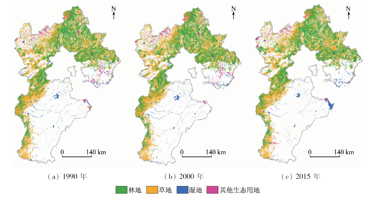
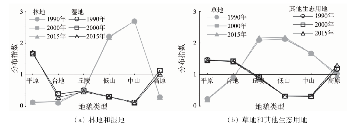
Ecological land is connected with human social development and natural ecological succession based on the inherent correlation between land use and land cover. Studying the topographical differentiation of ecological land spatial-temporal pattern in Hebei Province can provide scientific basis for the protection and optimization of ecological land in Beijing-Tianjin-Hebei region. Based on land use data of Hebei Province obtained in 1990, 2000 and 2015, the authors used GIS technology to analyze the topographical differentiation of ecological land spatial-temporal pattern in Hebei Province. The conclusions are as follows: ① The advantageous distribution topographical types of ecological land are hills, low mountain and middle mountain, while the advantageous distribution topographical types of forest are low mountain and middle mountain, the advantageous distribution topographical types of grassland are hills, low mountain and middle mountain, the advantageous distribution topographical types of wetland are plains and plateau, the advantageous distribution topographical types of other ecological land are plains, platform and plateau. ② During the study period, the forest in the platform and the other ecological land in plain, platform, low mountain and mid-mountain landform types had extremely poor spatial stability. ③ According to the land use change TUPU, the stable type is the primary land use change type, accounting for 86.75% of the whole catchment. The low mountain and middle mountain are the advantageous distribution topographical types for the stability, while the plain, platform, hill and plateau are the advantageous distribution topographical types for the prophase kind, the plain, platform and plateau are the advantageous distribution topographical types for the anaphase kind, the plain, platform and hill are the advantageous distribution topographical types for the repetitive kind, and the plain is the advantage distribution topographical type for the constant kind. The topographical differentiation of ecological land distribution, spatial stability and TUPU are significant.
Bao H S. Geomorphological types and land use of Hengxi People’s Commune in Jiangning County[J].Journal of Nanjing University(Natural Science), 1963(15):67-73.
Wang X Z, Zhang Z X, Sheng L X, et al. Land use patterns in Northeast China based on landform characteristics[J]. Chinese Journal of Ecology, 2010,29(12):2444-2451.
Zhao M, Cheng W M, Huang Kun, et al. Research on land cover change in Beijing-Tianjin-Hebei region during the last 10 years based on different geomorphic units[J]. Journal of Natural Resources, 2016,31(2):252-264.
He S W, Zhao S M, Cheng W M. Analysis of land cover change on basic geomorphic types in Shanxi Province[J]. Journal of Geo-information Science, 2016,18(2):210-219.
Han H Q, Yang G B, Zhang F T. Spatio-temporal analysis of land use changes in Guizhou Province based on landform characteristics[J]. Journal of Nanjing Forestry University(Natural Sciences Edition), 2015,39(5):99-105.
Pan F J, Wang H Z, Li R D. Fractal characteristics and change direction of land use restricted by Micro-landform of the Jianghan Plain[J]. Aeral Research Development, 2018,37(1):138-142.
Fang X, Cao J J, Na J M, et al. Spatial patterns of land use changes in different micro-geomorphic types of loess hilly area:A case study of Hechuan town in Ningxia Hui Autonomous region[J]. Geography and Geo-Information Science, 2017,33(4):113-118.
Cai G P, Zhang C Q. Temporal and spatial analysis of land use changes based on the topography[J]. Journal of Sichuan Agricultural University, 2015,33(4):392-398.
Xue Z S, Su F Z, Yang X M, et al. Dynamic change of land use in coastal zone of the pearl river estuary-with landform analysis[J]. Tropical Geography, 2012,32(4):409-415.
Wang X Q, Wang Q Q, Li H G, et al. Spatial pattern of LUCC in different micro-geomorphic types of Huanghe Kiver Delta[J]. Scientia Geographic Sintica, 2008,28(4):513-517.
Yu F, Li X B, Zhang J, et al. Study of ecological land in Cliina:Conception,classification,and spatial-temporal pattern[J]. Acta Ecologica Sinica, 2015,35(14):4931-4943.
Zhou R, Gong X J, Su H L, et al. Identification and security pattern of ecological land in Pingdingslian newly developed area[J]. Acta Ecologica Sinica, 2015,35(6):2003-2012.
Peng J, Wang A, Liu Z X, et al. Research progress and prospect on measuring urban ecological land demand[J]. Acta Georaphica Sinica, 2015,70(2):333-346.
Zhou R, Hu Y M, Wang X J, et al. Change characteristics of ecological land and its driving factors in rapidly urbanizing region[J]. Resources and Environment in the Yangtze Basin, 2015,24(6):1012-1020.
Cheng Y X, Wang H M, Liu G S, et al. Spatial layout optimization for ecological land based on minimum cumulative resistance model[J]. Transactions of the Chinese Society of Agricultural Engineering, 2016,32(16):248-257.
Zhang Qian, Gao S F, Gao C Q, et al. Ecological land of Pingdingshan city and its ecosystem services evolution over the past 20 years[J]. Ecological Science, 2018,37(3):159-168.
Wu A B, Zhao Y X. Analysis of ecological land pattern evolution and ecosystem service value in Bashang plateau[J]. Transactions of the Chinese Society of Agricultural Engineering, 2017,33(2):283-290.
Liu J Y, Kuang W H, Zhang Z X, et al. Spatiao temporal characteristics, patterns and causes of land-use changes in China since the late 1980s[J]. Journal of Geographical Sciences, 2014,69(1):3-14.
Yu H, Zeng H, Jiang Z Y. Study on distribution characteristics of landscape elements along the terrain gradient[J]. Scientia Geographica Sinica, 2001,21(1):64-69.
Gong W F, Kong D, Fan W Y, et al. Characteristic analysis of spatio-temporal pattern evolution of land use in Harbin region of Songhuajiang watershed[J]. Transactions of the Chinese Society of Agricultural Engineering, 2009,25(8):249-255.
Sun P L, Xu Y Q, Wang S. Terrain gradient effect analysis of land use change in poverty area around Beijing and Tianjin[J]. Transactions of the Chinese Society of Agricultural Engineering, 2014,30(14):277-288.
Zhang J, Ren Z Y. Spatio temporal pattern and terrain gradient effect of land use change in Qinling-Bashan mountains[J]. Transactions of the Chinese Society of Agricultural Engineering, 2016,32(14):250-257.
Li J J, Li Z M, Shi X P, et al. Spatiotemporal variations analysis for land use in Fen River Basin based on terrain gradient[J]. Transactions of the Chinese Society of Agricultural Engineering, 2016,32(7):230-236.
Jia B Q, Wang C, Ma Y F. Analysis on land use change and its driving factors in Songshan district,Chifeng City,Inner Mongolia[J]. Arid Zone Research, 2004,21(3):235-239.
 2020, Vol. 32