Remote sensing research on the spatial-temporal pattern of “cold island effect” of oasis in Jinghe River basin
WU Zhaopeng1,2(), NIU Sujuan1, MAO Min1, Yurimatih Amat1, ZHANG Jinyan1
1. College of Geographical Science and Tourism, Xinjiang Normal University, Urumqi 830054, China 2. Xinjiang Laboratory of Lake Environment and Resources in Arid Zone, Urumqi 830054, China
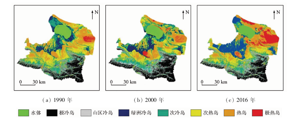
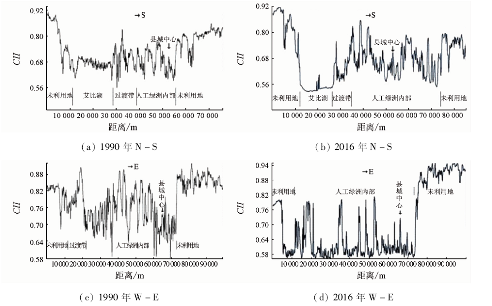
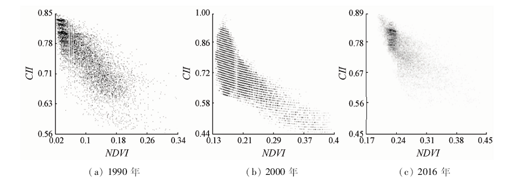
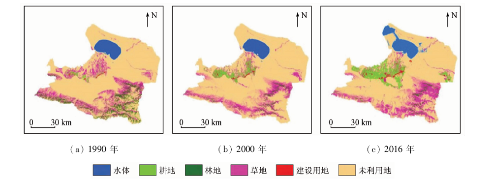
“Cold island effect” has obvious ecological significance to oasis water saving and agricultural development in arid areas. In this paper, the “cold island effect” of oasis was studied based on oasis surface temperature in Jinghe basin, which is both a national key development area and a typical ecologically fragile oasis in Xinjiang. The results are as follows: ① In the past 26 years, there was a great decrease of sub-heat island in Jinghe basin, and the oasis cold island effect showed an increasing trend; ② Relatively,the cold island effect of oasis in the research area was not obvious in 1990,but, with the increasing human activities, especially the increasing proportion of cultivated land, grassland and water since 2000, the cold island effect of oasis was more significant than the heat island effect in the study area. ③ The N-S and W-E trending profile analysis shows that the influence range of oasis cold island effect is dominated in the north-south direction; ④ The enhancement of oasis effect in the study area has a relatively consistent response with the increase of annual precipitation and temperature change,and the surface vegetation coverage is the main influencing factor of oasis cold island effect.
毋兆鹏, 牛苏娟, 毛敏, 月热买提汗·艾买提, 张金燕. 精河流域绿洲“冷岛效应”时空格局遥感研究[J]. 国土资源遥感, 2020, 32(3): 106-113.
WU Zhaopeng, NIU Sujuan, MAO Min, Yurimatih Amat, ZHANG Jinyan. Remote sensing research on the spatial-temporal pattern of “cold island effect” of oasis in Jinghe River basin. Remote Sensing for Land & Resources, 2020, 32(3): 106-113.
Su C X, Hu Y Q, Zhang Y F, et al. The microclimate character and “cold island effect” over the oasis in Hexi region[J]. Chinese Journal of Atmospheric Sciences, 1987,11(4):390-396.
doi: 10.3878/j.issn.1006-9895.1987.04.07
Yang L P, Pan X P, Liu J, et al. Spatio-temporal variation characteristics of land surface temperature and cold island effect in Ejina oasis[J]. Journal of Arid Land Resources and Environment, 2019,33(2):116-121.
Li R L, Shi Y J, Yao Y M, et al. Temporal and spatial variation of oasis cold island effect in Ganzhou district of Zhangye based on Landsat TM/ETM+[J]. Journal of Arid Land Resources and Environment, 2014,28(9):139-144.
[5]
周定文. 冷岛效应的分析解[J]. 成都气象学院学报, 1990,15(4):34-38.
Zhou D W. The analytic solution of cold island effect[J]. Journal of Chengdu University of Information Technology, 1990,15(4):34-38.
Chen J Y, Wang J M, Guang T N. An independent method to determine the surface roughness length[J]. Chinese Journal of Atmospheric Sciences, 1993,17(1):21-26.
doi: 10.3878/j.issn.1006-9895.1993.01.03
Lu S H, Chen Y C. The numerical simulation of the features of the planertary boundary layer of the oasis and the GOBI desert in the arid region[J]. Journal of Desert Research, 1995,15(2):116-123.
Zuo H C, Lyu S H, Hu Y Q, et al. Observation and numerical simulation of heterogenous underlying surface boundary layer(I):the whole physical picture of cold island effect and inverse humidity[J]. Plateau Meteorology, 2004,23(2):155-162.
Zhang Q, Zhou Y. The characteristics of budget of radiation and energy as well microclimate of Dunhuang oasis on a typical clear day in summer[J]. Chinese Journal of Plant Ecology, 2002,26(6):717-723.
Shi Q S, Xiao J D, Xiong H G, et al. Research on the cold island effect—base on the Qital oasis[J]. Journal of Xinjiang University(Natural Science Edition), 2006,23(3):334-337.
Pan J H, Zhang W Q. Remote sensing analysis of the spatial-temporal pattern of “cold island”effect of Zhangye oasis[J]. Arid zone research, 2010,27(4):481-486.
Wang L L, Liu P X, Yao Y L, et al. Spatiotemporal variation of the cold island effect and its relationship with NDVI and LUCC in Golmud oasis in the last 27 years[J]. Chinese Journal of Ecology, 2014,33(12):3339-3348.
Gao Y, Liu P X, Yao Y L, et al. Spatial-temporal characteristics and factor analysis of the cold island effect in the Shihezi oasis based on remote sensing images[J]. Journal of Natural Resources, 2015,30(8):1319-1331.
Ke L, Ye M, Ling H B, et al. Analysis of regional climate change impact on surface runoff in Jinghe river in recent forty-eight years[J]. Journal of Water Resources and Water Engineering, 2013,24(1):54-63.
Zhang F, Li Y B, Wang D F, et al. Analysis of distribution patterns and spatial variability of soil salinity affecting factors in topsoil layer of salinized soil in Jinghe oasis [J]. Journal of Ecology and rural Environment, 2018,34(1):64-73.
Qian Y B, Wu Z N, Zhang L Y, et al. Ground-surface conditions of sand-dust event occurrence and soil conservation in Aibi lake region of Xinjiang[J]. Resources Sciecnce, 2006,28(5):185-189.
Wu Z P, Wang M X, Zhao X. The changes of desertification from 1990—2011 in Jinghe watershed[J]. Journal of Arid Land Resources and Environment, 2015,29(1):192-197.
[19]
覃志豪, Li Wenjuan, Zhang Minghua, 等. 单窗算法的大气参数估计方法[J]. 国土资源遥感, 2003,56(2):37-43.doi: 10.6046/gtzyyg.2003.02.10.
Qin Z H, Li W J, Zhang M H, et al. Estimatingof the essential atmospheric parameters of mono-window algorithm for land surface temperature retrieval from Landsat TM6[J]. Remote Sensing for Land & Resources, 2003,56(2):37-43.doi: 10.6046/gtzyyg.2003.02.10.
[20]
Rozenstein O, Qin Z H, Derimian Y, et al. Derivation of land surface temperature for Landsat-8 TIRS using a split window algorithm[J]. Sensors, 2014,14(4):5768-5780.
pmid: 24670716
Dong Y, Zhang L S, Chen X G. Runoff characteristic and its responses to precipitation change in Jinge river[J]. South-to-North Water Transfers and Water Science & Technology, 2016,14(4):60-64,98.
 2020, Vol. 32
  ), 牛苏娟1, 毛敏1, 月热买提汗·艾买提1, 张金燕1