Winter wheat planting area identification and extraction based on image segmentation and NDVI time series curve classification model
Biqing WANG1, Wenquan HAN1,2(), Chi XU1,3
1. Nanjing Surveying and Mapping Research Institute Co., Ltd., Nanjing 210019, China 2. School of Transportation, Southeast University, Nanjing 210096, China 3. College of Earth Sciences and Engineering, Hohai University, Nanjing 211100, China
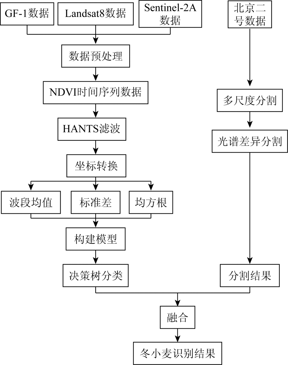
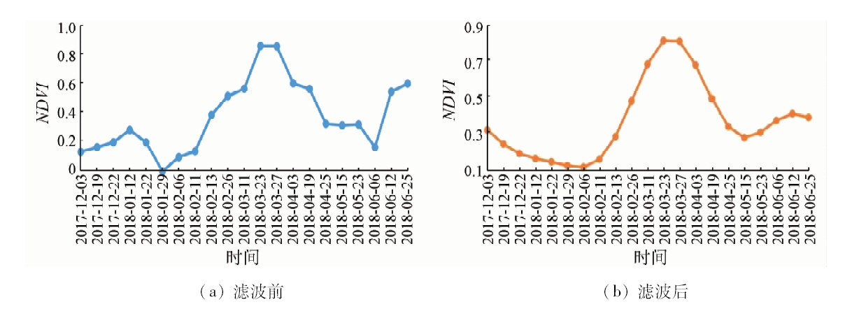
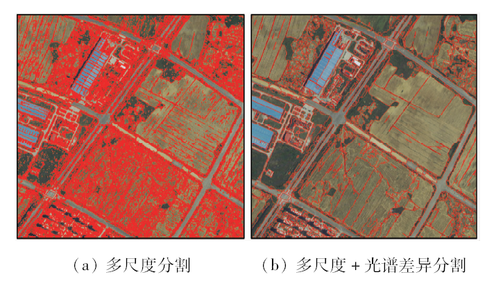
For the purpose of automatically obtaining a large area of winter wheat planting area, phenological information in medium spatial resolution remote sensing images based on time series curves is usually used to identify and extract. However, in actual engineering projects, if phenological information is used only, the accuracy is low. Therefore, a method based on time series curve data classification model and image segmentation is proposed for winter wheat identification. Firstly, the normalized difference vegetation index (NDVI) time series curve of multi-source data is constructed, and the NDVI time series data are smoothed and denoised by harmonic analysis of time series (HANTS) method. Then, via coordinate transformation of NDVI time series, three parameters of band mean, standard deviation and square mean are obtained to construct a new classification model so as to improve the difference between winter wheat and other crops; finally, by combining segmentation results of spatial resolution data, spatial structure information of the image is used to improve accuracy of feature boundary. Taking Jiangning District of Nanjing as an example, the authors used 21 multi-source images of GF-1, Landsat8 and Sentinel-2A from December 2017 to June 2018, and the final extraction accuracy reached 98.74%, which is better than results of other methods. This method provides agricultural management departments with accurate geographic information data on planting area and distribution of winter wheat.
王碧晴, 韩文泉, 许驰. 基于图像分割和NDVI时间序列曲线分类模型的冬小麦种植区域识别与提取[J]. 国土资源遥感, 2020, 32(2): 219-225.
Biqing WANG, Wenquan HAN, Chi XU. Winter wheat planting area identification and extraction based on image segmentation and NDVI time series curve classification model. Remote Sensing for Land & Resources, 2020, 32(2): 219-225.
Zwart S J, Bastiaanssen W G M, Fraiture C D.WATPRO:A remote sensing based model for mapping water productivity of wheat[J]. Agricultural Water Management, 2010,97(10):1628-1636.
Li W G, Jiang N. Extraction of winter wheat planting area by object-oriented classification method[J]. Journal of Triticea Sinica, 2012,32(4):701-705.
[3]
Jiao X F, Kovacs J M, Shang J L, et al. Object-oriented crop mapping and monitoring using multi-temporal polarimetric RADARSAT-2 data[J]. ISPRS Journal of Photogrammetry and Remote Sensing, 2014,96:38-46.
Fan L, Cheng Y Z, Wang L G, et al. Estimation of winter wheat planting area using object-oriented method based on multi-scale segmentation[J]. Journal of China Agricultural Resources and Regional Planning, 2010,31(6):44-51.
Hou G L, Zhang H Y, Wang Y Q, et al. Application of harmonic analysis of time series to extracting the cropland resource in northeast China[J]. Journal of Natural Resources, 2010,25(9):1607-1617.
Deng L Y, Shen Z F, Ke Y M, et al. Winter wheat planting area extraction using multi-temporal remote sensing images based on field parcel[J]. Transactions of the Chinese Society of Agricultural Engineering, 2018,34(21):157-164.
Zhu C M, Luo J C, Shen Z F, et al. Winter wheat planting area extraction using multi-temporal remote sensing data based on field parcel characteristic[J]. Transactions of the Chinese Society of Agricultural Engineering, 2011,27(9):94-99.
Lin Z H, Mo X G. Phenologies from harmonics analysis of AVHRR NDVI time series[J]. Transactions of the Chinese Society of Agricultural Engineering, 2006,22(12):138-144.
Liang S Z, Xing Q G, Shi P, et al. Harmonic analysis on NDVI time series of typical land covers in Shandong Province[J]. Journal of Ecology, 2011,30(1):59-65.
Li J, Liu H B, Li C Y, et al. Changes of green-up day of vegetation growing season based on GIMMS 3g NDVI in northern China in recent 30 years[J]. Geographical Science, 2017,37(4):620-629.
Han Y X, Meng J H. A review of per-field crop classification using remote sensing[J]. Remote Sensing of Land and Resources, 2019,31(2):1-9.doi: 10.6046/gtzyyg.2019.02.01.
Wang B Q, Wang K, Liao W Y. Extraction of Qinghai-Tibet Plateau lake based on remote sensing image segmentation[J]. Remote Sensing Information, 2018,33(1):117-122.
Chen G X, Li P P, Liu S D, et al. Extraction and 3D visualization of surface lithology based on GF-1 satellite images[J]. Geography and Geo-Information Science, 2018,34(5):31-36,2.
Liu C Z, Shu H, Zhang Z, et al. Variogram texture extraction and classification of high resolution remote sensing images based on multi-resolution segmentation[J]. Remote Sensing for Land and Resources, 2015,27(4):47-53.doi: 10.6046/gtzyyg.2015.04.08.
 2020, Vol. 32
  ), 许驰1,3