Remote sensing retrieval of chlorophyll-a and suspended matter in coastal waters of Golden Beach
GAI Yingying(), WANG Zhangjun(), YANG Lei, ZHOU Yan, GONG Jinlong
Institute of Oceanographic Instrumentation, Qilu University of Technology (Shandong Academy of Sciences), Shandong Provincial Key Laboratory of Marine Monitoring Instrument Equipment Technology, National Engineering and Technological Research Center of Marine Monitoring Equipment, Qingdao 266061, China
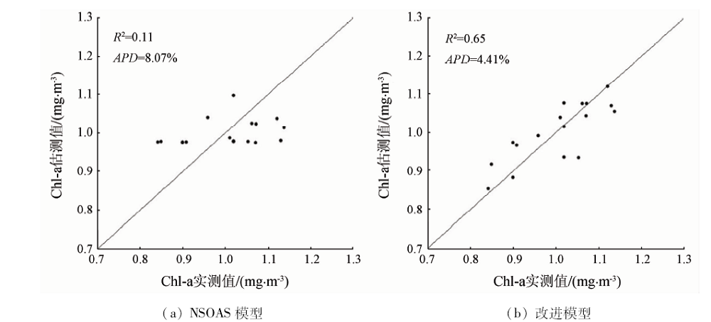
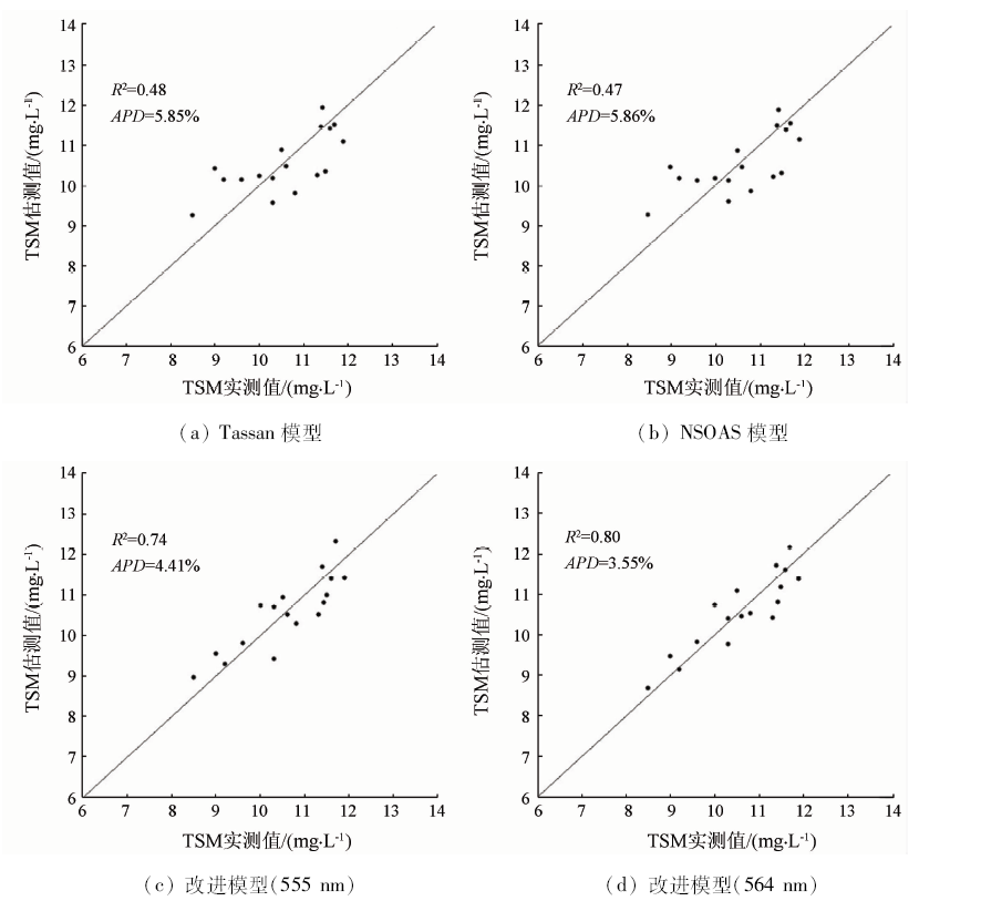
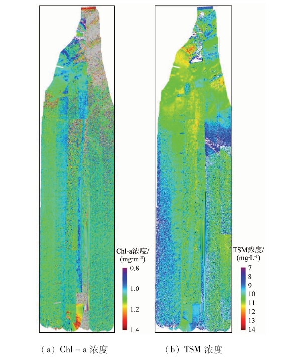
In view of the low precision of existing water quality element retrieval models applied to the coastal waters of Golden Beach, the authors, based on the statistical retrieval models of water color for case Ⅱ water body in Yellow Sea and East China Sea by Tang Junwu, established the retrieval models of chlorophyll-a and total suspended matter concentration for coastal waters of Golden Beach by using the spectral data obtained from airborne marine hyper-spectrometer. The spatial distribution of chlorophyll-a and total suspended matter concentration in the study area was obtained and the influence of hyper-spectrometer gain on model retrieval accuracy was analyzed. After the models were improved, the determination coefficients and average relative errors between the retrieval results from spectrometer measurements and the sampling measurements were respectively chlorophyll-a 0.65, 4.41%, and total suspended matter 0.80, 3.55%. Retrieval results from the same spectrometer at the same coordinates and approximate time but under different gains were compared. It is proved that retrieval average relative errors and root mean square errors of improved models are all increased and the retrieval accuracy is reduced if gain changes. However, the error is in the allowable range and the model stability is good overall.
盖颖颖, 王章军, 杨雷, 周燕, 龚金龙. 金沙滩近岸水体叶绿素a和悬浮物遥感反演研究[J]. 国土资源遥感, 2020, 32(3): 129-135.
GAI Yingying, WANG Zhangjun, YANG Lei, ZHOU Yan, GONG Jinlong. Remote sensing retrieval of chlorophyll-a and suspended matter in coastal waters of Golden Beach. Remote Sensing for Land & Resources, 2020, 32(3): 129-135.
Kim H C, Son S, Kim Y H, et al. Remote sensing and water quality indicators in the Korean west coast:Spatio-temporal structures of MODIS-derived chlorophyll-a and total suspended solids[J]. Marine Pollution Bulletin, 2017,121(1-2):425-434.
pmid: 28641885
Jiang L J. Temporal and spatial variations of suspended sediment and chlorophyll-a in Laizhou Bay in recent 20 years based on remote sensing inversion[D]. Yantai:Ludong University, 2018.
[3]
Jong C P, Mayzonee L, Yong S K, et al. High-spatial resolution monitoring of phycocyanin and chlorophyll-a Using Airborne Hyperspectral imagery[J]. Remote Sensing, 2018,10(8):1-31.
doi: 10.3390/rs10010001
[4]
Purandara B K, Jamadar B S, Chandramohan T, et al. Water quality assessment of a lentic water body using remote sensing:A case study [C]//Singh V P. Environmental Pollution.Singapore:Springer, 2018: 371-380.
Zhang M H, Su H, Ji B W. Retrieving nearshore chlorophyll-a concentration using MODIS time-series images in the Fujian Province[J]. Acta Scientiae Circumstantiae, 2018,38(12):4831-4839.
Sun X H, Hu L B, Feng Y L, et al. Temperal and spatial analysis of chlorophyll a concentration patterns in Rongcheng Bay using HJ-1 satellite data[J].Transactions of Oceanology and Limnology 2018(5):72-79.
[7]
Cao Y, Ye Y T, Zhao H L, et al. Remote sensing of water quality based on HJ-1A HSI imagery with modified discrete binary particle swarm optimization-partial least squares (MDBPSOPLS) in inland waters:A case in Weishan Lake[J]. Ecological Informatics, 2018,44:21-32.
doi: 10.1016/j.ecoinf.2018.01.004
Pan B L, Shen H Y, Shao H, et al. Combined inversion of Hyper-spectral remote sensing of space and spectrum for lake chlorophyll[J]. Journal of Atmospheric and Environmental Optics, 2017,12(6):428-434.
[9]
Mohammad H G, Assefa M M, Lakshmi R. Spaceborne and airborne sensors in water quality assessment[J]. International Journal of Remote Sensing, 2016,37(14):3143-3180.
doi: 10.1080/01431161.2016.1190477
Lin J Y, Zhang C X. Inversion of water quality parameters of urban river network using airborne hyperspectral remote sensing[J]. Remote Sensing Information, 2019,34(2):23-29.
Tang J W, Wang X M, Song Q J, et al. Statistical inversion models for case Ⅱ water color elements in the Yellow Sea and East China Sea[J]. Advances in Marine Science, 2004,22:1-7.
[12]
Tassan S. Local algorithms using SeaWiFS data for the retrieval of phytoplankton,pigments,suspended sediment,and yellow substance in coastal waters[J]. Applied Optics, 1994,33(12):2369-2378.
doi: 10.1364/AO.33.002369
pmid: 20885588
Yang J S, Ge Y Z, Wu Q, et al. Characteristics of ripples both in morphology and sediments in Golden Beach Coastal Zone,Huangdao and the relationship with hydrodynamics[J]. Science and Technology Review, 2014,32(1):22-29.
Bi S, Li Y M, Lyu H, et al. Estimation of chlorophyll-a concentration in Lake Erhai based on OLCI data[J]. Journal of Lake Sciences, 2018,30(3):701-712.
doi: 10.18307/2018.0312
Huang Q H, He Z H, Liang H, et al. Estimation of chlorophyll-a concentration in Baihua Lake water based on hyspectral data[J]. Environmental Science and Technology, 2019,42(1):134-141.
 2020, Vol. 32
  ), 王章军(