A study of the variation and driving factors of the water area of the terminal lake of inland river: A case study of Taitema Lake region
HUO Tianci1(), YAN Wei2(), MA Xiaofei1,3
1. Xinjiang Institute of Ecology and Geography, Chinese Academy of Sciences, Urumqi 830011, China 2. School of Geographic Sciences, Xinyang Normal University, Xinyang 464000, China 3. University of Chinese Academy of Sciences, Beijing 100049, China
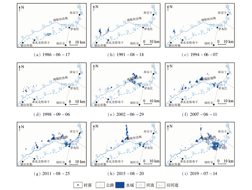
Terminal lake, which is an important part of oasis ecosystem in the lower reaches of inland river in arid region, has the functions of water conservation, wind prevention and sand fixation. However, for nearly half a century, the terminal lake of inland river has been shrinking under the influence of climate change and human activities, and the ecological environment around the lake has been deteriorating, which has seriously threatened the regional social development. In order to explore the changes and driving factors of the water area of the terminal lake in the arid region, this paper took the Taitema Lake region as an example, selected nine Landsat TM/OLI remote sensing images from 1986 to 2019, and extracted and analyzed the change characteristics and driving factors of the water area of the Taitema Lake region. The results showed that the water area of the study region increased by 163.93 km 2 in the past 34 years. In terms of spatial distribution, water area of the study region was scattered around the lower reaches of Qarqan River before the 21st century, and mainly distributed around Taitema Lake since the 21st century. The center of gravity of the water area in the study region experienced four processes: rapid westward shift in the late 1980s, slow eastward shift in the 1990s, rapid eastward shift in the late 1990s to early 2000s, and eastward shift in the fluctuation since the 21st century. Taking the water transport to the lower reaches of Tarim River as the boundary, the water area before water transport is mainly affected by the comprehensive effects of regional natural factors, with precipitation as the main driving factor (r2=0.825). After water transport, the water transport process with human intervention is the leading factor (r2=0.977) affecting the change of water area in the study region. With the continuous water transfer to the downstream of Tarim River, the ecological environment of Taitema Lake has been restored continuously. In order to prevent the lake from overflowing and spilling eastward into Lop Nor, it is necessary to explore the maximum water capacity of Taitema Lake so as to reasonably control the water transfer.
霍天赐, 颜伟, 马晓飞. 内陆河尾闾湖泊水域面积变化及驱动因素研究——以台特玛湖地区为例[J]. 国土资源遥感, 2020, 32(3): 149-156.
HUO Tianci, YAN Wei, MA Xiaofei. A study of the variation and driving factors of the water area of the terminal lake of inland river: A case study of Taitema Lake region. Remote Sensing for Land & Resources, 2020, 32(3): 149-156.
Chen X, Bao A M, Wang X P, et al. Ecological effect evaluation of comprehensive control project in Tarim River basin[J]. Bulletin of Chinese Academy of Sciences, 2017,32(1):20-28.
Yang P N, Deng M J, Li X, et al. Respond width of groundwater level after conveying stream water to the lower reaches of the Tarim River,Xinjiang:A case study along the Yengisu section in the lower reaches of Tarim River[J].Arid Zone Research 2008(3):331-335.
Xu H L, Fan Z L, Yang P N, et al. Short term evaluation and advice of compiling planning for the Tarim River basin in future[J]. Arid Land Geography, 2015,38(4):645-651.
Yang Y, Guo Y P. The change and prospect of vegetation in the end of the lower reaches of Tarim River after ecological water delivering[J].Journal of Desert Research 2004(2):55-60.
Li L J, Zhang X Q, Chen C Q, et al. Ecological effects of water conveyance on the lower reaches of Tarim River in recent twenty years[J]. Arid Land Geography, 2018,41(2):238-247.
Wang Y M, Zhang Q Q, Xu H L, et al. Change of plant diversity in the Taitema Lake area before and after implementing the ecological water conveyance[J]. Arid Zone Research, 2019,36(5):1186-1193.
[7]
钟家骅. 塔里木河流域植被生态变化研究[D]. 西安:长安大学, 2018.
Zhong J H. The changes of the vegetation ecosystems in Tarim River Basin[D]. Xi’an:Chang’an University, 2018.
[8]
郭继凯. 塔里木河流域植被覆盖对气候变化和人类活动的响应[D]. 北京:北京林业大学, 2016.
Guo J K. Responses of vegetation coverage to climate change and human activities in the Tarim River basin[D]. Beijing:Beijing Forestry University, 2016.
Huang Y, Bao A M, Wang S F, et al. Eco-environmental change in the lower Tarim River under the influence of intermittent water transport[J]. Acta Geographica Sinica, 2013,68(9):1251-1262.
doi: 10.11821/dlxb201309008
Ablekim A, Kasimu A, Kurban A, et al. Monitoring the water area changes in Tetima-Kanglayka lakes region over the past four decades by remotely sensed data[J]. Journal of Lake Sciences, 2014,26(1):46-54.
doi: 10.18307/2014.0106
Wang S Y. Study on the evolution and driving factors of ecological environment in the Taitema Lake area in recent 30 years[D]. Shijiazhuang:Hebei Normal University, 2019.
[13]
McFeeters S K. The use of the normalized difference water index (NDWI) in the delineation of open water features. International Journal of Remote Sensing, 1996,17(7):1425-1432.
Xu H Q. A study on information extraction of water body with the modified normalized difference water index (MNDWI)[J].Journal of Remote Sensing 2005(5):589-595.
Wu C Y, Chen K L, Cao G C, et al. The spatial and temporal differences and driving forces of wind erosion climatic erosivity in Qinghai Province from 1984 to 2013[J]. Geographical Research, 2018,37(4):717-730.
Ziyinali H, Wu Z P, Baolangtijiang K. Lake changes in spatial evolution and driving force for the water area change of the Manas lake in Xinjiang in the past forty years[J]. Remote Sensing for Land and Resources, 2018,30(1):217-223.doi: 10.6046/gtzyyg.2018.01.30.
Huang P T, Zhang X P. Analysis of temporal and spatial movement of the gravity center of city industry:A case study of Tianjin[J]. Economic Geography, 2012,32(3):89-95.
Deng M J, Yang P N, Zhou H Y, et al. Water conversion and strategy of ecological water conveyance in the lower reaches of the Tarim River[J]. Arid Zone Research, 2017,34(4):717-726.
Zhu C M, Li J L, Shen Z F, et al. Time series monitoring and comparative analysis on eco-environment change in the lower reaches of the Tarim River[J]. Journal of Geo-Information Science, 2019,21(3):437-444.
Ran J J, Ji M X, Huang J P, et al. Characteristics and factors of climate change in arid and semi-arid areas over northern China in the recent 60 years[J]. Journal of Lanzhou University(Natural Sciences), 2014,50(1):46-53.
Li L, Zeng Q W, Zhou H Z, et al. Change and causes of the river-lake marshes along the green corridor at the lower reaches of the Qarqan River[J]. Arid Zone Research, 2012,29(2):233-237.
 2020, Vol. 32
  ), 颜伟2(