Extraction and analysis of soil salinization information of Alar reclamation area based on spectral index modeling
DAI Yunhao1(), GUAN Yao1, FENG Chunyong2, JIANG Min1, HE Xinghong1()
1. College of Water Conservancy and Architecture Engineering, Tarim University, Alar 843300, China 2. Department of Geographical Sciences, Beijing Normal University, Beijing 100088, China
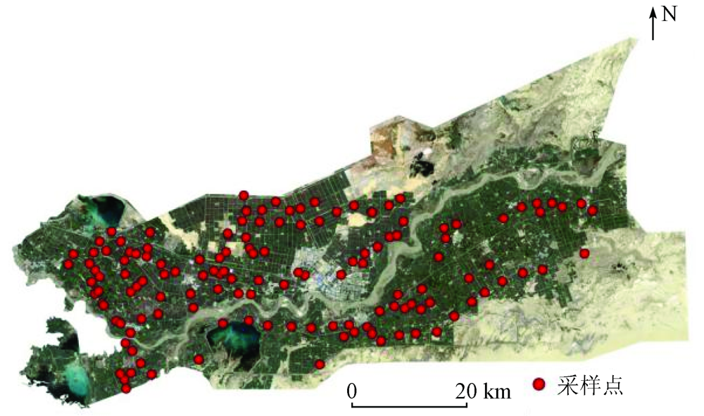
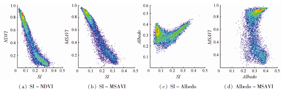
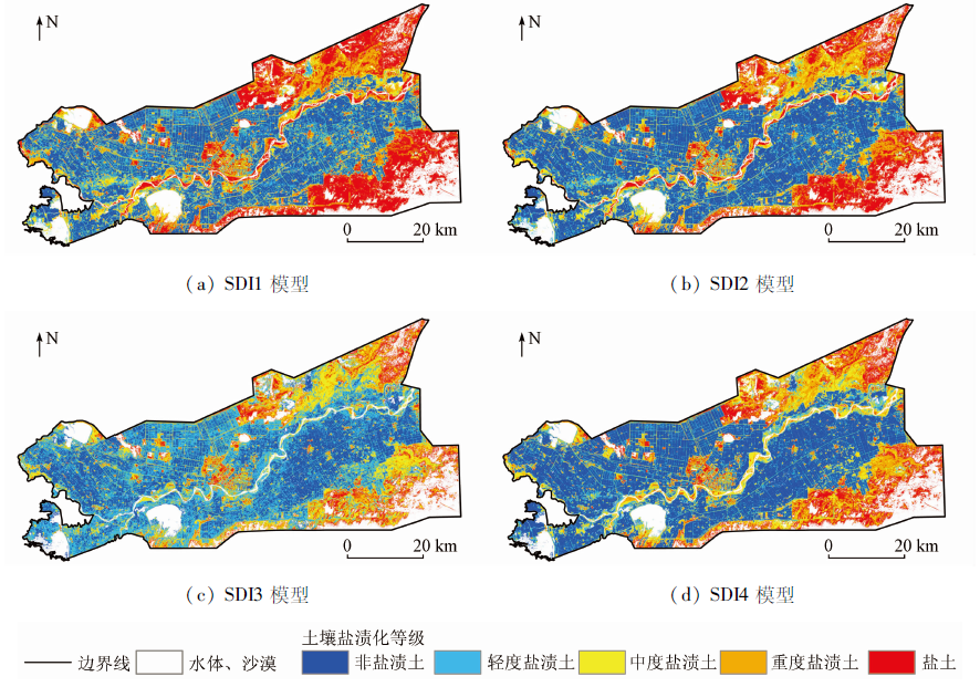
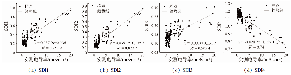
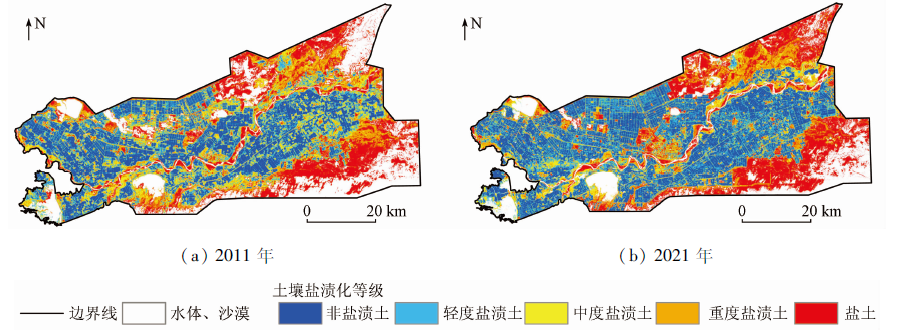
This study aims to explore the optimal remote sensing salinization detection index (SDI) model for the inversion of soil salinization in the Alar reclamation area. Based on Landsat8 OLI remote sensing images and field measured data, this study built the remote sensing SDI models using the salinity index (SI), the normalized difference vegetation index (NDVI), the modified soil adjusted vegetation index (MSAVI), and the surface albedo. Then, using these models, this study extracted the soil salinization information on the Alar reclamation area and verified the model precision. Finally, this study determined the optimal remote sensing-based SDI model through comparative analysis. The results are as follows. The four types of remote sensing-based SDI models SDI1 (SI-NDVI), SDI2 (SI-MSAVI), SDI3 (SI-Albedo), and SDI4 (Albedo-MSAVI)had general classification precision of 83.45%, 69.78%, 53.23%, and 71.94%, respectively. Model SDI1 was the most suitable for the inversion of the degree of soil salinization in the Alar reclamation area. Models SDI2 and SDI4 can be utilized as a reference for soil salinization monitoring of the Alar reclamation area. As revealed by the inversion results of the SDI model, the reclamation area is dominated by non-saline and lightly saline soils, with heavily saline soil and saline soil primarily distributed in the northeast and southeast. Model SDI1 established based on SI and NDVI has high accuracy in extracting the soil salinization information of the Alar reclamation area and can be used as the remote sensing-based SDI model for the inversion of soil salinization in reclamation areas. This study can provide an effective technical reference for the control and prevention of soil salinization.
代云豪, 管瑶, 冯春涌, 蒋敏, 贺兴宏. 基于光谱指数建模的阿拉尔垦区土壤盐渍化信息提取与分析[J]. 自然资源遥感, 2023, 35(1): 205-212.
DAI Yunhao, GUAN Yao, FENG Chunyong, JIANG Min, HE Xinghong. Extraction and analysis of soil salinization information of Alar reclamation area based on spectral index modeling. Remote Sensing for Natural Resources, 2023, 35(1): 205-212.
Shatiwu M, Tashenpulati N, Ding J L, et al. Remote sensing monitoring and evaluation of soil salinization in arid areas[M]. Beijing: Beijing University of Technology Press, 2018.
Jia P P, Shang T H, Zhang J H, et al. Inversion of soil salinity in dry and wet seasons based on multi-source spectral data inYinbei area of Ningxia,China[J]. Transactions of the Chinese Society of Agricultural Engineering, 2020, 36(17):125-134.
Tumaerbai H, Zhao Y C, Aihemaiti M, et al. Study on characteristics of cotton field soil salt accumulation under perennialmulched drip irrigation in Northern Xinjiang[J]. Journal of Irrigation and Drainage, 2016, 35(1):1-5.
Wu Y K, Liu G M, Shu L T, et al. Accurate evaluation of regional soil salinization using multi-source data[J]. Spectroscopy and Spectral Analysis, 2018, 38(11):3528-3533.
[6]
Alqasemi A S, Ibrahim M, Al-Quraishi A M F, et al. Detection and modeling of soil salinity variations in arid lands using remote sensing data[J]. Open Geosciences, 2021, 13(1):443-453.
doi: 10.1515/geo-2020-0244
[7]
Sidike A, Zhao S, Wen Y. Estimating soil salinity in Pingluo County of China using QuickBird data and soil reflectance spectra[J]. International Journal of Applied Earth Observation and Geoinformation, 2014, 26:156-175.
doi: 10.1016/j.jag.2013.06.002
[8]
Wang F, Chen X, Luo G P, et al. Detecting soil salinity with arid fraction integrated index and salinity index in feature space using Landsat TM imagery[J]. Journal of Arid Land, 2013, 5(3):340-353.
doi: 10.1007/s40333-013-0183-x
Chen H Y, Zhao G X, Chen J C, et al. Remote sensing inversion of saline soil salinity based on modified vegetation index in estuary area of Yellow River[J]. Transactions of the Chinese Society of Agricultural Engineering, 2015, 31(5):107-112,113,114.
Chen S, Gao G, Xu B, et al. Quantitative inversion of soil salinity and analysis of its spatial pattern in agricultural area in Shihezi of Xinjiang[J]. Geographical Research, 2014, 33(11):2135-2144.
doi: 10.11821/dlyj201411013
Ding J L, Yao Y, Wang F. Detecting soil salinization in arid regions using spectral feature space derived from remote sensing data[J]. Acta Ecologica Sinica, 2014, 34(16):4620-4631.
Shi X Y, Li W D, Yu L, et al. Remote sensing quantitative evaluation of soil salinization in agricultural irrigation areas of Manas River Basin[J]. Journal of Irrigation and Drainage, 2018, 37(11):69-75,83.
Ding B X, Bai Y G, Chai Z P, et al. Soil salinization characteristics and its seasonal variation in oasis irrigation district of lower reaches of Tarim River[J]. Bulletin of Soil and Water Conservation, 2020, 40(2):77-84,2.
Yang X H, Luo Y Q, Yang H C, et al. Soil salinity retrieval and spatial distribution of oasis farmland in Manasi river basin[J]. Journal of Arid Land Resources and Environment, 2021, 35(2):156-161.
Bai J D, Peng J, Bai Z J, et al. Clarifying spatial-temporal variability of surface soil salinization in arid cotton fields[J]. Chinese Journal of Soil Science, 2021, 52(3):527-534.
Chen S, Xu B, Jin Y X, et al. Remote sensing monitoring and spatial-temporal characteristics analysis of soil salinization in agricultural area of Northern Xinjiang[J]. Science Geographic Science, 2015, 35(12):1607-1615.
Wang F, Ding J L, Wu M C. Remote sensing monitoring models of soil salinization based in NDVI-SI feature space[J]. Transactions of the Chinese Society of Agricultural Engineering, 2010, 26(8):168-173,8.
Zhang T Y, Wang L, Zeng P L, et al. Soil salinization in the irrigated area of the Manas River Basin based on MSAVI-SI feature space[J]. Arid Zone Research, 2016, 33(3):499-505.
Feng J, Ding J L, Wei W Y. Remote sensing modeling of soil salinization information in arid areas[J]. Agricultural Research in the Arid Areas, 2018(2):147-152.
Song Q, Feng C H, Gao Q, et al. Change of cultivated land and its driving factors in Alar Reclamation Area in the past thirty years[J]. Remote Sensing for Land and Resources, 2021, 33(2):202-212.doi:10.6046/gtzyyg.2020183.
doi: 10.6046/gtzyyg.2020183
[22]
新疆生产建设兵团年鉴编辑委员会. 兵团年鉴[M]. 新疆: 新疆生产建设兵团年鉴社, 2020.
Editorial Committee of Xinjiang Production and Construction Corps Yearbook. Corps yearbook[M]. Xinjiang: Xinjiang Production and Construction Corps Yearbook Society, 2020.
Mo Z X, Liu W Y, Wu W M. Research on the genetic characteristic and taxonomy of soils in Aral irrigated area[J]. Agricultural Research in the Arid Areas, 2009, 27(6):40-43,57.
Lu J, Zhang X J, Ye P S, et al. Remote sensing monitoring of salinization in Hetao irrigation district based on SI-MSAVI feature space[J]. Remote Sensing for Land and Resources, 2020, 32(1):169-175.doi:10.6046/gtzyyg.2020.01.23.
doi: 10.6046/gtzyyg.2020.01.23
Wu X, Wang C J, Fan L Q, et al. An applicability analysis of salinization evaluation index based on multispectral remote sensing to soil salinity prediction in Yinbei irrigation area of Ningxia[J]. Remote Sensing for Land and Resources, 2021, 33(2):124-133.doi:10.6046/gtzyyg.2020210.
doi: 10.6046/gtzyyg.2020210
[26]
Wivedi R S, Rao B R M. The selection of the best possible Landsat TM band combination for delineating salt-affected soils[J]. International Journal of Remote Sensing, 1992, 13(11):2051-2058.
doi: 10.1080/01431169208904252
Wu J L. Remote sensing monitoring and cotton plantation benefit analysis of cotton field soil salinization in Alar Reclamation Area[D]. Aral: Tarim University, 2021.
Bian L L, Wang J L, Guo B, et al. Remote sensing extraction of soil salinity in Yellow River delta Kenli County based on feature space[J]. Remote Sensing Technology and Application, 2020, 35(1):211-218.
[29]
王遵亲, 祝寿泉, 尤文瑞, 等. 中国盐渍土[M]. 北京: 科学出版社,1993.
Wang Z Q, Zhu S Q, You W R, et al. Saline soil in China[M]. Beijing: Science Press,1993.
[30]
Staff U S S L. Diagnosis and improvement of saline and alkali soils[J]. Agriculture Handbook, 1954, 60:83-100.
Li Y J, Ding J L, Ainiwaer M. Soil salt distribution and the factors affect it in Ogan Kucha River Oasis[J]. Journal of Irrigation and Drainage, 2019, 38(6):58-65.
 2023, Vol. 35
  ), 管瑶1, 冯春涌2, 蒋敏1, 贺兴宏1(