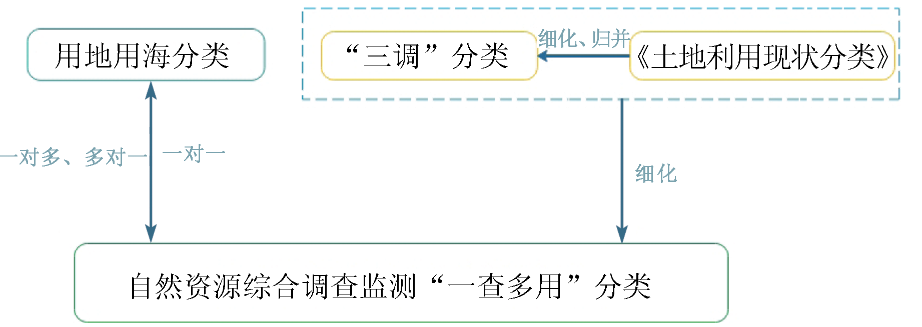
Based on the technical research task of “one survey for multiple purposes” in the national pilot project of integrated survey and monitoring of natural resources, this study aims to connect multiple special surveys of natural resources and multisectoral purposes through one integrated survey. First, this study analyzed the existing land classification and the Guidelines for the Classification of Land and Sea Use for Land and Space Survey, Planning, and Use Control (trial). Then, it formulated the criteria for the classification of “one survey for multiple purposes” for the integrated survey and monitoring of natural resources by subdividing some land categories according to the Land Use Classification. Moreover, the verification results show that the criteria for the classification enable the mutual conversion of classifications, such as land and sea use classification and land survey classification, and can connect to special surveys by rapidly providing special resource survey layers.
蒋毅, 马克委, 王云凯, 杨红军, 何燕兰. 自然资源综合调查监测“一查多用”分类体系研究[J]. 自然资源遥感, 2023, 35(2): 264-270.
JIANG Yi, MA Kewei, WANG Yunkai, YANG Hongjun, HE Yanlan. The “one survey for multiple purposes” classification system for integrated survey and monitoring of natural resources. Remote Sensing for Natural Resources, 2023, 35(2): 264-270.
Gu L Y. Thoughts on innovation and improvement of national natural resources supervision system[J]. Natural Resource Economics of China, 2020, 33(6):10-17.
China Land resources Economy Research Editorial Group. Scientific classification of natural resources to promote unified management system governance[N]. China Natural Resources News,2018-6-21(5).
Gong J, Li J Y, Wei Z R, et al. Land use classification system and governance for unified management of natural resources[J]. Planners, 2020, 36(10):42-49.
Qiao C F, Zhao Y, Liu Y. From comparison between national geographic condition census data and resources and environment investigation data to development of national geographic condition monitoring[J]. Geomatics & Spatial Information Technology, 2019, 42(1):7-9.
Chen H P, Zhang L, Guo J, et. Studies on method of quality inspection for land cover achievement[J]. Geomatics and Spatial Information Technology, 2018, 41(7):72-74.
Ye Y Z, Zhang C M, Deng Y, et al. Research on the current situation and problems of natural resources monitoring and natural resources assets monitoring in China[J]. Bulletin of Surveying and Mapping, 2019(10):23-29.
doi: 10.13474/j.cnki.11-2246.2019.0312
Li D R, Zhang L P, Xia G S. Automatic analysis and mining of remote sensing big data[J]. Acta Geodaetica et Cartographica Sinica, 2014, 43(12):1211-1216.
doi: 10.13485/j.cnki.11-2089.2014.0187
Huang J J, Tang C Z, Li Y, et al. System construction for survey and monitoring of natural resources in Guangxi[J]. Remote Sensing for Land and Resources, 2020, 32(2):154-161.doi:10.6046/gtzyyg.2020.02.20.
doi: 10.6046/gtzyyg.2020.02.20
Cheng Y, Zhao M. On the land-use classification system in the context of territorial spatial planning:Classification structure and application rationale[J]. Urban Planning Forum, 2021(4):51-57.
 2023, Vol. 35
  ), 马克委, 王云凯, 杨红军, 何燕兰