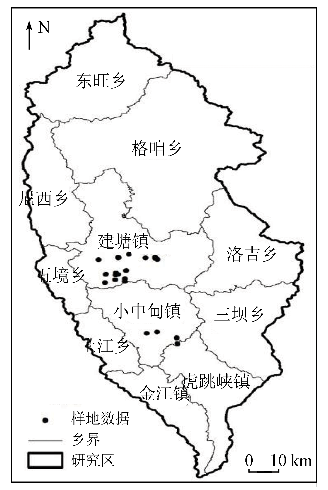
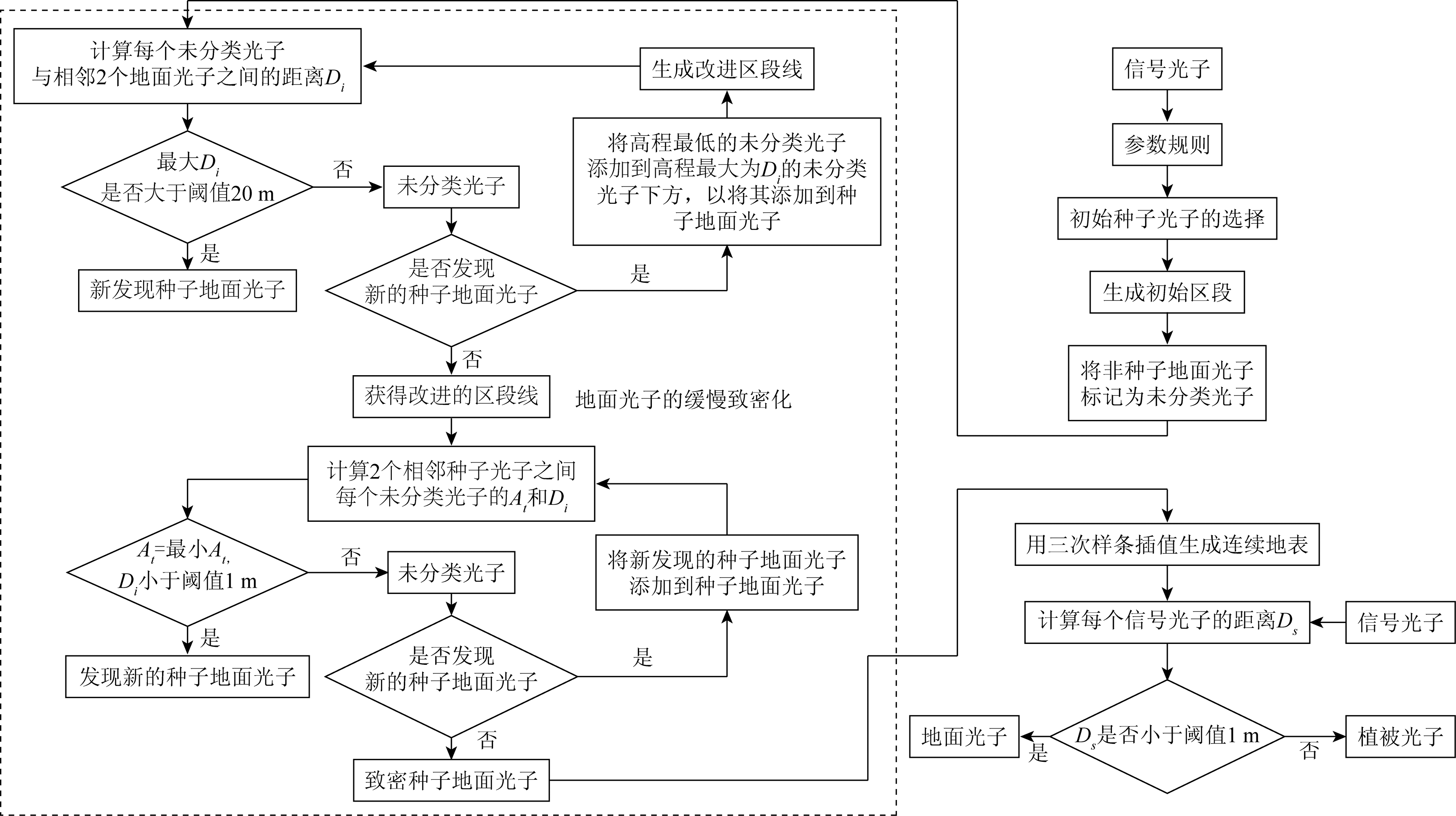
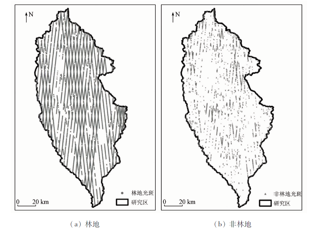
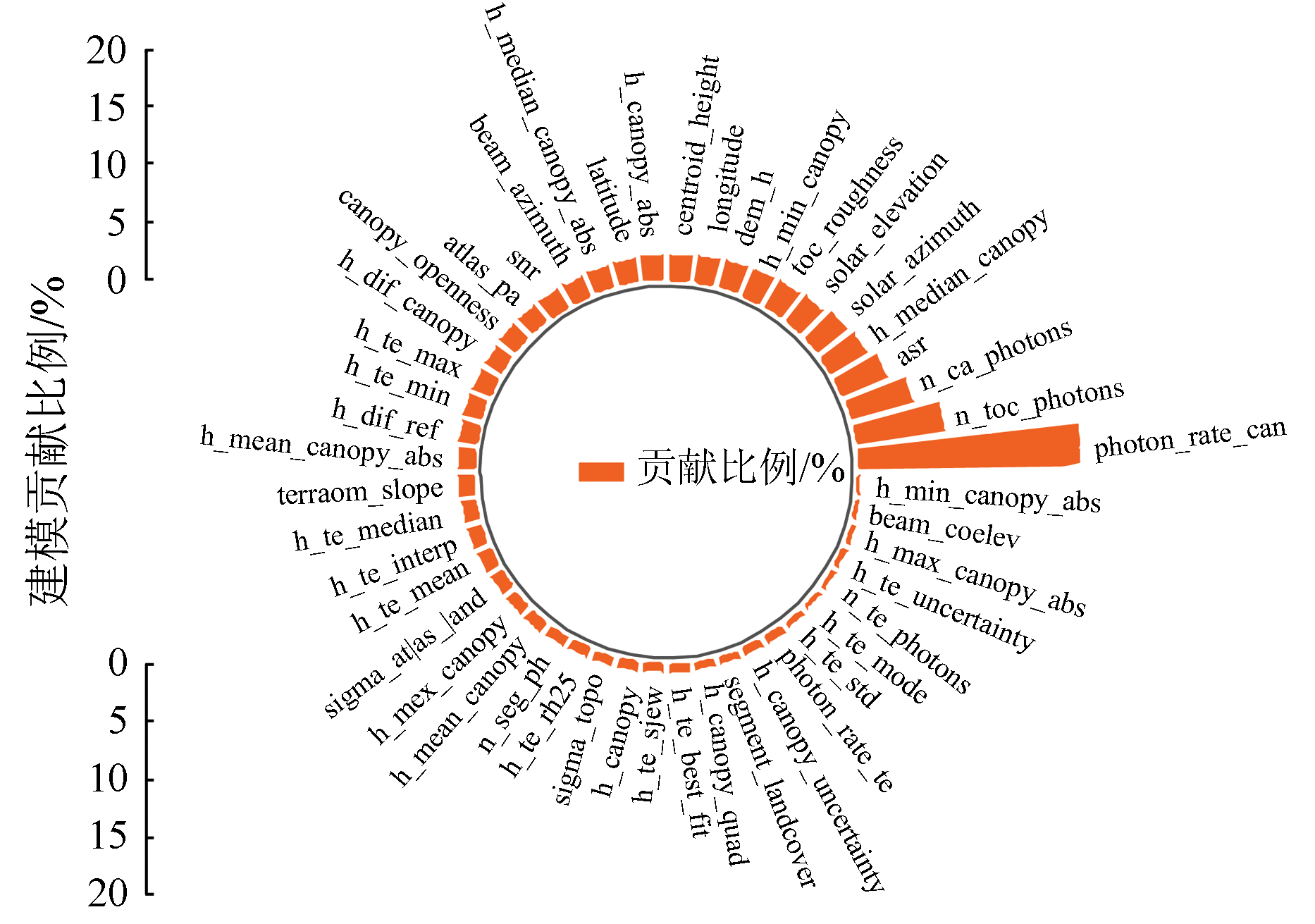
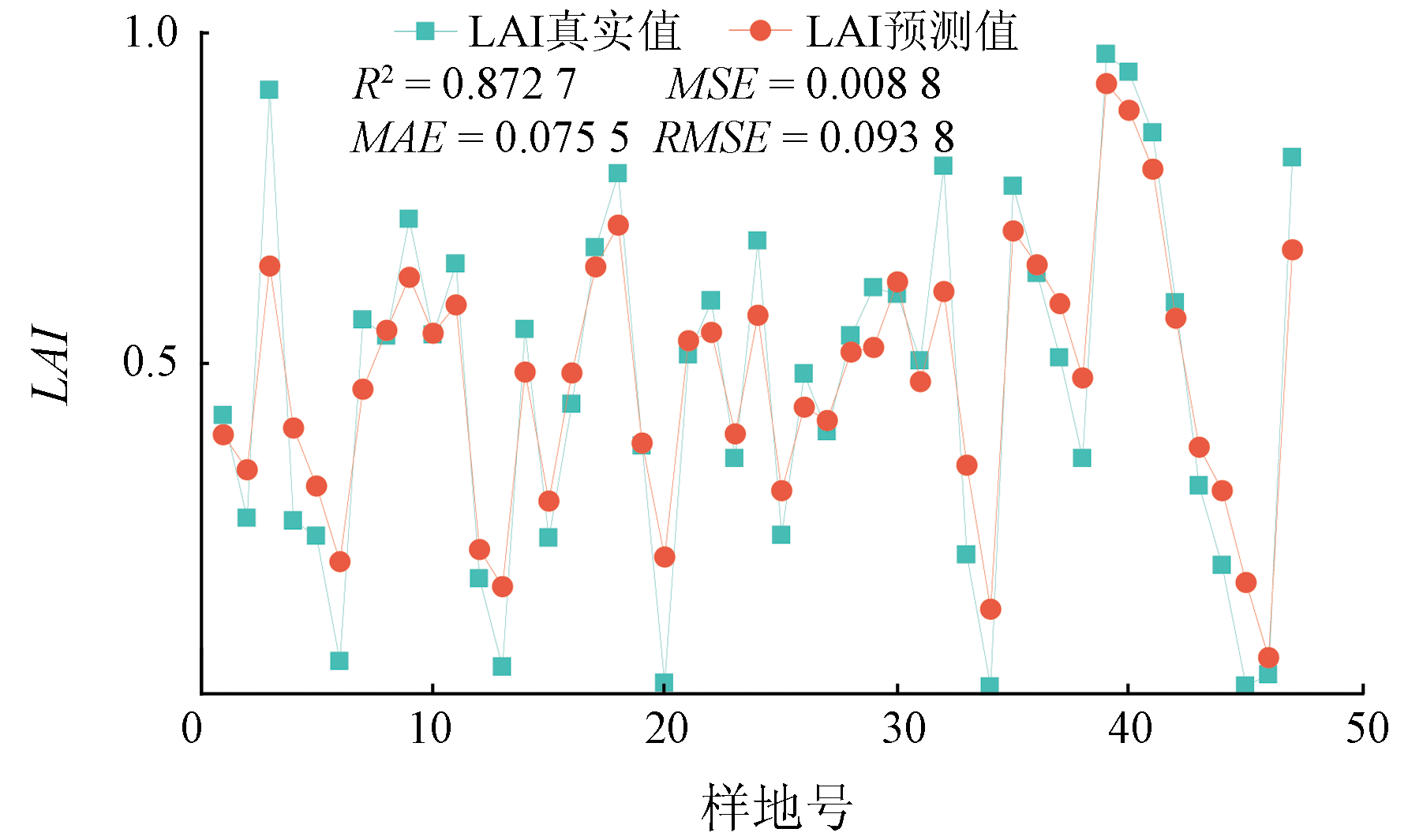
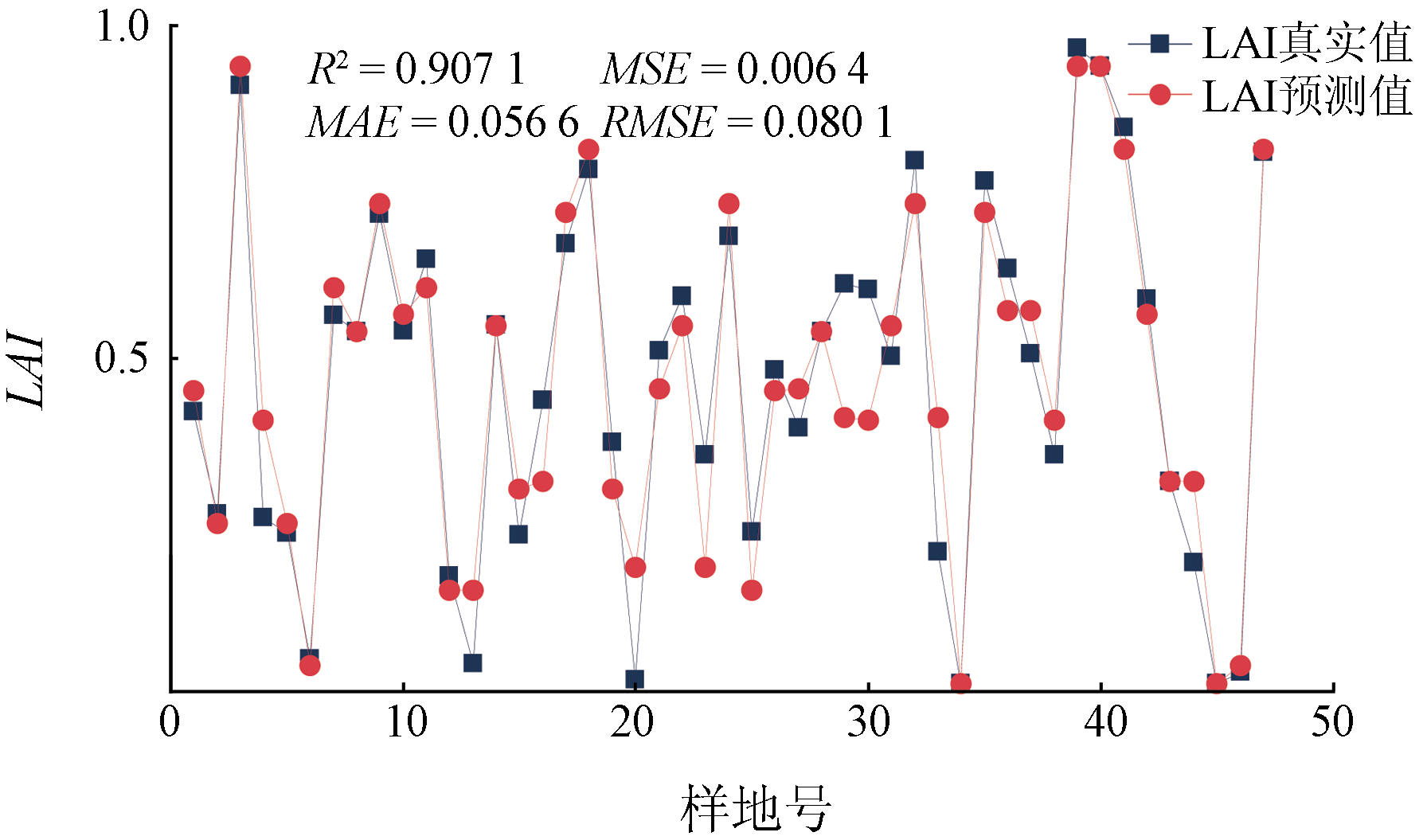
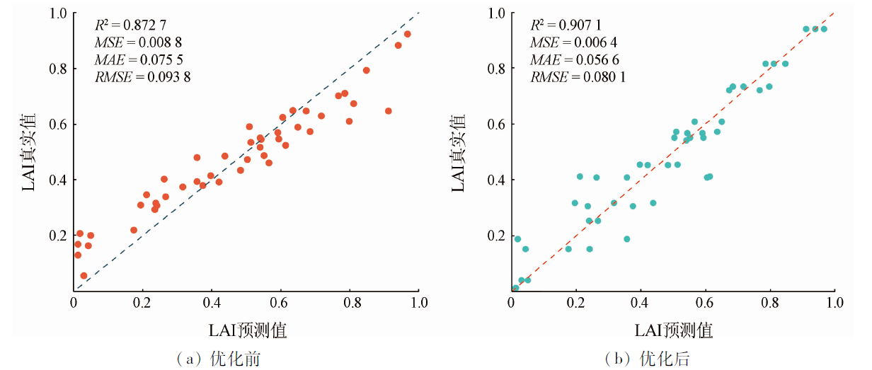
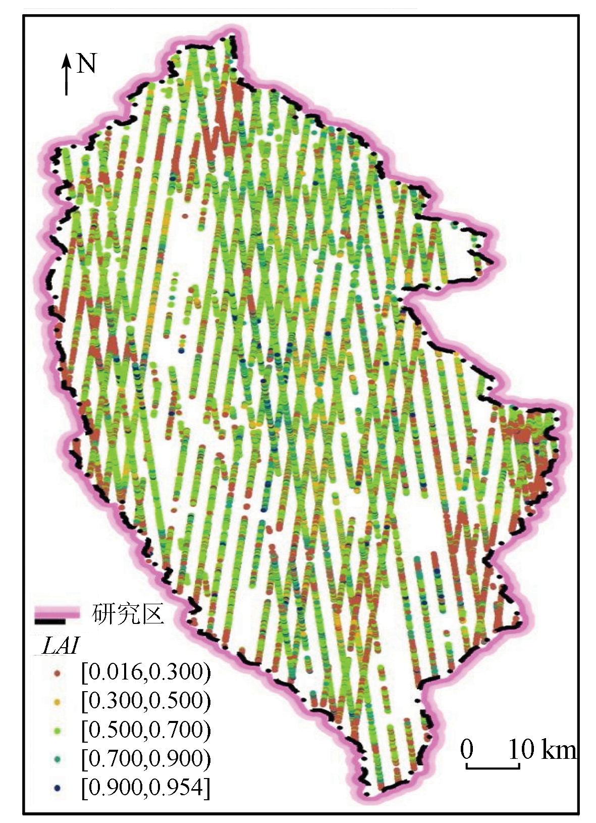
叶面积指数(leaf area index,LAI)是森林生态系统重要参数,如何以较小成本提升区域尺度的山地森林LAI的遥感估测精度,对于精确掌握森林LAI的情况和进一步了解森林生态系统有重要意义。本研究以星载激光雷达ICESAT-2/ATLAS为主要信息源,以西南山地香格里拉市为研究区,基于随机森林回归(random forest,RF)遥感估测模型,结合地面51块LAI实测样地数据,在前期进行RF超参数优化基础上,采用决定系数、均方根误差、绝对平均误差和中位数绝对误差作为模型精度评价指标,对估测效果进行分析。结果表明: 使用随机表面查找算法进行RF回归模型的超参数优化,能明显提升模型估测LAI精度。提取出的地面光斑特征参数在山地森林LAI估测中有较高的贡献度和极佳的效果,可用于区域尺度的山地森林物理结构参数LAI的估测。同时,利用随机表面查找算法优化后的RF回归模型,估测精度更高,估测结果与研究区森林分布现状吻合,具有一定普适性。最后,研究确定了使用ICESat-2/ATLAS数据产品估测LAI是可行的,能为星载激光雷达估测中大范围的LAI提供一定的参考。
The leaf area index (LAI) is a critical parameter for the forest ecosystem. Improving the remote sensing estimation accuracy of the regional LAI of mountain forests at a low cost is of great significance for accurately determining the LAIs of forests and for further understanding the forest ecosystem. With spaceborne LiDAR ICESat-2/ATLAS data as a primary information source, this study investigated Shangri-La City in mountainous areas in southwestern China. Based on the remote sensing estimation model using random forest (RF) regression, RF hyperparameter optimization, and the data of 51 measured sample plots of LAI, this study analyzed the estimation effects of the model using accuracy evaluation indicators such as coefficient of determination (R2), root mean square error (RMSE), mean absolute error (MAE), and median absolute error (MedAE). The results are as follows: The hyperparameter optimization of the RF regression model using a random surface search algorithm can significantly improve the estimation accuracy of LAI. The extracted characteristic parameters of ground spots showed high contribution and excellent effects in the LAI estimation of mountain forests. Therefore, they can be applied to the estimation of regional LAI of mountain forests. The RF regression model optimized using the random surface search algorithm yielded higher estimation accuracy. The estimation results were consistent with the forest distribution in the study area, indicating certain generality. Finally, this study determined that it is feasible to employ ICESat-2/ATLAS data products for LAI estimation, providing a reference for medium- to large-scale LAI estimation based on spaceborne LiDAR.
席磊, 舒清态, 孙杨, 黄金君, 宋涵玥. 基于ICESat2的西南山地森林LAI遥感估测模型优化[J]. 自然资源遥感, 2023, 35(3): 160-169.
XI Lei, SHU Qingtai, SUN Yang, HUANG Jinjun, SONG Hanyue. Optimizing an ICESat2-based remote sensing estimation model for the leaf area index of mountain forests in southwestern China. Remote Sensing for Natural Resources, 2023, 35(3): 160-169.
Chen J M, Menges C H, Leblanc S G. Global mapping of foliage clumping index using multi-angular satellite data[J]. Remote Sensing of Environment, 2005, 97(4):447-457.
doi: 10.1016/j.rse.2005.05.003
[2]
Friedl M A, Sulla-Menashe D, Tan B, et al. MODIS collection 5 global land cover:Algorithm refinements and characterization of new datasets[J]. Remote Sensing of Environment, 2010, 114(1):168-182.
doi: 10.1016/j.rse.2009.08.016
Lin X J. Remote sensing diagnosis of forest canopy height and forest aboveground biomass based on ICESat-2 and GEDI[D]. Beijing: University of Chinese Academy of Sciences (Aerospace Information Research Institute,Chinese Academy of Sciences), 2021.
[4]
Moussavi M S, Abdalati W, Scambos T, et al. Applicability of an automatic surface detection approach to micro-pulse photon-counting LiDAR altimetry data:Implications for canopy height retrieval from future ICESat-2 data[J]. International Journal of Remote Sensing, 2014, 35(13):5263-5279.
doi: 10.1080/01431161.2014.939780
[5]
Liu M S, Xing Y Q, Wu H B, et al. Study on mean forest canopy height estimation based on ICESat-GLAS waveforms[J]. Forest Research, 2014, 27(3):309-315.
[6]
García M, Popescu S, Riaño D, et al. Characterization of canopy fuels using ICESat/GLAS data[J]. Remote Sensing of Environment, 2012, 123:81-89.
doi: 10.1016/j.rse.2012.03.018
[7]
Luo S, Wang C, Li G, et al. Retrieving leaf area index using ICESat/GLAS full-waveform data[J]. Remote Sensing Letters, 2013, 4(8):745-753.
doi: 10.1080/2150704X.2013.790573
[8]
Neumann T A, Martino A J, Markus T, et al. The ice,cloud,and land elevation satellite-2 mission:A global geolocated photon product derived from the advanced topographic laser altimeter system[J]. Remote Sensing of Environment, 2019, 233:111325.
doi: 10.1016/j.rse.2019.111325
[9]
Huang X, Xie H, Liang T, et al. Estimating vertical error of SRTM and map-based DEMs using ICESat altimetry data in the eastern Tibetan Plateau[J]. International Journal of Remote Sensing, 2011, 32(18):5177-5196.
doi: 10.1080/01431161.2010.495092
Dong J C, Ni W J, Zhang Z Y, et al. Performance of ICESat-2 ATL08 product on the estimation of forest height by referencing to small footprint LiDAR data[J]. National Remote Sensing Bulletin, 2021, 25(6):1294-1307.
doi: 10.11834/jrs.20219449
[11]
Huang J P, Xing Y Q, Qin L. Review of noise filtering algorithm for photon data[J]. The International Archives of Photogrammetry,Remote Sensing and Spatial Information Sciences, 2020, 42:105-110.
[12]
Gwenzi D, Lefsky M A, Suchdeo V P, et al. Prospects of the ICESat-2 laser altimetry mission for savanna ecosystem structural studies based on airborne simulation data[J]. ISPRS Journal of Photogrammetry and Remote Sensing, 2016, 118:68-82.
doi: 10.1016/j.isprsjprs.2016.04.009
Zhang H, Li H Y, Li H J, et al. Accuracy evaluation of remote sensing elevation data in alpine mountains based on airborne LiDAR[J]. Remote Sensing Technology and Application, 2021, 36(6):1311-1320.
[14]
Neuenschwander A L, Magruder L A. The potential impact of vertical sampling uncertainty on ICESat-2/ATLAS terrain and canopy height retrievals for multiple ecosystems[J]. Remote Sensing, 2016, 8(12):1039.
doi: 10.3390/rs8121039
[15]
Narine L L, Popescu S, Neuenschwander A, et al. Estimating aboveground biomass and forest canopy cover with simulated ICESat-2 data[J]. Remote Sensing of Environment, 2019, 224:1-11.
doi: 10.1016/j.rse.2019.01.037
[16]
Zhang J, Tian J, Li X, et al. Leaf area index retrieval with ICESat-2 photon counting LiDAR[J]. International Journal of Applied Earth Observation and Geoinformation, 2021, 103:102488.
doi: 10.1016/j.jag.2021.102488
[17]
Shi L, Zhao H, Li Y, et al. Evaluation of Shangri-La County’s tourism resources and ecotourism carrying capacity[J]. International Journal of Sustainable Development and World Ecology, 2015, 22(2):103-109.
doi: 10.1080/13504509.2014.927018
E X Y, Dai G Y, Wu S H. ICESat-2 ATL03 data preprocessing and correction method[J]. Infrared and Laser Engineering, 2021, 50(6):92-102.
[19]
Magruder L, Neumann T, Kurtz N. ICESat-2 early mission synopsis and observatory performance[J]. Earth and Space Science, 2021, 8(5): e2020EA001555.
[20]
Neuenschwander A, Guenther E, White J C, et al. Validation of ICESat-2 terrain and canopy heights in boreal forests[J]. Remote Sensing of Environment, 2020, 251:112110.
doi: 10.1016/j.rse.2020.112110
[21]
Parrish C E, Magruder L A, Neuenschwander A L, et al. Validation of ICESat-2 ATLAS bathymetry and analysis of ATLAS’s bathymetric mapping performance[J]. Remote Sensing, 2019, 11(14):1634.
doi: 10.3390/rs11141634
[22]
Wang C, Zhu X, Nie S, et al. Ground elevation accuracy verification of ICESat-2 data:A case study in Alaska,USA[J]. Optics Express, 2019, 27(26):38168-38179.
doi: 10.1364/OE.27.038168
[23]
Ghosh S M, Behera M D, Paramanik S. Canopy height estimation using Sentinel series images through machine learning models in a mangrove forest[J]. Remote Sensing, 2020, 12(9):1519.
doi: 10.3390/rs12091519
Ma S M, Gan F P, Wu H C, et al. Monitoring lake level changes on the Tibetan Plateau from 2018 to 2021 using ICESat-2 data[J]. Remote Sensing for Natural Resources, 2022, 34(3):164-172.doi:10.6046/zrzyyg.2021329.
doi: 10.6046/zrzyyg.2021329
[25]
Shen X, Ke C Q, Yu X, et al. Evaluation of ice,cloud,and land elevation satellite-2 (ICESat-2) land ice surface heights using airborne topographic mapper (ATM) data in Antarctica[J]. International Journal of Remote Sensing, 2021, 42(7):2556-2573.
doi: 10.1080/01431161.2020.1856962
[26]
Chen Y, Ma L, Yu D, et al. Improving leaf area index retrieval using multi-sensor images and stacking learning in subtropical forests of China[J]. Remote Sensing, 2021, 14(1):148.
doi: 10.3390/rs14010148
[27]
Fang H, Baret F, Plummer S, et al. An overview of global leaf area index (LAI):Methods,products,validation,and applications[J]. Reviews of Geophysics, 2019, 57(3):739-799.
doi: 10.1029/2018RG000608
[28]
Chen B, Pang Y, Li Z, et al. Ground and top of canopy extraction from photon-counting LiDAR data using local outlier factor with ellipse searching area[J]. IEEE Geoscience and Remote Sensing Letters, 2019, 16(9):1447-1451.
doi: 10.1109/LGRS.8859
[29]
Nie S, Wang C, Xi X, et al. Estimating the vegetation canopy height using micro-pulse photon-counting LiDAR data[J]. Optics Express, 2018, 26(10):A520-A540.
doi: 10.1364/OE.26.00A520
[30]
An M, Xing W, Han Y, et al. The optimal soil water content models based on crop-LAI and hyperspectral data of winter wheat[J]. Irrigation Science, 2021, 39(6):687-701.
doi: 10.1007/s00271-021-00745-z
[31]
Zhang J, Kerekes J. An adaptive density-based model for extracting surface returns from photon-counting laser altimeter data[J]. IEEE Geoscience and Remote Sensing Letters, 2014, 12(4):726-730.
doi: 10.1109/LGRS.2014.2360367
[32]
Xia S, Wang C, Xi X H, et al. Point cloud filtering and tree height estimation using airborne experiment data of ICESat-2[J]. Remote Sensing, 2014, 18(4):1199-1207.
Lu D J, Li D, Zhu X X, et al. Denoising and classification of ICESat-2 photon point cloud based on convolutional neural network[J] Journal of Geo-Information Science, 2021, 23(11):2086-2095.
[34]
Zhu X, Nie S, Wang C, et al. A ground elevation and vegetation height retrieval algorithm using micro-pulse photon-counting LiDAR data[J]. Remote Sensing, 2018, 10(12):1962.
doi: 10.3390/rs10121962
[35]
Tang H, Dubayah R, Swatantran A, et al. Retrieval of vertical LAI profiles over tropical rain forests using waveform LiDAR at La Selva,Costa Rica[J]. Remote Sensing of Environment, 2012, 124(9):242-250.
doi: 10.1016/j.rse.2012.05.005
[36]
Nie S, Wang C, Dong P, et al. A revised progressive TIN densification for filtering airborne LiDAR data[J]. Measurement, 2017, 104:70-77.
doi: 10.1016/j.measurement.2017.03.007
[37]
Axelsson P. DEM generation from laser scanner data using adaptive TIN models[J]. International Archives of Photogrammetry and Remote Sensing, 2000, 33(4):110-117.
[38]
Zhang L, Zeng Y, Zhuang R, et al. In situ observation-constrained global surface soil moisture using random forest model[J]. Remote Sensing, 2021, 13(23):4893.
doi: 10.3390/rs13234893
[39]
Zhu X, Wang C, Nie S, et al. Mapping forest height using photon-counting LiDAR data and Landsat8 OLI data:A case study in Virginia and North Carolina,USA[J]. Ecological Indicators, 2020, 114:106287.
doi: 10.1016/j.ecolind.2020.106287
[40]
Zhou R, Yang C, Li E, et al. Object-based wetland vegetation classification using multi-feature selection of unoccupied aerial vehicle RGB imagery[J]. Remote Sensing, 2021, 13(23):4910.
doi: 10.3390/rs13234910
[41]
Pedregosa F, Varoquaux G, Gramfort A, et al. Scikit-learn:Machine learning in Python[J]. The Journal of Mmachine Learning Research, 2011, 12:2825-2830.
[42]
Narine L L, Popescu S C, Malambo L. Using ICESat-2 to estimate and map forest aboveground biomass:A first example[J]. Remote Sensing, 2020, 12(11):1824.
doi: 10.3390/rs12111824
[43]
Narine L L, Popescu S C, Malambo L. Synergy of ICESat-2 and Landsat for mapping forest aboveground biomass with deep learning[J]. Remote Sensing, 2019, 11(12):1503.
doi: 10.3390/rs11121503
[44]
Su T, Spicer R A, Wu F X, et al. A middle Eocene lowland humid subtropical “Shangri-La” ecosystem in central Tibet[J]. Proceedings of the National Academy of Sciences, 2020, 117(52):32989-32995.
doi: 10.1073/pnas.2012647117
[45]
Li W, Niu Z, Shang R, et al. High-resolution mapping of forest canopy height using machine learning by coupling ICESat-2 LiDAR with Sentinel-1,Sentinel-2 and Landsat8 data[J]. International Journal of Applied Earth Observation and Geoinformation, 2020, 92:102163.
doi: 10.1016/j.jag.2020.102163
[46]
Silva C A, Duncanson L, Hancock S, et al. Fusing simulated GEDI,ICESat-2 and NISAR data for regional aboveground biomass mapping[J]. Remote Sensing of Environment, 2021, 253:112234.
doi: 10.1016/j.rse.2020.112234
 2023, Vol. 35
  ), 舒清态(