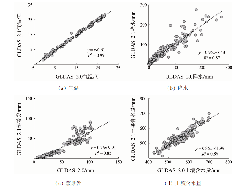
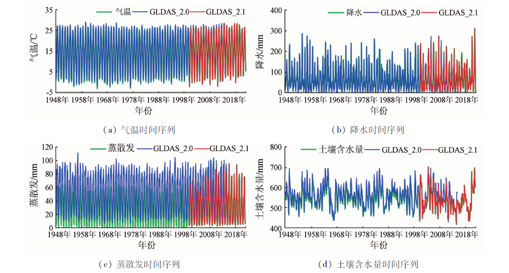
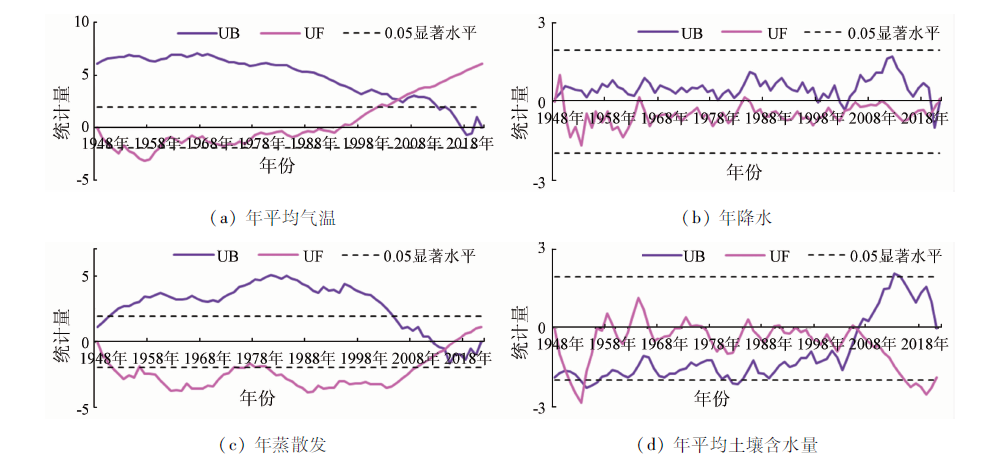
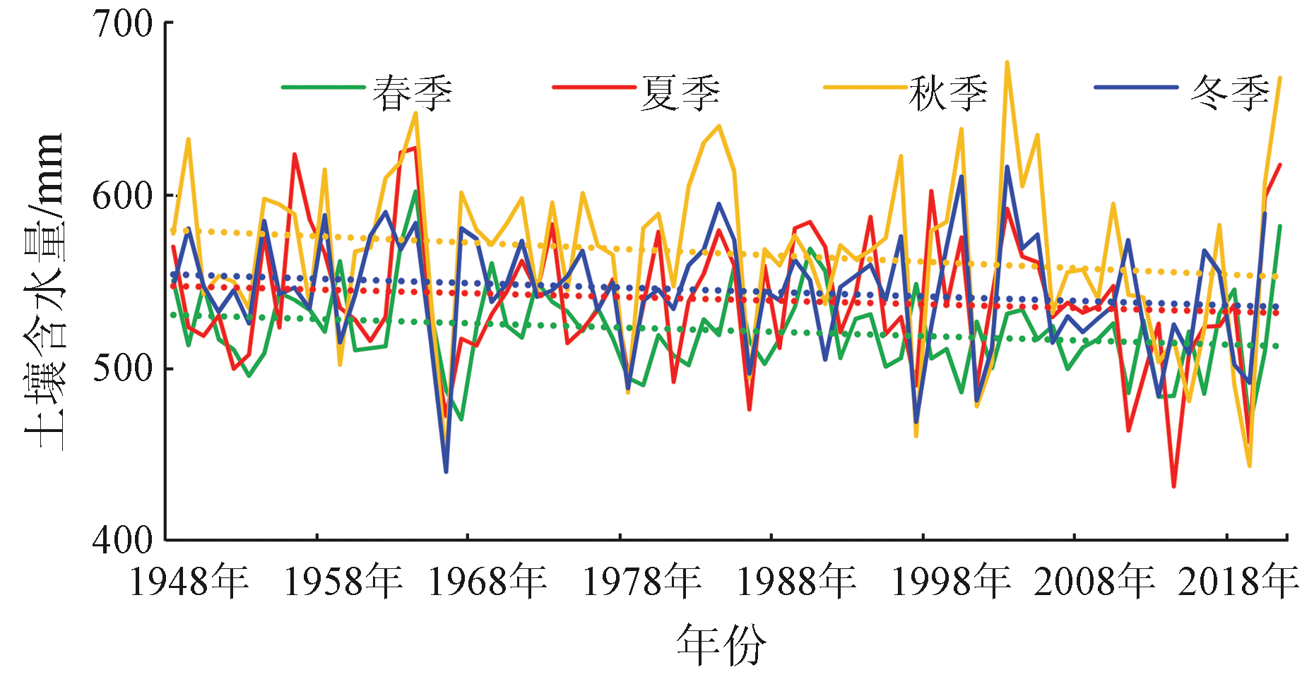
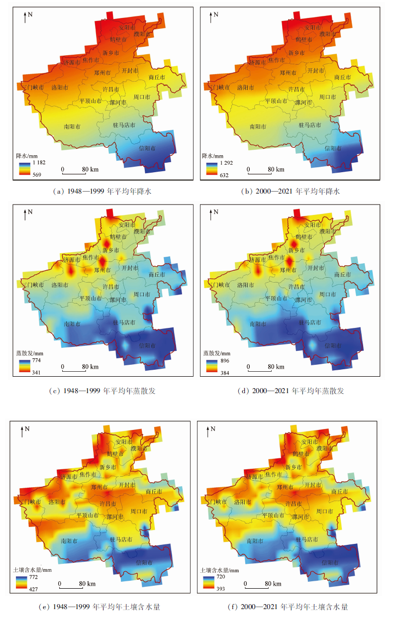
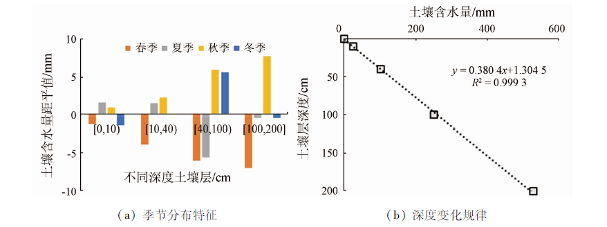
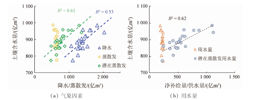
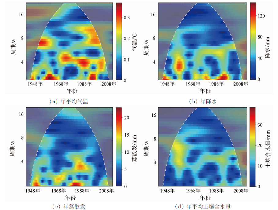
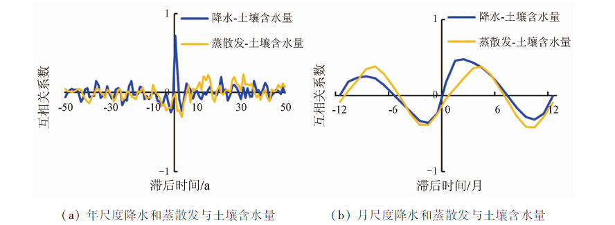
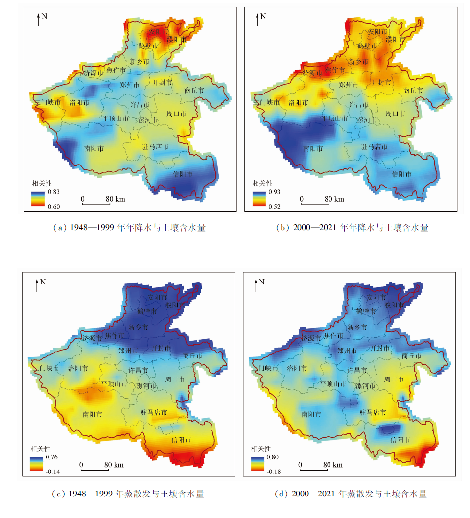
This study constructed a monthly soil moisture content dataset of Henan Province during 1948—2021 by combining 1948—2014 GLDAS_2.0 data and 2000—2021 GLDAS_2.1 data. Through the Mann-Kendall (M-K) trend analysis, mutation test, wavelet analysis, and cross-correlation analysis, this study revealed the spatio-temporal distribution and critical influencing factors of soil moisture content in Henan Province. The results show that compared with the monthly soil moisture content data provided by GLDAS_2.1, the reconstructed monthly soil moisture content data during 2000—2014 showed an average deviation, average absolute error, and root mean square error of 2.09 mm, 13.01 mm, and 18.26 mm, respectively, indicating reliable data. According to the constructed soil moisture content data, the soil moisture content decreased at a rate of 0.301 0 mm/a during 1948—2021, with change rates of -0.236 8 mm/a in spring, -0.085 5 mm/a in summer, -0.380 5 mm/a in autumn, and -0.240 3 mm/a in winter in Henan Province. Spatially, the soil moisture content decreased from south to north, highly consistent with precipitation and evapotranspiration. The soil moisture content was 2.63 mm/cm in the vertical direction. The wavelet and cross-correlation analyses show that precipitation is a critical factor influencing soil moisture content. This study revealed the long-time-series spatio-temporal distribution of soil moisture content in Henan Province, providing a basis for the scientific management of surface water resources in Henan Province.
郭艺, 甘甫平, 闫柏琨, 白娟, 邢乃琛, 刘琪. 1948—2021年河南省土壤含水量时空分布特征及其影响因素研究[J]. 自然资源遥感, 2023, 35(3): 241-252.
GUO Yi, GAN Fuping, YAN Bokun, BAI Juan, XING Naichen, LIU Qi. Spatio-temporal distribution and influencing factors of soil moisture content in Henan Province during 1948—2021. Remote Sensing for Natural Resources, 2023, 35(3): 241-252.
Lei Z P, Hu H P, Yang S X. A review of soil water research[J]. Advances in Water Science, 1999, 10(3):311-318.
[2]
Seneviratne S I, Corti T, Davin E L, et al. Investigating soil moisture-climate interactions in a changing climate:A review[J]. Earth-Science Reviews, 2010, 99(3-4):125-161.
doi: 10.1016/j.earscirev.2010.02.004
Xie W Y, Fan G S. Influence of moisture content on infiltration characteristics in field soils[J]. Journal of Taiyuan University of Technology, 2004, 35(3):272-275.
Zhu G F, Pu T, He Y Q, et al. Spatial and temporal variation of soil relative moisture in Hengduan mountainous region,China[J]. Scientia Geographica Sinica, 2012, 32(7):872-877.
Zhao L J. Study on remote sensing information model of soil water content in Beijing based on MODIS data[D]. Beijing: China Agricultural University, 2014.
[7]
Sonia I S, Thierry C, Edouard L, et al. Investigating soil moisture-climate interactions in a changing climate:A review[J]. Earth-Science Reviews, 2010, 99(3-4):121-161.
[8]
Nazmus S, Iliana M, John B. Leveraging Google Earth Engine for drought assessment using global soil moisture data[J]. Remoting Sensing, 2018, 10(8):1265.
[9]
Jostein B, Paul D H, Philipp S, et al. Monitoring soil moisture drought over northern high latitudes from space[J]. Remote Sensing, 2019, 11(10):1200.
doi: 10.3390/rs11101200
[10]
Rodell M, Houser P R, Jambor U, et al. The global land data assimilation system[J]. Bulletin of the American Meteorological Society, 2004, 85(3):381-394.
doi: 10.1175/BAMS-85-3-381
Liu R L, She D X, Li M, et al. Using satellite observations to assess applicability of GLDAS and WGHM hydrological model[J]. Geomatics and Information Science of Wuhan Unibersity, 2019, 44(11):1596-1604.
Qian A, Yi S, Sun G T, et al. GLDAS_NOAH_M.2.1 hydrological model and its application analysis in Qinghai-Tibet Plateau[J]. Journal of Geodesy and Geoodynamics, 2018, 38(3):254-259.
Wang W, Cui W, Wang P. Comparison of GLDAS NOAH model hydrological outputs with ground observations and satellite observations in China[J]. Water Resources and Power, 2017, 35(5):1-6.
Wang C Y, Ma Y X. Ecological and physiological effects on root systems of wheat under different soil water conditions[J]. Acta Agcultureal Boreali-Sinica, 1992, 7(4):1-8.
Wang J, Bian Y H, Chen Y D, et al. Estimation of soil moisture changes based on GRACE terrestrial water storage:Taking the monsoon region in eastern China as an example[J]. South to North Water Transfers and Water Science and Technology, 2021, 19(3):459-468.
Xu S F, Wang L S, Chen C, et al. Using GRACE and in-situ measurements to assess the applicability of GLDAS hydrological model in Tibet Plateau[J]. Journal of Geodesy and Geodynamics, 2018, 38(1):8-13.
Cheng S J, Guan X D, Huang J P, et al. Analysis of response of soil moisture to climate change in semi-arid Loess Plateau in China based on GLDAS data[J] Journal of Arid Meteorology, 2013, 31(4):641-649.
Shen R P, Zhang Y, Shi C X, et al. Inter-comparison of various long-time soil moisture datasets in China[J]. Meteorological Science and Technology, 2016, 44(6):867-874.
Zhang S W, Liu Y, Cao B J, et al. Soil moisture-precipitation coupling and trends in China,based on GLDAS and CMIP5 products[J] Climatic and Environmental Research, 2016, 21(2):188-196.
Wu P, Feng Y Q, Liang S H, et al. Soil moisture-precipitation coupling and trends in China based on GLDAS and CMIP5 products[J]. Journal of Beijing Normal University (Natural Science), 2016, 52(3):265-270.
Liu P P, Song H Q, Bao W W, et al. Applicability evaluation of CLDAS and GLDAS soil temperature data in Shaanxi Province[J]. Meteorological Science and Technology, 2021, 49(4):604-611.
Ai N, Qiang D H, Liu C H, et al. Dynamics of spring soil moisture in jujube forest in the semi-arid hilly area of Loess Plateau[J]. Research of Agricultural Modernization, 2019, 40(2):342-348.
He Q H, He Y H, Bao W K. Research on dynamics of soil moisture in arid and semiarid mountainous areas[J]. Journal of Mountain Science, 2003, 21(2):149-156.
Mihrigul A, Hamid Y, Mamattursum E, et al. Water level variations of Issyk-kul Lake based on wavelet analysis[J]. Research of Soil and Water Conservation, 2014, 21(1):168-172.
Qi X F, Yang L Z, Ye H, et al. Cross wavelet analysis of groundwater level regimes and precipitation-groundwater level regime in Ji’nan Spring Region[J]. Advances in Earth Science, 2012, 27(9):969-978.
Shao X M, Xu Y Q, Yan C R. Wavelet analysis of rainfall variation in the Yellow River basin[J]. Journal of Peking University (Natural Science), 2006, 42(4):503-509.
Zhang J Y, Zhang S L, Wang J X, et al. Study on runoff trends of the six larger basins in China over the past 50 years[J]. Advances in Water Science, 2007, 18(2):230-234.
[30]
Guo Y, Wang F, Qin D J, et al. Hydrodynamic characteristics of a typical Karst spring system based on time series analysis in northern China[J]. China Geology, 2021, 4(3):434-448.
doi: 10.31035/cg2021049
[31]
Bouchaoua L, Manginb A, Chauve P. Turbidity mechanism of water from a karstic spring example of the Ain Asserdoune spring (Beni Mellal Atlas,Morocco)[J]. Journal of Hydrology, 2002, 265(1):34-42.
doi: 10.1016/S0022-1694(02)00098-7
[32]
Fiorillo F, Doglioni A. The relation between Karst spring discharge and rainfall by cross-correlation analysis (Campania,southern Italy)[J]. Hydrogeology Journal, 2010, 18(8):1881-1895.
doi: 10.1007/s10040-010-0666-1
 2023, Vol. 35
  ), 甘甫平, 闫柏琨, 白娟, 邢乃琛, 刘琪