Comparing the applicability of five typical spatio-temporal information fusion algorithms based on remote sensing data in vegetation index reconstruction of wetland areas
LUO Jiahuan1(), YAN Yi1(), XIAO Fei2, LIU Huan1, HU Zhengzheng2,3, WANG Zhou2,3
1. Key Laboratory of Resources Conversion and Pollution Control of the State Ethnic Affairs Commission, College of Resources and Environment, South-Central Minzu University, Wuhan 430074, China 2. Innovation Academy for Precision Measurement Science and Technology, Chinese Academy of Sciences, Wuhan 430071, China 3. University of Chinese Academy of Sciences, Beijing 100049, China
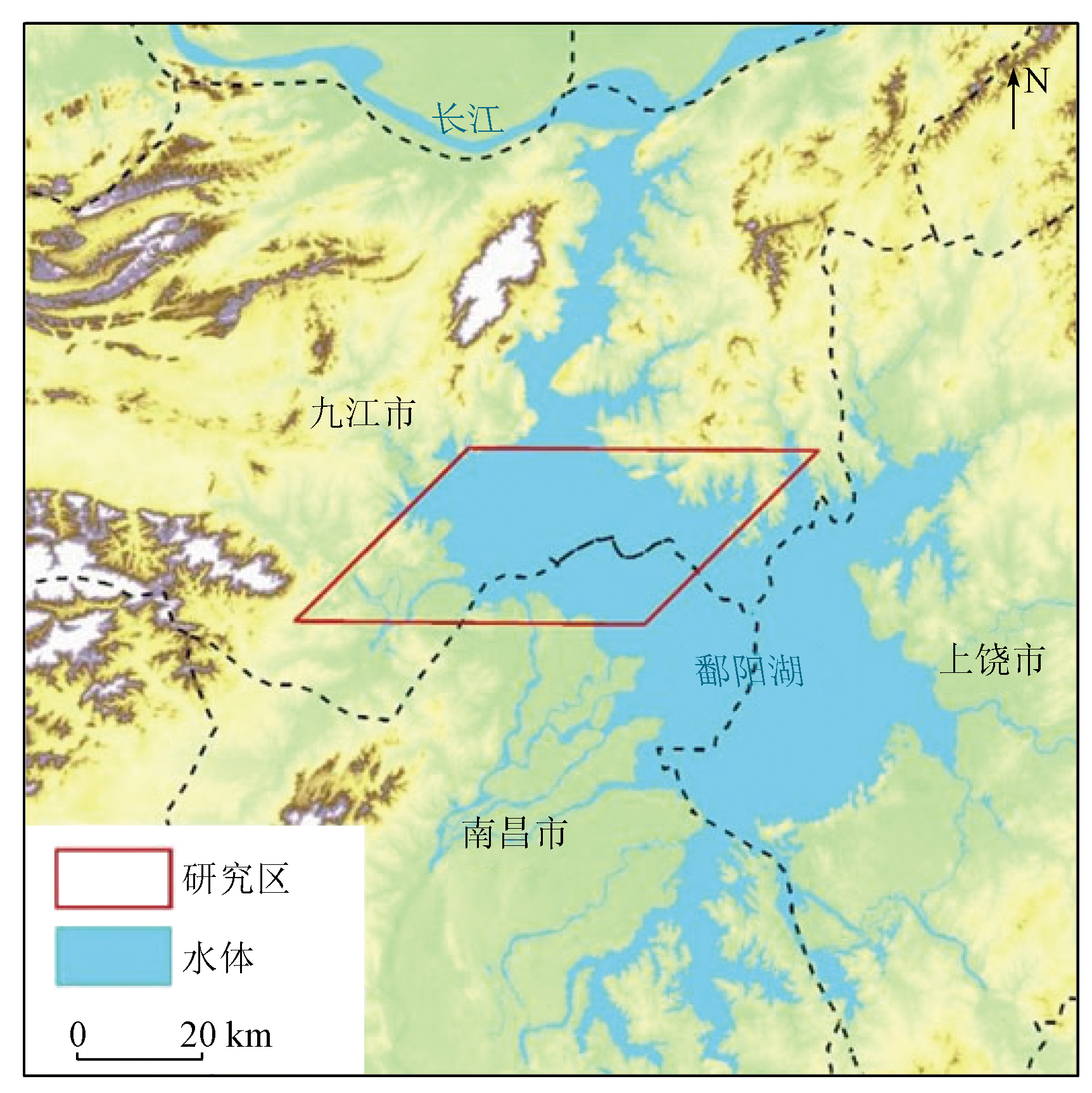
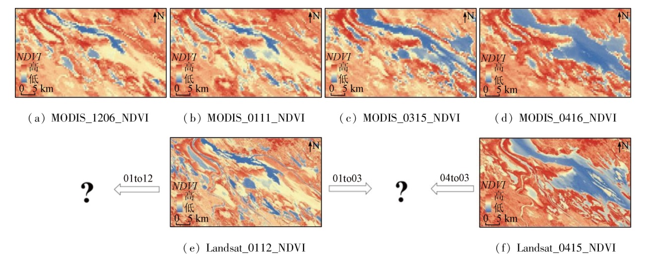
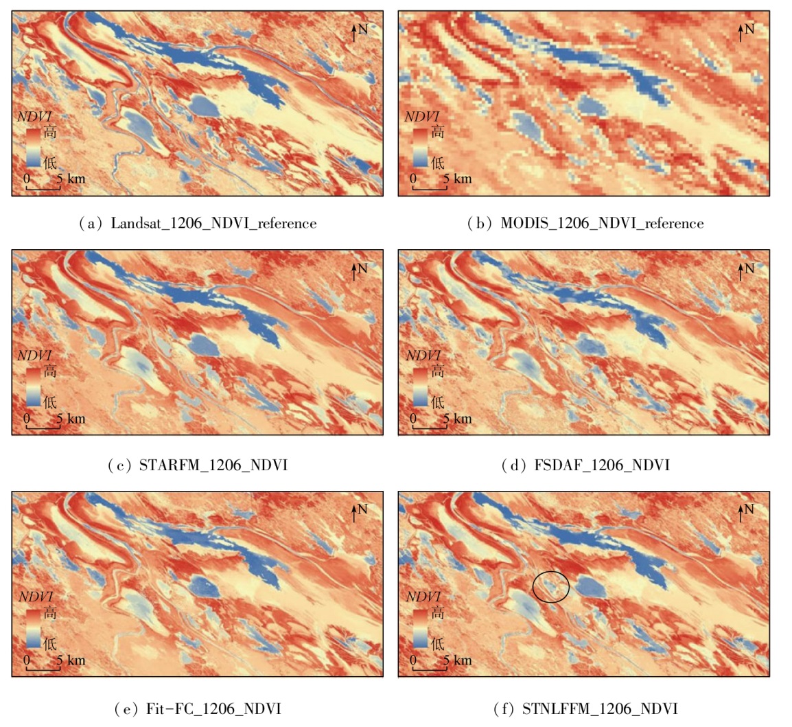
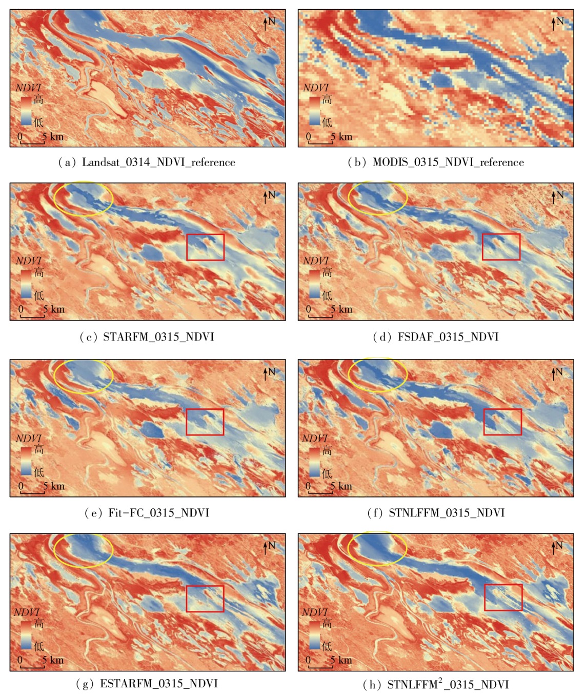
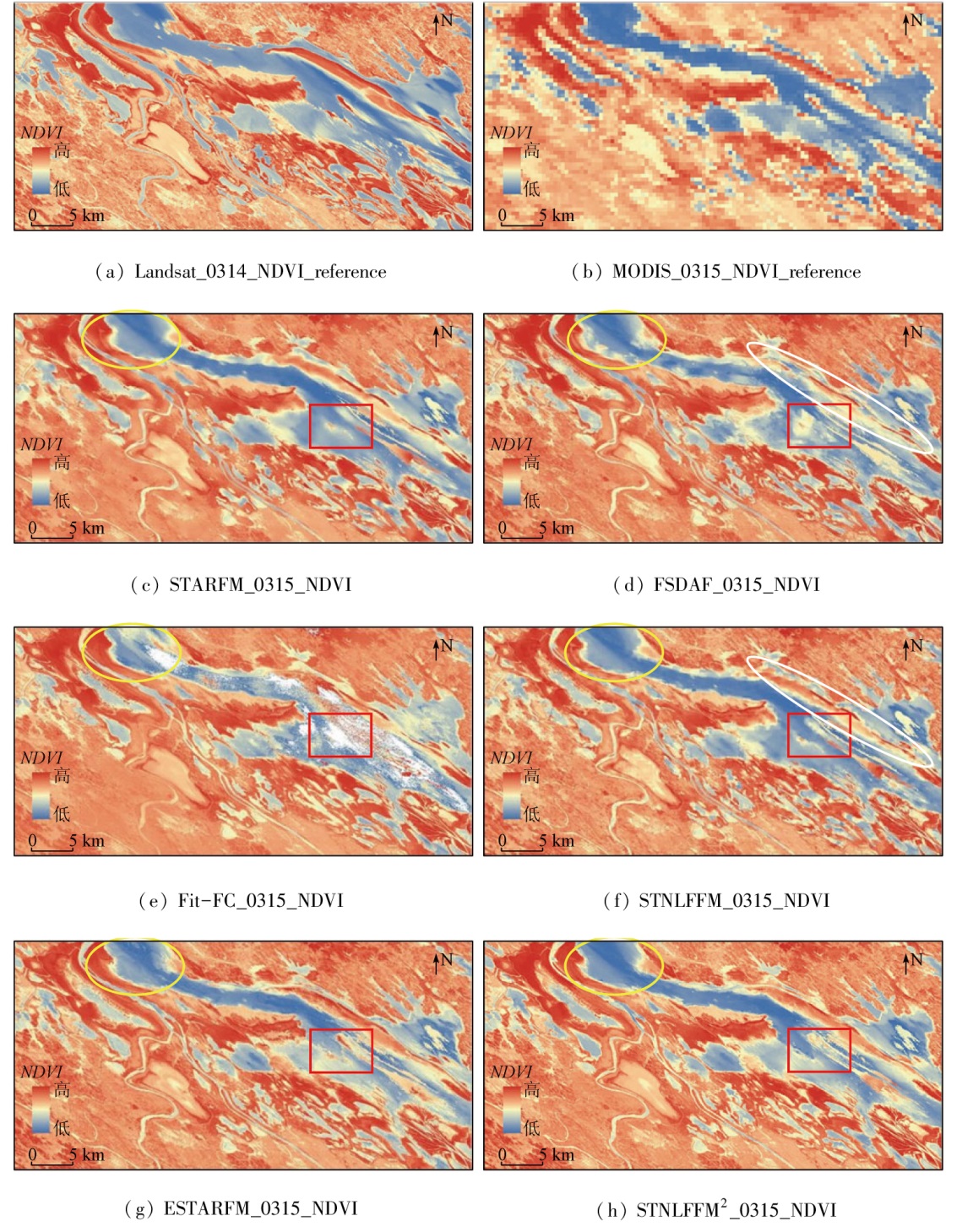
This study aims to explore the applicability of various spatio-temporal information fusion algorithms based on remote sensing data to wetland areas characterized by frequent land-water conversion and diverse surface features. With the Poyang Lake sample area as the study area, this study examined five typical spatio-temporal information fusion algorithms (STARFM, ESTARFM, FSDAF, Fit-FC, and STNLFFM). Considering the differences in surface features among different periods, Landsat and MODIS remote sensing data were selected to conduct image fusion experiments for normalized difference vegetation indices (NDVIs) during low- and normal-water periods. Moreover, the accuracy of these algorithms was evaluated in spatial and spectral dimensions. The results of this study are as follows: ① In the case of only one pair of coarse- and fine-resolution images as input, the FSDAF exhibited the optimal fusion prediction effect for the low-water period, with an overall error of 0.433 5, whereas the STNLFFM manifested the optimal fusion prediction effect for the normal-water period, with an overall error of 0.514 7; ② In the case of two pairs of coarse- and fine-resolution images of low- and normal-water periods as input, the ESTARFM demonstrated the optimal fusion prediction effect, with an overall error of 0.467 0; ③ The applicability of different algorithms to a wetland area is associated with the proportion of water bodies in the study area. The STNLFFM displayed the optimal fusion prediction effect for water bodies.
罗佳欢, 严翼, 肖飞, 刘欢, 胡铮铮, 王宙. 五种典型遥感时空信息融合算法在湿地区域植被指数重建中的适用性比较[J]. 自然资源遥感, 2024, 36(2): 60-69.
LUO Jiahuan, YAN Yi, XIAO Fei, LIU Huan, HU Zhengzheng, WANG Zhou. Comparing the applicability of five typical spatio-temporal information fusion algorithms based on remote sensing data in vegetation index reconstruction of wetland areas. Remote Sensing for Natural Resources, 2024, 36(2): 60-69.
Zhang L F, Peng M Y, Sun X J, et al. Progress and bibliometric analysis of remote sensing data fusion method(1992—2018)[J]. Journal of Remote Sensing, 2019, 23(4):603-619.
[2]
Nunez J, Otazu X, Fors O, et al. Multiresolution-based image fusion with additive wavelet decomposition[J]. IEEE Transactions on Geoscience and Remote Sensing, 1999, 37(3):1204-1211.
[3]
Acerbi-Junior F W, Clevers J G P W, Schaepman M E. The assessment of multi-sensor image fusion using wavelet transforms for mapping the Brazilian Savanna[J]. International Journal of Applied Earth Observation and Geoinformation, 2006, 8(4):278-288.
[4]
Gao F, Masek J, Schwaller M, et al. On the blending of the Landsat and MODIS surface reflectance:Predicting daily Landsat surface reflectance[J]. IEEE Transactions on Geoscience and Remote Sensing, 2006, 44(8):2207-2218.
[5]
Zhu X L, Chen J, Gao F, et al. An enhanced spatial and temporal adaptive reflectance fusion model for complex heterogeneous regions[J]. Remote Sensing of Environment, 2010, 114(11):2610-2623.
[6]
Zhu X, Helmer E H, Gao F, et al. A flexible spatiotemporal method for fusing satellite images with different resolutions[J]. Remote Sensing of Environment, 2016, 172:165-177.
[7]
Wang Q M, Atkinson P M. Spatio-temporal fusion for daily Sentinel-2 images[J]. Remote Sensing of Environment, 2018, 204:31-42.
[8]
Cheng Q, Liu H, Shen H, et al. A spatial and temporal nonlocal filter-based data fusion method[J]. IEEE Transactions on Geoscience and Remote Sensing, 2017, 55(8):4476-4488.
[9]
Walker J J, de Beurs K M, Wynne R H, et al. Evaluation of Landsat and MODIS data fusion products for analysis of dryland forest phenology[J]. Remote Sensing of Environment, 2012, 117:381-393.
Zhao Y L. Reconstruction of NDVI data with high-spatial and cemporal Vesolution using spatio-temporal fusion technique[D]. Taiyuan: Taiyuan University of Technology, 2015.
Zhang W, Li W, Tao G H, et al. Improvement of extraction accuracy for cropping intensity in complex surface regions using STARFM[J]. Journal of Agricultural Engineering, 2020, 36(21):175-185.
Guan Q H, Ding M J, Zhang H, et al. Analysis of applicability about ESTARFM in the middle-lower Yangtze Plain[J]. Journal of Geo-Information Science, 2021, 23(6):1118-1130.
Hao G B, Wu B, Zhang L F, et al. Temporal and spatial variation analysis of the area of Siling Co Lake in Tibet based on ESTARFM(1976-2014)[J]. Journal of Geo-Information Science, 2016, 18(6):833-846.
Cheng X Q, Hong Y T, Chen J S, et al. A study of the long-term remote sensing dynamic monitoring of inland based on ESTARFM[J]. Remote Sensing for Land and Resources, 2020, 32(3):183-190.doi:10.6046/gtzyyg.2020.03.24.
[15]
Zhai H, Huang F, Qi H. Generating high resolution LAI based on a modified FSDAF model[J]. Remote Sensing, 2020, 12(1):150.
[16]
Guo D Z, Shi W Z, Hao M, et al. FSDAF 2.0:Improving the performance of retrieving land cover changes and preserving spatial details[J]. Remote Sensing of Environment, 2020, 248:111973.
[17]
Li X D, Foody G M, Boyd D S, et al. SFSDAF:An enhanced FSDAF that incorporates sub-pixel class fraction change information for spatio-temporal image fusion[J]. Remote Sensing of Environment, 2020, 237:111537.
[18]
Chen B, Huang B, Xu B. Comparison of spatiotemporal fusion models:A review[J]. Remote Sensing, 2015, 7(2):1798-1835.
Xie S Y, Kuang R Y, Song Z H. Variation characteristics of water area Poyang Lake and its response to meteorological factors[J]. China Rural Water and Hydropower, 2022(7):103-109.
Yao J P, Yang L K, Chen T, et al. Consecutive monitoring of the Poyang Lake wetland by integrating Sentinel-2 with sentinel-1 and Landsat8 data[J]. Remote Sensing Technology and Application, 2021, 36(4):760-776.
Xu J, Wang Z Y, Tang S, et al. Investigation and analysis of the resources of wetland plant diversity in Poyang lake[J]. Journal of Northwest Forestry University, 2013, 28(3):93-97.
Shen L P, Fang C Y, Xiao X, et al. A dataset of fixed-point observations of 10 rare migratory birds in Poyang Lake from 2021 to 2022[J]. China Scientific Data Chinese and English online version), 2022, 7(3):324-333.
[23]
Zhu X L, Zhan W F, Zhou J X, et al. A novel framework to assess all-round performances of spatiotemporal fusion models[J]. Remote Sensing of Environment, 2022, 274:113002.
[24]
Hu Y, Wang H, Niu X, et al. Comparative analysis and comprehensive trade-off of four spatiotemporal fusion models for NDVI generation[J]. Remote Sensing, 2022, 14(23):5996.
[25]
Emelyanova I V, McVicar T R, Van Niel T G, et al. Assessing the accuracy of blending Landsat-MODIS surface reflectances in two landscapes with contrasting spatial and temporal dynamics:A framework for algorithm selection[J]. Remote Sensing of Environment, 2013, 133:193-209.
[26]
Zhou J X, Chen J, Chen X H, et al. Sensitivity of six typical spatiotemporal fusion methods to different influential factors:A comparative study for a normalized difference vegetation index time series reconstruction[J]. Remote Sensing of Environment, 2021, 252:112130.
Shi C L, Wang X H, Zhang M, et al. Analysis of the applicability of three remote sensing spatiotemporal fusion algorithms in flood monitoring[J]. Remote Sensing for Land and Resources, 2020, 32(2):111-119.doi:10.6046/gtzyyg.2020.02.15.
Lei C Y, Meng X C, Shao F. Spatio-temporal fusion quality evaluation based on “Point”-“Line”-“Plane” aspects[J]. National Remote Sensing Bulletin, 2021, 25(3):791-802.
 2024, Vol. 36
  ), 严翼1(